Climate Change Adaptation Series: Document 3
VILLAGE VULNERABILITY ASSESSMENT AND CLIMATE
CHANGE ADAPTATION PLANNING (V&A): KITONGA
VILLAGE, BAGAMOYO DISTRICT, TANZANIA
February, 2012
Prepared by the Pwani Project
This report is part of the Pwani Project’s Coastal Community Adaptation Series, which includes the following documents:
1. Coastal and Marine Ecosystems in a Changing Climate: the Case of Tanzania. 2. Workshop Proceedings: Tanzania Coastal Climate Change National Adaptation
Planning Workshop
3. Village Vulnerability Assessments and Climate Change Adaptation Planning (V & A): Kitonga, Bagamoyo District
4. Village Vulnerability Assessments and Climate Change Adaptation Planning (V & A): Mlingotini, Bagamoyo District
5. Rapid Assessment of Shoreline Characteristics and Dynamics of the Lazy Lagoon at Mlingotini Village, Bagamoyo
6. Livelihoods, Climate and Non-Climate Threats and Adaptation: Pangani District Coastal Villages
7. Livelihoods, Climate and Non-Climate Threats and Adaptation: Bagamoyo District Coastal Villages
8. Village Vulnerability Assessments and Climate Change Adaptation Planning (V & A): Jambiani and Paje, Zanzibar
9. Village Vulnerability Assessments and Climate Change Adaptation Planning (V & A): Kitonga and Mlingotini Villages, Bagamoyo District (Summary Report) 10.Village Vulnerability Assessments and Climate Change Adaptation Planning (V
& A): Mwembeni, Pangani District
11.Village Vulnerability Assessments and Climate Change Adaptation Planning (V & A): Sange, Pangani District
This publication is available electronically on the Coastal Resources Center’s website at http://www.crc.uri.edu. For more information contact: Coastal Resources Center, University of Rhode Island, Narragansett Bay Campus, South Ferry Road,
Narragansett, Rhode Island 02882, USA. Tel: (401) 874-6224; Fax: (401) 874-6920. Citation: Mahenge, J., Mkama, W., Robadue, D., Tobey, J. (2012). Village-Level Vulnerability Assessment and Climate Change Adaptation Planning (V&A) for Kitonga Village, Bagamoyo District, Tanzania. Coastal Resources Center, University of Rhode Island, Narragansett, RI, 18 pp.
Disclaimer: This report is made possible by the generous support of the American people through the United States Agency for International Development (USAID). The contents are the responsibility of the Coastal Resources Center at the University of Rhode Island as part of the Tanzania Coastal Management Partnership/Pwani Project, Cooperative Agreement No. 621-A-00-10-00012-00.
Contents
1. INTRODUCTION 1
2. METHODOLOGY 3
3. CLIMATE CHANGE PROJECTIONS AND TRENDS 5
4. LOCAL KNOWLEDGE ON CLIMATE CHANGE TRENDS AND IMPACTS 6
5. VULNERABILITY ASSESSMENT 9
6. ADAPTATION OPTIONS 12
7. STUDY TOUR EXCHANGE 13
8. CONCLUSIONS AND RECOMMENDATIONS 14
REFERENCES 15
List of Figures
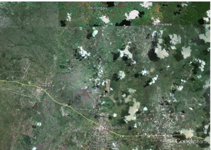
Figure 1 Aerial View of the Ruvu River Flood Plain along with position of Kitonga
Village ... 2
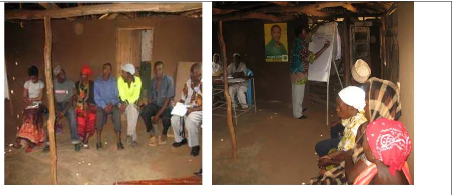
Figure 2 Focus Group discussions at Kitonga Village ... 4
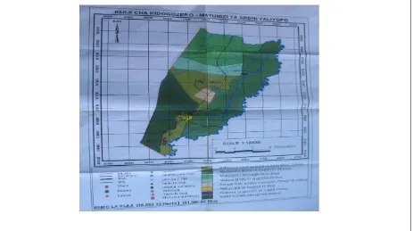
Figure 3 Kidogozero Village Land Use Plan including Kitonga ... 6
Figure 4 Monthly mean flow of the Ruvu River near Kitonga Village ... 7
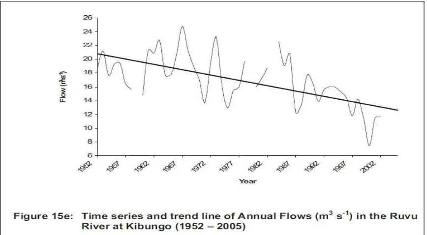
Figure 5 Annual flow trends of the Ruvu River ... 7
Figure 6 Establishing a mango fruit tree planting orchard – one of the recommendations from the V&A assessment ... 12
Figure 7 Exchange between Kitonga and Mlingtotini ... 13
List of Tables Table 1 Summary of agricultural activities carried out in Kitonga Village ... 8
Table 2 Concerns and Opportunities for Kitonga Village ... 9
1. INTRODUCTION
There is now wide agreement by most scientists and climate change professionals that climate change and increased climate variability are already occurring and having serious consequences for many African countries, including Tanzania. The predictions from the experts on climate change are that the problems caused by climate changes will increase and make management of coastal ecosystems and improvements to community resilience even more difficult. The following threats are predicted to cause major problems for coastal resources and the well-being, safety, and food security of coastal communities:
1. More unpredictable precipitation (seasonality and intensity) 2. Increases in strong storms
3. Sea level rise
4. Increased sea surface and ambient air temperatures 5. Increased ocean acidification
These climate and chemical threats and the problems they create are on top of and in addition to existing local stresses. In most of coastal Tanzania, these include deforestation, over fishing, deterioration in water supply and quality, and development pressures.
Beginning in 2010, the Pwani Project initiated an effort to help local leaders and government to assess climate change impacts and find ways to adapt to current and future climate change impacts in a strategic way using their own resources and knowledge. This is part of a larger coastal management effort in a partnership with the government of Tanzania and the United States Agency for International Development (USAID). This Project has a geographic focus on the island of Unguja in Zanzibar and the ecologically important northern coast of
mainland Tanzania – Bagamoyo and Pangani Districts. The overall goal is to help sustain the flow of environmental goods and services; revise the trend of environmental destruction of critical coastal habitats; and improve the wellbeing of coastal residents in the Bagamoyo-Pangani and Menai Bay Seascapes.
The initial work on climate change targeted two coastal, rural villages in Bagamoyo District – Mlingotini and Kitonga. Kitonga is not directly on the coast, but is in the flood plain of the Ruvu River (Figure 1). Here, people are also very dependent on the natural resource base for agriculture, especially rain fed rice farming, vegetables and fruits. In these rural villages people are close to the sea, the rise and ebb of the tide, and the seasonality of rain and prevailing winds. They are aware of climate change and climate variability and how it is impacting their lives.
The Pwani Project, in partnership with District government staff and CEEST, a local NGO began a process of meeting with and working with village leadership in the two locations to conduct village-level climate change vulnerability assessments and adaptation planning (V&A). In each village, a 12 person Community Climate Change Committee (4C), with an equal number of men and women was formed. This report documents the methods used and results of the V&A.
Specific objectives of village-level V&A include the following:
• Find local champions for climate change adaptation actions
• Demonstrate low cost, low technology methods for vulnerability assessment and adaptation planning
• Share experience and best practices across villages and with District government The overall goal is to maintain healthy coastal ecosystems and reduce the harmful effects of climate change impacts on coastal communities. The intention of the Pwani project is to transfer and build on the lessons learned from this experience in V&A to other coastal villages in the Pwani Project area.
2. METHODOLOGY
Vulnerability is defined as the degree to which a human or natural system is susceptible to,
or unable to cope with, adverse effects of climate change. Vulnerability is a function of the character, magnitude, and rate of climate variation to which a system is exposed, its
sensitivity, and its adaptive capacity.
Following the guidance of the USAID report “Adapting to Coastal Climate Change: A Guidebook for Development Planners” (available at http://www.crc.uri.edu/download/ CoastalAdaptationGuide.pdf), this V&A exercise sought to understand the potential impact of climate change and climate variability and develop an initial list of response options (planned adaptation measures). Planned adaptation is a process of deliberate decision making to take societal actions to reduce harm or exploit beneficial opportunities in response to actual or expected climatic changes or their impacts.
Potential impact is a function of both climate and non-climate stresses and vulnerability factors. Vulnerability factors are the types and amount of assets at risk (exposure), the degree to which those assets and people are impacted (sensitivity), and the ability to cope with actual or expected changes (adaptive capacity).
Kitonga was selected because of its vulnerability to climate change threats and locally expressed interest in assessing climate change and finding ways to limit harmful impacts. Kitonga village is located close to the Ruvu River and is influenced by river flooding events. Kitonga village was formally a sub village of Kidogozero village but now is a registered village with 5 sub villages (these are Mtambani, Shuleni, Msawanga, Mji Mpya and Kisiwani). Kitonga is relatively small in population size, in the order of 2,000 residents. Qualitative focus group meetings were used to gather information from villagers on vulnerability and adaptation options in August 2010. The focus group comprised of 12 individuals, with an equal number of men and women. Focus Group members were comprised of village leaders from the Village Council and other positions of leadership. When meeting the group, the objectives of the meeting and the meaning of climate change were explained. In Swahili, climate change can be translated as 'tabia nchi' = climate and badiliko = change'. Most of the participants were already aware of climate change and how menacing it can be though the main understanding focused on weather change.
During the discussion, a flip-chart was used to record information. This was done by one researcher and another acted as a facilitator of the session. The facilitator moderated the group process and also:
• Acted as a catalyst between the individuals of the group
• Integrated dominant and quiet people and made sure that all group members were able to express their opinions
• Made sure that the group kept to the topic while being flexible in handling additional important information
• Repeated in his own words what people said to confirm that there was a good understanding
Figure 2 Focus Group discussions at Kitonga Village
Participatory Rapid Appraisal (PRA) tools were applied with the village focus group. The tools that were used included the following:
1. Seasonal calendar. A seasonal calendar is a participatory tool to explore seasonal
changes (e.g. rainfall patterns, food availability, income, gender-specific workload, diseases, and expenditure) that affect vulnerability.
2. Community time line. The purpose of the time line is to help the community better
understand what historic natural and human events have influenced the lives of the communities. It facilitates discussion and examination of past trends and problems. It is useful in adaptation planning to think back on these past events and experiences and look at how they influence present attitudes and community responses. The events which are recorded on the time line may include movements of people, introduction of new technology, natural disasters, and development decisions. In developing a time line community members record back as many generations as they can.
3. Community animal and plant inventory. The purpose is to collect information on
local biodiversity. Communities often build an intimate knowledge of the plants and animals which share their land. The inventory provides for a quick method of obtaining what plant and animal types are known to be within a community's boundary.
4. Review of results and linking results from different tools to climate change. The
purpose is to identify climate change impacts with respect to the seasonal calendar, community time line and inventory of plants and animals. This can include changes in seasonality, changes in the intensity and frequency of storms and precipitation, and changes in abundance of plants and animals and their cause.
5. Identification of concerns and opportunities. The purpose is to help the focus
group to identify and prioritize specific community concerns and to look for possible ways to solve or address them.
6. Identification of community values. The purpose is to encourage discussion about
7. Priority community values. The purpose is to assist the focus group to determine
which objects, assets or cultural values are of greatest importance to the group as a whole.
8. Root cause analysis. The purpose is to determine whether climate change is a
contributing factor to identified community concerns. Root Cause Analysis is a useful tool that enables the focus group to identify the many parts of a problem, the dominant causes and the most effective areas for action.
9. Two way vision. The purpose is to determine how communities perceive climate
change will impact their lives and how they would like their future to be like instead. 10.Assessment of adaptation options. The purpose is to identify a range of actions that
could be undertaken to address issues relating to impacts of climate change or integrity enhancement objective (for example, maintain a certain reef area in good condition, or protect a certain forest area) while also meeting community development objectives. Systematically, the focus group assesses the appropriateness and prioritizes each of these possible actions for each climate change issue or objective.
11.Community action plan. With agreed to priority adaptation actions, the focus group
defines WHO will be responsible for it, WHAT resources will be needed and by WHEN it will hopefully be completed.
3. CLIMATE CHANGE PROJECTIONS AND TRENDS
Large scale climate change models and projections, such as those of the Intergovermental Panel on Climate Change (IPCC), as well as on-line regional mapping tools and downscaling models provide a starting point to understand large-scale climate change projections but lack the resolution and specificity needed to assess climate change at the scale of individual villages, or even Bagamoyo District.
The overall projection for Tanzania is that sea level will rise, surface water temperature and ambient air temperature will rise, the sea will become more acidic from carbon sequestered in the sea which then forms carbonic acid, and areas with bimodal rainfall patterns (as in Kitonga) will experience increased rainfall events, but also drought. These are the trends suggested by existing models and research.
More intense rainfall over the rainy season can cause flooding and loss of crops. Higher sea temperature can result in coral bleaching and mortality, increase incidence of disease in marine animals, and alter the seasonality of biological events and abundance and distribution of fish.
4. LOCAL KNOWLEDGE ON CLIMATE CHANGE TRENDS AND IMPACTS
The use of the Participatory Rapid Appraisal tools with the focus group in the village resulted in information on seasonal changes, historical trends, and changes in plant and animal biodiversity that could be partly caused by global climate change and climate
variability. Kitonga has been subject to a long history of environmental degradation and non-climate stressors making it difficult to associate many of the environmental and resource trends with global climate change.
Kidogozero village, about 70 km inland from Dar es Salaam, consists of a number of
discrete groups of homesteads, separated by seasonally-flooded land, extending more than 2 km along the west bank of the Ruvu River and set back about 0.5 km from it. Kitonga sub-village is a nuclear settlement, well away from the river and 2 km from Kidogozero.
The Ruvu River has permanent water, though seasonal levels vary by about 10 meters; at its lowest level, water in the main sandy riverbed may be less than 1m deep. It is at this season when crocodiles (which are protected under Convention on International Trade in
Endangered Species - CITES) present a maximum risk. Kitonga village has about 300 households. These households are involved in production of different vegetables. These perishables are taken to Dar es Salaam market every day. Some fishing (in river channels and lakes) is also carried out in lakes formed by the meandering of the Ruvu River.
Figure 3 Kidogozero Village Land Use Plan including Kitonga
increased significantly in the past 50 years while there is a declining trend in mean annual flow (Yanda, 2007).
The timing and intensity of the long and short rains are no longer reliable. In the past, rains early in the primary rainy season were heavy and these were followed later by small continuous rains which resulted in a good soaking of the soil. Presently rains early in the season are heavy and these are followed by dry conditions, which are not conducive to crop growth. For example, the drizzle that used to fall at the end of the rainy season has
disappeared. This drizzle helped cassava to grow well. Now, yield and quality of cassava has diminished. Rains in the smaller rainy season in October are now of short duration (barely
Figure 4 Monthly mean flow of the Ruvu River near Kitonga Village
more than two weeks) and they are usually of low intensity compared with the past. Without predictable primary rainy season precipitation and smaller rainy season, agricultural
planning under rain fed agriculture is difficult and food security is endangered.
In Kitonga, the primary impacts of concern, which the Focus Group believed are tied to anthropogenic causes of global climate change, are floods and drought. In 1996 and again in 2006, floods destroyed all food crops resulting in wide spread hunger in the village. Drought was experienced in 1997, 1998, 2000-2004, 2008 and 2009.
The seasonal calendar for Kitonga village falls within four periods, namely December to April, April to May, June to September and October to November respectively according to Table 1:
o October to February agricultural activities include land preparation and planting paddy. These activities are carried out by both men and women. In this period food is abundant in the village and is in the period of the end of the short rains and beginning of the long rains.
o March to May is the “Masika” (long rains) rainy period. The main activities are weeding paddy and scaring away birds. Food and income are very scarce at this time of the year.
o June to July some people would be tending crops (weeding and scaring away birds) while others would be harvesting paddy. The food situation is usually satisfactory at this time of the year.
o August to October is the beginning of the short rainy season. Agricultural activities include cultivation and harvesting of vegetables (pigeon peas, cowpeas, and maize). Food is usually abundant at this time of the year as every house hold will have harvested paddy.
Table 1 Summary of agricultural activities carried out in Kitonga Village
Month Activities Food Situation
October – February Land preparation for agriculture and planting
paddy Food is abundant
March- May Weeding paddy and scaring away birds Food scarcity and low income
June - August Weeding paddy and scaring away birds, paddy
harvesting, and cultivation of vegetables Food is abundant
September - October Harvesting vegetables, short rains crop production
5. VULNERABILITY ASSESSMENT
Participatory rural appraisal methods were used in the assessment process to capture issues that members of the community were concerned with:
1) Increased food insecurity due to drought, plant pests and diseases and floods
2) Inadequate water for domestic use due to the long distance to get water by foot, and the high cost of purchasing water from water vendors
3) Damage to homes due to frequent floods
4) Low income due to lack of employment and differentiated products
5) Animal diseases as a result of inadequate fodder and water in the dry season
The participants further analysed their concerns and identified potential opportunities for addressing them.
Table 2 Concerns and Opportunities for Kitonga Village
Concerns Opportunities
• Use of Ruvu River for irrigation Decrease in food security as the results of: • The use of dams for fish production
• Drought • More vegetable production for food
• Plant pests and diseases diversification
• Flooding of crops • Careful use of pesticides to prevent diseases
crop
Water problems for domestic uses: • Cost of water from vendors
• Long walk to fill water containers and carry back
• • •
Construction of dam or wells for storing water
Constructing tanks for storing water Development of a solar energy water supply system
• Destruction of homes from flooding • Construction of brick or cement houses with good foundations
• Loss of income
o No employment as the results of drought and floods
o No agricultural products to sell at the market
• • •
Irrigate using Ruvu River during drought Grow fish by creating dams
More household vegetable production
• Inadequate fodder and water supply livestock
for •
Construction of wells for water storage
• Plant diseases • Careful use of pesticides
As described earlier, vulnerability factors are the degree to which the particular area and people are impacted (sensitivity), the types and amount of assets at risk (exposure), and the ability to cope with actual or expected changes (adaptive capacity).
Table 3 Potential Impact of Climate Change –Kitonga
Asset at risk Degree of impact
Property and Infrastructure
Roads and property
Flooding erodes roads and damages homes, vegetation, and livestock along the main inundation and water flow routes
Ecological Assets
Agricultural land and crops
Changing precipitation patterns and both flood and drought events have a dramatic impact on crop
productivity and in some cases total loss of production
Landscapes and habitat Flooding of the Ruvu River has been responsible for the inundation of riparian habitat
Social Assets
Health and education
Flooding, drought, and changes in seasonality reduces agricultural productivity and the community’s
nutritional health. Reduced income affects families’ ability to financially support children in school and may lead to children being pulled out of school.
Adaptive capacity refers to the ability of society to change in a way that makes it better
equipped to manage its exposure and/or sensitivity to climate influences. A community with the capacities to adapt is likely to be more resilient or able to recover from stressful events and conditions.
A broad range of factors reflect adaptive capacity: • Political leadership and commitment • Systems of local government
• Resource availability (e.g., human, physical, technological, and financial) • Social capital
• Communication systems • Health of the environment
On a practical level, assessing adaptive capacity needs to answer questions such as:
Adaptive Capacity Questions
How well do community members work together on coastal development planning and coastal management, including coastal hazards?
What practices are currently employed to cope with natural hazards? Who is responsible for developing and implementing such measures? How effective are they?
Are decision-makers and the community in general informed and engaged?
Do most people rely on the same activity for their livelihoods? For example, does everyone rely on fishing or agriculture, such that a single event could leave everyone in the
In an emergency, are there multiple means of communicating or transporting people and supplies? Or will damage to a single road or bridge isolate the community?
How healthy are the ecosystems and how well are natural resources managed?
Assessing adaptive capacity of a place helps in understanding why vulnerability exists in the first place. To reduce vulnerability, stakeholders must understand its root causes. Root causes might include poverty, natural resource dependency and strong dependence on single livelihoods, weaknesses in local governance, degraded resources, and insecure or inequitably distributed property rights. Adaptive capacity can be strengthened through policies and actions that address the root causes.
On many levels, adaptive capacity in Kitonga is weak. Pervasive poverty and lack of rules
for effective water management were identified as root causes of vulnerability. Also, it is
the case that most people rely on the same activity for their livelihood (fishing, agriculture, or seaweed farming). In Kitonga, the health and resilience of the ecosystems has been compromised by deforestation for charcoal making. Finally, the community is dependent on a single road.
6. ADAPTATION OPTIONS
The vulnerability assessment identified numerous climate change risks and potential impacts. It showed some of the root causes for weak adaptive capacity. In both villages, there are more climate change risks than can be acted upon based on local funding availability, and institutional and technical capacity.
The villages and district government need to look for adaptation measures that are doable with concrete benefits, or actions that increase the adaptive capacity and reduce the sensitivity of assets to climate change. Given these criteria, the initial discussion and brainstorming of opportunities to adapt to climate change included the following:
• Form a Committee with District assistance and in cooperation with the Wami- Ruvu Water Basin Office to set rules for effective water management
• Plant fruit trees to generate an alternative source of income to reduce food insecurity
• Improve or introduce the use of efficient irrigated agriculture from the Ruvu River after seeking assistance and permits from the Wami-Ruvu Water Basin Office.
• Apply good practices in rice production to increase harvests and food security, and reduce climate change impacts. These include appropriate spacing and density of seeds, water retention techniques, and use of drought resistant seed. In addition, the village suggested better control of pests and diseases in crops and in livestock; storing fodder for dry season feeding; and, adapting better livestock feeding techniques.
• Develop a local education program to raise awareness on the importance of forest conservation
• Seek assistance on energy efficient technologies to reduce consumption of wood used for cooking
• Seek government or donor assistance to develop rainwater storage systems and adequate water tanks for water storage
Some of these opportunities can be done with existing local resources and skills, others require outside assistance and funding.
Other options were listed during brainstorming sessions on opportunities that are longer term and would require major outside investments (e.g. building or improving health or
educational facilities; improved home construction; road improvements; well construction; water delivery systems; irrigation systems; and, construction of dams for fish farming). A characteristic of the short-term responses listed above is that they are all “no-regrets.” This means that they yield benefits independent of climate change. These measures address current vulnerabilities and focus on increasing the ability of ecosystems and communities to cope with current environmental pressures and climate variability. They provide a benefit now, a benefit in the future, and potentially provide a benefit whether or not the projected climate changes become reality.
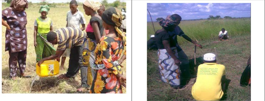
7. STUDY TOUR EXCHANGE
On two different days, the 12 Climate Change Focus Group members from Kitonga Village made a study tour to Mlingotini (another Bagamoyo District village that had also been part of a V&A process) and vice-versa. The aim was to increase each village’s awareness of climate change impacts, vulnerability, and adaptation options, and extract indigenous knowledge from the communities. In the climate change exchange visit between villages, Bagamoyo district staff also participated. The involvement was an opportunity for the district to understand in depth the climate change problems in the community with the hope that future district plans mainstream adaptation measures.
The study tour visits were also an opportunity for district extension staff to offer suggestions for change to reduce climate change vulnerability. For example, during the visit, Bagamoyo district staff provided technical assistance regarding good practices in rice production to increase harvests and food security, and reduce climate change impacts. These practices include water retention techniques, appropriate spacing of the plants, appropriate quantity of seeds per acre, and consideration of drought resistant seed.
Kitonga villagers showing Mlingotini study tour members the effect of climate change to rice production.
Mlingotini villagers showing Kitonga study tour members the area where there was “Poteza Forest” that in the past was dense with wild animals.
8. CONCLUSIONS AND RECOMMENDATIONS
The V&A exercise demonstrated that with appropriate PRA exercises and local knowledge, it is possible to conduct a vulnerability assessment and identify response options. Once strategically selected adaptation measures are implemented, their effectiveness and impact needs to be tracked, and improved approaches or new responses selected based on changing circumstances and new information.
Having completed this exercise with the villages, it raises some questions and information gaps. These questions and gaps can help focus the District, donors, and researchers on work in the future. For example, basic scientific information is needed on the inherent dynamics of the natural environment (e.g. coastal processes of sand movement, erosion, and accretion), sea level monitoring, and time series data on rainfall to better evaluate trends in high precipitation/flooding events, drought, and seasonality. Without such information, it is difficult to determine whether the observed climate changes are evidence of global climate change or not.
Also, to aid in assessing vulnerability and adaptation planning, it would be helpful to have remotely sensed land use/land cover maps to visualize climate change scenarios and biophysical impacts (e.g. maps of the shoreline to visualize erosion and maps of potential flooding or inundation from sea level rise and storm surge).
REFERENCES
This report is an updated and expanded edition of material originally presented in the following documents:
Mahongo, S.B. (2009). The Changing Global Climate and its Implication on Sea Level Trends in Tanzania and the Western Indian Ocean Region. Tanzania Fisheries Research Institute (TAFIRI) Western Indian Ocean J. Mar. Sci. Vol. 8, No. 2, pp. 147 - 159, 2009
Meena, Hubert and Maynard Lugenja, (2011), Climate Change Vulnerability Assessments For Mlingotini And Kitonga Villages, Bagamoyo District, Tanzania,. Final Draft Report. Center for Coastal Resources Center, University of Rhode Island,
Narragansett, RI, 57 pp.
Tobey, Jim , Hubert Meena, Maynard Lugenja, Jairos Mahenge, Wilbard Mkama, Donald Robadue (2011), Village Vulnerability Assessment and Adaptation Planning: Mlingotini and Kitonga, Bagamoyo District, Tanzania, Coastal Resources Center, University of Rhode Island, Narragansett, RI, 20 pp.
Yanda, P. Z., Munishi, P. K. T. (2007) “Hydrologic and Land Use/Cover Change Analysis for the Ruvu River Watershed,” Institute of Resource Assessment, University of Dar es Salaam, and Faculty of Forestry & Nature Conservation, Sokoine University of Agriculture Morogoro, prepared for WWF/CARE Dar es Salaam, Tanzania, March, 2007.
Notes:
The PRA tools are described in length in the document “Climate Change Vulnerability and Adaptation Planning Template,” manuscript, September 2010, available on request from James Tobey ([email protected]).