IJERD : Indexing
IJERD is now being indexed with Index
Copernicus
Google Scholar
Informatics
ProQuest
Research Gate
Docstoc
Scribd
UlrichWeb
Internet Archive
Academia.edu
Computer Science Directory
Wepapers
Geond
Auburn University
Aalborg University
Queen’s University
Goethe University
ISSN(Online) : 2278-067X
ISSN(Print) : 2278-800X
ISO Certified
International Journal of Engineering Research and Development(IJERD)
E-mail: [email protected]
International Journal of Engineering Research and Development
e-ISSN: 2278-067X, p-ISSN: 2278-800X, www.ijerd.com Volume 11, Issue 02 (February 2015), PP.01-09
1
Geographic Information System o
f Indonesia’s
Wifi Based on
Android Platform
Made Sudarma
1, Made Sukarsa
2,Karmila Devi
31,3
Department of Electrical and Computer System Engineering, Udayana University, Bali, Indonesia
2
Department of Information Technology, Udayana University, Bali, Indonesia
Abstract:- Indonesia’s Wifi currently is widely used for internet access, so that it is carried out the installations
on several areas of Bali. Its installations are carried out on public areas, in order to be easy to access by the customers, so it is important to find out the location which it has been installed. Given that a lot of users wish to have fast, cheap and flexible access. However so far there are several employees and customers complain the location of Indonesia’ Wifi which is very difficult to find so that there is an inconvenience from the side of customer and the difficulty to perform the correction when there is a failure from the side of employee. After observation has been conducted, the cause of the difficulty to find the position of Indonesia’ Wifi is because of
poorly organized data of the position of Wifi’s installation.
On the research being conducted it will be used a method to accomplish it that is by using LBS (Location of Based Service) method. The method will simplify in conducting the design toward the path map based on latitude and longitude coordinate. The system development has its function to retrieve the mapping of
Indonesia’s Wifi in one region. The development mentioned is by creating interactive mobile application namely Geographic Information System based on Android. Map viewing will classify the region which has been
installed of Indonesia’s Wifi and can provide information of the path to be taken. It is expected from this
research it may be able to help the public to find the location of Indonesia’s Wifi and it is useful for the
employee in conducting the repair of Indonesia’s Wifi network.
Keywords:- Geographic Information System, Indonesia’s Wifi, Android, Location Based Service
I.
INTRODUCTION
1.1. Background
The product of Indonesia’s Wifi is one of products which can provide the best service for its users. By
the increase of the customers then the problems being faced will be increased too. Most of internet users who are using the product of Indonesia’s Wifi as the support for office activities, study and teaching so that it can be a reason why it is necessary for Wifi to be installed evenly.
By the increasing of internet users who are using the product of Indonesia’s Wifi making the users wish
to find out the location of available Indonesia’s Wifi, but they also experiencing the lack of information regarding the location of Indonesia’s Wifi so that they often find difficulties in finding hotspot location of Indonesia’ Wifi. Other obstacles arise is from the aspect of difficulty in repair when there is a faulty, a lack of
efficiency of cable usage which causing the swelling of budget in installation of Indonesia’s Wifi.
One of solution in this problem is by creating the mobile interactive application of Geographic Information System (SIG) based on Android. This SIG Android is the set of organized computer hardware, software, geographic data and personnel which are designed efficiently to obtain, store, update, manipulate, analyze, and display all the form of information which has geography reference. In this research SIG is expected to be able to display the position of wifi.id which is described with its actual condition.
1.2. Problem Formulation
Problem formulation in this research is how to design geographic information system of Indonesia’s Wifi based on Android at Sarbagita areas?
1.3. Objective
Meanwhile the objective and benefit of this research is:
1. To develop geographic information system based on Android can facilitate the companies in managing the
data of Indonesia’s Wifi.
2. To design and develop geographic information system based on Android that can perform the searching
toward the point of Indonesia’s Wifi which its location is around the user’s location.
3. This application can assist to provide information for the customers concerning the points of installation of
Indonesia’s Wifi so that able to make efficient for time and cost.
Geographic Information System of Indonesia’s Wifi Based on Android Platform
2
5. It is expected that this research can be used as a reference in developing further geographic information system based on Android.
1.4. The Limitation of Scope
Given the extent of problem on SIG Wifi ID based on Android then it is required to make a problem limitation. Meanwhile the problem limitation is:
1. Android which being developed is using Google Maps as the basis for determining Wifi position.
2. This application will be developed corresponding to the data obtained from related companies.
3. This geographic information system will use MySQL as data storing media.
4. System only can be used on hand-phone with its operating system using Android.
5. This research designs an application by using Java Mobile programming.
6. Area scope of SIG Wifi ID only in SARBAGITA areas.
7. Android which will be developed minimum is using Android operating system of Jelly Bean version.
II.
LITERATURE
REVIEW
In the research conducted by Adha, the development of geographic information system based on Android by using LBS (Location Based Service) method based on client server. This application later will emphasize on the taking of earth coordinate point on mobile device. To obtain the system coordinate it will use GPS as the tools meanwhile to get the coordinate and system route it will use Google Map APIs as the parameter of earth coordinate.
In the application of searching the location of BTS tower in the city of Pekan Baru, system will be connected to database server by sending the parameter of coordinate of mobile device. After sending the parameter to database server, then the server will reply in the form of tower location data which further will be parsed by the system and display to its users[2].
In previous research it was carried out with Augmented Reality Camera View and LBS method. In which in the system which has been developed, the user was not only got the information through the map but this Augmented Reality will assist in perception and interaction of users with their environment and real world to obtain the information concerning nearest location [4].
In the next research was by using the integration of LBS and Google Map methods[3]. In which with LBS and Google Map method will be obtained:
a. The coordinate of position through GPS.
b. To determine the locations which wished to display, filtered based on the distance of picture position
and nearest locations on map.
From the information presented above so the system which later will be developed is the integration but it is necessary to know that in the system which will be developed it does not use the Augmented Reality Camera View method due to the limitation of the tools it has[5].
In this thesis eventually will be seen the flexibility of integration between web and android system. In which the system which will be developed is the application based on client server. This application later can be used to perform the activity of location selection or guiding path heading to the places installed with Wifi Id devices. The activities referred here that is to see the trip route, Wifi Id location and able to see the schedule of Wifi Id maintenance. Meanwhile the end user in the system can find out all the information whether it is the
mileage or nearest path heading to the hotspot of Indonesia’s Wifi. By using the LBS method then it will further refine the technology being developed.
III.
RESEARCH
METHODOLOGY
3.1. Source of Data
One thing that should be thought of in raising the problem in a research is the availability and completeness of source of data. Source of data is the subject of the place data is obtained. Source of data can include motion or motionless object. Source of data that will be used in this research is as follows:
1. Document or Archive: document or archive is one of authentic materials which has a relation with the certain events or even certain activities occurred.
2. Sources: sources is the person who can provide the response either opinion or reality according to what is
Geographic Information System of Indonesia’s Wifi Based on Android Platform
3
3.2. Type of DataIn this research will use the methods as follows:
1. Literature Study: on literature study will be discussed theoretically from several scientific books and journals which has a relation with this geographic information system based on Android.
2. Field Study: on field study the author performs direct observation regarding points of location which have
been installed with Indonesia’s Wifi and seeking further information concerning Indonesia’s Wifi being
installed.
3. Collecting the required data.
3.3. Programming Language
In order to establish a system it requires programming language which can support the realization of the expected system. In this research the programming language that will be used is Java by using Eclipse editor application, whereas the data base being used is MySQL[1].
3.4. General Description of the System
SIG based on android is one of the problem solving in which when someone wants to get the internet service wirelessly he/she does not confuse in searching for the location which has been installed with
Indonesia’s Wifi. By using the hand-phone they eventually will be able to find out the wherever points of
Indonesia’s Wifis have been installed. But the hand-phone mentioned here is the hand-phone with Android
operating system. The following is the general description of Geographic Information System of Indonesia’s
Wifi based on Android in Bali island.
Admin
Database
Web Server SIG Smartphone
Input Data Wifi ID Informasi Wifi ID Search Data Wifi ID Hasil Search Wifi ID
User (Pelanggan) Update Data Wifi ID
Manipulasi Data SIG Wifi ID Info Data SIG Wifi ID
Informasi Data Wifi ID
Figure 3.1 SIG Indonesia’s Wifi
This SIG has a User and an Admin, the User is the system user on Android smart-phone which can see information provided by the system. Meanwhile the Admin is the system user which has the right to perform manipulation of location data and information concerning Indonesia’s Wifi.
Geographic Information System of Indonesia’s Wifi Based on Android Platform
4
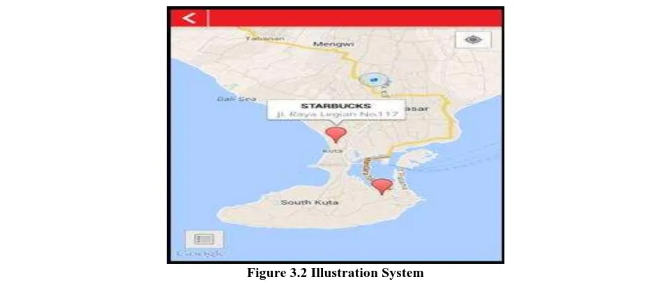
In the figure above is a system illustration which will be developed. In the system illustration can be seen the road map which is taken the platform from google maps. And it can be seen the marker colored in red.
If the marker is clicked then it will appear the information about Indonesia’s Wifi which containing the wifi’s name and wifi’s strategic location and address via info-window.
In this SIG design later it will display view menu. This menu later will display map of Bali and also display the
location which has been given a marking as a point location of Indonesia’s Wifi installed. Searching menu here
will display Wifi location which has been input and will display what to be searched. Blue marker will be the marker for the position of user. Guide button is useful to display the route which will be taken to search for Wifi
selected from user location at the moment. Detailed information button is about Indonesia’s Wifi.
IV.
RESULT
AND
DISCUSSION
4.1. Program Construction
SIG application of Indonesia’s Wifi based on Android is divided into two namely user interface and
admin interface. Admin interface consists of several parts such as executing an application, main menu, History, Game, Setting, Sign, and Credit. Menwhile on user interface consists of login user, sign-up user, main map display, map radius, info-window, detailed location and road sign. The following is the explanation and display from SIG application being constructed.
4.2. Admin Interface Application 4.2.1. Admin Login Display
To execute the admin interface, user can open the website: http://www.gme14.com/indonesiawifi. It will then display the admin login such as in figure 4.1. In the form of admin login, there is user name and password which must be filled by the admin.
Figure 4.1 Login Fom
4.2.2. Display of Admin Form
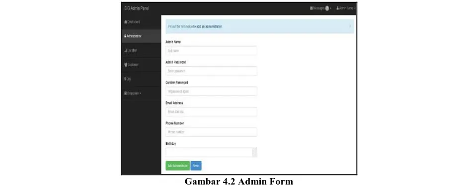
Below is the display after we click add administrator button in the previous part. Fill in the form below with the desired data. Then click Add Administrator button. If there is one of input data filled in is empty or wrong data format, then error message will automatically appear. The following is the display to enter Administrator data.
Geographic Information System of Indonesia’s Wifi Based on Android Platform
5
4.2.3. Display of Edit Admin FormThe display below is an edit administrator display. Choose administrator which will be edited then
choose “Edit” action. The editing process of administrator data also has been equipped with validation such as empty form or wrong data format and error message will automatically appear.
Figure 4.3 Edit Admin
4.2.4. Display of Delete Admin
After success to edit administrator, now we try to delete administrator. Choose the administrator to be deleted then in the menu action choose “Delete”. Then it will display as below.
Figure 4.4 Delete Admin 4.2.5. Display of Edit Location
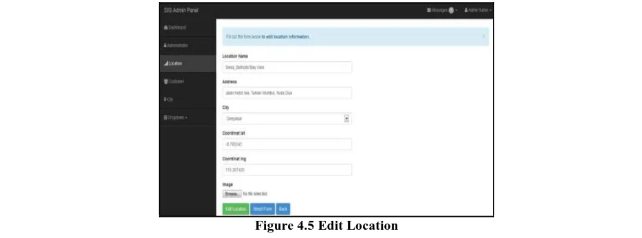
The display below is edit location display. Choose the location to be edited then choose action “Edit”.
Then the display will appear as below. The process of location data editing also has been equipped with validation such as empty form or wrong data format which will display error message automatically.
Geographic Information System of Indonesia’s Wifi Based on Android Platform
6
4.2.6. Display of Delete LocationBelow is the display when we want to delete location data, choose the location to be deleted then in the
menu Action choose “Delete”. So the display will appear as below.
Figure 4.6 Delete Location
4.3. User Interface Application 4.3.1. User Interface Display
In the user interface application, user will directly enter to login form. In the login form there are fields of user name and password. User is expected to fill in the field available. Then in the login form there are two buttons namely Sign In button and if the user does not have any account then he/she will be directed to Sign Up button. If in the android does not have packet data then in the program it will display the message No Internet Access. When the login is successful then the user will enter the map display and if the login fails then it will display the message wrong user name and password.
Figure 4.7 Sign Up 4.3.2. Sign Up
When entering Sign Up, user will directly heading to sign up form which requires the user to fill in all the fields available and it is not allowed to be empty. In the sign up, information required is in the form of user’s
complete name, date of birth, email, password, re-type password and user’s phone number. In which email and
Geographic Information System of Indonesia’s Wifi Based on Android Platform
7
Figure 4.8 Sign Up template 4.3.3. Maps
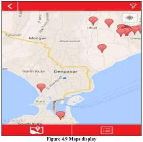
If the user has logged in then it will display program window as follows. In which red marker presents the location of Wifi ID position, whereas blue marker presents the position where the user stands. Next under the window there are two buttons in which the left button is the map button and right button is the list button.
Figure 4.9 Maps display 4.3.4. List
When the right button that is list button is touched then it will display the series of lists from the nearest
Geographic Information System of Indonesia’s Wifi Based on Android Platform
8
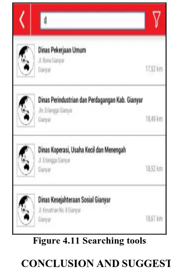
Figure 4.10 Form list display 4.3.5. Search
If in the previous form the user fills in the search field then automatically the program will directly searching for key words intended by the user. As for the display from the search menu is as follows.
Figure 4.11 Searching tools
V.
CONCLUSION
AND
SUGGESTION
5.1. Conclusion
From the elaboration result of previous chapters and analysis and design of Geographic Information
System of Indonesia’s Wifi based on Android at SARBAGITA areas being carried out, then it obtains several conclusions, among others:
1. This Geographic Information System is using Eclipse, MySQL, and PHP. In which Eclipse is used to establish android application, MySQL is used for database meanwhile PHP is used to design Admin Panel. 2. The system is designed to carry out insert, update, delete, and see detail operation data from the information
system.
3. The application can be used easily with its interface display, and can be carried around so that the user will feel comfortable.
Geographic Information System of Indonesia’s Wifi Based on Android Platform
9
5.2. SuggestionAfter establishing this system, several important suggestions are obtained in order to develop this system later. If later there is someone who wants to develop this application, there are several things have to be considered:
1. This sytem also can be applied on other mobile operating systems, such as Blackberry, iPhone or Windows
Phone.
2. This system can be developed in much wider area.
3. It is expected that the system can be developed offline so that when the server is disrupted, from the client side it will not be disrupted.
ACKNOWLEDGEMENTS
The appreciation is awarded to the members of this research team, along with all the colleagues who have given a lot of help both in discussion of ideas until the trial implementation stage of the device. Not forgotten also the appreciation is delivered to the Department of Electrical and Computer System Engineering Udayana University which has supported in lending the equipment laboratory in this research.
REFERENCES
[1]. Guy Harrison and Steven Feuerstein, 2006, MySQL Stored Procedure Programming: Building
High-Performance Web Applications in MySQL, ISBN: 978-0-596-10089-6, O'Reilly Publisher
[2]. Harahap, NS. 2013. Aplikasi berbasis Android Berbagai Implementasi dan Pengembangan Aplikasi Mobile berbasis Android. Informatika. Bandung.
[3]. Harjo, Misni. 2013. Sistem Informasi Geografis Fasilitas Umum Berbasis Android. Institut Sepuluh November. Surabaya
[4]. Sutrisno, EPA. 2013. Program Aplikasi Gps Dan Gis Untuk Mencari Lokasi Dan Jarak Spbu Di Tangerang Selatan Dengan Peta Dan Augmented Reality Camera-View Pada Perangkat Bergerak Berbasis Android. Universitas Gunadarma.
[5]. Zigurd Mednieks, Laird Dornin, G. Blake Meike, Masumi Nakamura, 2012, Programming Android,
2nd Edition, 978-1-44931-664-8, O'Reilly Publisher.
BIBLIOGRAPHY
OF
AUTHOR
Dr. Ir. Made Sudarma, M.A.Sc.
Department of Electrical and Computer System Engineering Faculty of Engineering, Udayana University
Bukit Jimbaran, Bali, Indonesia Tel./Fax : +62361703315