Meteorological analysis of the Banjarnegara Landslide
on 12 December 2014
Suaydhi* and Bambang Siswanto
Center for Atmospheric Science and Technology (PSTA), LAPAN, Jl. dr. Junjunan 133, Bandung 40173, Indonesia
Abstract
Hydro-meteorological disasters, such as floods and landslides, occur frequently in Indonesia. In the case of landslides, there are controlling and triggering factors. This paper analyzes the meteorological condition, which is the controlling factor to a landslide event. Observations and simulated data are used to analyze the meteorological condition prior the landslide event that occurred in Banjarnegara on 12 December 2014. This event took many casualties because there was no warning system available. The results of the analysis showed that prolonged heavy rainfall occurred days before the landslide event. Cumulonimbus clouds were also observed around Central Java. This cloud can be used as indication of heavy rainfall. However, observation of clouds can only valid for a very short time. Longer and at frequent interval weather forecasts are needed to see if the rainfall persists and has enough intensity to trigger a landslide. The analysis of this paper showed that a numerical model can simulate rainfall event considerably well. Therefore, simulation of rainfall forecast for 24 hours ahead from a numerical model can be used as early warning system to mitigate the impact of a landslide event.
Keywords Banjarnegara, cloud, early warning system, landslide, model, rainfall
1.
Introduction
A concise definition of landslide is the downward and outward gravitational displacement of slope-forming materials (Gutierrez et al., 2010). A more comprehensive definition of landslide, according to Agliardi (2012), is the mass movement of rock, soil, or debris material forming a natural or man-made slope towards the lower and external part of the slope, along a defined sliding surface. From the latter definition, it can be inferred that causes of landslides can be generally categorized into natural and anthropogenic factors. The natural factors include gravity, geological factor, meteorological factor, earthquakes, forest fire, volcanoes, and waves (Cruden & Varnes, 1996). The anthropogenic factors could be in the form of inappropriate drainage system, cutting and deep excavations on slopes, and change in slope/ land use pattern. The geological factor which describes the conditions of the Earth's surface can be considered as the controlling factor. The meteorological factor, which refers to events happening in the atmosphere, can be considered as the triggering factor. Both factors are important in the event of landslide.
Landslides mostly occur in rainy season in Indonesia, where there are a lot of heavy and prolonged rainfall. Landslide is a type of hydro-meteorological disasters. Between 2003 and
SWUP 2005 more than 50% of about 1429 disasters in Indonesia are related to hydro-meteorology, with landslide accounting for 16% (Bappenas & Bakornas PB, 2006). Therefore, analysis of the meteorological factor on a landslide event is as important as analysing the geological factor. An accurate prediction of the weather on sites that are prone to landslide can save property as well as human lives considerably.
Banjarnegara is surrounded by mountains and hills. The area has high rainfall records, especially during the rainy season. These features make Banjarnegara vulnerable to landslides. There have been 22 landslide events in Banjarnegara between 2005 and 2014 (Firdaus, 2014). The latest landslide in Banjarnegara is one of many such events in Indonesia that had many casualties. A landslide event is difficult to predict. One way to mitigate the impact of a landslide is to identify the meteorological condition, as variations in rainfall and potential evaporations control indirectly control the initiation and movement of a landslide occurrence (Coe & Godt, 2012). In Sipayung et al. (2014), landslide is triggered by the rainfall accumulation 15 days and 3 days before the event. This paper presents the analysis of the meteorological condition before the landslide in Banjarnegara that occurred on 12 December 2014.
2.
Data and method
2.1
Data
This paper uses data from observations and model outputs. Rainfall observations are taken from the Climate Prediction Center (CPC) National Oceanic and Atmospheric Administration (NOAA) in the form of CMORPH (CPC MORPHing technique) data (Joyce et al., 2004). Cloud observations are derived from the second generation of Multi-functional Transport Satellite (MTSAT2), while the low-level wind fields are extracted from reanalysis data. CMORPH data are derived from low orbiter satellite microwave observations. The precipitation estimates of CMORPH are generated from the combination of existing microwave rainfall algorithms. CMORPH data incorporate precipitation estimates from several different satellites. The CMORPH data used in this paper have temporal resolution of 3 hours and spatial resolution of 0.25 degrees.
MTSAT2 is a geostationary satellite, which means it is located fixed above some position on the Earth's surface. MTSAT2 is positioned 35,800 km above equator at 145⁰E. This satellite is intended to improve the meteorological services, such as weather forecasts, natural-disaster countermeasures, and securing safe transportation, covering East Asia and the Western Pacific Region. It has five channels, four in the infrared regimes and one channel in the visible spectrum. In this paper, data from the first and second infrared channels (IR1 and IR2) are used to derive the cloud types. These infrared data have a temporal resolution of one hour and a spatial resolution of 5 km.
Results from the outputs of a climate model are also used in this paper. The simulation is used to show the heavy rainfall that hit Karangkobar area in Banjarnegara around the time of the landslide event. The model used for the simulation of the atmospheric condition is the quasi-uniform Conformal-Cubic Atmospheric Model, known as C-CAM (McGregor & Dix, 2008). C-CAM is a hydrostatic model with two-time-level semi-implicit time differencing, employing semi-Lagrangian advection with bicubic horizontal interpolation on unstaggered grid. It can be used to simulate a specific region with high resolution (for example: 5 km x 5 km), while a coarser grids are used outside that region.
2.2
Method
The brightness variations obtained from the sensors of MTSAT are converted to the equivalent blackbody temperatures on the top of clouds using a calibration scale provided by the Japan Meteorological Agency (JMA) as the owner of the satellite. A two-dimensional threshold diagram (2d-THR) from Suseno & Yamada (2012) is used to classify the cloud type. Using this method the cumulonimbus cloud is identified. Cumulonimbus is a cloud type that is associated to a heavy rainfall.
3.
Results and discussion
The rainfall time series from CMORPH in Banjarnegara area leading to the landslide on 12 December 2014 is shown in Figure 1. The CMORPH data are in 3-hour interval. It can be seen from that figure that there had been heavy rainfall in Banjarnegara area days before the landslide disaster struck the Karangkobar sub-district, in particular on the 4th and 11th December 2014. This is in agreement with Sipayung et al. (2014) that landslide is triggered by a threshold of rainfall accumulation 15 days and 3 days before the event.
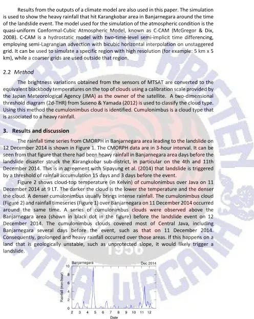
Figure 2 shows cloud-top temperature (in Kelvin) of cumulonimbus over Java on 11 December 2014 at 9 LT. The darker the cloud is the lower the temperature and the denser the cloud. A denser cumulonimbus usually brings intense rainfall. The cumulonimbus cloud (Figure 2) and rainfall timeseries (Figure 1) over Banjarnegara on 11 December 2014 occurred around the same time. A series of cumulonimbus clouds were observed above the Banjarnegara area (shown in black dot in the figure) before the landslide event on 12 December 2014. The cumulonimbus clouds covered most of Central Java, including Banjarnegara several days before the event, such as that on 11 December 2014. Consequently, prolonged and heavy rainfall occurred over those areas. If this happens on a land that is geologically unstable, such as unprotected slope, it would likely trigger a landslide.
SWUP Figure 2. Cloud-top temperature (K) of cumulonimbus over Java on 11 December 2014 at 9 LT. The black dot indicates Banjarnegara area.
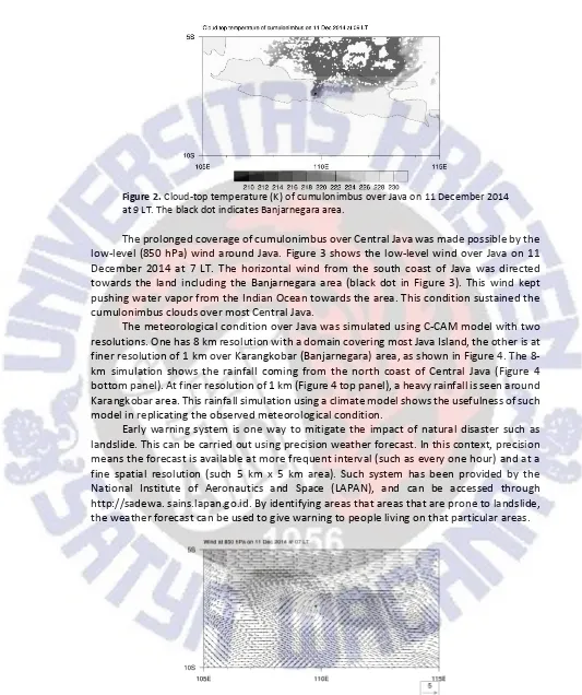
The prolonged coverage of cumulonimbus over Central Java was made possible by the low-level (850 hPa) wind around Java. Figure 3 shows the low-level wind over Java on 11 December 2014 at 7 LT. The horizontal wind from the south coast of Java was directed towards the land including the Banjarnegara area (black dot in Figure 3). This wind kept pushing water vapor from the Indian Ocean towards the area. This condition sustained the cumulonimbus clouds over most Central Java.
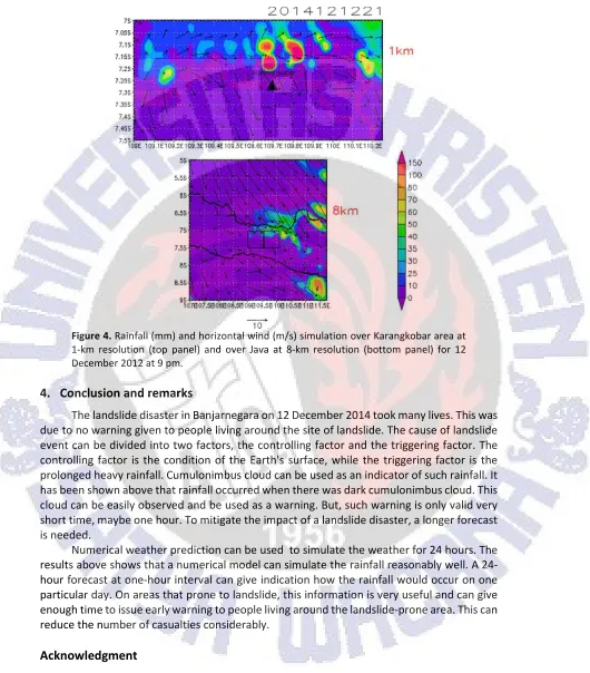
The meteorological condition over Java was simulated using C-CAM model with two resolutions. One has 8 km resolution with a domain covering most Java Island, the other is at finer resolution of 1 km over Karangkobar (Banjarnegara) area, as shown in Figure 4. The 8-km simulation shows the rainfall coming from the north coast of Central Java (Figure 4 bottom panel). At finer resolution of 1 km (Figure 4 top panel), a heavy rainfall is seen around Karangkobar area. This rainfall simulation using a climate model shows the usefulness of such model in replicating the observed meteorological condition.
Early warning system is one way to mitigate the impact of natural disaster such as landslide. This can be carried out using precision weather forecast. In this context, precision means the forecast is available at more frequent interval (such as every one hour) and at a fine spatial resolution (such 5 km x 5 km area). Such system has been provided by the National Institute of Aeronautics and Space (LAPAN), and can be accessed through http://sadewa. sains.lapan.go.id. By identifying areas that areas that are prone to landslide, the weather forecast can be used to give warning to people living on that particular areas.
Figure 4. Rainfall (mm) and horizontal wind (m/s) simulation over Karangkobar area at 1-km resolution (top panel) and over Java at 8-km resolution (bottom panel) for 12 December 2012 at 9 pm.
4.
Conclusion and remarks
The landslide disaster in Banjarnegara on 12 December 2014 took many lives. This was due to no warning given to people living around the site of landslide. The cause of landslide event can be divided into two factors, the controlling factor and the triggering factor. The controlling factor is the condition of the Earth's surface, while the triggering factor is the prolonged heavy rainfall. Cumulonimbus cloud can be used as an indicator of such rainfall. It has been shown above that rainfall occurred when there was dark cumulonimbus cloud. This cloud can be easily observed and be used as a warning. But, such warning is only valid very short time, maybe one hour. To mitigate the impact of a landslide disaster, a longer forecast is needed.
Numerical weather prediction can be used to simulate the weather for 24 hours. The results above shows that a numerical model can simulate the rainfall reasonably well. A 24-hour forecast at one-24-hour interval can give indication how the rainfall would occur on one particular day. On areas that prone to landslide, this information is very useful and can give enough time to issue early warning to people living around the landslide-prone area. This can reduce the number of casualties considerably.
Acknowledgment
SWUP
References
Agliardi, F. (2012). Landslides: definitions, classification, causes, in Alpine rock slope failures: mechanisms, controls, characterization. Czech Geological Survey - Geological Survey of Austria - UNIMIB Educational Project Geological Field Trip and Workshop.
Bappenas & Bakornas PB, (2006). Rencana aksi nasional pengurangan resiko bencana 2006-2009. Perum Percetakan Negara RI.
Coe, J.A., & Godt, J.W. (2012). Review of approaches for assessing the impact of climate change on landslide hazards, Landslides and Engineered Slopes, Protecting Society through Improved Understanding (Eds. E. Eberhardt, C. Froese, A.K. Turner, and S. Leroueil). Proceeding of the 11th International and 2nd North American Symposium on Landslides and Engineered Slopes, Banff, Canada, 3-8 June, Taylor & Francis Group, London, 371–377.
Cruden, D.M., & Varnes, D.J. (1996). Landslide types and processes, in Landslides Investigation and Mitigation (Eds. A.K. Turner and R.L. Schuster), Transportation Research Board, US National Research Council. Special Report 247, Washington, DC, 36–75.
Dee, D.P. (2011). The ERA-Interim reanalysis: configuration and performance of the data assimilation system. Quarterly Journal of the Royal Meteorological Society, 137, 553–597.
Firdaus, E. (2014). Mencemaskan! Frekuensi Bencana Longsor dari Tahun ke Tahun Terus Meningkat, Inilah Datanya. Tribunnews.com, accessed on 30 May 2015.
Gutierrez, F., Soldati, M., Audemard, F., & Balteanu, D. (2010). Recent advances in landslide investigation: Issues and perspectives. Geomorphology, 124, 95–101.
Joyce, R.J., Janowiak, J.E., Arkin, P.A., & Xie, P. (2004). A method that produces global precipitation estimates from passive microwave and infrared data at high spatial and temporal resolution. Journal of Hydrometeorology, 5, 487–503.
McGregor, J.L., & Dix, M.R. (2008). An updated description of the conformal-cubic atmospheric model. In high resolution numerical modelling of the atmosphere and ocean (Eds. K. Hamilton and W. Ohfuchi), Springer, 51–75.
Sipayung, S.B., Cholianawati, N., Susanti, I., Rahayu, S.A., & Maryadi, E. (2014). Pengembangan model persamaan empiris dalam memprediksi terjadinya longsor di daerah aliran sungai (DAS) Citarum (Jawa Barat) berbasis data satelit TRMM. Jurnal Sains Dirgantara, 12(1), 12–21.