J Trop Soils, Vol. 20, No. 1, 2016: 27-32 DOI: 10.5400/jts.2016.21.1.27
J Trop Soils, Vol. 21, No. 1, 2016: 27-32 ISSN 0852-257X
Characterization of Several Paddy Soil Types in Bogor,
West Java, Indonesia
Kurniati, Sudarsono and Suwardi
Department of Soil Science and Land Resource, Bogor Agricultural University Bogor 16680, Indonesia, e-mail: [email protected]
Received 23 October 2015/ accepted 04 January 2016
ABSTRACT
Paddy soil has different morphology and pedogenic characteristics compared to dry land, due to the influence of inundation during several months in a year. Puddling and drying that occurs in turns (redox cycle) in paddy soil can lead to the formation of concretions or rusty Fe and Mn. The main purpose of this study was to understand the changing of the morphological and chemical properties as a result of changing of the dry land to paddy soil. Besides, the study also aimed to understand plow pan layer formation in Podsolic, Latosol, Regosol, and Andosol soil type. Results showed that content of soil density (bulk density) of dry land ranged from 0.5 to 1.0, while paddy soil is 0.8 to 1.0 (g cm-3). Bulk density values in all four types of soils increased after the changing. Observation also
demonstrated that severity levels of paddy soil is higher than dry land, especially in the second and third soil layers or under the surface of soils. Acidity of dry land was likely to be higher than paddy soil. There were no significant differences in nutrient such as C-organic, P and N. Meanwhile, using dithionite as solvent, paddy soil has higher Fe, Mn, and Al content than that of dry land, and remain the same when extracted with pyrophosphate and oxalate. From the four types of soil observed,the paddy soil showed formation of plow pan layer. This was shown by the soil severity level higher than the topsoil or other layers. Paddy soil had unique properties due to redox reaction, thereby providing soil discoloration i.e darker due to high solubility of Fe, Mn, and Al.
Keywords: Concretion of Fe and Mn, paddy soil, pedogenesis, plow pan layer
ABSTRAK
Tanah sawah mempunyai sifat morfologik dan pedogenik yang berbeda dibandingkan dengan tanah yang tidak disawahkan, akibat pengaruh penggenangan selama beberapa bulan dalam satu tahun. Penggenangan dan pengeringan yang terjadi secara silih berganti (siklus oksidasi-reduksi) pada tanah sawah dapat menimbulkan terbentuknya konkresi atau karatan besi (Fe) dan mangan (Mn). Tujuan dari penelitian ini adalah untuk mempelajari perubahan sifat-sifat morfologi, dan kimia akibat perubahan lingkungan lahan kering menjadi tanah sawah serta mempelajari pembentukan lapisan tapak bajak pada jenis tanah Podsolik, Latosol, Regosol, dan Andosol. Hasil penelitian menunjukkan bahwa kerapatan isi tanah (bulk density), tanah yang tidak disawahkan memiliki nilai yang
berkisar antara 0,5 – 1,0 g cm-3, sedangkan tanah yang disawahkan mengalami peningkatan yaitu 0,8 – 1,0 g cm-3.
Peningkatan nilai bulk density terjadi pada keempat jenis tanah yang diteliti. Hal ini juga dibuktikan pada saat pengamatan di lapangan menunjukkan bahwa tingkat kekerasan tanah sawah jauh lebih tinggi dibandingkan dengan tanah yang tidak disawahkan, utamanya pada lapisan tanah ke-2 dan ke-3 atau di bawah lapisan olah. pH tanah yang disawahkan cenderung lebih tinggi dibandingkan pH tanah yang tidak disawahkan. Tidak ada perbedaan yang signifikan pada unsur hara yang lain seperti C-organik, fosfor dan nitrogen. Sementara kandungan Fe, Mn dan Al yang diekstrak dengan dithionit mengalami peningkatan pada tanah sawah dibandingkan tanah yang tidak disawahkan begitu pula yang diekstrak dengan Pirofosfat dan oksalat, cenderung lebih tinggi dibandingkan dengan tanah yang tidak disawahkan. Pada keempat jenis tanah yang telah diamati dari tanah sawah memperlihatkan terbentuknya tapak bajak. Hal ini ditunjukkan dengan tingkat kekerasan tanahnya lebih tinggi dibandingkan dengan lapisan olah atau lapisan lainnya. Tanah sawah memiliki sifat yang khas dengan adanya proses reaksi oksidasi-reduksi sehingga memberikan perubahan warna tanah menjadi lebih gelap karena tingginya kelarutan Fe, Mn, dan Al. Selain itu pada tanah sawah terdapat lapisan tapak bajak yang terbentuk akibat proses pengolahan tanah.
INTRODUCTION
Paddy soil has different morphology and pedogenic characteristics than dry land, due to the influence of inundation during several months in a year (Kawaguchi and Kyuma 1977). Puddling and drying that occurs in turns (redox cycle) in paddy soil can lead to the formation of concretions or rusty Fe and Mn. Which are formed as a result of dissolved Fe and Mn during flooding (reduction) which is accumulated in B horizon. Furthermore, in the dry wetland (reoxidation), accumulation of these Fe and Mn will create crust called concretions or rusty. If the process occurs in long period of time, the plow pan will be found in paddy soil profile.
Under the topsoil, plow pan layer with compaction index of dense layer is higher compare to other layers. The thickness of this layer ranges between 5-10 cm, which lies between depth of 10 and 40 cm (Kanno 1978). This compaction is not only caused by utilization of the plow, but also by the presence of other factors such as the continuous flooding and redox cycles. This plow pan may be originated from eluviation A and illuviation B horizon or both (Sanchez 1993; Moormann and Van Breemen 1978).
Morphology and pedogenic characteristic in paddy soil, may pose problems for field crops, if the planting use a crop rotation system. As proposed by the Dei and Maeda (1973) that generally top layer of paddy soil (10-20 cm) has physical properties that are less good for growing field crops, because the structure are solid or angled and plates. Similarly, although plow pan layer has a positive effect on water management and paddy growth in wet land cultivation, but it is not appropriate if this wetland is used for cultivating field crops. Plow pan layer will adversely affect root growth and nutrient availability for field (crops).
Research about genesis, classification and properties of latosol type for several levels of groundwater depth in wetland conducted by Winoto (1985) found that strong reduction process in shallow ground water of paddy soil can be shown in whole cross-section of pedon, whereas deep groundwater of paddy soil only can show on the surface. Later research from Rayes (2000) about the characteristics, genesis and classification of paddy soil from Merapivolcanic materials, found that the morphology of paddy soil and dry land was different, the intensity of rice cultivation (duration of paddy soil inundated) within a year led to different on paddy soil morphology.
Based on the uniqueness contained in paddy soil, this study compared the differences in
characteristics of paddy soil and dry land by observing and analyzing the morphology and chemical properties. Later, this study also classified them using Soil Taxonomy 2014.
MATERIALS AND METHODS Study Sites
This research consisted of field and laboratory study. Field study was conducted in Bogor where wetland locations are mentioned (Dramaga, Jasinga, Sukamantri and Sindangbarang Sub-district) in previous studies and Bogor Soil Type map. Laboratory study (Soil Chemical Laboratory, IPB) was conducted to determine physical and chemical properties of soil. Both studies were conducted from March to August 2015.
Methods
This study was conducted in four stages: (1) selecting research locations, (2) profiling and observing soil profile, soil sampling, (3) analyzing physical and chemical property of soil samples and classifying the soil according to soil taxonomy system
soil samples were taken in these following locations
(Table 1) and (4) physical and chemical property analysis of soil samples. The physical and chemical properties of the samples were analyzed for every layer. The process of the analysis is listed (Table 2). Classifying the soil according to soil taxonomy system secondary, field, and laboratory data were analyzed using descriptive and quantitative methods. Then, the sample locations were classified according to soil taxonomy system (Soil Survey Staff 2014). The samples were then classified up to sub-group category.
RESULTS AND DISCUSSION
Based on laboratory analyses of some physical and chemical properties of land are presented Table 3 to Table 6
Soil Morphology
Generally, there is a difference of morphology, physical and chemical between paddy soil and dry land. Changes in morphology and physical include horizon land composition, structure, consistency, land bulk density and soil severity level. These changes are caused by presence of different soil processing and land designation.
Results from field observations indicated that the horizon composition of dry land was different from paddy soil. Dry land had A, B, and C
Table 1. Description of sampling location.
Table 2. Variable and Method of Soil Properties Analysis.
Table 3. Soil Physical and Chemical Properties in Dramaga.
D: Dithionite, O: Oxalic acid, P: Pyrophosphate
Depth (cm) Severity (kgcm-2) BI (gcm-3) pH (H2O) KB (%) Fe (%) Mn (%) Al (%) D O P D O P D O P Paddy soil 0-20 1.00 0.9 5.6 54.9 1.3 0.3 0.8 0.2 0.4 0.08 0.8 1.8 0.20 20-32 4.50 1.0 5.9 96.4 1.2 1.9 0.8 0.7 0.4 0.03 1.0 1.8 2.70 32-41 4.00 0.9 5.9 51.9 1.2 1.1 0.8 0.3 0.4 0.06 1.0 1.7 2.80 41-51 2.00 0.9 5.7 60.9 1.2 0.7 0.2 0.6 0.1 0.05 1.1 3.1 2.10 51-70 0.75 0.9 5.3 54.1 1.1 1.0 0.2 0.3 0.1 0.02 1.2 2.7 1.60 70-87 0.50 0.9 5.8 28.0 1.2 1.0 0.2 0.3 0.1 0.02 1.3 1.8 0.40 87-105 0.50 0.8 5.6 56.6 1.2 0.4 0.1 0.3 0.1 0.02 1.3 1.9 0.08 105-120 0.50 0.9 5.6 50.8 1.2 0.4 0,1 0.3 0.2 0.02 0.1 2.1 0.09 Dry land 0-20 0.50 0.7 5.3 43.3 1.1 1.1 1.1 0.2 1.10 0.02 1.2 2.3 1.3 20-42 1.50 1.0 4.5 41.4 1.1 0.9 0.7 0.2 1.10 0.20 1.1 2.3 0.7 42-64 0.50 0.8 4.5 27.0 1.1 0.6 0.4 0.2 1.10 0.20 1.2 2.8 0.5 64-80 0.25 0.8 4.5 20.0 1.1 0.7 0.4 0.2 1.10 0.01 1.2 1.6 1.0 80-110 0.55 0.8 4.5 14.9 1.1 0.9 0.6 0.2 0.03 0.01 1.3 1.6 0.6 110-160 0.50 0.9 4.4 31.5 1.2 1.4 0.3 0.2 0.05 0.01 0.1 1.7 0.8
Locations Paddy soil Dry land
Coordinates Village/Sub-Village Coordinates Village/Sub-Village Dramaga sub-district 6o 32'58,9 "LS -106o 43'50,3" BT Cikarawang Village, Carang Pulang Chief-Village 6o 32'44 , 3 "LS -106o 43'27,9" BT Cikarawan g Village, Carang Pulang Chief-Village
Jasinga sub -district
6o27'35,9 "LS -106o27'34,6" BT
Mayang Cikopo Village, Kampung Ranca Buntung
6o29'14,3 "LS -106o28'49,1" BT Sifak village. Sukamantri sub-district 6o 27'35,9 "LS -106o 27'34,6" BT in Sukamantri village, Tamanasari Sub-district 6o 39'17,9 "LS -106o 45'51,0" BT Sukamantri Village, Tamanasari Sub-district. Sindangbarang sub-district 6o37'13,7 "LS -106o45'47,9" BT
Ciomas Rahayu village, Sindangbarang Sub-District 6o35'20,9" LS-106o46'03,4" BT Sindangbarang Village (experimental garden, IPB).
No Variables Methods Equipment
1 Soil Hardness Penetrometers 2 Weight contents/ Bulk Density Gravimetric 3 pH (H2O) pH meters
4 Ca and Mg-dd (Reagent of NH4OAc 1 N pH 7,0) AAS
5 K and Na ( Reagent of NH4OAc 1 N pH 7,0) Flame photo meter
6 Fe, Mn and Al (Extraction of bicarbonate dithionite citrate, pyrophosphate and oxalic acid)
AAS
composition, while paddy soil had horizon composition of Apg, Adg, Bwg and Cg. Paddy soil was grayish whereas in dry land was reddish or
brown. In paddy soil, there was a horizon which was not found in dry land (Adg horizon or plow pan layer). The presence of plow pan layer in paddy
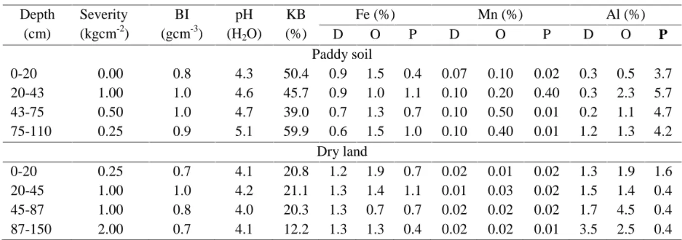
Table 4. Soil Physical and Chemical Properties in Jasinga. Depth (cm) Severity (kgcm-2) BI (gcm-3) pH (H2O) KB (%) Fe (%) Mn (%) Al (%) D O P D O P D O P Paddy soil 0-20 0.00 0.8 4.3 50.4 0.9 1.5 0.4 0.07 0.10 0.02 0.3 0.5 3.7 20-43 1.00 1.0 4.6 45.7 0.9 1.0 1.1 0.10 0.20 0.40 0.3 2.3 5.7 43-75 0.50 1.0 4.7 39.0 0.7 1.3 0.7 0.10 0.50 0.01 0.2 1.1 4.7 75-110 0.25 0.9 5.1 59.9 0.6 1.5 1.0 0.10 0.40 0.01 1.2 1.3 4.2 Dry land 0-20 0.25 0.7 4.1 20.8 1.2 1.9 0.7 0.02 0.01 0.02 1.3 1.9 1.6 20-45 1.00 1.0 4.2 21.1 1.3 1.4 1.1 0.01 0.03 0.02 1.5 1.4 0.4 45-87 1.00 0.8 4.0 20.3 1.3 0.7 0.7 0.02 0.02 0.02 1.7 4.5 0.4 87-150 2.00 0.7 4.1 12.2 1.3 1.3 0.4 0.02 0.02 0.01 3.5 2.5 0.4
D: Dithionit, O: Oxalic acid, P: Pyrophosphate
Table 5. Soil Physical and Chemical Properties in Sukamantri.
D: Dithionit, O: Oxalic acid, P: Pyrophosphate
Table 6. Soil Physical and Chemical Properties in Sindangbarang.
Depth (cm) Severity (kgcm-2) BI (gcm-3) pH (H2O) KB (%) Fe (%) Mn (%) Al (%) D O P D O P D O P Paddy soil 0-20 1.00 0.9 5.3 83.2 0.9 0.8 0.3 0.20 0.07 0.01 0.2 1.1 0.4 20-53 2.75 1.1 5.5 80.7 0.8 2.6 0.6 0.20 0.07 0.06 0.1 0.8 1.8 53-85 2.50 1.0 5.3 86.9 0.9 3.8 0.5 0.03 0.30 0.05 0.2 0.5 3.8 Dry land 0-30 1.25 0.9 4.6 34.1 1.1 3.5 1.5 0.10 0.20 0.10 0.3 0.7 5.7 30-60 1.00 0.8 4.9 37.8 0.7 0.7 0.6 0.10 0.02 0.05 0.2 2.7 2.3
D: Dithionit, O: Oxalic acid, P: Pyrophosphate
Table 7. Soil Classification based on Soil Taxonomy of Latosol and Podsolic.
Classification Latosol Podsolic Ordo Inceptisol Incep tisol Ultisol Ultisol Sub Ordo Udepts Aquepts Udults Aquults Great Group Dystrudets Epiaquepts Hapludults Epiaquults Sub groups Typic Distrudepts Typic Epiaquepts Inceptic Hapludults Typic Epiaquults Depth (cm) Severity (kgcm-2) BI (gcm-3) pH (H2O) KB (%) Fe (%) Mn (%) Al (%) D O P D O P D O P Paddy soil 0-18 1.50 0.8 5.1 42.1 1.1 1.3 0.6 0.10 0.10 0.02 3.1 1 5.0 0.6 18-50 3.50 0.9 4.9 37.2 1.2 1.4 0.4 0.10 0.10 0.20 3.1 1 6.0 0.7 Dry Land 0-34 0.25 0.7 4.6 5.30 1.3 1.5 0.5 0.10 0.01 0.04 2.8 1 6.0 0.3 34-49 1.50 0.7 3.9 8.60 1.4 0.7 0.2 0.20 0.01 0.02 1.3 1 1.0 0.2 49-66 1.50 0.6 4.6 8.90 0.7 0.6 0.2 0.02 0.10 0.03 1.7 1.6 0.5 66-86 1.50 0.7 4.6 13.80 0.7 0.9 0.4 0.10 0.10 0.10 0.3 5.7 1.3
soil were indicated by land severity level which was higher than the horizon above or below it. The severity value of soil in plow pan ranged from 2.75 to 4.5 kg cm-2. It was higher than topsoil and the
layer below it which ranged between 0-2.5 kg cm-2.
Also, the land bulk density value in the plow pan was higher than topsoil or layer below it. Bulk density value from plow pan ranged between 0.951-1.136 g cm-3. For all paddy soil profiles observed, the
presence of the plow pan can be found. This layer was formed due to puddling process which was occured repetitively during cultivation. It happened under the compaction of topsoil. Even, according to Munir (1987), plow pan formation caused by puddling during cultivation can be accelerated by using tractor during tilling rice field.
The soil color is a soil morphological characteristic that can clearly differentiate between one lands with another. Based on the results of morphological observation from both land, it showed that the dry land had brownish red color or even black. This was different with color of paddy soil which looks similar or closer to grayish. This was due to different soil condition during the growing season. Land that has been inundated tends to be grayish due to a process of dissolution of Fe and Mn. This was in line with Rayes (2000), in an inundated situation, the soil becomes gray as a result of the reduction of3+ to Fe2+.
Bulk Density
In general, bulk density of paddy soil had higher value than dry soil. In all paddy soil profiles observed, plow pan layer can be found below the topsoil, the bulk density value from this layer was higher than topsoil or layers below. This was due to puddling process during land cultivation. The high soil bulk density was further strengthening the presence or formation plow pan layer under topsoil. This was supported by Munir (1987) that the use of tractors for paddy soil cultivation can accelerate the formation of plow pan layer.
Soil pH
Based on the results of the analysis indicate that pH in paddy soil was higher than pH from dry
land. Flooded soil causes to increase bases solubility, so the concentration of H+ in the soil is reduced.
This is consistent with Hardjowigeno and Rayes (2000) that the flooding will cause all soil pH is approach 6.5 to 7.0, except in acidic peat land or soil with low levels of active Fe (Fe2+) in the soil.
Increasing the pH in acid soils as a result of flooding are controlled by system Fe2+ - Fe (OH) that
consumes H+. Flooding acidic soils is tantamount to
the calcification action itself causes the optimum pH range which allows optimum nutrient availability.
The Bases (Ca, Mg, Na, and K)
Overall analysis showed that exchange of bases in paddy soil was higher than dry land. The high content of these cations in paddy soil was caused by low leaching that occured as a result of presence of plow pan layer which inhibited water percolation, whereas in dry land number of bases cations were likely to be lower.
Base Saturation
Paddy soil had higher bases saturation than that of dry land. The high base saturation in paddy soil occured due to low leaching process and accumulation of base cations on the plow pan layer. This condition was in line with Munir (1987) whose recorded that the plow pan layer generally has a relatively higher base saturation than that of topsoil, since the number of cations such as Ca, Mg, K, Na, and other cations piled up above plow pan layer.
Fe, Mn and Al
Based on the determination of Al, Fe, and Mn with three different reagents it was shown that Fed and Mnd content was the highest, then followed by Feo and Mno and Fep and Mnp. While Alo was the highest then followed by Alp and Ald. Reagent Dithionite illustrates that in the soil, these three elements were in the form of oxide (crystal), while reagent sodium pyrophosphate showed that these elements were bound by organic matter, while reagent oxalic acid describes that Al, Fe, and Mn were bound by organic matter and amorphous minerals.
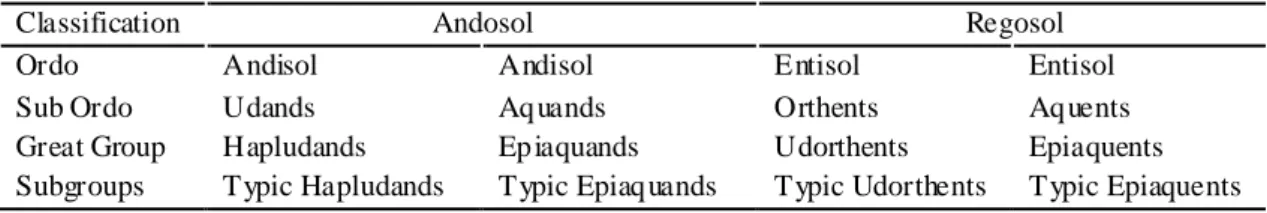
Table 8. Soil Classification based on Soil Taxonomy of Andosol and Regosol.
Classification Andosol Regosol Ordo Andisol Andisol Entisol Entisol Sub Ordo Udands Aq uands Orthents Aq uents Great Group Hapludands Ep iaquands Udorthents Epiaquents Subgroups Typic Hapludands Typic Epiaq uands Typic Udorthents Typic Epiaquents
Soil Classification
Overall classification of land by Soil Taxonomy are presented in the (Table 7). Generally, classification of the paddy soil is different from dry land. The difference starts at sub-order level. According to the condition from each soil, all paddy soil belongs to akuik sub-order, whereas dry land has various sub-order. Paddy soil belongs to akuik sub-order because it has akuik soil moisture regime. Akuik moisture regime is a layer below the epipedon or within 50 cm from the soil surface which is water saturated or flooded. It has a value of less than 2. At the level of Great Group, paddy soil classification describes the existence of episaturasi, namely akuik condition that occurs due to puddle from irrigation or not from the source of ground water itself. While for dry land at sub-order level shows that in all four types of soil moisture regimes has lout that is moist soil conditions.
CONCLUSIONS
It can be concluded that morphology of paddy soil and dry land was different in the presence of plow pan layer, as well as the physical and chemical properties, especially in the value of bulk density, pH, CEC and base saturations. These differences made the two types of soil fall into different classification up to the suborder category.
ACKNOWLEDGEMENTS
Thanks to Directorate General of Higher Education for the DIKTI scholarship Number 2117/ UN26/DT/2013.
REFERENCES
Dei Y and K Maeda. 1973. On soil stucture of plowed layer of paddy field. Japan Agric Res Quartely 7: 86-92. Hardjowigeno S and ML Rayes. 2001. Tanah sawah
[tesis]. Bogor (ID): Institut Pertanian Bogor. Kanno I. 1978. genesis of rice soils with special reference
to profile development. Soil and Rice. Los Banos (PH): IRRI Los Banos. pp. 237-254.
Kawaguchi K and K Kyuma. 1977. Paddy Soils in Tropical Asia. Hawaii (USA): University press of Hawaii. Moormann FR and NV Breemen. 1978. Rice, Soil, Water,
Land. Los Banos (PH): IRRI Los Banos.
Munir M. 1987. Pengaruh penyawahan terhadap morfologi pedogenesis, elektrokimia dan klasifikasi tanah [Disertasi]. Bogor: Institut Pertanian Bogor. (in Indonesian).
Rayes ML. 2000. Karakteristik, genesis, dan klasifikasi tanah sawah berasal dari bahan volkanik merapi. [Disertasi]. Bogor: Institut Pertanian Bogor. (in Indonesian).
Sanchez A. 1993. Sifat dan Pengelolaan Tanah Tropika. Jilid 2. Jayadinata JT, penerjemah. Bandung: Institut Teknologi Bandung. Terjemahan dari: Properties and Management of Soils in the Tropics. (in Indonesian).
Soil Survey Staff. 2014. Kunci Taksonomi Tanah. Edisi 12. Pusat Penelitian Tanah dan Agroklimat, penerjemah. Bogor (ID): Badan Penelitian dan Pengembangan Pertanian. Terjemahan dari: Keysto Soil Taxonomy. Twelfh Edition. (in Indonesian).
Winoto J. 1985. Genesis, klasifikasi dan sifat-sifat tanah sawah jenis Latosol pada beberapa tingkat kedalaman air tanah [Tesis]. Bogor: Institut Pertanian Bogor. (in Indonesian).
Yoshimitsu D and K Maeda. 1973.Onsoil structure of plowed layer of paddy field. Japan Agric Res Quartely. 7: 86-92