ID MAPPING DIRECTIC PERPUSTAKAAN UMP
1111 Iffi Iffi Iffi 1111 M ii llllI
ifi
TANG CAMPUS 0000103197
TINES KUMAR A/L PONNJAH CD1 1028
FACULTY OF COMPUTER SYSTEM AND SOFTWARE ENGINEERING
vi
ABSTRACT
At present, all universities in Malaysia only use the map to the destination as a 2D map as know as sign board. This is because all of the university campus is big campus and all the buildings or faculty positions are very far from one to one building on the other. Besides the increased cost to put signage on buildings. So, not all users of this 2D signage can reach to their destination building To solve this problem, I intend to provide a kiosk machine with 3D mapping system Direction at University Malaysia Pahang Campus Gambang
ABSTRAK
Pada masa mi, semua universiti di Malaysia hanya menggunakan peta untuk kedestinasi sebagai peta 2D sebagai papan tanda mi kerana semua kampus universiti adalah kampus yang besar dan semua bangunan atau kedudukan fakulti yang sangat jauh dari satu bangunan ke satu bangunan yang lain Selain itu kos untuk meletakkan papan tanda agak tinggi Jadi, tidak semua pengguna papan tanda 2D mi boleh sampai ke bangUnan destinasi mereka
.Untuk menyelesaikan masalah mi, saya bercadang untuk menyediakan mesin kiosk dengan 3D sistem pemetaan Arab di Universiti Malaysia Pahang Kampus Gambang
viii
EXECUTIVE SUMMARY
At present, all universities in Malaysia only use the map to the destination as a 2D map as know as sign board. This is because all of the university campus is big campus and all the buildings or faculty positions are very far from one to one building on the other. Besides the increased cost to put signage on buildings. So, not all users of this 2D signage can reach to their destination building To solve this problem, I intend to provide a kiosk machine with 3D mapping system Direction at University Malaysia Pahang Campus Gambang . My objective for this project is to develop a system that's cans show direction of University Malaysia Pahang, Gambang Campus in 3D to produce direction and the familiar surroundings of the University Malaysia Pahang , Gambang Campus for the first year student To design an under stable route map for new visitor to the University Malaysia Pahang Campus Gambang. My main target is a first year student , because they are difficult to find out the location of each building on this campus In addition, first-time visitor who comes to campus gambang is difficult to go their destination. SDLC continues to be selected because strategy to create it that's planning, analysis, design and development, testing and implementation. This methodology is usually selected as it tries to cut back built in undertaking risk by means of smashing some sort of undertaking in smaller sections, provides all too easy to transform throughout the development course of action and it's suited officially used on creating 3D Mapping Direction.
TABLE OF CONTENTS NAME PAGE DECLARATION SUPERVISOR'S DECLARATION iv ACKNOWLEDGMENTS v ABXTRACT vi ABSTRAK
EXECUTIVE SUMMARY viii
TABLE OF CONTENTS ix LIST OF TABLE x LIST OF FIGURE xi PART1 I INTRODUCTION PROBLEM STATEMENT 1 1.1 OBJECTIVE 2
1.2 REVIEW OF EXISTING SYSTEM 2
1.2.IZEBEDEE 3
1.2.2 GOOGLE MAPS 6
l.2.3BINGMAPS 9
1.3 RELATIONSHIP TO CURRENT PROJECT 11
1.4 CURRENT SYSTEM AND ITS LIMITATION 11
1.5 SCOPE 12
PART2 13
2.1 USER REQUIREMENT 13
2.2 FLOW CHART AND MATERIAL USED 14
2.3 METHOD AND MATERIAL USED 16
2.3.1 PLANNING 17 2.3.2 ANALYSIS 18 2.3.2.1 DETERMINING REQUIREMENT 18 2.3.2.2 STRUCTURING REQUREMENT 19 2,3.2.3 DESIGN STRTERGY 20 2.3.3 DESIGN DEVELOPMENT 20 2.3.3.1 DESIGN 20
2.3.3.2 DEVELOPMENT 20 2.3.3.3 INTERFACE DESIGN 21 2.3.4 IMPLEMENTATION 23 2.3.5 TESTING 23 3.0 DESIGN 23 4.0 CODING 24 REFERENCE 47 APPENDIX 48 LIST OF TABLE
TABLE NAME PAGE
1.1 Comparison with current system 11
2.1 List of User Requirement 13
2.3.2 Software Requirement 19
2.3.3 Hardware Requirement 19
LISt
OF 111UKEFIGURE NAME PAGE
Figure 1.1. (a) SHOW THE DEVICE 5
Figure 1.1. (b) THE METHOD OF USING 5
Figure 1.1. (c) THE OUTPUT RESULT 5
Figure 1.2. (a) SHOW FOR SEARCHING PARTICULAR MAPS
8
Figure 1.2. (b) SHOW THE MAPS ZOOM IN 8
Figure 1.3. (a) SHOW FOR SEARCHING PARTICULAR MAPS
10
Figure 1.3. (b) SHOW THE MAPS ZOOM IN 10
Figure 2.2.1 FLOW CHART OF MAIN FORM 14
Figure 2.2.2. CONTEXT OF DIAGRAM 3D MAPPING
14
Figure 2.2.3 FLOW CHART OF ADMIN 15
Figure 2.2.4 FLOWCHARTOFSTUDENT/VISITOR 15
Figure 2.2.5 DATA FLOW DIAGRAM 3D MAPPING
16
CYCLE
Figure 2.3.1 GANTT CHART 18
FIGURE 2.3.2.1 HOME PAGE 21
FIGURE 2.3.2.2 STUDENT PAGE 22
I
PART 1 INTRODUCTION
3D mapping, also called movie mapping in addition to spatial augmented fact, can be a projection technological innovation accustomed to turn objects, generally irregularly formed, right into a show exterior regarding movie projection. This kind of object might be difficult business landscapes, such as developing. By employing specialized application, a tow line or maybe 3d objects is usually spatially mapped for the electronic system that mimics the genuine surroundings that is usually to be expected with. It could interact with a projector to suit virtually any ideal image onto the symptoms of that object. This technique is used by means of musicians in addition to promoters likewise who is going to add extra proportions, optical illusions, in addition to ideas of movement onto recently static object. This movie is often along with, or maybe activated by means of, sound recording to build an audio-visual plot.
My main target is to build a kiosk machine in 3d mapping direction, in front of the main entrance of the UNIVERSITI MALAYSIA PAHANG, GAMBANG CAMPUS. Function of the kiosk machine 3d mapping direction is to show our direction in 3d. The purpose I choose this project title is to help the 1st year students in understanding the buildings location in UMP Gambang campus First year students often face difficult to locate buildings in the campus. Besides, visitors who visit the campus for the first time find it hard to locate their destination. With the help of 3d mapping direction kiosk machine they can easily identify the route to their destination.
PROBLEM STATEMENT
First year student of University Malaysia Pahang (UMP) having difficulties in locating their classes and important buildings in UMP. They often arrive late to classes because they unable to locate the correct location of their classes. In addition, visitors also having the same problem when they give a first visit to UMP. Therefore, a 3D mapping direction will help the students and visitors in locating their destinations. A 3D mapping direction kiosk machine will built in front of UMP entrance to help the students and visitors in UMP. The existing
buildings will be designed in 3D format using Auto Desk Maya software. A detailed route in campus will be included as well.
1.1 OBJECTIVE
i. To develop a system that can show direction of University Malaysia Pahang Campus Gambang in 3D
ii. To produce familiar the direction and surroundings of the University Malaysia Pahang Campus Gambang for first year student
iii. To design an under stable route map for new visitor to University Malaysia Pahang Campus Gambang
1.2 REVIEW OF EXISTING SYSTEM
The current system for 3d mapping direction here to assistance with giving ideas during the creation of the system. The information may be used to create an enhanced system. Pros and cons for the current system is going to be studied in order that the brand new system that developed.
Now, the applications that we are going to discuss are: i. Zebedee 3D Mapping
ii. Google Maps iii. Bing Maps
1.2.1 Zebedee
Get access to so that you can high-quality 3d images routes in the surroundings will surely guide improve options in addition to efficiency throughout the wide variety of programs. Up to now, It's already been tough to own 3d images routes Just like regular procedures both require cumbersome proportions, high priced laser beam scanners or simply additional recommendations similar to GPS DEVICE (Global Location System). CSIRO possesses altered just one world's initial light in weight, handheld 3d images laser beam mapping methods, Zebedee, that's self-contained in addition to isn't going to depend on additional positioning methods Straightforward so that you can utilize, Zebedee generates 3d images laser beam routes continuously, quickly, dependably, in addition to cost-effectively. The device can be meant for 3d images mapping programs having inside, subterranean as well as backyard conditions, much like locations earlier inaccessible to help greater deciphering equipment. Along with as opposed to wheeled portable methods, Zebedee will probably work from stairways in addition to hard landscape. The approach provides an distinctive combo with regards to portability, effective truth selection, accuracy and reliability within just areas without requiring GPS DEVICE, rapid deciphering related to large areas, as well as automatic information running.
FEATURES Portability:
The actual Zebedee technique performs quite well to help have a look at the majority of situations available to help folks, by simply stairways every single child smaller tunnels to help difficult land, of which are generally unavailable so that you can another 3d images mapping systems, including terrestrial scanning devices that happen to be mounted together with tripods, and also vehicle-mounted cell mapping systems.
Accuracy with areas without GPS:
Constructed from CSIRO's planet top robotics localization technological know-how, Zebedee positive aspects people surroundings themselves, somewhat when compared with external reference systems or even manufactured, so that you can simultaneously find your system together with chart people website. the flexibility will allow for Zebedee's used in inside, subterranean, together with insured situations, like forests, subterranean mines, and also processing facilities
Minimizes shadowing:
Because Zebedee can be a cell technique, materials on the surroundings are often seen by simply various view points, and thus lessening shadowing that develops because of occlusion.
Efficient data collection:
Zebedee automatically catches AND functions facts effortlessly ALONG WITH without the need of the complex build. your own period of time It requires to help chart an excellent surroundings may be the date You will require so that you can go walking through that. Tasks An item formerly essential many hours throughout existing products, may possibly right now become executed in mm's together with Zebedee. Facts is going to be quickly refined using the industry, offering appropriate comments towards -user which will certainly re-scan locations throughout not whole insurance policy coverage.
ac r!.. .
•1?)
I:j
pack Lchedc ;S• S piitg trfl MU S •- LII
55555 - t' j2T nj i z WE IOLai
ki4z
IL .-Ja4 ! Pat r1li-Mg . 41 — - , - -. .'- ,• 'S. it -' g - '..--...'" uI4' • ,hhI1"t .,-' I' •% - :-' __!lt - -'S 1_•.pl :innovation current simply by YAHOO AND GOOGLE, energizing several map-based providers, including Yahoo Atlases internet site, Yahoo Practical knowledge Locater, Goggle Transit in addition to road directions introduced upon third-party web sites by way of your Yahoo Atlases gives stop road directions in addition to a journey advisor for going simply by foot or so or possibly even longer, auto, cycle as well as acquiring open public move, additionally, it add a locator for city organizations in numerous international locations in the world. Yahoo road directions satellite television image typically are not renovate instantly. Yahoo has contributed information on their Principal Databases often, a lot of the image are frequently only four years aged.
FEATURES . Map Views
Your own Google Maps web site provides several map views that you should button between counting on ones needs. As well as switching by a great normal map for you to satellite imagery, YouVll overlay terrain information towards the normal map. You will additionally utilize Street see feature to acquire a panoramic look at of any buildings AND areas surrounding a good Private street, which might be put together via photographs accepted with street level from specially equipped cars.
• Directions
Enter two as well as extra distinct locations in your current Google Maps internet site to have driving, walking AND ALSO cycling directions to its many hassle-free routes. relying on the area youVre interested in, established. transport directions in addition could be available, no matter whether a lot of possible routes exist, You will Visit the summary associated with each that has a rough estimate of the date The item each route would acquire
. Customs Maps
Using Google Maps, anyone can cause a good custom map pertaining to any location, adding area marks, lines in additional to shapes to it, in additional to save the item in order to the Google account. You will populate the saved map on virtually any time, art print This out to the reference and also share a good Associate in order to It in others. the makes the Google Maps website the handy tool to be able to plan a good holiday as wellas a Simply click to be able to a new city
. Additional Information
Depending towards the place you are interested in, Google Maps will certainly give the excess specifics You might obtain useful, similar to current traffic load, road run and also road closures, photos involving areas and also landmarks, nearby webcams, as well as weather forecasts. if a person search for its place of the business, Google Maps will probably give the you having a general rating as well as reports involving That business as well as a Relate on the businesses website, regardless of whether one exists.
Accessibility
The Google Maps site relies from downloading as well as displaying large images. since involving this, It may load slowly or even not in just about all whether an individual have a connection It is limited in speed. Similarly, the web page will probably perform poorly or not on just about all whether viewed at a great browser That is not fully updated or maybe regardless of whether Java is actually not updated.
Figure 1.2. (a)
Ind-GO*M.F .-.-.-- ---.- .----...---.--.---....
4- C di ht1p!/map s.9009e.cQn .,
GoogIe India . .
Get dl,eCt,OflI My plates e 'no 4
O,.gI.M.t. .t 4G,tgI. .rty,.yaLls..py,ev
15! M.hfl Agas ill. -
4- * C ô nip,' fmaps gonqie non .,
cog,81e raj Ma gI ,n'o 0gB' Pradesh Ird
14 • _________ OFT
9
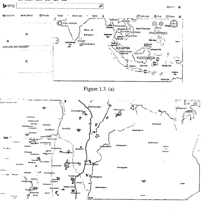
I Id TajMahal +91562226431 tarmshaigminFigure 1.2. (a) SHOW FOR SEARCHING PARTICULAR MAPS, (b) SHOW THE MAPS ZOOM IN
1.2.3 Bing Maps
Bing Maps directions has been depending on active Microsoft company technologies for instance Microsoft company MapPoint, and also TerraServer. The first type was lacking the majority of the differentiating features, including gulls eyesight view and also 3 dimensional map, and also the Selections performance has been on a sole of level of awareness.
FEATURES
Maps for mobile device
Get cellular telephone request obtaining pics optimized product or service (including iPhone). That attributes usually are known inside of Yahoo and Google Routes Internet Remedies.
Photosynthetic
Change a digital picture inside a breathtaking information which will present the specific major bio, with the essentials.
• Localized Maps and Directions
Find localized and also taking walks method inside of 15 language, and localized inside of Western Europe inside of Language, This terminology Spanish language. The actual the German language terminology, Colonial and Italian.
WEFi IMfWSS AIIWOS NEWS MAPS MORE
to bngf -
OuecSOflS *My places Nearby - thrO'scVye Tragic j
Malayta 8yAf \ ,f EXPLORE EIAPIMAGERY G.SF L: I fl : ?•- -.
•8FngkoI 1 \CA,,., ,, •M,n,I
\ —: '°".VE1NAF1 PHILIPPINES P,&, F.,., - .,.MALAYSA K,sI. Lumpur - ... INDONESIA—" 'V. -VV S.,, KA,,dN 4n - — WmOr S.a 10 Figure 1.3. (a) — \ \ S.GA G.ndp,, - . K d.1 tn
frf
I
/ IGnn /IyV...n.A SafldnnS II,,I t GNJF,,,' N I • 'GA'Arn ' h n,y"!" - - flntI,Fi.',n,jia ,iISL'y, — — GAS. ,,. n'G4 V '. ?-* Inb.(n. 'V.— -"V.-,--- Figure 1.3. (b)
Figure 1.3. (a) SHOW FOR SEARCHING PARTICULAR MAPS, (b) SHOW THE MAPS ZOOM IN
1.3 RELATIONSHIP TO CURRENT PROJECT
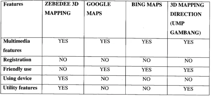
Table 1.1: Show The Comparison with current system
Features ZEBEDEE 3D GOOGLE BING MAPS 3D MAPPING
MAPPING MAPS DIRECTION
(UMP
GAMBANG)
Multimedia YES YES YES YES
features
Registration NO NO NO NO
Friendly use NO YES YES YES
Using device YES NO NO NO
Utility features YES NO NO YES
1.4 CURRENT SYSTEM AND ITS LIMITATION
This system to be developed to 3D Mapping University Malaysia Pahang Campus Gambang. The idea was developed as a survey showed that over 70 % of the first year student states that they are difficult to understand the location of the building locate in Campus Gambang. This is because the size of University Malaysia Pahang Campus Gambang very huge almost 5 hector. With this system, it is easy to help students in one or a new visitor who enters first time into Campus Gambang.
This system has several important features. This system not only direct but it will lead the distance and calculate the time taken to reach the destination selected. It has 3 options reaches his destination, which are by using car, motorcycles or walking. For this project, I use Auto Desk Maya Software. With using this software, it can create building as existing buildings on the campus of University Malaysia Pahang To use the system in not difficult. This system easily understandable by consumers would not even have the experience of how to use. This system is friendly user.
Even though the cost to develop the system in 3d mapping direction is not very high compared to using a map folder in hand 21), 3D mapping system is much easier to understand. It will indicate the direction exactly once. Consumers just need to see and understand only animation in 3d
1.5 SCOPE
Overall scope of the project is to develop a system of a kiosk machine which functions to help the users to identify the location of specified building from certain location, the distance of their destination from the main entrance ump of the user, and the required time to reach the destination. The limitation of design is the existing building in campus Gambang. This system just points the direction until the entrance of the building only. In order to complete this project, existing buildings in UMP Gambang will be specially designed in 3D format. Auto Desk Maya software can be used to design the existing buildings in 3D. Each and every single route in the campus will be included in detail in the system. This kiosk is user friendly. The user just needs to choose a destination. The kiosk will immediately show the route to the destination graphically. 3D formatted building design for a better understanding of the route to the location chosen.
13
PART 2
REPORT BODY 2.1 USER REQUIREMENT
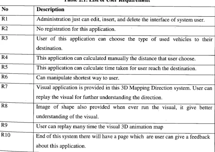
31) MAPPING DIRECTION will probably be developed while using user requirements. 10 individual requirements regarded as a feature which should included. The stakeholder linked to 3D Mapping Direction is usually to help first year student and new visitor who visit University Malaysia Pahang will get very well understanding road map. The consumer requirements are usually listed seeing that below throughout Table 2. 1.
3D MAPPING DIRECTION will probably be developed based on the user prerequisites. 20 user requirements regarded as a feature which should included. The stakeholder associated with 3D Mapping Direction is to help first year student get well understanding road in campus Gambang University Malaysia Pahang. The user requirements are listed as below in Table 2.1.
Table 2.1: List of User Requirement
No Description
Ri Administration just can edit, insert, and delete the interface of system user. R2 No registration for this application.
R3 User of this application can choose the type of used vehicles to their destination.
R4 This application can calculated manually the distance that user choose. R5 This application can calculate time taken for user reach the destination. R6 Can manipulate shortest way to user.
R7 Visual application is provided in this 3D Mapping Direction system. User can replay the visual for further understanding the direction.
R8 Image of shape also provided when ever run the visual, it give better understanding of the visual.
R9 User can replay many time the visual 3D animation map
RiO End of this system there will have a page which are user can give a feedback about this application.
2.2 FLOW CHART/CONTEXT DIAGRAMJDFD LEVEL 1
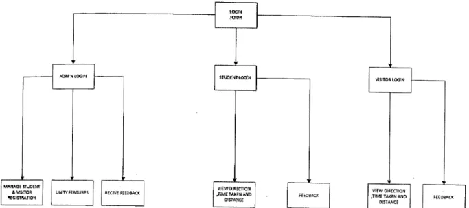
Figure 2.2.1. Flow chart of main form
ADMINISTOR
I-T
EDIT UPLOAD 1
IEEDBACE
VI PIN MAP 0 I
STUDENT 30 MAPPING ... VISITOR ON SEND FEEDBfCfZ
SEND FEEDBACK DIRECTION
14
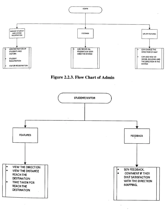
ADMVI
MANAGE STUDENT
AN VIS ITOR VEED3AK UTILITYFEATURES
REGS1YATON
ADMINISTRATION OF I I. CAN RECIVEALL CAN CHANGE THE
STUDENTS AND I FEEDACE:BYUSER I DIRECTION OMAP
VISITORS I I I USED THE SYSTEM I I I
I I I I I I. CAN ADD NEW 3D
STUDENT
I MODEL BUILDING AND
REGISTRATION I I I I I I I I THE DIRECTION IN 1515
I I SYSTEM
VISITOR REGISTRATION I I
Figure 2.2.3. Flow Chart of Admin
1UDEr1TM5rroR
FEATURES I FEEDBACK
VIEW THE DIRECTION
VIEW THE DISTANCE • SE cffDBACK.
REACH THE a COMMENT IF THEY
DESTINATION DINT SATISFACTION
TIME TAKEN FOR WITH THE DIRECTION
REACH THE MAPPING.
DESTINATION
15
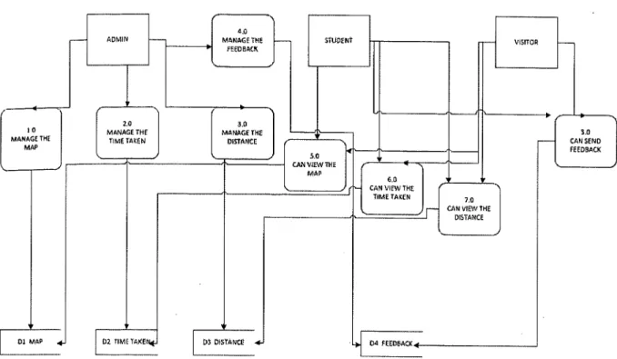
Figure 2.2.5. Data Flow Diagram of 3D MAPPING
2.3 METHOD AND MATERIALS USED
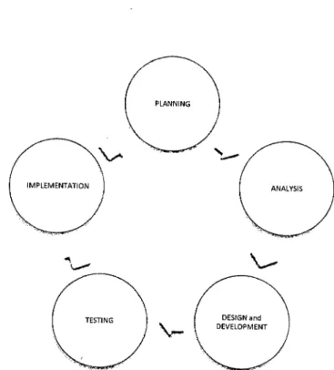
For develop 3D Mapping Direction, I'm using the process System Development Life CYC1e(SDLC).SDLC is usually a method used to analysis or perhaps method creator to formulate a fact method creator to formulate a fact method. Step one is a planning which are we need to organizing the system scope and data flow. Step two is analysis. For this step we need to evaluation for customer requirement. Step three is design and development. In this step need to pattern the system wt requirement. Step four is testing or knows as assessment. Step five is implementations which are final step to rendering. SDLC has primary aims, which are to ensure that high quality systems supplied, provide strong management controls on the projects as well as maximize productivity from the system. Quite simply, the SDLC Should make sure we could produce a lot more function, with higher quality, in fewer time, with fewer resource and inside a predictable way.
PLANNING
U
IMPLEMENTATION
ANALYSIS
TESTING
DESIGN
Figure 2.3. System Development of Cycle
2.3.1 Planning
Initial step in System Development Life Cycle (SDLC) is setting up cycle that function regarding distinguish this range on the task and experience a timetable to be able to allot sources. Preparing cycle will make certain a system complete details technique need are generally that are identifying dilemma, brainstorming of suggestion, produce a time table with the task and start this task. The first dilemma is that the visitor facing complications learning the particular setting in the educational institutions specifically parents. The second dilemma is pupils find it difficult to allocate lecturer office or certain management office. Third dilemma will probably be that the guidance demonstrated intended for visitors in addition to student will not be affective to allow them to offer a suitable direction. The task feasibility is proved by simply doing investigation in web in addition to present handbook methods in contrast with present methods. In the event the comparison is conducted with the present method, methods to fix the situation were found out to come UP with an effective method. A Gantt chart is generated to help program the job in addition to allocate the particular methods. Ultimately the particular task is presented good Gantt chart that will generated for reference.

