SUPPORTING STUDENTS’ UNDERSTANDING ON SPECIFYING THE
LOCATION OF POINTS USING CARTESIAN COORDINATE SYSTEM
Laurado Rindira Sabatini1, Ratu Ilma Indra Putri2, Yusuf Hartono3
Srwijaya University1,2,3
[email protected], [email protected]2, [email protected]3,
Abstract
The Cartesian coordinate system plays an important role for children either at school or in their daily lives such as graph work and map reading. Signifying that importance, however, the Cartesian coordinate is commonly introduced as a ready-made system that leads to a
lack of students’ understanding because they are merely asked to remember the rule and
the notation. For this reason, a set of instructional activities are essentially needed to have students encounter and understand the concet by themselves. In the current study, design research is chosen as a study approach and the instructional activities are designed based on realistic mathematics education (RME) theory. This study involves four students of grade 5 in SD Pusri Palembang, Indonesia. The results show that students were able to specify the location of points on the positive quadrant of the Cartesian plane by using the ordered pairs. In addition, they were able to describe the location of points, which has zero and/or half as one of its numerical coordinate. This shows that the designed-learning can support students’ understanding in specifying the location of points on the positive quadrant of the Cartesian coordinate system.
Keywords: Cartesian coordinate system, RME, design research, an ordered pairs
INTRODUCTION
The Cartesian coordinate system has important role for the ability of map reading and
graph’ works (Somerville & Bryant, 1985; Blades & Spencer, 2001). Signifying this issue, however, the Cartesian coordinate is frequently introduced as a ready-made system that leads to lack of understanding. For instance, children are merely asked to remember the rule and the notation about an ordered pairs to identify the location of a certain point in the Cartesian plane (Palupi, 2013). Additionally, most of mathematics textbooks in Indonesia are full of rules or algorithms and lack of applications (Zulkardi, 2002).
Without deep understanding, children potentially have difficulty to work with the tasks related to the Cartesian system (Clements & Sarama, 2009). For instance, Sarama, Clements, Swaminathan, McMillen, & Gomez (2003) argued that children tend to reverse the value of x and y when being asked to describe the location of points by using the ordered pairs (x, y). Working with the coordinate that has zero as one of its coordinate also leads to a problem (Sarama & Clements, 2003). Here, when being asked to locate a point along the x-axis, they do not describe the point at (x, 0), but at (x, 0). It is also happened for a point on the y-axis
Spencer, 2001). However, there is surprisingly limited study about designing instructional units related to the use of coordinate system that is applicable in the practical situation (Palupi, 2013). Therefore, this study offers a set of instructional activities focused on specifying the location of points by using the Cartesian system that is implemented in the classroom.
Considering those issues, we conduct a study aimed at supporting 5th graders to specify the coordinate of points on the positive quadrant of the Cartesian plane. Therefore, the research question in this study is: How can we support students in specifying the location of points on the positive quadrant of the Cartesian coordinate system?
THEORETICAL FRAMEWORK
Cartesian coordinate system
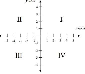
The Cartesian coordinate system is a coordinate system that is employed to uniquely describe the location of points on a plane or a space (Aufmann, Barker, & Nation, 2010; Szecsei, 2006). In the plane, two perpendicular axes: the horizontal axis (x-axis) and the vertical axis (y-axis) form this system and they intersect at the zero point (Aufmann et al., 2010). Those two axes of this system partition the plane into four regions called quadrants numbered counterclockwise (see figure 1). Here, the positive numbers exist in the right of the origin on the x-axis and above the origin on the y-axis (see figure 1).
Figure 14: The Cartesian coordinate system with four quadrants
The Cartesian system is not a simple concept because many crucial components (e g. coordinate axes, origin, ordered pair, etc) need to be understood. Considering this issue, this study merely focuses its domain on positive quadrant (the first quadrant).
Realistic Mathematics Education (RME)
To make clear how the designed-learning sequences help children to specify the location of points using the Cartesian system, realistic mathematics education (PMRI) is used as the grounded theory. Instead of giving ready-made concepts, students should be
facilitated to reinvent those concepts under teacher’s guidance and the instructional
of an ordered pairs to specify the location of points on the plane. Afterwards, we help them to describe the location of a certain point by using the ordered pairs.
1. Understanding the use of an ordered pairs
To describe the location of the points, an ordered pair (x ,y) is employed. The value x
represents the horizontal distance between the point and the y-axis, while the value
y represents the vertical distance between the point and the x-axis (Szecsei, 2006). In this study, children at first are asked to specify the location of an object on a map by using the information related to the horizontal and the vertical distance. This is a preliminary activity before children are introduced to the use of an ordered pair.
To understand how the ordered pairs work, children are challenged to an issue about which distance (horizontal or the vertical distance) that should be considered as the first and the second coordinate of the ordered pair. Under the guidance of the teacher, they are invited to make an agreement that the horizontal distance is notated as the first coordinate as the conventional agreement employed.
2. Locating points on the positive quadrant using the ordered pairs
A common misconception experienced by children is describing points in the Cartesian plane using the ordered pairs (Sarama et al., 2003). Children tend to reverse the value x and y of the ordered pairs (x, y) (Sarama et al., 2003). For instance, when being asked to locate a point along the x-axis, they do not describe the point at (x, 0), but at (0, x). It is also happened for describing a point along the y-axis. To anticipate this misconception, children are challenged to an issue about which distance, the horizontal (x-value) or the vertical (y-value) distance that should be considered as the first coordinate. This activity lead to an agreement about notating the horizontal distance (x-value) as the first coordinate.
The issue related to how to locate a point that is not located in the intersection of the gridlines becomes one of the important aspects that children need to understand
Palupi, . One of which is involving fractions or decimals a half as one of its
coordinate. According to Palupi (2013), children still have difficulty in locating a
point that has the value half for the x-value and/ or the y-value. Consequently, in this study, children are challenged to locate an object in the sea map that involves
half as one of its coordinate by using the ordered pairs.
METHOD
Research Approach
This study is mainly aimed at supporting students’ understanding of the positive
research on how these materials support students’ understanding. Consequently, the
methodology of this research falls under design research approach.
A macro cycle of design research consists of three phases: preparation, teaching experiment, and retrospective analysis (Gravemeijer & Cobb, 2006). During the preparation, as the main point, we formulate the hypothetical learning trajectory (HLT). Afterwards, we test and improve the HLT within two cycles (pilot experiment and teaching experiment) because of the limited time for the analysis. In the retrospective analysis, we confront the actual learning in the class with the learning conjectures described in the HLT. Based on the analysis, we draw conclusion and answer the research questions.
Data Collection and Data Analysis
As a part of a big research, the data presented in this article is taken from the pilot teaching experiment. Before conducting the pilot experiment, we conduct a pre-test to
know students’ current knowledge. After accomplishing the pilot experiment, we conduct
a post-test to know the change of students’ understanding. )n the pilot experiment, the initial HLT is implemented to a small group of four students and the researcher acts as the teacher. We collect video registration of classroom activities, make field notes and
collect students’ written work during the pilot experiment.
The result of the pre-test is analyzed qualitatively by considering students’ reasoning in solving the problem. Not only being analyzed qualitatively, the result of post-test is also compared with the result of pre-test. The data gathered from the pilot experiment, either
the interesting video fragment and/or students’ written work are analyzed by comparing it with conjectured learning the initial HLT. In the end, from the whole analysis, we can draw a conclusion for answering the research question and improve the initial HLT before implementing it in the real teaching experiment.
Participants
This study is conducted in SD Pusri, Palembang, Indonesia and it involves four students of the 5th grade who are divided into two groups. The first group consists of two female students, while the second group has two male students.
RESULT AND DISCUSSION
Pre-test
The result of the pre-test shows that some the students still have difficulty in describing the location of an object on a plane using two parameters: distance and the cardinal direction. They only use one parameter that leads to imprecise location (see figure 2).
However, two other students could locate it using the two given parameters (see figure 3). In addition, one of them could locate it using a pair of coordinate, yet with additional information related to the cardinal direction (see figure 4).
Figure 16: Two example of students' written work on locating an object using two parameters
When being worked with the formal task, two of the students did not use a pair of coordinate to locate a point on the Cartesian plane. They still used the information related to the cardinal direction. However, the other two students have begun to locate it using a coordinate pair, but with different direction either the horizontal or the vertical first (see figure 4).
Figure 17: Two example of students' work on locating a point by using a pair of coordinate
Teaching Experiment
To answer the research question, three out of six instructional activities that has been designed and implemented will be discussed in detail. The three activities are mainly about understanding how the ordered pairs work and specify the location of an object on a map or a point by using the Cartesian coordinate system, yet focused on the positive quadrant. However, before students deal with this activity, they have reinvented a system that looks like the positive quadrant in the other two previous activities. Therefore, the system is directly embedded in the following activities.
1. Locating Objects in the Street Map of the City Blocks
The activity was started by asking the students to locate two objects from a certain origin on the map that looks like the positive quadrant. To locate it, all of them used the information related to the horizontal and the vertical distance and combined it with the cardinal direction as we predicted in the HLT (see figure 5). It means that none of them used a pair of numerical coordinate.
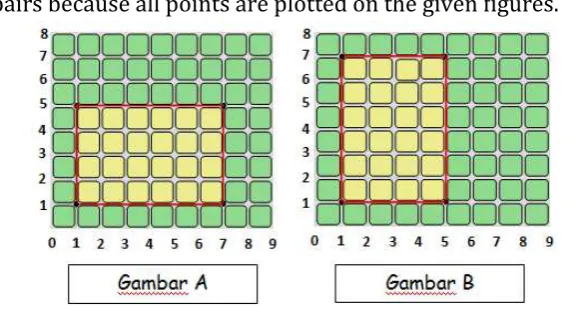
formed by those points (see figure 6). Here, they need to argue which distance (the horizontal and the vertical distance) that should be notated as the first coordinate of the ordered pairs because all points are plotted on the given figures.
Figure 19: Optional figures that can be formed by the given four points
As mentioned in the HLT, some of the students at first argued that the second figure is the answer because all of the given coordinate were plotted. However, when being asked to consider the first coordinate as the horizontal distance, they ended up with the figure A. Realizing this fact all of students agreed that the points could be plotted in two different ways as shown in the following fragment.
Fragment 1: Two different ways of plotting the ordered pairs
1 Teacher : Which figure does show the danger zone?
2 Darren : Both of the figures. For figure A, we consider the horizontal coordinate as the first coordinate. For figure B, we consider the vertical distance first
Based on fragment 1, it was claimed that the way they plot the points depends on which distance (the horizontal or the vertical distance) they consider the first coordinate (line 1 -2). The lesson was continued with the discussion about the need of agreement about the use of the ordered pairs. Here, all of the students agreed that the horizontal distance is considered as the first coordinate.
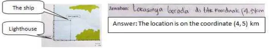
2. Locating Ships on the Sea Map
Figure 20: The first group's written work on locating the sunken ship
In the other hand, the second group specified it using the ordered pair (y, x) as we conjectured in the HLT. However, after being clarified about the agreement about the ordered pairs, they corrected their answer into (x, y) (see figure 8).
Figure 21: The second group's written work on locating the sunken ship
The task was continued with describing the location of the rescue ships that placed along the x-axis or y-axis. They also worked on locating rescue ship that one of its
coordinate has value half . )n the following fragment, the first group seemed had no significant difficulty in determining the coordinate of those objects.
Fragment 2: The first group locates points along the x-axis or y-axis
1 Siti : The team SAR C is in the coordinate (0,7) 2 Teacher : What do you mean by 0 in here?
3 Salsa : 0 is the horizontal (distance) and 7 is the vertical (distance) 4 Teacher : How about the team SAR B?
5 Salsa : Nine a half point four (9 ½ , 4) 6 Teacher : How about the team SAR team A? 7 Siti : Four a half point zero (4 ½ ,0) 8 Teacher : How did you get 0 here?
9 Salsa : Because of no vertical (distance)
Based on fragment 2 above, the students tried to find both the horizontal and the vertical distance to help them specify the coordinate of each object (line 3). They were even able to understand that if a point located along the x-axis or y-axis, one of its distance (either horizontal or vertical) is equal to zero (line 2, 3, 8, and 9). In addition, it was clear that they also had no difficulty to write the ordered pair of an object on the map that has half as one of its coordinate line 5, .
It was different for the second group. As shown in the following fragment, they had little difficulty in expressing the ordered pair of an object placed along the axis and it
Fragment 3: The second group locates a point along the x-axis
1 Teacher : How about (the coordinate) of the team SAR A? 2 Basith : 4,5
3 Teacher : )t is for the horizontal distance , isn’t it? 4 Basith : Yes
5 Teacher : How about the vertical (distance)? 6 Darren : Zero
7 Teacher : And then, how did you write down (the coordinate)? 8 Darren : (0, 45)
9 Teacher : (The agreement) is the horizontal or the vertical first? 10 Basith : The horizontal, that is (45, 0)
11 Teacher : 45 or 4,5?
12 Darren : 4,5 so that (4,5 , 0)
According to fragment 3, the students only considered one parameter (the horizontal distance) to locate the object (line 1-4). However, after being asked about the vertical distance, they could understand that it is equal to zero because of being located along the x-axis (5-6). Under the guidance of the teacher, in addition, they could express the coordinate using the ordered pair (line 12)
Figure 22: Two groups' written work on locating the rescue team using the ordered pair Those results show that all of students were able to determine the coordinate of any objects on the map that looks like the positive quadrant of the Cartesian system.
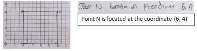
3. Locating Points on the Positive Quadrant of the Cartesian Coordinate System
In the last activity, students played a game called Guess the Last Point in which they need to determine the coordinate of the forth point if given three points that can be formed into a special quadrilateral. For the first task, all of the groups could determine the coordinate of the last point S after they plotting the given three points (point P, Q, and R) correctly (see figure 10).
Similarly, all of them had no difficulty in determining the coordinate of the last point
N that has half as one of its coordinate see figure .
Figure 24: Students' written work on determining the coordinate of point N
These findings reveal that students were able to determine the coordinate of any points on the positive quadrant by using the ordered pairs (x, y).
Post-test
In general, the result of the post-test reveals that all of students have been able to specify the location of an object (a point) on a map either using the ordered pair or employing two parameters: the distance and the cardinal direction (see figure 12).
Figure 25: Student's written work on specifying the location of a object on the map that looks like the positive quadrant of the Cartesian coordinate system
In addition, when working with the formal task, all of them were able to determine the coordinate of any points on the positive quadrant of the Cartesian system correctly by using the ordered pairs (see figure 13).
CONCLUSIONS
The research question of this study is how can we support students in specifying the location of points on the positive quadrant of the Cartesian coordinate system? To answer
this question, we will focus on how the students know how an ordered pairs (x, y) works on locating a point by considering terms about the horizontal and the vertical distance. Afterwards, we will describe on how the students specify the coordinate of a object on a map or a point on the positive quadrant of the Cartesian coordinate system by using the ordered pairs (x, y).
In conclusions, we may say that the students at first specified the coordinate of an object from an origin on a map by using the distance and the cardinal direction (mainly east and north). This finding was apparently a good starting points before understanding on how an ordered pairs (x, y) work in specifying a certain location. After having discussion about which distance (horizontal or the vertical distance) that should be notated as the value x
or y, they made an agreement that the value z represent the horizontal distance.
Their understanding about the horizontal and the vertical distance leads them to specify the coordinate of any object (any point) on the map that looks like the positive quadrant by using the ordered pairs. It was also similar when being asked to locate any points on the positive quadrant of the Cartesian coordinate system. For an object or a point located along the x-axis or the y-axis, they were able to see that the horizontal or the vertical distance should be zero such as (5, 0), (0, 7), etc. In addition, for an object or a point that
has half as one of its coordinate, they were also able to express it in fraction or decimal
such as (9 ½, 4), (4.5, 0), etc.
ACKNOWLEDMENTS
A special gratitude we dedicate to Indonesian Directorate General of Higher Education (DIKTI), Indonesia and NUFFIC NESO, the Netherlands for funding International Master Program on Mathematics Education (IMPoME).
REFERENCES
Aufmann, R., Barker, V. C., & Nation, R. (2010). College Algebra and Trigonometry. Boston: Cengage Learning
Blades, M., and Spencer, C. . Young Children’s Ability To Use Coordinate
References. The journal of Genetic Psychology, 150(1), 5-8
Clement, D. H., & Sarama, J. (2009). Spatial Thinking. In D. H. Clement, & J. Sarama,
Learning and Teaching Early Math: The Learning Trajectories Approach (pp. 107-122). New York & London: Routledge Taylor &Francis Group.
Palupi, E. L. W. (2013). Design Research on Mathematics Education: Understanding Coordinate System. Master Thesis. Sriwijaya University
Sarama, J., Clements, D. H., Swaminathan, S., McMillen, S., & Gomez, R. M. G. (2003). Development of Mathematical Concepts of Two-Dimensional Space in Grid Environment: An Exploratory Study. Cognition and Instruction, 21 (3), 285-324
Shantz, C. U. & Smock, C. D. (1966). Development of distance conservation and the spatial coordinate system. Child Development, 37, 943-948
Somerville, S. C., & Bryant, P. E. 5 . Young Children’s Use of Spatial Coordinates. Child Development, 56, 604-613
Szecsei, D. (2006). Trigonometry: Homework Helpers Series. Franklin Lakes: Career Press
Treffers, A. (1987). Three dimensions. A model of goal and theory description in mathematics instruction - The Wiskobas project. Dordrecht, the Netherlands: Reidel Publishing Company.