Open Geospatial Consortium
Approval Date: 07 September 2012
Publication Date: 02 October 2012
External identifier of this OGC® document: http://www.opengis.net/doc/IS/netcdf-enhanced/1.0
Internal reference number of this OGC® document: OGC 11-038r2
Version: 1.0
Category: OGC® Standard
Editor: Ben Domenico
OGC Network Common Data Form (NetCDF) NetCDF Enhanced Data Model Extension Standard
Copyright notice
Copyright © 2012 Open Geospatial Consortium.
To obtain additional rights of use, visit http://www.opengeospatial.org/legal/.
Warning
This document is an OGC Member approved international standard. This document is available on a royalty free, non-discriminatory basis. Recipients of this document are invited to submit, with their comments, notification of any relevant patent rights of which they are aware and to provide supporting documentation.
Document type: OGC® Standard Document subtype:
License Agreement
Permission is hereby granted by the Open Geospatial Consortium, ("Licensor"), free of charge and subject to the terms set forth below, to any person obtaining a copy of this Intellectual Property and any associated documentation, to deal in the Intellectual Property without restriction (except as set forth below), including without limitation the rights to implement, use, copy, modify, merge, publish, distribute, and/or sublicense copies of the Intellectual Property, and to permit persons to whom the Intellectual Property is furnished to do so, provided that all copyright notices on the intellectual property are retained intact and that each person to whom the Intellectual Property is furnished agrees to the terms of this Agreement.
If you modify the Intellectual Property, all copies of the modified Intellectual Property must include, in addition to the above copyright notice, a notice that the Intellectual Property includes modifications that have not been approved or adopted by LICENSOR.
THIS LICENSE IS A COPYRIGHT LICENSE ONLY, AND DOES NOT CONVEY ANY RIGHTS UNDER ANY PATENTS THAT MAY BE IN FORCE ANYWHERE IN THE WORLD.
THE INTELLECTUAL PROPERTY IS PROVIDED "AS IS", WITHOUT WARRANTY OF ANY KIND, EXPRESS OR IMPLIED, INCLUDING BUT NOT LIMITED TO THE WARRANTIES OF MERCHANTABILITY, FITNESS FOR A PARTICULAR PURPOSE, AND NONINFRINGEMENT OF THIRD PARTY RIGHTS. THE COPYRIGHT HOLDER OR HOLDERS INCLUDED IN THIS NOTICE DO NOT WARRANT THAT THE FUNCTIONS CONTAINED IN THE INTELLECTUAL PROPERTY WILL MEET YOUR REQUIREMENTS OR THAT THE OPERATION OF THE INTELLECTUAL PROPERTY WILL BE
UNINTERRUPTED OR ERROR FREE. ANY USE OF THE INTELLECTUAL PROPERTY SHALL BE MADE ENTIRELY AT THE USER’S OWN RISK. IN NO EVENT SHALL THE COPYRIGHT HOLDER OR ANY CONTRIBUTOR OF
INTELLECTUAL PROPERTY RIGHTS TO THE INTELLECTUAL PROPERTY BE LIABLE FOR ANY CLAIM, OR ANY DIRECT, SPECIAL, INDIRECT OR CONSEQUENTIAL DAMAGES, OR ANY DAMAGES WHATSOEVER RESULTING FROM ANY ALLEGED INFRINGEMENT OR ANY LOSS OF USE, DATA OR PROFITS, WHETHER IN AN ACTION OF CONTRACT, NEGLIGENCE OR UNDER ANY OTHER LEGAL THEORY, ARISING OUT OF OR IN CONNECTION WITH THE IMPLEMENTATION, USE, COMMERCIALIZATION OR PERFORMANCE OF THIS INTELLECTUAL PROPERTY.
This license is effective until terminated. You may terminate it at any time by destroying the Intellectual Property together with all copies in any form. The license will also terminate if you fail to comply with any term or condition of this Agreement. Except as provided in the following sentence, no such termination of this license shall require the termination of any third party end-user sublicense to the Intellectual Property which is in force as of the date of notice of such termination. In addition, should the Intellectual Property, or the operation of the Intellectual Property, infringe, or in LICENSOR’s sole opinion be likely to infringe, any patent, copyright, trademark or other right of a third party, you agree that LICENSOR, in its sole discretion, may terminate this license without any compensation or liability to you, your licensees or any other party. You agree upon termination of any kind to destroy or cause to be destroyed the Intellectual Property together with all copies in any form, whether held by you or by any third party.
Table of Contents
4. Terms and Definitions ... 4
5. Conventions ... 7
6. Clauses not Containing Normative Material ... 8
7. Clauses containing normative material ... 8
7.1 Requirement Class netcdf-enhanced ... 9
7.1.1 NetCDF classic data model ... 9
7.1.2 Data types... 10
7.1.3 Top-level, unnamed group ... 10
7.1.4 Groups ... 10
7.1.5 Variables ... 10
7.1.6 Dimensions ... 10
8. Media Types for any data encoding(s) ... 11
9. References ... 11
Annex A: Conformance Class Abstract Test Suite (Normative) ... 11
A.1 Conformance class: netcdf-enhanced ... 12
A.1.1 Conformance Test 1: http://www.opengis.net/spec/netcdf-enhanced/1.0/conf/netcdf-enhanced/data-model-elements ... 12
A.1.2 Conformance Test 2: http://www.opengis.net/spec/netcdf-enhanced/1.0/conf/netcdf-enhanced/classic-data-model ... 12
A.1.3 Conformance Test 3: http://www.opengis.net/spec/netcdf-enhanced/1.0/conf/netcdf-enhanced/data-types ... 12
A.1.4 Conformance Test 4: http://www.opengis.net/spec/netcdf-enhanced/1.0/conf/netcdf-enhanced/primitive-data-types ... 12
A.1.5 Conformance Test 5: http://www.opengis.net/spec/netcdf-enhanced/1.0/conf/netcdf-enhanced/user-defined-data-types ... 12
A.1.6 Conformance Test 6: http://www.opengis.net/spec/netcdf-enhanced/1.0/conf/netcdf-enhanced/top-level-group ... 13
A.1.7 Conformance Test 7: http://www.opengis.net/spec/netcdf-enhanced/1.0/conf/netcdf-enhanced/shared-dimensions ... 13
Annex B: Revision history ... 14
1 Copyright © 2012 Open Geospatial Consortium.
Abstract
When there are multiple valid representations for the same information, humans may understand and ignore gratuitous differences. For example, a human reader recognizes that the strings "Temperature" and "temperature" very likely refer to the same quantity. It is impractical, however, to develop software that has to deal with multiple representations of the same information. A convention that declares one representation is favored above others (even though all representations may be technically equivalent) makes
interoperable software practical, because it only needs to deal with one way to represent the information.
Standard data models and data storage formats allow for the creation of data conventions that foster this interoperability. A data model is an abstract conceptual layer that
describes how different types of data should be represented, independent of any particular software application or hardware configuration. A data format is a description of how data organized according to a particular data model should be stored on physical storage media by software applications. Data conventions can then build upon the infrastructure provided by the data model and data format to imbue specific data collections with meaning that is understood by a wide variety of software applications.
This standard deals with enhancements to the netCDF (Network Common Data Form) data model for array-oriented scientific data..
Two important data models for netCDF are:
the “classic” netCDF model, used for netCDF-3 and earlier versions an enhanced data model, used in netCDF-4 and later versions.
The netCDF classic data model is defined in OGC 10-091r3, “NetCDF Core.”
This document specifies a netCDF extension standard for the enhanced data model. The OGC netCDF encoding supports electronic encoding of geospatial data, specifically digital geospatial information representing space- and time-varying phenomena.
NetCDF (network Common Data Form) is a data model for array-oriented scientific data. The netCDF classic data model is specified in the netCDF core specification. This
2 Copyright © 2012 Open Geospatial Consortium.
i.
Keywords
ogcdoc, netcdf, space-time, netcdf-enhanced
ii.
Preface
Attention is drawn to the possibility that some of the elements of this document may be the subject of patent rights. The Open Geospatial Consortium shall not be held
responsible for identifying any or all such patent rights.
Recipients of this draft document are requested to submit, with their comments,
notification of any relevant patent claims or other intellectual property rights of which they may be aware that might be infringed by any implementation of the standard set forth in this document, and to provide supporting documentation.
iii.
Submitting organizations
The following organizations submitted this Document to the Open Geospatial Consortium Inc.
University Corporation for Atmospheric Research (UCAR)
iv.
Submitters
All questions regarding this submission should be directed to the editor or the submitters:
Name Company
3 Copyright © 2012 Open Geospatial Consortium.
1.
Scope
NetCDF (Network Common Data Form) is a data model for array-oriented scientific data. There is a freely distributed collection of access libraries implementing support for that data model in a machine-independent format. Together, the interfaces, libraries, and format support the creation, access, and sharing of scientific data.
Background information regarding the overall landscape of netCDF standards is
presented in the CF-netCDF Primer, OGC 10-091r3, “CF-netCDF: Core and Extensions.” This standard is an extension to the core specification for the netCDF Classic data model in OGC 10-090r3, “NetCDF Core.”
This document specifies the netCDF Enhanced Data Model.
2.
Conformance
This Standard defines the netCDF enhanced data model.
Standardization targets are netCDF implementations (currently: encodings). This document establishes a single requirements class, netcdf-enhanced, of http://www.opengis.net/spec/netcdf/1.0/req/netcdf-enhanced
with a single pertaining conformance class, netcdf enhanced, with URI http://www.opengis.net/spec/netcdf/1.0/conf/netcdf-enhanced.
All requirements-classes and conformance-classes described in this document are owned by the standard identified as http://www.opengis.net/spec/netcdf-enhanced/1.0 .
Annex A (normative) specifies conformance tests which shall be exercised by any encoded dataset claiming to implement an OGC netCDF encoding.
Conformance with this standard shall be checked using all the relevant tests specified in Annex A (normative) of this document. The framework, concepts, and methodology for testing, and the criteria to be achieved to claim conformance are specified in the OGC Compliance Testing Policies and Procedures and the OGC Compliance Testing web site1.
4 Copyright © 2012 Open Geospatial Consortium.
3.
References
The following normative documents contain provisions that, through reference in this text, constitute provisions of this document. For dated references, subsequent
amendments to, or revisions of, any of these publications do not apply. For undated references, the latest edition of the normative document referred to applies.
The netCDF classic data model is defined in OGC 10-091r3, “NetCDF Core.” The standard defined in this document is an extension to that core specification.
Consequently all provisions stated in the NetCDF Core apply to the NetCDF Enhanced Data Model defined herein.
In addition to the normative reference noted above, portions of this document are taken from the Unidata NetCDF User’s Guide
http://www.unidata.ucar.edu/software/netcdf/docs/netcdf.html
and from the NASA Earth Science Data Systems (ESDS) Standards Process Group (SPG) document ESDS-RFC-022, NetCDF-4/HDF5 File Format,
http://earthdata.nasa.gov/our-community/esdswg/standards-process-spg/rfc/esds-rfc-022
4.
Terms and Definitions
This document uses the terms defined in Sub-clause 5.3 of [OGC 06-121r8], which is based on the ISO/IEC Directives, Part 2, Rules for the structure and drafting of
International Standards. In particular, the word “shall” (not “must”) is the verb form used
to indicate a requirement to be strictly followed to conform to this standard.
For the purposes of this document, the following additional terms and definitions apply.
These definitions are all of definition type “property.” The base URI to be used with the
URI tokens is:
http://www.opengis.net/def/property/netcdf/1.0/{URI_token}
Note:
The netCDF data types are based on the IETF XDR standard
5 Copyright © 2012 Open Geospatial Consortium.
4.1
byte*
A byte is an eight-bit integer. The byte type differs from the char type in that it is intended for eight-bit data, and the zero byte has no special significance, as it may for character data. URI token: byte.
4.2
char*
A char is an 8-bit byte that contains uninterpreted character data. Typically a char contains a 7-bit ASCII character, but the character encoding is application-specific. URI token: char.
4.3
compound type
Compound types group together named fields (also called "members"), that may be of different types, into a structure that may be accessed as a unit. It has a fixed total size. It consists of zero or more named members that do not overlap with other members.
Each member has a name distinct from other members. Each member has its own datatype.
Each member is referenced by an index number between zero and N-1, where N is the number of members in the compound datatype.
Each member has a fixed byte offset, which is the first byte (smallest byte address) of that member in the compound datatype.
In addition to other other user-defined data types or atomic datatypes, a member can be a small fixed-size array of any type with up to four fixed-size
“dimensions” (not associated with named netCDF dimensions).
URI token: compoundType.
4.4
double*
A double is an IEEE double-precision floating point (64 bits.). The double type can hold values between about -1.7+308 and 1.7+308, with external representation as 64-bit IEEE standard normalized double-precision, floating-point numbers. URI token: double.
4.5
enumerated (enum) type
6 Copyright © 2012 Open Geospatial Consortium.
4.6
float*
A float is an IEEE single-precision floating point (32 bits). The float type can hold values between about -3.4+38 and 3.4+38, with external representation as 32-bit IEEE normalized single-precision floating-point numbers. URI token: float.
4.7
group
A group provides a nested scope for names. URI token: group.
4.8
int*
An int is a 32-bit signed integer. An int can hold values between -2147483648 and 2147483647. URI token: int
4.9
int64
An int64 is an eightbyte signed integer. An int64 can hold values between -9223372036854775808 and 9223372036854775807. URI token: int64.
4.10
long*
The long type is deprecated. It is synonymous with int. URI token: long.
4.11
opaque type
Opaque is a collection of objects of a known size. Each object is the same size. Nothing is known to netCDF about the contents of these blobs of data, except their size in bytes, and the name of the type. URI token: opaqueType.
4.12
real*
The real type is synonymous with float. URI token: real.
4.13
short*
A short is a 16-bit signed integer. A short holds values between -32768 and 32767. URI token: short.
4.14
string
7 Copyright © 2012 Open Geospatial Consortium.
4.15
unsigned int
An unsigned int is a 32-bit unsigned integer. An unsigned int holds values between 0 and 4294967296. URI token: unsignedInt
4.16
unsigned int64
An unsigned int64 is an unsigned 8-byte integer type. An unsigned int64 can hold values between 0 and 18446744073709551616. URI token: unsignedInte64.
4.17
unsigned short
An unsigned short is a 16-bit unsigned integer. An unsigned short holds values between 0 and 65536. URI token: unsignedShort.
4.18
user defined type
User defined types are: compound, enumerated, variable-length, and opaque. URI token: userDefinedType.
4.19
variable length type
The variable length type represents a one-dimensional array of variable length. URI token: variableLengthType.
*Note that, for purposes of completeness and readability, the definitions of all the
primitive data types are included here. However, char, byte, short, double, float, and real are actually part of the netCDF classic data model and hence are part of the core netCDF specification.
5.
Conventions
Some abbreviated terms frequently used in conjunction with enhanced netCDF: API Application Program Interface
BNF Backus-Naur Form
CF Climate and Forecast Conventions
ESDSWG NASA Earth Standards Data Systems Working Groups
8 Copyright © 2012 Open Geospatial Consortium. GIS Geographic Information System
HDF5 Hierarchical Data Format version 5
NcML NetCDF Markup Language
NcML-GML NetCDF Markup Language – Geography Markup Language NetCDF Network Common Data Form
NetCDF-4 NetCDF Release 4
ISO International Organization for Standardization OGC Open Geospatial Consortium
SPG NASA Standards Process Group UML Unified Modeling Language XML eXtended Markup Language WFS Web Feature Service
WCS Web Coverage Service
6.
Clauses not Containing Normative Material
There are no clauses with non normative material.
7.
Clauses containing normative material
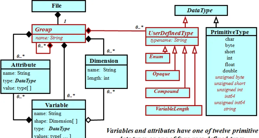
The netCDF enhanced data model adds Groups and User-Defined Types to the classic netCDF data model, but backward compatibility is preserved. The netCDF enhanced data model is also known as the netCDF-4 data model.
9 Copyright © 2012 Open Geospatial Consortium. Figure 1: UML Diagram for netCDF Enhanced Data Model
7.1 Requirement Class netcdf-enhanced
There is only one requirements class for the Enhanced NetCDF Data Model. It is netcdf-enhanced.
http://www.opengis.net/spec/netcdf-enhanced/1.0/req/req-class/netcdf-enhanced
Req 1 http://www.opengis.net/spec/netcdf-enhanced/1.0/req/netcdf-enhanced/data-model-elements
NetCDF enhanced datasets shall represent information using groups, dimensions, variables, and attributes using the data types as shown in the UML diagram in Figure 1.
7.1.1 NetCDF classic data model
Req 2 http://www.opengis.net/spec/netcdf-enhanced/1.0/req/netcdf-enhanced/classic-data-model
10 Copyright © 2012 Open Geospatial Consortium. follow. Related conformance test cases are defined in Annex A of OGC 10-090r3,
“NetCDF Core.”
7.1.2 Data types
Req 3 http://www.opengis.net/spec/netcdf-enhanced/1.0/req/netcdf-enhanced/data-types
Variables and attributes shall have one of 12 primitive data types or one of four user-defined data types
Req 4 http://www.opengis.net/spec/netcdf-enhanced/1.0/req/netcdf-enhanced/primitive-data-types
A primitive data type shall be one of char, byte, short, int, int64, float, double, unsigned byte, unsigned short, unsigned int, unsigned int64, string.
Note: This extends the corresponding netCDF core requirement which only allows the char, byte, short, int, float, and double primitive data types.
Req 5 http://www.opengis.net/spec/netcdf-enhanced/1.0/req/netcdf-enhanced/user-defined-data-types
A user-defined data type shall be one of enumerated, opaque, compound, variableLength.
7.1.3 Top-level, unnamed group
Req 6 http://www.opengis.net/spec/netcdf-enhanced/1.0/req/netcdf-enhanced/top-level-group
A netCDF dataset shall have one top level, unnamed group. In this context an unnamed group is equivalent to a group whose name is the null string.
Note: The top-level unnamed group provides backward compatibility with netCDF classic files, which have no groups. Thus, a netCDF classic file can be thought of as a netCDF enhanced model file with only the top-level unnamed group.
7.1.4 Groups
Each group may contain zero or more named subgroups, user-defined types, variables, dimensions, and attributes.
7.1.5 Variables
Variables may have attributes.
7.1.6 Dimensions
11 Copyright © 2012 Open Geospatial Consortium.
7.1.6.1 Shared dimensions
Variables may share dimensions.
Req 7 http://www.opengis.net/spec/netcdf-enhanced/1.0/req/netcdf-enhanced/shared-dimensions
Shared dimensions shall indicate a common grid.
8.
Media Types for any data encoding(s)
The MIME type application/x-netcdf is unregistered, since it doesn't appear in the list at http://www.iana.org/assignments/media-types/index.html
It is, however, in common use; you can find it listed among the "MIME Types by Content Type" at
http://webdesign.about.com/od/multimedia/a/mime-types-by-content-type.htm
and in the list of various MIME types at
http://www.htaccess-guide.com/adding-mime-types/
and many other places.
9.
References
OGC 10-090r3, netCDF Classic Core Interface Standard OGC 10-091r3, CF-netCDF Core and Extensions Primer IEEE 754-2008, Standard for Floating-Point Arithmetic
ISO/IEC 10646, Universal multiple-octet coded character set (UCS)
12 Copyright © 2012 Open Geospatial Consortium.
A.1 Conformance class: netcdf-enhanced
There is only one conformance class for the Enhanced NetCDF Data Model. It is netcdf-enhanced.
http://www.opengis.net/spec/netcdf-enhanced/1.0/conf/conf-class/netcdf-enhanced A.1.1 Conformance Test 1:
http://www.opengis.net/spec/netcdf-enhanced/1.0/conf/netcdf-enhanced/data-model-elements
Open the dataset and verify that it represents information using groups, dimensions, variables, and attributes using the data types as shown in the UML diagram in Figure 1. A.1.2 Conformance Test 2:
http://www.opengis.net/spec/netcdf-enhanced/1.0/conf/netcdf-enhanced/classic-data-model
[Dependencies: netCDF classic abstract model as specified in the document OGC 10-090,
“NetCDF Core.” Annex A of OGC 10-090, “NetCDF Core.” ]
Open the dataset and verify that data conform to the netCDF classic abstract model as specified in the document OGC 10-090, “NetCDF Core” with the extensions specified in the following conformance tests. Related conformance test cases are defined in Annex A of OGC 10-090, “NetCDF Core.”
A.1.3 Conformance Test 3: http://www.opengis.net/spec/netcdf-enhanced/1.0/conf/netcdf-enhanced/data-types
Open the dataset and verify that variables and attributes have one of 12 primitive data types or one of four user-defined data types
A.1.4 Conformance Test 4: http://www.opengis.net/spec/netcdf-enhanced/1.0/conf/netcdf-enhanced/primitive-data-types
Open the dataset and verify that primitive data type are one of char, byte, short, int, int64, float, double, unsigned byte, unsigned short, unsigned int, unsigned int64, string.
Note: This extends the corresponding netCDF core conformance test which only allows the char, byte, short, int, float, and double primitive data types.
A.1.5 Conformance Test 5: http://www.opengis.net/spec/netcdf-enhanced/1.0/conf/netcdf-enhanced/user-defined-data-types
13 Copyright © 2012 Open Geospatial Consortium. A.1.6 Conformance Test 6:
http://www.opengis.net/spec/netcdf-enhanced/1.0/conf/netcdf-enhanced/top-level-group
Open the dataset and determine that it has one top level, unnamed group. In this context an unnamed group is equivalent to a group whose name is the null string.
A.1.7 Conformance Test 7: http://www.opengis.net/spec/netcdf-enhanced/1.0/conf/netcdf-enhanced/shared-dimensions
14 Copyright © 2012 Open Geospatial Consortium.
Annex B: Revision history
Date Release Author Paragraph modified Description