VERTICAL ACCURACY COMPARISON OF DIGITAL ELEVATION MODEL FROM
LIDAR AND MULTITEMPORAL SATELLITE IMAGERY
Jali Octariadya*, Agus Hikmata, Elyta Widyaningruma, Ratna Mayasaria, Marda Khoiria Fajaria
a Geospatial Information Agency of Indonesia (BIG) - (jali.octariady, agus.hikmat, elyta.widyaningrum, ratna.mayasari, marda.khoiria)@big.go.id
Commission II, WG II/4
KEY WORDS: Vertical Accuracy, LiDAR DEM, Multitemporal Stereo Satellite Imagery, DEM.
ABSTRACT:
Digital elevation model serves to illustrate the appearance of the earth's surface. DEM can be produced from a wide variety of data sources including from radar data, LiDAR data, and stereo satellite imagery. Making the LiDAR DEM conducted using point cloud data from LiDAR sensor. Making a DEM from stereo satellite imagery can be done using same temporal or multitemporal stereo satellite imagery. How much the accuracy of DEM generated from multitemporal stereo stellite imagery and LiDAR data is not known with certainty. The study was conducted using LiDAR DEM data and multitemporal stereo satellite imagery DEM. Multitemporal stereo satellite imagery generated semi-automatically by using 3 scene stereo satellite imagery with acquisition 2013-2014. The high value given each of DEM serve as the basis for calculating high accuracy DEM respectively. The results showed the high value differences in the fraction of the meter between LiDAR DEM and multitemporal stereo satellite imagery DEM.
* Corresponding author
1. INTRODUCTION
Digital elevation model have many benefits. Digital elevation model serves to illustrate the appearance of the earth's surface (Ebner, et al., 1988). Some activities require a digital elevation model data namely orthorectification image, erosion control, flood simulation, creation of contour lines, and many others (Jacobsen, 2003).
Digital elevation models can be produced from a wide variety of manner and a wide variety of data sources such as digitized using topographical map (Li, et al., 2010; Kang, et al., 2008; Narender, et al., 2006), field measurements using a total station or Global Positioning System (GPS) (Li, et al., 2010; Jacobsen, 2003), using overlap of satellite imagery or aerial photograph (Li, et al., 2010; Srivastava, et al., 2007; Nadeem, et al., 2006; Jacobsen, 2003), using SAR imagery and using LiDAR point cloud (Li, et al., 2010; Jacobsen, 2003). Each of these methods will produce digital elevation models data with different accuracy (Li, et al., 2010). Up to this time, the DEM data that has a high accuracy DEM is LiDAR DEM. Vertical Accuracy LiDAR DEM can reach 30 cm with many kind of spatial resolution. (Liu, 2008).
Currently in Indonesia, the manufacture of large-scale maps of 1: 5000 using satellite imageries data is not contain with contours data. The map only present 2D information. High information can be generated from stereo satellite imageries. However, because of doubts in the accuracy of the DEM generated from stereo satellite imageries, the DEM is not formed and high information is not displayed on the map. Need to do a comparison of the DEM generated from stereo satellite imageries to other precise DEM to determine the vertical accuracy of the DEM from stereo satellite imageries. This paper discuss about vertical acuracy comparison of digital elevation model from LiDAR and Multitemporal Stereo Satellite Imageries.
2. STUDY AREA
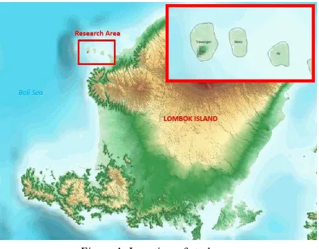
The selected reasearch area of this paper is three island of Indonesia namely Gili Trawangan Island, Gili Meno Island, and Gili Air Island. The three island located near Lombok Island (figure 1). These Island has flat topography surface between 0 - 71m of MSL.
Figure 1. Location of study area
Gili Trawangan Island has the famous island and tourism industries in Indonesia and in the world. The undergoing rapid development in Gili Trawangan Island mainly to facilitate domestic and foreign tourists needs during their visit. This situation resulting many new building and road accesses throughout the island, this situation make a different appearance from multitemporal stereo satellite imageries. It is necessary to
be considered in the process of making a DEM from multitemporal stereo satellite imageries.
3. DATA
There are three main data used in this study namely Ground Control Point, Multitemporal Satellite Imageries, and LiDAR Digital Elevation Model.
3.1 Ground Control Point
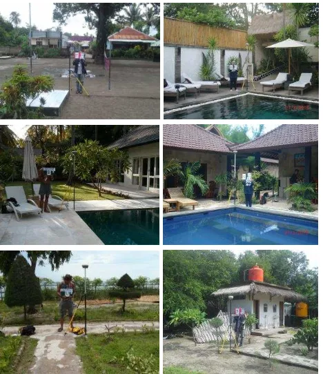
The Ground Control Point (GCP) data are acquired though field works by using GPS Geodetic dual frequency and static measurement method. Each GCP object is located on an object that easily identified in the image and in the field such us corner of street, swimming pole, etc (figure 2).
Figure 2. GCP and ICP field measurement in various object There are 6 GCP used for geometric correction of satellite imageries. All of the GCP can be identified in multitemporal stereo satellite imageries. Beside GCP, there are 12 ICP that used to evaluate the quality of DEM. Same like GCP, ICP are acquired though field works by using GPS geodetic dual frequency and static method. GCP and ICP spread evenly throughout image coverage. This is done in order to GCP and ICP may represent the surface terrain of the area taken by it (figure 3).
Figure 3. Distribution GCP and ICP over the satellite imagery
Horizontal accuracy of GCP and ICP data processing better than 15cm. This is done so that the corrected image having good accuracy. GCP and ICP has an accuracy lower than 15 cm must be processing again or repeatability of measurements with a longer observation time.
3.2 Multitemporal Stereo Satellite Imageries.
There are 3 scene Worldview-2 satellite imageries are used in this research. The accusition time of the satellite imageries are October 2013, June 2014, and May 2014 (figure 4) with incidence angle varying each other. One scene satellite imagery coverage all of island in this research. Each satellite image have overlap 100%.
(a)
(b)
(c)
Figure 4. Satellite image with accusition time October 2013 (a), May 2014 (b), and June 2014 (c)
Satellite imagery have 2 channels namely multispectral with 3 bands and panchromatic with one band. Multispectral Channel has a spatial resolution of 2m, while the panchromatic channel has a spatial resolution of 0.5m. The channels used for making a DEM in this study is panchromatic channel. Panchromatic channel selected because this channel have the best spatial resolution.
3.3 Point Cloud LiDAR.
The airborne LiDAR on the area study surveyed in June 2016. The point density of the LiDAR point cloud is 4 ppm (point per metre square). The vertical accuracy of the LiDAR point cloud compared to the previous GNSS survey is better than 20 cm RMSEz. LiDAR DEM obtained after automatic point cloud classification and manual editing process .
4. METHODOLOGY
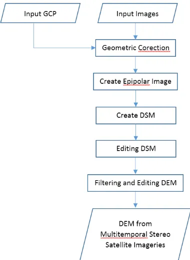
4.1 Multitemporal Stereo Satellite Imageries DEM. DEM formation begins with geometric correction of multitemporal stereo satellite imageries using 6 GCP. After correction done, do epipolar image formation. Epipolar image formed from a combination of three images. There are three epipolar image formed from 3 combinations of satellite imagery, epipolar image from satellite image october 2013 and june 2014, october 2013 and may 2014, and may 2014 and june 2014. After epipolar image formed then carried DSM formation. DSM is formed at a spatial resolution of 1m. Manually editing done on DSM formed, mainly on the object with difference appearance due to difference time accusition. Filtering and manual editing is done to convert the DSM into DEM. Figure 6 presents the flowchart of the processing making a DEM from multitemporal stereo satellite imagery.
Figure 6. Flowchart making a DEM from Multitemporal Stereo Satellite Imageries
4.2 LiDAR Digital Elevation Model.
LiDAR DEM created from point cloud LiDAR with 4 ppm density. Blunder and error point removed to get real condition of topographic surface. The automatic classification process is used to classify the ground and non-ground data. Ground data used to make a DEM. Manual editing perform to delete missclassification point from automatic classification process. After manual editing, DEM generated perform using good quality ground point cloud data LiDAR. Figure 7 show the flowchart of the processing making a DEM from point cloud LiDAR.
Figure 7. Flowchart making a DEM from LiDAR DEM 4.3 Vertical Accuracy Comparison
Indonesia geoid model used as a reference value as the most correct high. High accuracy is obtained by comparing the high value given by each DEM against high value given by the Indonesia geoid model. The smaller the difference high value to the value from Indonesia geoid model the better high accuracy of DEM. Tabel 1 show vertical accuracy standard from Geospatial Information Agency of Indonesia to make various maps.
Table 1. Vertical accuracy standard from Geospatial Information Agency of Indonesia to make various maps
5. RESULTS
The vertical accuracy of DEM evaluated based on difference high value of DEM to Indonesia geoid model.
5.1 Result for Multitemporal Stereo Satellite Imageries DEM.
DEM generated from multitemporal stereo satellite imageries relatively good and can give you a surface model properly.
appearance of the Earth's surface slightly wavy (figure 8). This can be resolved by manually editing.
Figure 8. DEM from Multitemporal Stereo Satellite Imageries The results showed that there were differences high value between multitemporal stereo satellite imageries and Indonesia geoid model. Difference of high value in the range of 0.2 to 2.1m. Magnitude the difference between the average high is 1.06m. Table 2 presents all the results of the difference high value between multitemporal stereo satellite imageries and Indonesia geoid model.
Table 2. Differences high value between Multitemporal Stereo Satellite Imageries and Indonesia geoid model
This value is quite good and has a high accuracy. This good results archieved because all the test area have flat surface. The difference results may be archieved if the earth surface is sloping and undulating surface.
5.2 Result for LiDAR DEM
LiDAR DEM generated has a spatial resolution of 2m (figure 9). Evaluation of high accuracy LiDAR DEM perform by using same ICPs. Evaluation results show quite different results with the previous results.
Figure 9. LiDAR DEM from point cloud LiDAR
LiDAR DEM evaluation results showed the average difference high value in the range of 67cm. Table 3 presents all the results of the difference high value between LiDAR DEM and Indonesia geoid model. Good results have demonstrated good produced from LiDAR DEM.
Table 3. Differences high value between LiDAR DEM and Indonesia geoid model
5.3 Comparison Multitemporal Stereo Satellite Imageries DEM and LiDAR DEM.
The differences high value between LiDAR DEM and Multitemporal Stereo Satellite Imageries DEM in range of centimeter to meter. The majority of the differences high value is one meter on a flat area. The smallest differences high value is 0.011m and the largest is 2.218m. Table 4 below presents the results of the differences high value between LiDAR DEM and Multitemporal Stereo Satellite Imageries DEM.
Table 4. Differences high value between Multitemporal Stereo Satellite Imageries and LiDAR DEM.
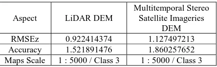
RMSEz value calculation performed to determine the vertical accuracy of each DEM has produced. RMSEz calculation is done with 90% confidence range (LE90). Table 5 presents the results of RMSEz calculation and accuracy of each DEM that have been in formed.
Aspect LiDAR DEM
Multitemporal Stereo Satellite Imageries
DEM
RMSEz 0.922414374 1.127497213
Accuracy 1.521891476 1.860257652 Maps Scale 1 : 5000 / Class 3 1 : 5000 / Class 3 Table 5. Vertical accuracy comparison between Multitemporal
Stereo Satellite Imageries and LiDAR DEM
RMSEz of LiDAR DEM is 0.92241m, while Multitemporal Stereo Satellite Imageries is 1.127497m. There are differences in both the RMSEz value DEM generated. LiDAR DEM has better RMSEz value than Multitemporal Stereo Satellite Imageries DEM. The vertical accuracy calculations performed at a 90% confidence range (LE90) with 1.6499 multiplier value. Vertical accuracy calculations show that the LiDAR DEM has vertical accuracy 1.52189m and 1.860257m for Multitemporal Stereo Satellite Imageries DEM. Based on Geospatial Information Agency of Indonesia, LiDAR DEM and Multitemporal Stereo Satellite Imageries DEM can be used to manufacture the base map scale of 1: 5000 Grade 3.
These results indicate that the DEM result of Multitemporal Stereo Satellite Imageries has an accuracy that is not much different from LiDAR DEM accuracy on a flat surface and can be used to provide altitude information (contour) on a base maps scale of 1: 5000 Class 3.
6. CONCLUSION
This research paper found that Multitemporal Stereo Satellite Imageries DEM has difference high value from LiDAR DEM. The majority of the differences high value is one meter on a flat area. Beside that, this research paper also found that Multitemporal Stereo Satellite Imageries DEM has difference RMSEz value from LiDAR DEM. LiDAR DEM has better RMSEz value than Multitemporal Stereo Satellite Imageries DEM. The differences RMSEz value is 0.2m. Base on vertical accuracy, Multitemporal Stereo Satellite Imageries DEM has equal vertical accuracy compared to LiDAR DEM on the flat surface. The vertical accuracy of each DEM in range 1.5m to 2.0m. Acoording to Geospatial Information Agency of Indonesia these DEM can be used to create contour on base map scale of 1 : 5000 Class 3.
REFERENCES
BIG, 2014. Technical Guidelines of Basic Map. Regulation of Head Geospatial Information Agency of Indonesia.
Ebner, H., Reinhardt, W. and Hobler, R. 1988. Generation, Management and Utilization of High Fidelity Digital Terrain Models. XVIth ISPRS Congress Technical Commission III: Mathematical Analysis of Data Supplements, 27 Part B3, pp. 556-566.
Jacobsen, K. 2003. DEM Generation from Satellite Data. European Association of Remote Sensing Laboratories Ghent, pp. 273-276.
Kang, J. M., Yoon, H. C. and Park, J. K. 2008. Evaluation of Possibility of Ortho Imagery Production Using SPOT 5 Single Image. XXIst ISPRS Congress Technical Commission IV, 37 Part B4, pp. 1279-1282.
Li, Zhilin, Zhu, Q. and Gold, C. 2010. Digital Terrain Modeling: Principles and Methodology, New York, CRC press. Liu, X. 2008. Airborne LiDAR for DEM Generation: Some Critical Issues. Progress in Physical Geography, 32 no1, pp. 31-49.
Nadeem, A., Ritesh, A., et al., 2006. Validation of Cartosat-1 DEM Using Differential GPS Measurements. Symposium of ISPRS Commission IV, 36 Part 4.
Narender, B., Rao, B. S., et al., 2006. Validation of C-Band SRTM Demand its Application for Orthorectification. Symposium of ISPRS Commission IV, 36 Part 4.
Srivastava, P. K., Srinivasan, T. P., et al., 2007. Recent Advances in Cartosat-1 Data Processing. ISPRS Hannover Workshop 2007: High-Resolution Earth Imaging for Geospatial Information, 36-1/W51.