DATA-DRIVEN RIGHTSIZING:
INTEGRATING PRESERVATION INTO THE
LEGACY CITIES LANDSCAPE
Emilie Evans a, Briana Grosicki b
a Director of the Rightsizing Cities Initiative, PlaceEconomics, PO Box 7529, Washington, DC 20044 – [email protected]
b Director of Research, PlaceEconomics, PO Box 7529, Washington, DC 20044 – [email protected]
KEY WORDS: Historic preservation, heritage conservation, legacy cities, rightsizing, survey, data, rapid mobile surveying
ABSTRACT:
Legacy cities, whose built environments are undergoing transformations due to population loss, are at a critical juncture in their urban history and the historic preservation ield has an important role to play. Rapid mobile surveys provide an opportunity for data collection that expands beyond traditional historic criteria, and positions preservationists to be proactive decision-makers and to align with multi-disciplinary partners. Rapid mobile surveys are being utilized in conjunction with in-depth data analysis of comprehensive livability metrics at the parcel, neighborhood, and citywide levels to develop recommendations for reactivating vacant properties. His-toric preservationists are spearheading these efforts through a tool called Relocal, which uses 70-85 distinct metrics and a community priority survey to generate parcel-level recommendations for every vacant lot and vacant building in the areas in which it is applied. Local volunteer-led rapid mobile surveys are key to gathering on-the-ground, real-time metrics that serve as Relocal’s foundation. These new survey techniques generate usable data sets for historic preservation practitioners, land banks, planners, and other entities to inform strategic rightsizing decisions across legacy cities.
1. INTRODUCTION
New approaches to data collection using smart technology are enabling heritage and land use practitioners as well as civic lead-ers to analyze, undlead-erstand, and plan for their communities in a transparent environment (Powe, 2014). In cash-strapped legacy cities that are undergoing transformation due to population loss, data-driven land use planning is even more imperative. Of pri-mary concern to legacy city stakeholders is an overabundance of vacant building stock, much of which is over 50 years old and contains character-rich, historic fabric (The Advisory Council on Historic Preservation, 2014). Preservation practitioners in these cities, who bring a wealth of knowledge centered on identify-ing and assessidentify-ing characteristics of the built environment, are positioned to aid in decision-making around where investment – in rehabilitation and demolition – makes sense. In the face of legacy city challenges, however, traditional historic preservation assessment criteria, as well as time-consuming data collection methods, can isolate preservation practitioners. As a result, pres-ervationists miss opportunities to collaborate in shaping demoli-tion and other land use decisions. To play an active role, preser-vation-oriented data collection that provides relevant metrics to planners, land bank oficials, and other decision-makers must be gathered and effectively integrated into broader planning efforts. A recent crop of preservationists are rising to meet this import-ant challenge, undertaking new rapid survey methods intended to produce more extensive data sets eficiently using smart tech -nology.
2. MAIN BODY
2.1 Traditional Historic Resource Survey Model
Historic resource surveys have long been an important method by which preservation entities inventory historic architectural assets. Primarily, these efforts are carried out with the intent to
determine eligibility for historic designation at the local, state, or national levels and the resulting data sets are managed by the city or statewide preservation agencies. The National Register Criteria, which focuses on buildings at least 50 years old, serves as the national standard when assessing properties for potential designation (Nps.gov, 2015). These criteria establish a proper-ty’s value on a building-by-building basis through the lens of its association with key historical dates, people or events of signii-cance, or unique architectural features or styles.
Traditional historic resource surveys have, historically, involved lengthy amounts of time in the ield with professional surveyors encumbered by paper, pen, and often a historic map for reference while taking notes on architectural styles and historic integrity as well as photographing or sketching the properties. Recent-ly, methods for capturing traditional historic survey data have advanced technologically, creating electronic platforms to en-courage speedier data collection in the ield.1 Increasingly, pres-ervation organizations across the country are expanding survey methodologies to include greater community input in an effort to more broadly understand places of import to local residents.2
These data sets are valuable. Collecting and utilizing this data supports preservation advocacy efforts and is the basis for
his-1 The National Park Service’s Cultural Resources GIS Facility and its Certiied Local Government (CLG) program teamed up with the City of Alexandria, Virginia in 2014 to test and develop a mobile architectural survey web-based platform that can serve as a national standard for historic resource surveying (Oaks 2014).
toric designations for individual sites and districts. Historic des-ignations can unlock inancial incentives to support redevelop -ment, such as federal or state historic preservation tax credits, or provide protection for these structures through oversight by a local historic district commission, or both (Preservation.org, 2015). But data sets resulting from these traditional surveys that use National Register Criteria as their basis have a limited scope and their intention is primarily to support historic designations and to develop a data-based foundation for preservation-plan-ning. Preservation efforts that are not “connected to the overall decision-making about a city’s economic development, public investment, and urban form – is ineffective and won’t bring the desired results (Mason 2009, 39).”
While National Register Criteria may have limited relevance beyond historic designation, assessments within the traditional historic resource survey models – such as architectural integrity, neighborhood character, and historic context – are germane to other disciplines. Integrity, speciically, speaks to “the ability of a property to convey its signiicance” through retention of origi -nal features, setting, and neighborhood (Nps.gov 2015). Connec-tions between these aspects of the built environment and qualities intrinsic to successful neighborhood development from a plan-ning perspective are not dificult to ind. The American Planplan-ning Association describes “design and architectural features that are visually interesting” as directly supporting and contributing to great neighborhood character and Richard Florida’s writing on creating quality places emphasizes the need for authenticity of buildings and history (Planning.org 2015; Florida 2012). Thus, elements like architectural integrity and neighborhood character can be highly relevant to other disciplines that deal with the built environment such as planners, developers, and land bank staff when determining a future course for buildings. It is incumbent upon preservation practitioners to help effectively translate these elements of the traditional historic preservation lexicon into col-lectable and transferable data points that are relevant to other planning efforts. To this end, the preservation ield has an op -portunity to expand the relevance of established metrics while contributing additional data points through effective collection efforts in order to assist partners in making land use decisions on the ground.
2.2 Data-Based Preservation Efforts In Legacy Cities
In legacy cities, which are addressing an abundance of vacant building stock, data collection – speciically on the built envi -ronment – plays an important role. “Legacy city” is a term used to describe urban communities with “rich histories and assets” that “have struggled to stay relevant in an ever-changing global economy (The American Assembly 2011, 0).” These older cities lourished at the height of the industrial revolution and served as hubs of manufacturing, commerce, and business. Over the last few decades, due to “signiicant population and job loss,” lega-cy cities have experienced dwindling tax bases, disinvestment in city infrastructure, and swaths of vacant and abandoned building stock in addition to “high residential vacancy and diminished service capacity and resources (Legacycities.org 2015).” Legacy cities have lost between 20-70% of their populations since 1950 (Legacycities.org 2015).
These trends are due, in part, to a combination of socio-economic transformations: suburbanization, deindustrialization, racial ten-sions, and redlining, along with many other factors. The recent (and ongoing) foreclosure crisis compounded the effects of these
trends, and has left many legacy cities reeling across the Mid-west, Mid-Atlantic, and Northeast regions (Mallach and Brach-man 2013). While Detroit, Cleveland, Buffalo, and St. Louis arise as easily identiiable examples, they share the list of top 50 legacy cities with Scranton, Utica, Louisville, and Newark (Legacycities.org 2015). In some cases, growing cities -- such as Little Rock, AR or Chicago, IL -- have neighborhoods fac-ing the same array of challenges as legacy cities. Today, legacy city communities and neighborhoods small and large are facing dificult and important decisions around their built environment – where to reinvest, where to focus demolition, and how to spend limited resources effectively.
Among their many assets, legacy cities are illed with historic buildings, walkable tree-lined neighborhoods, and are situated on lakes and riverfronts (American Assembly 2011, 5). Property values and foreclosure rates in historic districts have remained more stable than in comparable neighborhoods throughout the recent recession (Kostyu 2008; Broadbent 2011; Rypkema and Paxton 2015). A recent data-based study by the Preservation Green Lab reviewed economic, social, and environmental met-rics over building maps and found neighborhoods with a mix of older, smaller buildings score higher than areas of larger, newer structures (Preservation Green Lab 2014, 1). Tom Mayes, Dep-uty General Counsel for the National Trust for Historic Preser-vation, has written a series of essays on why old places matter, in which he states, “People in a community share a sense of its identity and character, which is often represented by the old places that serve as community landmarks (Mayes 2015).” The historic, character-rich and culturally signiicant building stock, abundant in legacy neighborhoods, is a critical asset for these communities to build on and leverage in long-term plans moving forward.
However, not all buildings can or should be saved. This is ac-knowledged even within the preservation ield (Bertron 2013). Effective rightsizing strategies must entail a balance of strategic neighborhood interventions, from preservation and rehabilita-tion to mothballing to deconstrucrehabilita-tion and demolirehabilita-tion (Bertron 2013). Rightsizing is generally referred to as the “process of change” and planning a city must do to “recalibrate” after sig-niicant population loss and resulting outcomes (The Advisory Council on Historic Preservation 2014, 1). Rightsizing entails tailoring a city’s infrastructure, footprint, and city services to align with its current and projected population (Bertron 2013). It is a term – distinct from the related term, “shrinking cities” – that implies that every city has a “right size,” and that the pro-cess of adjustment to achieve that shape is a proactive planning approach for each city’s unique size and shape, not a journey of shrinkage and decline.
While demolition is a necessary part of any rightsizing strategy, it is a tool that must be used strategically and in conjunction with other interventions on vacant properties. In 2012, Alan Mallach, then a senior fellow at the Metropolitan Policy Program with the Brookings Institution, agreed, stating: “Given both the critical need for large-scale demolition in many older communities, the costs associated with it, and the limited resources available, poli-cymakers and practitioners need to be strategic in their decisions about which buildings to demolish, and in what areas... (5)”
demo-lition and reinvestment (Dale 2013). This data is being collected using smart technology in speedy and eficient ways, and incor -porating data from across disciplines to spur informed decisions. Oftentimes, this data is held in an online platform for greater transparency and cross-discipline utility of the data.
demolition, and other land use decisions were being made based on outdated information. ScoutMuncie’s intention was to gather needed information on every building in the city, including archi-tectural character and building condition (ScoutMuncie, 2016). The survey captured heritage- and building-based metrics, and used the data for future historic designations, but also an array of data that informs other city agencies and decision-makers including sidewalk condition and illegal dumping. This project recognizes that data is critical to informing city and neighbor-hood decisions and preservation is one element in maintaining a vibrant, healthy city -- and that preservation entities can be the initiators and leaders of these projects.
Heritage metrics -- such as architectural character or integrity, construction quality, and building condition -- have a strong role to play in guiding decision-making through data. These charac-teristics and assessments provide vital information on which to base decisions regarding demolition or other interventions, such as deconstruction or mothballing. But heritage-based metrics alone do not paint a full and complete picture of the viability and stability of blocks and neighborhoods. These heritage- and building-oriented metrics must be analyzed in conjunction with an array of other metrics that help decision-makers understand the livability of areas at multiple levels.
For example, in Detroit, Michigan, the 2013-2014 Motor City Mapping survey – led by Loveland Technologies, Data Driven Detroit, and the Detroit Blight Task Force – surveyed every par-cel of land in the city in order to get a handle on current condi-tions for both lots and structures. Using tablets in the ield, over 100 surveyors logged data for roughly 380,000 parcels over the course of two months (Austen 2014). Questions included wheth-er propwheth-erty was open and in need of boarding, whethwheth-er thwheth-ere was dumping on site, and what the building condition was. The re-sulting data was layered with ire department incidents, water shut-offs, postal service, and other data sets, which informed decisions by the Detroit Land Bank Authority and other entities.
To add a preservation-based data layer to Motor City Mapping, the Michigan Historic Preservation Network and Preservation Detroit teamed up to lead the Detroit Historic Resource Survey (DHRS). Nearly 50 volunteers used smartphones to gather in-formation on architectural integrity, neighborhood character, and block intactness for nearly 18,000 vulnerable historic buildings in Detroit in order to provide a complementary data set to Motor City Mapping to inform demolition decisions in Detroit. The De-troit Land Bank Authority -- who ultimately made those demoli-tion decisions -- utilized the DHRS data layer along with Motor City Mapping, and the DHRS data is now mapped openly on Data Driven Detroit’s website.
In 2015 in Muncie, Indiana, the Historic Preservation Commis-sion initiated a citywide rapid mobile survey titled ScoutMuncie. Muncie had not had a traditional historic resource survey since 1985 and was not scheduled to again until 2021. Preservation,
Figure 1. Screenshot of Detroit’s Motor City Mapping inter-active website, a result of the Data Driven Detroit initiative
(Source: Motor City Mapping, 2017)
Figure 2. DHRS surveyor using her smartphone to monitor survey results coming in from other surveyors in the ield
(Photo Credit: Amy Elliott Bragg)
Figure 3. Results of ScoutMuncie for the downtown area of Muncie illustrating the percentage of unproductive properties (vacant buildings and vacant lots) and wealth of architecturally
signiicant resources within (Source: ScoutMuncie, 2017)
Historic preservation practitioners are positioned to aid in the development of such metrics and even in their collection along-side land banks, planning agencies, and neighborhood groups. Innovative thinkers in the ield recognize that swift collection of data allows preservation practitioners “to develop and imple-ment new survey tools that use smartphones and tablets to cat-alog resources,” “creates new opportunities to demonstrate how older buildings support sustainability and vitality,” and “can be used to present information about the historic resources of com-munities in novel, alluring ways that engage large public audi-ences (Powe 2014).”
Largely, though, historic preservation’s role within rightsizing initiatives – in particular around demolition decisions – has been relegated to responding to local historic properties up for demo-lition or Section 106 review of properties lagged when federal funding is used for the same purpose. This positioning consigns preservation practitioners to be reactive to projects already in de-velopment pipeline. From a regulatory perspective, an approval from the preservation agency is seen solely as a checkbox need-ed to move forward with denial perceivneed-ed as preservationists standing in the way of progress. In these scenarios, the relevance of historic preservation in a rightsizing and legacy city context is questioned and its practitioners excluded from earlier inclusion in broader decision-making efforts. Using new data points and collection methods, preservationists stand to play a more proac-tive role helping to inform decisions around these interventions as part of broader rightsizing strategies.
2.3 Relocal And The Role Of Preservation And Rapid Mo-bile Surveys In Holistic Neighborhood Analysis
Entities within Muncie, Indiana; Cincinnati, Ohio; and Little Rock, Arkansas sought assistance collecting data and develop-ing strategies for dealdevelop-ing with vacant and abandoned properties through Relocal, a data-based tool developed by the Rightsiz-ing Cities Initiative at PlaceEconomics in 2012. Relocal offers parcel- and neighborhood-level recommendations for integrating vacant and abandoned properties into long-range revitalization plans (Bertron and Rypkema 2015). Relocal utilizes between 70-85 distinct metrics -- depending on the availability of sets -- including data points from a volunteer-driven rapid mobile ield survey and a community priority survey in order to analyze neighborhood strengths and challenges.
The rapid mobile ield survey, which utilizes a web-based sur -vey platform, collects data on building condition, architectural character, building quality, vacant lot usage, grafiti, and more. Additional data metrics Relocal utilizes range from voter reg-istration and density potential to sidewalk condition and public transportation to household purchasing power and foreclosures. These comprehensive metrics are grouped across eight catego-ries that include Real Estate, Stability, Neighborhood Character, Walkability, Fiscal Responsibility, Economic Opportunity, En-gagement, and Environment. The community priority survey is distributed to local residents through organizations on the ground and identiies which neighborhood characteristics residents val -ue most. These results are then weighted in the backend analysis used to inform recommendations (Bertron and Rypkema 2015).
This wide range of comprehensive metrics incorporates heri-tage-based elements into a broader matrix that assesses myriad pieces that go together to make parcels, blocks, and neighbor-hoods viable, stable, and desirable places to live, work, and play.
The subsequent analysis of all metrics plus the community prior-ity survey yields parcel-level recommendations for every vacant building and vacant lot in the study areas within the cities where it is applied. For vacant buildings, recommendations include re-habilitation, stabilization, demolition/deconstruction, and defer decision. For vacant lots, recommendations include inill con -struction, environmental reuse, contributory reuse (such as a pocket park or side lot split), and defer decision (Rightsizing Cit-ies Initiative, PlaceEconomics 2015). For both vacant buildings and lots, “defer decision” suggests that no clear recommendation emerged for these properties at that time, and in addition, limited funding will be well spent on the three other recommendation categories.
Muncie served as Relocal’s pilot project and, in partnership with the City of Muncie and Ball State University’s Historic Preser-vation Program, PlaceEconomics analyzed ive neighborhoods across the city. A team of ten trained volunteers surveyed over 4,000 properties in three days utilizing LocalData’s web-based smartphone survey platform to gather data on the built environ-ment. The City of Muncie Historic Preservation Commission and neighborhood groups are using the neighborhood-level ind -ings and recommendations to inform decision-making.
In Cincinnati, Ohio, the Walnut Hills Redevelopment Foundation and the Cincinnati Preservation Association partnered to fund a Relocal analysis in the Walnut Hills neighborhood. Following the pilot study in Muncie, the Relocal analysis was tweaked to include tailored ield survey questions and increased emphasis on the community priority survey. Members of the Cincinnati Pres-ervation Association, the Cincinnati PresPres-ervation Collective, and the Walnut Hills Redevelopment Foundation with experience in architecture, planning, or preservation served as volunteers. The trained volunteers surveyed over 5,000 properties in three days using the same smartphone survey platform. The organizations in Walnut Hills are currently utilizing the dataset and parcel-lev-el recommendations to guide short-term investment decisions and long-term partnerships.
And in Little Rock, Arkansas -- a city that on paper continues to grow due to annexation -- irst ring older and historic neigh -borhoods have been suffering declining populations, vacant and
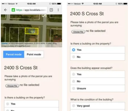
Figure 4. Screenshots of the web-based LocalData survey plat-form utilized in the Relocal projects
neglected buildings, and economic disinvestment for decades. Relocal was applied to provide a strategic approach forward for vacant properties using the city’s limited funding. Nearly 8,000 parcels were surveyed using the LocalData’s rapid mobile sur-vey platform and working with nearly 50 local resident volun-teers. Of those parcels, nearly 2,400 were either vacant buildings or vacant lots, each of which received a parcel-level recommen-dation for how to move that property forward into productive use. Today, the City of Little Rock is implementing those recom-mendations in conjunction with the relevant city agencies and organizations on the ground.
mobile survey projects provide methodologies to build upon for future data collection efforts.
The Relocal tool uses smart technology to conduct an expedient ield survey that recognizes the value of incorporating built envi -ronment characteristics such as architectural integrity and build-ing condition into local plannbuild-ing decisions. While the DHRS and ScoutMuncie provide a preservation-focused data set to incor-porate into other planning and data collection efforts, Relocal incorporates many of these same metrics into a comprehensive compendium of metrics that more holistically measures quali-ties of neighborhoods and properquali-ties. Importantly, a key element of the Relocal tool is its parcel-level recommendations derived from analysis. The DHRS and ScoutMuncie are models for in-corporating preservation-focused data points into larger strategic planning efforts and are intended to help inform decision-mak-ing through data, but they do not make parcel-level recommen-dations.
Each of these projects serve as a model for how preservationists can proactively engage in legacy city demolition decision-mak-ing with partners across ields. By workdecision-mak-ing with planndecision-mak-ing and land bank partners from the onset, the project and its indings were positioned for integration into planning efforts at its con-clusion more easily. Both ScoutMuncie and DHRS developed in response to a speciic set of conditions: the DHRS to a sub -stantial sum of funding for demolition that had no preservation oversight as well as to provide a complementary data set for decision-makers, and ScoutMuncie to gather important data in Muncie that would inform decision-making by preservation, planning, code enforcement, and other city agencies. Both serve as highly applicable models for future adaptation.
Relocal, however, is a tool (rather than a model) that incorpo-rates rapid mobile surveying with comprehensive data collec-tion efforts along with recommendacollec-tions that integrate historic resources into long-range planning, which includes myriad other neighborhood and livability metrics. It also takes into account context of local funding streams and connectivity to other local or regional plans. Like the DHRS and ScoutMuncie, Relocal’s applications on the ground create opportunities for future com-parisons and analysis as more rapid mobile survey and compre-hensive data-based models emerge to enable informed planning for legacy cities.
4. CONCLUSION
Legacy cities are facing unprecedented challenges. Strategic rightsizing decisions require tactical utilization of data to sup-port myriad neighborhood interventions across legacy cities and their neighborhoods. To stay relevant in the changing landscape of legacy cities, the ield of historic preservation must develop innovative tools and partnerships to address these unique built environments. Tools like Relocal and models like the Detroit Historic Resource Survey and ScoutMuncie provide some exam-ples for how to identify and leverage built assets to make smart reinvestment decisions moving forward.
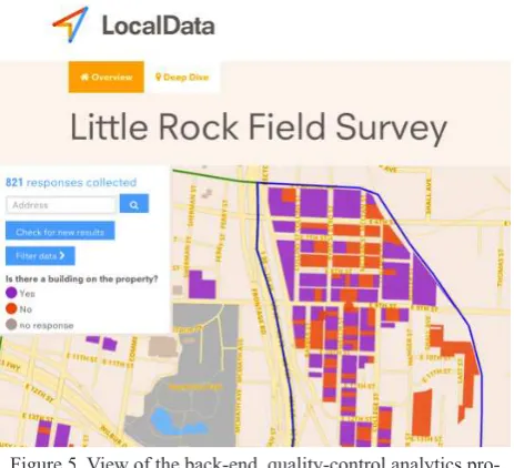
Figure 5. View of the back-end, quality-control analytics pro-cess during the Little Rock Relocal project (Source: PlaceEconomics and LocalData, 2015)
Figure 6. Relocal recommendation maps for vacant buildings (left) and vacant lots (right) in the neighborhood surrounding
Central High School in Little Rock, Arkansas (Source: PlaceEconomics, 2015)
3. ANALYSIS
REFERENCES
Atassi, Leila. 2013. ‘Proposed Federal Legislation Could Gener-ate Millions Of Dollars For Demolition In Cleveland’. The Plain Dealer. http://www.cleveland.com/cityhall/index.ssf/2013/02/ proposed_federal_legislation_c.html.
Austen, Ben. 2014. ‘The Post-Post-Apocalyptic Detroit’. The New York Times. http://www.nytimes.com/2014/07/13/maga-zine/the-post-post-apocalyptic-detroit.html?_r=0. Accessed Jan 7, 2017.
Bertron, Cara. 2012. Character Study Project: Developing A New Type Of Historic Resource Survey. Philadelphia: University of Pennsylvania School of Design.
Bertron, Cara. 2013. ‘Rightsizing Right’. Forum 24 (4): 23-33.
Bertron, Cara, and Donovan Rypkema. 2015. Transforming Va-cancy In Walnut Hills. PlaceEconomics.
Brachman, Lavea, and Alan Mallach. 2013. ‘Op-Ed: ‘Demoli-tion’ Is Not A Bad Word — Just Keep It Strategic’. Next City. http://nextcity.org/daily/entry/for-legacy-cities-demolition-is-not-a-bad-word-just-keep-it-strategic#.Ujb0eQJ6Boc.email.
Bragg, Amy. 2014. ‘Urgent Call To Action! Volunteers Needed For Critical Neighborhoods Survey - Preservation Detroit’. Pres-ervation Detroit. http://presPres-ervationdetroit.org/urgent-call-to-ac- http://preservationdetroit.org/urgent-call-to-ac-tion-volunteers-needed-for-critical-neighborhoods-survey/.
Broadbent, Kimberly A. 2015. Assessing The Impact Of Local Historic District Designation On Mortgage Foreclosure Rates: The Case Of Philadelphia. Philadelphia: University of Penn-sylvania. http://repository.upenn.edu/cgi/viewcontent.cgi?arti-cle=1164&context=hp_theses.
Co.lucas.oh.us,. 2015. ‘Lucas County, OH - Oficial Web -site - The Toledo Survey’. http://co.lucas.oh.us/index.aspx-?NID=2783. Accessed Jan 7, 2017.
Dale, Brady. 2013. ‘Chicago’s Land Bank Will Use Big Data To Target Vacant Homes’. Next City. http://nextcity.org/daily/entry/ applying-big-data-to-vacants-and-other-steps-taken-by-chica-gos-land-bank. Accessed Jan 3, 2017.
Davidson, Kate. 2013. ‘States Divert Foreclosure Prevention Money To Demolitions’. Marketplace Economy. http://www. marketplace.org/topics/economy/states-divert-foreclosure-pre-vention-money-demolitions.
Department of Administration, Finance, Policy and Urban Af-fairs,. 2007. Mayor Brown’s “5 In 5” Demolition Plan. Buffalo: City of Buffalo.
Detroit Blight Removal Task Force,. 2014. Every Neighborhood Has A Future... And It Doesn’t Include Blight..
Detroit. http://report.timetoendblight.org/index.html.
Discoverdenver.co,. 2015. ‘DISCOVERDENVER.CO’. http:// www.discoverdenver.co/.
Evans, Emilie. 2014. ‘Integrity, Character & Intactness: A Pres-ervation Survey Model For Legacy Cities’. Urban Inill 7: 75-79.
Evans, Emilie, Donovan Rypkema, and Briana Grosicki. A Way Forward: Strategies and Tools for Addressing Vacancy in
Lit-tle Rock. February 2016. Findings from PlaceEconomics’ LitLit-tle Rock Relocal project.
Florida, Richard. 2012. ‘What Draws Creative People? Quali-ty Of Place’. Urban Land Magazine. http://urbanland.uli.org/ industry-sectors/what-draws-creative-people-quality-of-place/.
Huduser.org,. 2014. ‘Vacant And Abandoned Properties: Turning Liabilities Into Assets | HUD USER’. http://www.huduser.org/ portal/periodicals/em/winter14/highlight1.html.
Griswold, Nigel G., and Patricia E. Norris. 2007. Economic Impacts Of Residential Property Abandonment And The Gen-esee County Land Bank In Flint, Michigan. Michigan State University Land Policy Institute. http://community-wealth.org/ sites/clone.community-wealth.org/iles/downloads/report-gris -wold-norris.pdf.
KAPSZUKIEWICZ, WADE. 2015. ‘Toledo Housing Survey Of-fers A Basis For Smart Use Of Tax Dollars’. The Blade. http:// www.toledoblade.com/Opinion/2015/06/07/Toledo-housing-survey-offers-a-basis-for-smart-use-of-tax-dollars.html.
Kostyu, Paul E. 2008. ‘Properties In City’s Historical Districts Show Stability, Investment Opportunity In Roiled Market’. Co-lumbus Business First. http://www.bizjournals.com/coCo-lumbus/ stories/2008/12/08/focus1.html.
Legacycities.org,. 2015. ‘Legacy Cities Partnership’. http:// www.legacycities.org. 4 Mar. 2015.
Loveland Technologies. “Motor City Mapping.” Motor City Mapping. Accessed Jan 20, 2017.
Mallach, Alan. 2012. Laying The Groundwork For Change: Demolition, Urban Strategy, And Policy Reform. Washington, D.C.: Brookings Metropolitan Policy Program.
Mallach, Alan, and Lavea Brachman. 2013. Regenerating Amer-ica’S Legacy Cities. Policy Focus Report. Cambridge: Lincoln Institute of Land Policy. https://www.lincolninst.edu/pubs/2215_ Regenerating-America-s-Legacy-Cities.
Mallach, Alan. 2014. ‘Hardest Hit Funds Demolition Pol-icy Change On Track To Become A Boon For Distressed Communities. Blog. Community Progress Blog. http://www. communityprogress.net/blog/federal-policy-change-leads-re-sults-ground-hardest-hit-funds-demolish-derelict-houses.
Mason, Randall F. 2009. ‘Preservation Planning In American Cities’. Forum Journal Winter: 39.
Mayes, Tom. 2015. ‘Why Do Old Places Matter? Community’. Blog. Preservation Leadership Forum. http://blog.preserva-tionleadershipforum.org/2015/03/10/old-places-community/#. VX2dNVVViko.
National Trust for Historic Preservation | Preservation Green Lab,. 2014. Older, Smaller, Better: Measuring How The
Char-acter Of Buildings And Blocks Inluences Urban Vitality. Seat-tle: National Trust for Historic Preservation. http://www.preser-vationnation.org/information-center/sustainable-communities/ green-lab/oldersmallerbetter/report/NTHP_PGL_OlderSmaller-Better_ReportOnly.pdf.
Bulletin (NRB 15)’. Accessed Jan 10, 2017. http://www.nps.gov/ nr/publications/bulletins/nrb15/nrb15_2.htm.
Oaks, Michele. 2014. ‘Historic Resource Survey With Mobile Technology: A Case Study In Alexandria, Virginia’. Blog. Pres-ervation Forum Blog. http://blog.presPres-ervationleadershipforum. org/2014/08/21/historic-resource-survey/#.VX4th1VVikp.
Placeeconomics.com,. 2015. ‘Rightsizing’. Accessed Jan 11, 2017.http://www.placeeconomics.com/rightsizing.
Planning.org,. 2015. ‘Characteristics And Guidelines Of Great Neighborhoods’. Accessed Jan 9, 2017. https://www.planning. org/greatplaces/neighborhoods/characteristics.htm.
Powe, Mike. 2014. ‘Big Data: A New Frontier In Historic Pres-ervation?’. Blog. Preservation Leadership Forum. http://blog. preservationleadershipforum.org/2014/03/04/big-data-osb/#. VX4uOVVVikq.
Preservation.org. 2015. ‘Economic Beneits Of Preservation’. Accessed Jan 10, 2017. http://www.preservation.org/rypkema. htm.
Preservation Action,. 2013. ‘Hardest Hit Fund Ok’D For Dem-olition Costs; Tax Reform Threatens Historic Tax Credits; Rep. Garamendi Joins Caucus’. http://www.preservationaction.org/ hardest-hit-fund-used-for-demolition-tax-reform-threat-htc-ga-ramendi-joins-caucus/.
Rightsizing Cities Initiative, PlaceEconomics,. 2015. Stronger Neighborhoods Through Strategic Decisions: Relocal Tool. Pla-ceEconomics. Accessed Jan 7, 2017.
Rypkema, Donovan, and Briana Paxton. 2015. Historic Preser-vation: Part Of The DNA Of Pittsburgh. PlaceEconomics. Ac-cessed Jan 9, 2017.
Scoutmuncie. 2016. Results, Survey Map and Data. Accessed January 20, 2017. https://scoutmuncie.wordpress.com/.
The Advisory Council on Historic Preservation,. 2014. Manag-ing Change: Preservation And RightsizManag-ing In America. The Ad-visory Council on Historic Preservation. http://www.achp.gov/ RightsizingReport.pdf.
The American Assembly,. 2011. Reinventing America’s Legacy Cities: Strategies For Cities Losing Population. The American Assembly. http://americanassembly.org/publications/reinvent-ing-americas-legacy-cities-strategies-cities-losing-population.
Western Reserve Land Conservancy,. 2015. Estimating The Ef-fect Of Demolishing Distressed Structures In Cleveland, OH, 2009-2013: Impacts On Real Estate Equity And Mortgage-Fore-closure. Cleveland: Thriving Communities Institute. Accessed June 3. http://www.thrivingcommunitiesinstitute.org/docu-ments/FinalReportwithExecSummary_modiied.pdf.