423 UNDERSTANDING RESIDENT’S PREFERENCES FOR MORE
SUSTAINABLE HOUSING DEVELOPMENT IN RIPARIAN MUSI, PALEMBANG
Maya Fitri1,2*, Sugeng Triyadi1, Ismet B Harun1
1 becoming the problem for city ecological sustainability. In Palembang, the riparian area at Musi River has been being overcrowded by the slum settlements. Unplanned landed houses almost cover all this natural riparian area. This paper studies about the Musi riparian resident’s preferences for more sustainable development. It does by examining their acceptability of more compact housing mass and greater green space. This study used the conjoint analysis as stated preference method. A comprehensive survey was done in settlements on both sides of Musi River. The survey configured a set of choice cards as a part of the questionnaire for investigating the central hypothesis of how slum residents made trade-offs between attributes property. The findings suggest that most households prefer a row house with medium-size riverbanks open space rather than an apartment with the large open space.
Keywords: Residential preference; Urban Riparian; Sustainable Development.
1. INTRODUCTION
Riparian is wetland located in the area along the bank of the river and directly affected by the river waters tidal. The surface flow occurs in this area. It is located in floodplains adjacent to rivers or streams and is occasionally flooded by rivers or streams. The flooding of riparian varies in intensity, duration, and some floods from year to year, although the probability of flooding is predictable (Mitch & Gosselinks, Wetlands, 1993).
The riparian ecosystem has an important function as natural resources. Not only its function as ecosystem services but also its existence provides a unique character for the city. In the traditional view, riparian-like the others wetlands are a wasteland. Words like marsh swamp, bog, and fen imply little more than dampness, disease, difficulty, and danger. Such wasted lands can be put to good use, however, if they are ‘‘reclaimed’’ for agriculture and building. However, in fact, it is far from being wastelands, wetlands are the most fertile and productive ecosystems of the world. Its are essential life-support systems, play a vital role in controlling water cycles, and help to clean up our environment as biofilters. Furthermore, as the transition area, riparian maintains the balance between two ecosystems, land, and river. Naturally, riparian is function as a filter to precipitate water runoff from land to river.
The topography of Palembang city built on flat plains similar like the lagoon. It is like a transition land between the west of Sumatra plateau and the ocean on the east. It is
*Corresponding author’s email:
424 located in the flat and lowland, the spread of surface water inundates almost the entire plains. As a result, it created hundreds of streams that flow into this city.
The streams overflow flooding the surrounding area. Furthermore, Palembang historical city center was founded on riverbanks of Musi River. Musi River has an average width of 540 m with the deepest into only 20 m. The almost flat topography makes its surrounding area always inundated by the tidal. That area is called the Musi Riparian. Currently, the settlement areas on riparian Musi have been developed into dense and slum settlements. The Palembang housing problems generated from rapid development in urban areas. The main problem is the increasing needs for new housing. On the other hand, there is the scarcity of available built-up land for housing developments because the geographic condition. Consequently, the growing city population has registered a significant expansion of its built-up areas through the wetland areas like marshes and riparians. This kind development practices cause environmental damage, such as increased flood point, the decline in the quality and quantity of water resources, and loss of natural biodiversity.
One of the principles is to reduce the damage to its ecosystem by minimizing the size of built area. This article focuses on the resident’s acceptability of more sustainable urban riparian development through compactness mass and greater green space area. This study method used the conjoint analysis as the preference method. A comprehensive survey in two squatter settlements on both sides of the river Musi provided contextual data on the socioeconomic marginalization of the respondents and a stated preference choice model. It was used for configuring a set of choice cards as a part of the questionnaire and provided data for investigating the central hypothesis of how slum residents made trade-offs between attributes property.
2. THE PRINCIPLE OF RESIDENTIAL DEVELOPMENT IN URBAN WETLAND
The research explored principles relating to the construction with the ecosystem approach. Currently, the theory of urban planning and spatial city development has not been integrated with the preservation of the natural site hydrology and the water balance on urban(Woltjer & Al, 2007). The discussion of the hydrology and the ecology conservation more emphasis on the conservation of wetlands without further discuss the techniques to integration on urban design components. Therefore, these principles are elaborated through several theories related to urban spatial design, urban water resource management, and wetlands restoration such as Ramsar Conventions, Low Impact Development (LID), Total management of the Urban Water Cycle (TMUWC), Soft Path for Water (SPW), and the wetlands’ restoration.
425 area. In addition, buffer areas block pollutants that directly flow into water bodies. Riparian ecosystems have a special flora and fauna habitats. They have adapted to the ecology of wetlands that have fluctuations from wet to dry conditions annually. The natural flora and fauna are very effective to absorb pollutant and function as the water purifier. The maintaining the natural ecosystem of the riparian land structure is important to improve the ability of the land to absorb overflow of river water that protects the mainland from flooding (Newham, Fellows, & Sheldon, 2011).
3. RESEARCH DESIGN
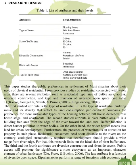
Table 1. List of attributes and their levels
Attributes Level Attributes needs of physical residential. From previous studies on residential connected with water area, there are several attributes, such as residential type, size of buffer area, access, riverside construction, and type and function of riverside open space (see table 1) (Kauko, Goetgeluk, Straub, & Primus, 2003) (Singelenberg, 2008).
426 social value to people. Riparian buffer area has potential space for human activities or ecology conservation (Beal, 2007).
This study method used the conjoint analysis as the preference method. To simplify the collection of survey data, we created an orthogonal fraction factorial experimental design. The use of fractional-factorial designs brings back the number of constructed profiles to manageable proportions (Molin, 2011). The survey is consisted on five attribute profiles (see Table 1). The result is 16 profiles to rating by respondent.
Settlements with occupancy can be seen as a collection of attributes. A selection of residential and environment have characteristics that can be seen as a choice of attributes. It is an important attribute that affects the stimulus affect, cognition, and behavior of a person. Respondents will evaluate the products of the residential based on their values, culture, and experiences. As in housing property market, prospective buyers will evaluate the attributes of this house before deciding to buy the residential product.
These attributes have the significance for decisions a person's preference. Each attribute has an important value that is different for each person. An important attribute gets more attention from consumers. The more important of these attributes, the greater attention to these attributes. Product makers or planning authority need to know the attributes that have the most important value for a person and the amount of its attribute values. For subsequent, manufacturers and planner can formulate the combination of these attributes in order to satisfy consumer preferences.
In the conjoint analysis, attributes measured by category and function usefulness containing allegations part worth or also called utility function. The usefulness or utility is associated with the level or levels of a person's preference. Observation of the responses made to the part-worth utility contained in each level attributes that influence the level of consumer preferences on a given attribute. To determine the effect, analyzes such as statistical techniques such as regression and logit used. The analytical procedures used in this study are the method of regression with dummy variables. The general basic model of conjoint analysis with the analysis procedure is (Molin, 2011):
Where,
Uj = overall utility attached to alternative j;
V j = the structural component of utility; that part of the utility that is determined by the model;
Ɛ j = an error component or random part of utility; that part of utility that is not determined by the model;
427 many different acts of building, all of which is carried out with similar rules and goals. Type of settlements like this almost the entire existing land uses. The possibilities that can be done to obtain additional green land is by compressing the settlement into a more compact building. Currently, in this district don't exist an apartment building. People are still not familiar with the type of building. This study is to determine whether the respondent can accept the type of apartment.
Figure 1 Map and Pictures of Musi River in Palembang City with Districts Included in the Survey
This study took samples on both sides of the river Musi. It is intended to compare the influence of development dichotomy on people's preferences. The Music River divides Palembang city. Those sides are called Ilir and Ulu area. On it’s both sides, the Palembang city early settlements evolved. Both are the historic water residential that turned into slums area when urban development had oriented into inland. Nevertheless, there are still typical historic vernacular houses standing with new houses that are low-quality structures and lack of municipal water taps. By time goes by, there is a gap in the development of both sides of the city. Development in the Ilir is better than the Ulu. The slightly higher topography, easiness accessibility and better socioeconomic creates a more conducive development condition in the Ilir area.
Most of Musi Riparian edges are still natural landscape without engineered wall river. As the floodplain area, flooding is a natural event. Community creativities construct the built environment to accommodate their routine activities. There is no buffer area between settlement and stream because people built houses through the body of the river. The majority of populations are vulnerable to the risks of flood events. The observation result showed that main house type is the attached building, but a distance between buildings is less than two meters or even none, so it is looked like row houses. The percentage of this kind of buildings is nearly sixty percent of all houses. People built a house on typical wetland foundation, namely stilt and raft.
428 This community uses small traditional boats equipped with motors to cross over other riverside or down to the area along the river banks. The larger boats transport commodities from producing areas to be sold in a city marketplace. The land accessibility of this area is very limited. Many circulation paths are disconnected, narrow and winding so it only can be used as pedestrian.
Preliminary survey results determine the area Limo Ulu and Tigolimo Ilir as case studies of this research. The total sample of respondents from both areas Tigolimo Ilir and Limo Ulu are 320 people. The study took 160 samples of respondents of each area. The sample limited to respondents who had a house within 250 meters from the riverbank. The consideration is that the tide of the river still has greatly influenced by the development of settlements in this area as well as their daily activities are also strongly connected with the river. There are a few samples were incomplete, so it cannot be used as the data analysis. However, the minimum number data analysis has been fulfilled.
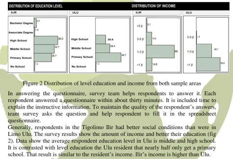
Figure 2 Distribution of level education and income from both sample areas
In answering the questionnaire, survey team helps respondents to answer it. Each respondent answered a questionnaire within about thirty minutes. It is included time to explain the instructive information. To maintain the quality of the respondent’s answers, team survey asks the question and help respondent to fill it in the spreadsheet questionnaire.
Generally, respondents in the Tigolimo Ilir had better social conditions than were in Limo Ulu. The survey results show the amount of income and better their education (fig 2). Data show the average respondent education level in Ulu is middle and high school. It is contrasted with level education the Ulu resident that nearly half only get a primary school. That result is similar to the resident’sincome. Ilir’s income is higher than Ulu.
5. THE RESIDENTIAL PREFERENCE
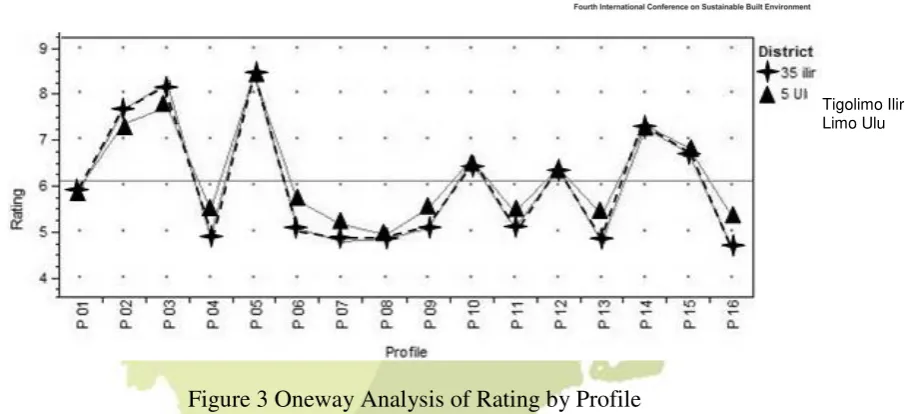
429 Figure 3 Oneway Analysis of Rating by Profile
Figure 3 shows the preference level of groups respondent Limo Ulu and Tigolimo Ilir for each profile option. The x-axis is the data from 16 profiles with numbers 1 through 16. The axis y is the preference evaluation with the scale of 1-10. The level scale 1 is the option that has the lowest preference value, while the 10 is the highest preference. The survey explains that the average scale public preference only range among 4-9 and an average value is 6,5.
The analysis results showed that the preferences of the respondents in both regions are similar. No significant difference occurred because the second comparison value is approaching one. It means there are no significant difference preferences for both groups option.
Conjoint analysis is to examine simultaneously the influence of some free variable depending on several variables. In the data collection techniques rating, the measurement interval is presumed as a measurement variable. Assessment of the observed attribute is dependent variable in the regression analysis and the independent variable was formed by code level of attribute level. In this study, researchers analyzed the data with the help of using JMP software into a multivariate regression analysis. To be able to analyze the data depend on the lot with a multivariate regression analysis, the dependent variable data should be combined into one column variable to get one variable depends on several free variables.
The study used multivariate regression analysis to determine the effect of each attribute and attribute level to the preferences of the respondents. This analysis compares the strength of the influence of some dependent variables to the independent variable. Thus, the dominant variable, less dominant or non-dominant influence due to the variable will be known. The higher value of the regression coefficient (commonly called regression weight) is the greater influence on the independent variables.
Regression weights each variable is written in the cause’s column part worth utility. Results of the analysis revealed a significant probability if (Prob> F) is smaller than 0.0305 (JMP, A Business Unit of SAS, 2007). In this study, the analysis results are very significant because the overall probability is <0.0001.
In Table 2 shows that the type mass has a very important value up to 69,1 % of the respondent’s decision and the row house attribute has the most influence on respondent preference. Its value is a positive 1,35. On the contrary, the floating house has the negative 1,32. It implies that the type of row house increases people's preference, whereas the type of floating houses decreases people's preference for the residential
430 profile. Type apartments have a value nearly neutral to slightly negative towards 0,03. The apartment attribute effect is not significantly affecting preferences.
Table 2. Estimated part-worth utilities
The surprising result was obtained from the width of river buffer area. Most respondents like the wider buffer area. This attribute has the important value 8,1% of the overall respondent consideration. The preference gradually increases from +0,039 point to width of less than 10 m to the width 10-20 m. Preferences increased again by + 0,079 points to the width 20-30 m wide than it. However, preference incrementally dropped by 0,31 point if the width more than 30 m.
Respondents also had a clear preference riverside construction that most preferred is waterfront platform (0,170). Polder value is not significant but tends to neutral. The surprising outcome is shown from the result of riverside access attributes. The positive values for all preference value each group indicates that the communities may be more choose the boat dock than the promenade as the area network. Playground field is the function of open space is preferred as the most preference (0,268). The results are very significant. Two others options have a negative point that implicates it decrease people's preference of housing profile.
6. CONCLUSION
431 products. The natural environment in the riparian area shapes the value and culture of the waterfront communities with similar preferences housing.
The findings suggest that mostly respondent prefers to the row house and medium size of the buffer as the most preferred house profile. It suggests that majority respondents preferences are substantially out of alignment with the principle of sustainable urban wetland development. Most households do not feel familiar to live at higher vertical densities without directly landed access. The ecological settlement is the minimally developed land. The profile that fit these criteria is the apartment with a very large buffer, but it was rarely preferred. Development should be planned with storey landed house that more compact with higher density.
The existing settlement appears to the river edge, but communities prefer size 20-30 m buffer area. This is an opportunity for planning these riverside settlements to have a wider buffer area. It is not only the ideal size for giving security from water waves or flooding but also ideal for ecology. The wider buffer area between the housing to the river provides better ecological functions. It is also potential for green or public open space to the city. Besides functioning as a barrier to pollution, its ideal size gives sufficient size green space area as a river flow catchment areas that are urgently needed especially when flooding during the rainy season with tidal rivers.
The choice of river banks construction is influenced by the safety factor of flooding risk. The option of riverside construction like waterfront platform will increase their preference because it provides the additional advantage of free flood plains that could be used for communal activities and still closeness to the river.
The analysis result shows that a docked boat is a more preferred transportation. It suggests that water access still plays important role in daily activities. This could be a solution to riparian development sustainability considering the good quality of the environment which is evident in the design of buildings, activity, and landscape. It will raise awareness of the importance of urban riparian character in reaching its sustainability goals.
Playground field function for riparian open space is the most preferred because the current settlement is dense with small houses that no remaining space for community activities. It needs further research to explore the reason of preference.
7. REFERENCES
Hooimeijer, F., & Vrijthoff, W. V 2008, More Urban Water: Design and Management
of Dutch Water Cities, London: Taylor & Francis.
JMP, A Business Unit of SAS 2007, Statistics and Graphics Guide, North Carolina 27513.: SAS Institute Inc.
Kauko, T., Goetgeluk, R., Straub, A., & Primus, H 2003, Presence of Water in Residential Environments-Value for Money, The 10th European Real Estate
Society (ERS) conference. ERES.
Mitch, W., & Gosselinks, G 1993, Wetlands, New York: Van Nostrand Reinhold. Molin, E. J 2011, Conjoint Analysis. In S. J. Jansen, H. C. Coolen, & R. W. Goetgeluk,
The measurement and Analysis of Housing Preference and Choice (pp. 127-155).
London: Springer.
Newham, M. J., Fellows, C. S., & Sheldon, F 2011, Functions of Riparian Forest in Urban Catchments: A Case Study from Sub-Tropical Brisbane, Australia. Urban
432 Novotny, V., Ahern, J. A., & Brown, P 2003, Water Centric Sustainable Communities.
New Jersey: John Wiley and Sons.
Singelenberg, J 2008, SEV- Advies Inzake Waterwonen. Rotterdam: SEV.
Woltjer, J., & Al, N 2007, Integrating water Management and Spatial Planning.