Keadaan Geografi
Kota Manado terletak di antara :
1º. 30’ - 1[B1]º . 40’ Lintang utara
124º 40’ - 126[B2].º50’ Bujur Timur
Kota Manado berbatasan dengan :
- Sebelah Utara dengan : Kec. Wori ( Kab. Minahasa ) dan Teluk Manado
- Sebelah Timur dengan : Kec. Dimembe
- Sebelah Selatan dengan : Kec. Pineleng
- Sebelah Barat dengan : Teluk Manado / Laut Sulawesi
Secara administratif Kota Manado terbagi kedalam sembilan wilayah kecamatan dan
delapan puluh tujuh kelurahan/desa. Kota Manado memiliki luas wilayah sebesar 157,26 km2
(Tabel 1.3.1).
Jarak Antara Kota Manado sebagai ibukota propinsi Sulawesi Utara dengan beberapa
kota lainnya :
- Manado - Airmadidi 15,00 kilometer
- Manado - Bitung 44,30 kilometer
- Manado - Tomohon 21,60 kilometer
- Manado - Tondano 35,05 kilometer
- Manado - Kotamobagu 183,72 kilometer
Kota Manado memiliki topograpi tanah yang bervariasi untuk tiap kecamatan (Tabel
1.1.2 – 1.1.10). Secara keseluruhan (Tabel 1.1.1), Kota Manado memiliki keadaan tanah yang
berombak sebesar 37,95 persen dan dataran landai sebesar 40,16 persen dari luas wilayah.
Sisanya dalam keadaan tanah berombak berbukit dan bergunung.
Ketinggian dari permukaan laut pada tiap-tiap kecamatan di Kota Manado bervariasi
(Tabel 1.2.2 – 1.2.10). Secara keseluruhan (Tabel 1.2.1), sebesar 92,15 persen dari luas
wilayah Kota Manado terletak pada ketinggian 0-240 dari permukaan laut. Hal ini disebabkan
tekstur alam Kota Manado yang berbatasan dengan pantai dan dengan kontur tanah yang
berombak dan berbukit.
Terdapat dua gunung di Kota Manado. Keduanya terletak di Kelurahan Bunaken.
Gunung tertinggi bernama Manado Tua dengan ketinggian sekitar 655 meter dan Tumpa
dengan ketinggian sekitar 610 meter.
Keadaan Iklim
Sebagai daerah yang terletak di garis khatulistiwa, maka Kota Manado hanya mengenal
dua musim yaitu musim hujan dan kemarau. Curah hujan di suatu tempat antara lain
ditentukan oleh keadaan iklim, keadaan orographi dan perputaran/pertemuan arus udara. Oleh
karena itu jumlah curah hujan beragam menurut bulan. Berdasarkan pengamatan di Stasiun
Meteorologi Manado, rata-rata curah hujan selama tahun 2008 berkisar antara 84 mm (bulan
Mei) sampai 585 mm (bulan Nopember).
Suhu udara di suatu tempat antara lain ditentukan oleh tinggi rendahnya tempat tersebut
terhadap permukaan laut dan jaraknya dari pantai. Pada tahun 2008, suhu udara rata-rata pada
siang hari berkisar antara 32,0 0C sampai 34,20C, sedangkan suhu udara pada malam hari
berkisar antara 18,40C sampai 22,10C. Suhu udara maksimum terdapat pada bulan Oktober
(34,20C), sedangkan suhu udara minimum terdapat pada bulan Agustus (18,40C). Kota
Manado mempunyai kelembaban udara relatif tinggi dengan rata-rata berkisar antara 78
persen pada bulan Mei dan Agustus sampai 86 persen pada bulan Nopember.
Keadaan angin di Kota Manado pada tahun 2008 disajikan pada tabel 1.6.7. Pada tahun
(English Version)
Geographical Situation
Manado City locates between:
1º. 30’ - 1[B1]º . 40’ North Latitude and
124º 40’ - 126[B2].º50’ East Longitude
Manado city borders:
- North side by : Wori Sub-district (Minahasa Regency) and Manado Bay
- Eastside by : Dimembe Sub-district
- Southside by : Pineleng Sub-district
- Westside by : Manado Bay / Sulawesi Sea
Administratively, Manado City is divided into 9 sub-district regions and 87 villages.
Manado City has a wide equal to 157,26 km2 (Table 1.3.1).
Distance between Manado as the capital of North Sulawesi province and the other cities
is:
- Manado - Airmadidi 15,00 kilometers
- Manado - Bitung 44,30 kilometers
- Manado - Tomohon 21,60 kilometers
- Manado - Tondano 35,05 kilometers
- Manado - Kotamobagu 183,72 kilometers
Manado City has variation land topography to every sub-district (Table 1.1.2-1.1.10). As
a whole (Table 1.1.1), Manado City had undulating land equal to 37,95 % and sloping plain
equal to 40,16 %. The rest was in a state of undulating hilly and mountainous.
The Height from sea level at every sub-district in Manado City varies. (Table
1.2.2-1.2.10). As a whole (Table 1.2.1), 92,15 % of wide of Manado City laid in by 0-240
meters-height from sea level. This matter is caused by natural texture of Manado City which limited
by coast and wavy and hilly land contour.
There are two mountains in Manado City. Both located in Bunaken Village. The highest
mountain is called Manado Tua with height about 655 meter-tall and the other is called
Climate Situation
As the area located in equator line, hence Manado City only recognizes two seasons:
rains and drought. Rainfall is determining by climate circumstance, circumstance of
orography, and rotation/meeting of air current. Therefore, number of rainfall varied according
to month. Based on the observation at Meteorology Station of Manado, mean of rainfall
during year 2008 ranging from 84 mm (May) to 585 mm (Nopember).
Temperature of air is determining by height to sea level and distance from coast. In 2008,
the average temperature of air in the daytime ranged from 32,00C to 34,20C, while
temperature of noctural air ranged from 18,40C to 22,10C. Maximum temperature of air
recorded in October (34,20C), while minimum temperature of air recorded in August (18,40C).
Manado City had relatively high dampness with mean range from 78 percent in May and
August to 86 percent in November.
Wind circumstance in Manado city in 2008 serves at Table 1.6.7. In 2008, mean of wind
GAMBAR 1.1. Persentase Luas Per Kecamatan
Figure 1.1. Wide percentage per subdistrict
GAMBAR 1.2. Persentase Topograpi Per Kecamatan
GAMBAR 1.3. Suhu Udara Maksimum Dan Minimum Tahun 2008 (Dalam Derajat Celsius)
Figure 1.3 Maximum and minimum temperature by month (Celsius degrees), 2008
GAMBAR 1.4. Kelembaban Nisbi Menurut Bulan Pada Pengukuran Stasiun Meteorologi Manado
Figure 1.4 Relative humidity by month at measurement of Meteorology Station
GAMBAR 1.5. Curah Hujan Menurut Bulan Pada Tahun 2007-2008 (Dalam Milimeter)
Figure 1.5 Rainfall by Month in 2007-2008 (millimeter)
Tabel 1.1.1. TOPOGRAPHI KOTA MANADO TAHUN 2008 T a b l e Topographical Of Manado City
Keadaan Tanah Land Circumstance
Kemiringan Inclination
Luas / Wide
Ha %
( 1 ) ( 2 ) ( 3 ) ( 4 )
1. Dataran Landai
Sloping plain
2. Berombak
Undulating
3. Berombak Berbukit
Undulating Hilly
4. Bergunung
Mountainous
0-8 %
8-15 %
15-14 %
> 40 %
6.315,31
5.967,69
1.554
1.889
40,16
37,95
9,88
12,01
JUMLAH/ Total 15.726,00 100
Sumber : BPN Kota Manado
Tabel 1.1.2. TOPOGRAPHI KECAMATAN MALALAYANG TAHUN 2008 T a b l e Topographical Of Malalayang Subdistrict
Keadaan Tanah Land Circumstance
Kemiringan Inclination
Luas / Wide
Ha %
( 1 ) ( 2 ) ( 3 ) ( 4 )
1. Dataran Landai
Sloping plain
2. Berombak
Undulating
3. Berombak Berbukit
Undulating Hilly
4. Bergunung
Mountainous
0-8 %
8-15 %
15-14 %
> 40 %
496,41
530,64
684,70
-
29
31
40
-
JUMLAH/ Total 1.711,75 100
Sumber : BPN Kota Manado
Source : National Land Board Manado City
Tabel 1.1.3. TOPOGRAPHI KECAMATAN SARIO TAHUN 2008 T a b l e Topographical Of Sario Subdistrict
Keadaan Tanah Land Circumstance
Kemiringan Inclination
Luas / Wide
Ha %
( 1 ) ( 2 ) ( 3 ) ( 4 )
1. Dataran Landai
Sloping plain
2. Berombak
Undulating
3. Berombak Berbukit
Undulating Hilly
4. Bergunung
Mountainous
0-8 %
8-15 %
15-14 %
> 40 %
175,25 100
JUMLAH/ Total 175,25 100
Sumber : BPN Kota Manado
Tabel 1.1.4. TOPOGRAPHI KECAMATAN WANEA TAHUN 2008 T a b l e Topographical Of Wanea Subdistrict
Keadaan Tanah Land Circumstance
Kemiringan Inclination
Luas / Wide
Ha %
( 1 ) ( 2 ) ( 3 ) ( 4 )
1. Dataran Landai
Sloping plain
2. Berombak
Undulating
3. Berombak Berbukit
Undulating Hilly
4. Bergunung
Mountainous
0-8 %
8-15 %
15-14 %
> 40 %
200
585,25
-
-
25
75
JUMLAH/ Total 785,25 100
Sumber : BPN Kota Manado
Source : National Land Board Manado City
Tabel 1.1.5. TOPOGRAPHI KECAMATAN WENANG TAHUN 2008 T a b l e Topographical Of Wenang subdistrict
Keadaan Tanah Land Circumstance
Kemiringan Inclination
Luas / Wide
Ha %
( 1 ) ( 2 ) ( 3 ) ( 4 )
1. Dataran Landai
Sloping plain
2. Berombak
Undulating
3. Berombak Berbukit
Undulating
Hilly
4. Bergunung
Mountainous
0-8 %
8-15 %
15-14 %
> 40 %
363,95 100
JUMLAH/ Total 363,95 100
Sumber : BPN Kota Manado
Tabel 1.1.6. TOPOGRAPHI KECAMATAN TIKALA TAHUN 2008 T a b l e Topographical Of Tikala Subdistrict
Keadaan Tanah Land Circumstance
Kemiringan Inclination
Luas / Wide
Ha %
( 1 ) ( 2 ) ( 3 ) ( 4 )
1. Dataran Landai
Sloping plain
2. Berombak
Undulating
3. Berombak Berbukit
Undulating Hilly
4. Bergunung
Mountainous
0-8 %
8-15 %
15-14 %
> 40 %
250
1.261,80
16
84
JUMLAH/ Total 1.511,80 100
Sumber : BPN Kota Manado
Source : National Land Board Manado City
Tabel 1.1.7. TOPOGRAPHI KECAMATAN MAPANGET TAHUN 2008 T a b l e Topographical Of Mapanget Subdistrict
Keadaan Tanah Land Circumstance
Kemiringan Inclination
Luas / Wide
Ha %
( 1 ) ( 2 ) ( 3 ) ( 4 )
1. Dataran Landai
Sloping plain
2. Berombak
Undulating
3. Berombak Berbukit
Undulating Hilly
4. Bergunung
Mountainous
0-8 %
8-15 %
15-14 %
> 40 %
3.720,95
1.600
200
300
65
27
3
5
JUMLAH/ Total 5.820,95 100
Sumber : BPN Kota Manado
Tabel 1.1.8. TOPOGRAPHI KECAMATAN SINGKIL TAHUN 2008 T a b l e Topographical Of Singkil Subdistrict
Keadaan Tanah Land Circumstance
Kemiringan Inclination
Luas / Wide
Ha %
( 1 ) ( 2 ) ( 3 ) ( 4 )
1. Dataran Landai
Sloping plain
2. Berombak
Undulating
3. Berombak Berbukit
Undulating Hilly
4. Bergunung
Mountainous
0-8 %
8-15 %
15-14 %
> 40 %
417,75
50
89
11
JUMLAH/ Total 467,75 100
Sumber : BPN Kota Manado
Source : National Land Board Manado City
Tabel 1.1.9. TOPOGRAPHI KECAMATAN TUMINTING TAHUN 2008 T a b l e Topographical Of Tuminting Subdistrict
Keadaan Tanah Land Circumstance
Kemiringan Inclination
Luas / Wide
Ha %
( 1 ) ( 2 ) ( 3 ) ( 4 )
1. Dataran Landai
Sloping plain
2. Berombak
Undulating
3. Berombak Berbukit
Undulating Hilly
4. Bergunung
Mountainous
0-8 %
8-15 %
15-14 %
> 40 %
391,00
40,00
90
10
JUMLAH/ Total 431,00 100
Sumber : BPN Kota Manado
Tabel 1.1.10. TOPOGRAPHI KECAMATAN BUNAKEN TAHUN 2008 T a b l e Topographical Of Bunaken Subdistrict
Keadaan Tanah Land Circumstance
Kemiringan Inclination
Luas / Wide
Ha %
( 1 ) ( 2 ) ( 3 ) ( 4 )
1. Dataran Landai
Sloping plain
2. Berombak
Undulating
3. Berombak Berbukit
Undulating Hilly
4. Bergunung
Mountainous
0-8 %
8-15 %
15-14 %
> 40 %
300
1.900
669,30
1.589
6
43
15
36
JUMLAH/ Total 4.458,30 100
Sumber : BPN Kota Manado
Source : National Land Board Manado City
Tabel 1.2.1. KETINGGIAN KOTA MANADO DI ATAS PERMUKAAN LAUT T a b l e Height Of Manado City Above Sea Level
KETINGGIAN ( m ) H e i g h t
KOTA MANADO
Ha %
( 1 ) ( 2 ) ( 3 )
0 - 240
240 - 560
560 - 1000
> 1000
14.494,50
1.158,50
76,00
-
92,15
7,37
0,48
-
JUMLAH/ Total 15.726,00 100
Sumber : BPN Kota Manado
Tabel 1.2.2. KETINGGIAN KECAMATAN MALALAYANG T a b l e DI ATAS PERMUKAAN LAUT TAHUN 2008 Height Of Malalayang Above Sea Level, 2008
KETINGGIAN (m) H e i g h t
MALALAYANG
Ha %
( 1 ) ( 2 ) ( 3 )
0 - 240
240 - 560
561 - 1000
> 1000
1.711,75
-
-
-
100
-
-
-
JUMLAH/ Total 1.711,75 100
Sumber : BPN Kota Manado
Source : National Land Board Manado City
Tabel 1.2.3. KETINGGIAN KECAMATAN SARIO DI ATAS PERMUKAAN LAUT TAHUN 2008
T a b l e Height Of Sario Above Sea Level, 2008
KETINGGIAN (m) H e i g h t
S A R I O
Ha %
( 1 ) ( 2 ) ( 3 )
0 - 240
240 - 560
562 - 1000
> 1000
175,25
-
-
-
100
-
-
-
JUMLAH/ Total 175,25 100
Sumber : BPN Kota Manado
Tabel 1.2.4. KETINGGIAN KECAMATAN WANEA DI ATAS PERMUKAAN LAUT
TAHUN 2008
T a b l e Height Of Wanea Above Sea Level, 2008
KETINGGIAN (m) H e i g h t
WANEA
HA %
( 1 ) ( 2 ) ( 3 )
0 - 240
240 - 560
563 - 1000
> 1000
785,25
-
-
-
100
-
-
-
JUMLAH/ Total 785,25 100
Sumber : BPN Kota Manado
Source : National Land Board Manado City
Tabel 1.2.5. KETINGGIAN KECAMATAN WENANG T a b l e DI ATAS PERMUKAAN LAUT TAHUN 2008 Height Of Wenang Above Sea Level, 2008
KETINGGIAN (m) H e i g h t
WENANG
HA %
( 1 ) ( 2 ) ( 3 )
0 - 240
240 - 560
564 - 1000
> 1000
363,95
-
-
-
100
JUMLAH/ Total 363,95 100
Sumber : BPN Kota Manado
Tabel 1.2.6. KETINGGIAN KECAMATAN TIKALA T a b l e DI ATAS PERMUKAAN LAUT TAHUN 2008 Height Of Tikala Above Sea Level, 2008
KETINGGIAN (m) H e i g h t
TIKALA
HA %
( 1 ) ( 2 ) ( 3 )
0 - 240
240 - 560
565 - 1000
> 1000
1.511,80
-
-
-
100
JUMLAH/ Total 1.511,80 100
Sumber : BPN Kota Manado
Source : National Land Board Manado City
Tabel 1.2.7. KETINGGIAN KECAMATAN MAPANGET T a b l e DI ATAS PERMUKAAN LAUT TAHUN 2008 Height Of Mapanget Above Sea Level, 2008
KETINGGIAN (m) H e i g h t
MAPANGET
HA %
( 1 ) ( 2 ) ( 3 )
0 - 240
240 - 560
566 - 1000
> 1000
5.744,95
76,00
-
-
98,69
1,31
JUMLAH/ Total 5.820,95 100
Sumber : BPN Kota Manado
Tabel 1.2.8. KETINGGIAN KECAMATAN SINGKIL T a b l e DI ATAS PERMUKAAN LAUT TAHUN 2008 Height Of Singkil Above Sea Level, 2008
KETINGGIAN (m) H e i g h t
SINGKIL
HA %
( 1 ) ( 2 ) ( 3 )
0 - 240
240 - 560
567 - 1000
> 1000
467,75
-
-
-
100
JUMLAH/ Total 467,75 100
Sumber : BPN Kota Manado
Source : National Land Board Manado City
Tabel 1.2.9. KETINGGIAN KECAMATAN TUMINTING T a b l e DI ATAS PERMUKAAN LAUT TAHUN 2008 Height Of Tuminting Above Sea Level, 2008
KETINGGIAN (m) H e i g h t
TUMINTING
HA %
( 1 ) ( 2 ) ( 3 )
0 - 240
240 - 560
568 - 1000
> 1000
431,00
-
-
-
100
JUMLAH/ Total 431,00 100
Sumber : BPN Kota Manado
Tabel 1.2.10. KETINGGIAN KECAMATAN BUNAKEN T a b l e DI ATAS PERMUKAAN LAUT TAHUN 2008
Height Of Bunaken Above Sea Level, 2008
KETINGGIAN (m) H e i g h t
BUNAKEN
HA %
( 1 ) ( 2 ) ( 3 )
0 - 240
240 - 560
569 - 1000
> 1000
3.299,80
1.082,50
76,00
-
74,01
24,28
1,70
-
JUMLAH/ Total 4.458,30 100
Sumber : BPN Kota Manado
Source : National Land Board Manado City
Tabel 1.3.1. LUAS KOTA MANADO MENURUT KECAMATAN TAHUN 2008 T a b l e Wide of Manado City by Subdistrict
KECAMATAN SubDistrict
LUAS ( Ha 2 )
Wide %
( 1 ) ( 2 ) ( 3 )
Malalayang
Sario
Wanea
Wenang
Tikala
Mapanget
Singkil
Tuminting
Bunaken
3.023,7
183,7
1.318,2
293
1.836,6
6.168,3
386,4
403,5
5.099,2
16,2
1,0
7,0
1,6
9,8
33,0
2,1
2,2
27,3
JUMLAH/ Total 18.712,60 100
Sumber : BPN Kota Manado
Tabel 1.3.2. LUAS KECAMATAN MALALAYANG MENURUT KELURAHAN
TAHUN 2008
T a b l e
Wide of Malalayang by Village
KECAMATAN SubDistrict
LUAS ( Ha 2 )
Wide %
( 1 ) ( 2 ) ( 3 )
1. Malalayang Dua
2. Malalayang Satu
3. Malalayang Satu Timur
4. Malalayang Satu Barat
5. Bahu
6. Klek
7. Winangun Satu
8. Winangun Dua
9. Batu Kota
700
900
272
672
87,5
60,4
202,8
57
72
23,2
29,8
9,0
22,2
2,9
2,0
6,7
1,9
2,4
JUMLAH/ Total 3.023,7 100
Sumber : BPN Kota Manado
Source : National Land Board Manado City
Tabel 1.3.3. LUAS KECAMATAN SARIO MENURUT KELURAHAN TAHUN 2008 T a b l e Wide of Sario by Village
KECAMATAN SubDistrict
LUAS ( Ha 2 )
Wide %
( 1 ) ( 2 ) ( 3 )
1. Ranotana
2. Sario Kota Baru
3. Sario
4. Sario Tumpaan
5. Sario Utara
6. Titiwungen Selatan
7. Titiwungen Utara
25
24,3
22,2
35
33
19,2
25
13,6
13,2
12,1
19,1
18,0
10,5
13,6
JUMLAH/ Total 183,7 100
Sumber : BPN Kota Manado
Tabel 1.3.4. LUAS KECAMATAN WANEA MENURUT KELURAHAN
TAHUN 2008
T a b l e Wide of Wanea by Village
KECAMATAN SubDistrict
LUAS ( Ha 2 )
Wide %
( 1 ) ( 2 ) ( 3 )
1. Karombasan Utara
2. Karombasan Selatan
3. Raanotana Weru
4. Pakowa
5. Bumi Nyiur
6. Wanea
7. Tanjung Batu
8. Tingkulu
9. Teling Atas
JUMLAH/ Total 1.318,2 100
Sumber : BPN Kota Manado
Source : National Land Board Manado City
Tabel 1.3.5. LUAS KECAMATAN WENANG MENURUT KELURAHAN
TAHUN 2008
T a b l e Wide of Wenang by Village
KECAMATAN SubDistrict
LUAS ( Ha 2 )
Wide %
( 1 ) ( 2 ) ( 3 )
1. Bumi Beringin
2. Teling Bawah
3. Tikala Kumaraka
4. Mahakeret Barat
5. Mahakeret Timur
6. Wenang Utara
7. Wenang Selatan
8. Lawangirung
9. Komo Luar
10. Piaesaan
11. Istiqlal
12. Calaca
Sumber : BPN Kota Manado
Tabel 1.3.6. LUAS KECAMATAN TIKALA MENURUT KELURAHAN
TAHUN 2008
T a b l e Wide of Tikala by Village
KECAMATAN SubDistrict
LUAS ( Ha 2 )
6. Perkamil
7. Malendeng
8. Dendengan Dalam
9. Tikala Ares
10. Dendengan Luar
11. Paal Dua
12. Kairagi Weru
76
JUMLAH/ Total 1.836,6 100
Sumber : BPN Kota Manado
Source : National Land Board Manado City
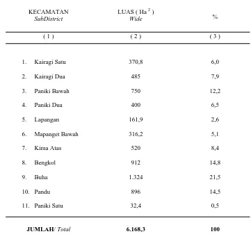
Tabel 1.3.7. LUAS KECAMATAN MAPANGET MENURUT KELURAHAN
TAHUN 2008
T a b l e Wide of Mapanget by Village
KECAMATAN SubDistrict
LUAS ( Ha 2 )
Wide %
( 1 ) ( 2 ) ( 3 )
1. Kairagi Satu
2. Kairagi Dua
3. Paniki Bawah
4. Paniki Dua
5. Lapangan
6. Mapanget Bawah
7. Kima Atas
8. Bengkol
9. Buha
10. Pandu
11. Paniki Satu
370,8
JUMLAH/ Total 6.168,3 100
Sumber : BPN Kota Manado
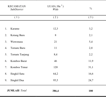
Tabel 1.3.8. LUAS KECAMATAN SINGKIL MENURUT KELURAHAN
TAHUN 2008
T a b l e Wide of Singkil by Village
KECAMATAN SubDistrict
LUAS ( Ha 2 )
Wide %
( 1 ) ( 2 ) ( 3 )
1. Karame
2. Ketang Baru
3. Wawonasa
4. Ternate Baru
5. Ternate Tanjung
6. Kombos Barat
7. Kombos Timur
8. Singkil Satu
9. Singkil Dua
12,3
8
21
11
8,4
46
120
64,2
95,5
3,2
2,1
5,4
2,8
2,2
11,9
31,1
16,6
24,7
JUMLAH/ Total 386,4 100
Sumber : BPN Kota Manado
Source : National Land Board Manado City
Tabel 1.3.9. LUAS KECAMATAN TUMINTING MENURUT KELURAHAN
TAHUN 2008
T a b l e Wide of Tuminting by Village
KECAMATAN SubDistrict
LUAS ( Ha 2 )
Wide %
( 1 ) ( 2 ) ( 3 )
1. Sindulang Satu
2. Kampung Islam
3. Sindulang Dua
4. Bitung Karang Ria
5. Maasing
6. Tuminting
7. Mahawu
8. Sumompo
9. Tumumpa Satu
10. Tumumpa Dua
22,6
30
11
37,8
30,5
43,8
74,4
113,6
19,9
19,9
5,6
7,4
2,7
9,4
7,6
10,9
18,4
28,2
4,9
4,9
JUMLAH/ Total 403,5 100
Sumber : BPN Kota Manado
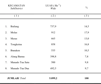
Tabel 1.3.10. LUAS KECAMATAN BUNAKEN MENURUT KELURAHAN
TAHUN 2008
T a b l e Wide of Bunaken by Village
KECAMATAN SubDistrict
LUAS ( Ha 2 )
Wide %
( 1 ) ( 2 ) ( 3 )
1. Bailang
2. Molas
3. Meras
4. Tongkeina
5. Bunaken
6. Alung Banua
7. Manado Tua Satu
8. Manado Tua Dua
737,9
912
665
858
535
398,8
500
492,5
14,5
17,9
13,0
16,8
10,5
7,8
9,8
9,7
JUMLAH/ Total 5.099,2 100
Sumber : BPN Kota Manado
Source : National Land Board Manado City
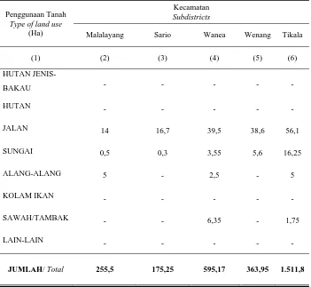
Tabel 1.3.11. LUAS PENGGUNAAN TANAH MENURUT JENIS PENGGUNAAN T a b l e TANAH PER KECAMATAN TAHUN 2008
Type of Land Use and its wide per subdistrict.
Penggunaan Tanah Type of Land Use
(Ha)
Kecamatan Subdistricts
Malalayang Sario Wanea Wenang Tikala
(1) (2) (3) (4) (5) (6)
PERUMAHAN 103,75 112,8 427,35 182,65 567,15
PERKUBURAN 1,5 0,5 3,5 3,5 11,25
LAPANGAN
OLAH-RAGA 1 4,55 1,45 0,45 3,4
JASA 7,1 24,3 55,55 49,6 43,25
USAHA 5,75 15,85 25,8 75,3 24,05
INDUSTRI 0,15 0,25 0,45 0,25 0,9
TKP 0,25 - 0,25 5 14,25
PKB 106,5 - 1,92 1,5 667,2
KTL 10 - 27 1,5 101,25
Tabel 1.3.11. LUAS PENGGUNAAN TANAH MENURUT JENIS PENGGUNAAN T a b l e TANAH PER KECAMATAN TAHUN 2008
Type of Land Use and its wide per subdistrict.
Lanjutan/ continuation
Penggunaan Tanah Type of land use
(Ha)
Kecamatan Subdistricts
Malalayang Sario Wanea Wenang Tikala
(1) (2) (3) (4) (5) (6)
HUTAN JENIS-
BAKAU - - -
HUTAN - - - - -
JALAN 14 16,7 39,5 38,6 56,1
SUNGAI 0,5 0,3 3,55 5,6 16,25
ALANG-ALANG 5 - 2,5 - 5
KOLAM IKAN - - - - -
SAWAH/TAMBAK - - 6,35 - 1,75
LAIN-LAIN - - - - -
JUMLAH/ Total 255,5 175,25 595,17 363,95 1.511,8
Bersambung / To be continued
Tabel 1.3.11. LUAS PENGGUNAAN TANAH MENURUT JENIS PENGGUNAAN T a b l e TANAH PER KECAMATAN TAHUN 2008
Type of Land Use and its wide per subdistrict.
Lanjutan/ continuation
Penggunaan Tanah Type of land use
(Ha)
Kecamatan Subdistricts
Mapanget Singkil Tuminting Bunaken
(1) (2) (3) (4) (5)
PERUMAHAN 312,3 218,6 240,1 171,65
PERKUBURAN 18,5 4,25 5,75 5,75
LAPANGAN OLAH-
RAGA 84,35 0,8 0,75 1,1
JASA 182,75 7,6 11,9 9
USAHA 21,9 5,55 6,65 38,25
INDUSTRI 1 0,4 0,95 -
TKP - 0,25 -
PKB 4.941,45 199 136 3.478,2
KTL 46,5 - - 324
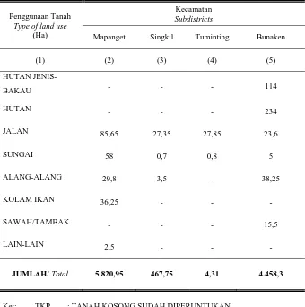
Tabel 1.3.11. LUAS PENGGUNAAN TANAH MENURUT JENIS PENGGUNAAN T a b l e TANAH PER KECAMATAN TAHUN 2008
Type of Land Use and its wide per subdistrict.
Lanjutan/ continuation
Penggunaan Tanah Type of land use
(Ha)
Kecamatan Subdistricts
Mapanget Singkil Tuminting Bunaken
(1) (2) (3) (4) (5)
HUTAN JENIS-
BAKAU - - - 114
HUTAN - - - 234
JALAN 85,65 27,35 27,85 23,6
SUNGAI 58 0,7 0,8 5
ALANG-ALANG 29,8 3,5 - 38,25
KOLAM IKAN 36,25 - - -
SAWAH/TAMBAK - - - 15,5
LAIN-LAIN 2,5 - - -
JUMLAH/ Total 5.820,95 467,75 4,31 4.458,3
Ket: TKP : TANAH KOSONG SUDAH DIPERUNTUKAN PKB : PERKEBUNAN
KTL : KEBUN, TEGALAN, LADANG
Sumber : BPN Kota Manado
Source : National Land Board Manado City
Tabel 1.4.1 NAMA–NAMA GUNUNG DAN TINGGINYA T a b l e Name of Mounts and their heights
NAMA GUNUNG Name of Mount
KECAMATAN Subdistrict
TINGGI ( m ) Height
( 1 ) ( 2 ) ( 3 )
Manado Tua
Tumpa
Bunaken
Bunaken
655
610
Sumber : BPN Kota Manado
Tabel 1.4.2 PULAU-PULAU YANG MASUK DALAM WILAYAH ADMINISTRASI T a b l e KOTA MANADO
Islands in Manado’s administrative teritory
NAMA PULAU Name of Island
LUAS Wide
PANJANG GARIS PANTAI Line Shore (M)
WILAYAH
KELURAHAN/KECAMATAN Rural/District Location
( 1 ) ( 2 ) ( 3 )
Manado Tua
Bunaken
Siladen
1.056,02
811,21
27,95
12.280
17.570
2.240
Manado Tua Satu dan Manado
Tua Dua Kec. Bunaken
Bunaken dan Alung Banua
Kec. Bunaken
Bunaken Kec. Bunaken
Sumber : BPN Kota Manado
Source: National Land Board Manado City
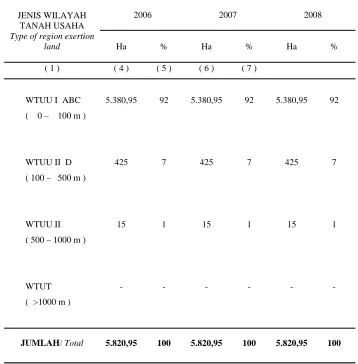
Tabel 1.5.1. LUAS WILAYAH TANAH USAHA MENURUT JENISNYA T a b l e DI KECAMATAN MALALAYANG TAHUN 2006 - 2008
Wide of region exertion land by Variety in Malalayang in 2006 - 2008
JENIS WILAYAH TANAH USAHA Type of region exertion
land
2006 2007 2008
Ha % Ha % Ha %
( 1 ) ( 4 ) ( 5 ) ( 6 ) ( 7 )
WTUU I ABC
( 0 – 100 m )
WTUU II D
( 100 – 500 m )
WTUU II
( 500 – 1000 m )
WTUT
( >1000 m )
5.380,95
425
15
-
92
7
1
-
5.380,95
425
15
-
92
7
1
-
5.380,95
425
15
-
92
7
1
-
JUMLAH/ Total 5.820,95 100 5.820,95 100 5.820,95 100
Sumber : BPN Kota Manado
Tabel 1.5.2. LUAS WILAYAH TANAH USAHA MENURUT JENISNYA T a b l e DI KECAMATAN SARIO TAHUN 2006 - 2008
Wide of region exertion land by Variety in Sario in 2006 - 2008
JENIS WILAYAH TANAH USAHA Type of region exertion
land
2006 2007 2008
Ha % Ha % Ha %
( 1 ) ( 2 ) ( 3 ) ( 4 ) ( 5 ) ( 6 ) ( 7 )
WTUU I ABC ( 0 – 100 m )
WTUU II D ( 100 – 500 m )
WTUU II ( 500 – 1000 m )
WTUT ( >1000 m )
193,25
-
-
-
100 193,25
-
-
-
100 193,25
-
-
-
100
JUMLAH/ Total 193,25 100 193,25 100 193,25 100
Sumber : BPN Kota Manado
Source : National Land Board Manado City
Tabel 1.5.3. LUAS WILAYAH TANAH USAHA MENURUT JENISNYA T a b l e DI KECAMATAN WANEA TAHUN 2006 - 2008
Wide of region exertion land by Variety in Wanea in 2006 - 2008
JENIS WILAYAH TANAH USAHA Type of region
exertion land
2006 2007 2008
Ha % Ha % Ha %
( 1 ) ( 2 ) ( 3 ) ( 4 ) ( 5 ) ( 6 ) ( 7 )
WTUU I ABC ( 0 – 100 m )
WTUU II D ( 100 – 500 m )
WTUU II ( 500 – 1000 m )
WTUT ( >1000 m )
765,25
20
-
-
97
3
765,25
20
-
-
97
3
765,25
20
-
-
97
3
JUMLAH/ Total 785,25 100 785,25 100 785,25 100
Sumber : BPN Kota Manado
Tabel 1.5.4. LUAS WILAYAH TANAH USAHA MENURUT JENISNYA T a b l e DI KECAMATAN WENANG TAHUN 2006 - 2008
Wide of region exertion land by Variety in Wenang in 2006 - 2008
JENIS WILAYAH TANAH USAHA Type of region exertion
land
2006 2007 2008
Ha % Ha % Ha %
( 1 ) ( 2 ) ( 3 ) ( 4 ) ( 5 ) ( 6 ) ( 7 )
WTUU I ABC ( 0 – 100 m )
WTUU II D ( 100 – 500 m )
WTUU II ( 500 – 1000 m )
WTUT ( >1000 m )
398,95
-
-
-
100 398,95
-
-
-
100 398,95
-
-
-
100
JUMLAH/ Total 398,95 100 398,95 100 398,95 100
Sumber : BPN Kota Manado
Source : National Land Board Manado City
Tabel 1.5.5. LUAS WILAYAH TANAH USAHA MENURUT JENISNYA T a b l e DI KECAMATAN TIKALA TAHUN 2006 - 2008
Wide of region exertion land by Variety in Tikala in 2006 - 2008
JENIS WILAYAH TANAH USAHA Type of region exertion
land
2006 2007 2008
Ha % Ha % Ha %
( 1 ) ( 2 ) ( 3 ) ( 4 ) ( 5 ) ( 6 ) ( 7 )
WTUU I ABC ( 0 – 100 m )
WTUU II D ( 100 – 500 m )
WTUU II ( 500 – 1000 m )
WTUT ( >1000 m )
1.511,80
-
-
-
100 1.511,80
-
-
-
100 1.511,80
-
-
-
100
JUMLAH/ Total 1.511,80 100 1.511,80 100 1.511,80 100
Sumber : BPN Kota Manado
Tabel 1.5.6. LUAS WILAYAH TANAH USAHA MENURUT JENISNYA T a b l e DI KECAMATAN TUMINTING TAHUN 2006 - 2008
Wide of region exertion land by Variety in Tuminting in 2006 - 2008
JENIS WILAYAH TANAH USAHA Type of region exertion
land
2006 2007 2008
Ha % Ha % Ha %
( 1 ) ( 2 ) ( 3 ) ( 4 ) ( 5 ) ( 6 ) ( 7 )
WTUU I ABC ( 0 – 100 m )
WTUU II D ( 100 – 500 m )
WTUU II ( 500 – 1000 m )
WTUT ( >1000 m )
431
-
-
-
100 431
-
-
-
100 431
-
-
-
100
JUMLAH/ Total 431 100 431 100 431 100
Sumber : BPN Kota Manado
Source : National Land Board Manado City
Tabel 1.5.7. LUAS WILAYAH TANAH USAHA MENURUT JENISNYA T a b l e DI KECAMATAN BUNAKEN TAHUN 2006 - 2008
Wide of region exertion land by Variety in Bunaken in 2006 - 2008
JENIS WILAYAH TANAH USAHA Type of region exertion
land
2006 2007 2008
Ha % Ha % Ha %
( 1 ) ( 2 ) ( 3 ) ( 4 ) ( 5 ) ( 6 ) ( 7 )
WTUU I ABC ( 0 – 100 m )
WTUU II D ( 100 – 500 m )
WTUU II ( 500 – 1000 m )
WTUT ( >1000 m )
3.058,30
1.300
100
-
69
29
2
3.058,30
1.300
100
-
69
29
2
3.058,30
1.300
100
-
69
29
2
JUMLAH/ Total 4.458,30 100 4.458,30 100 4.458,30 100
Sumber : BPN Kota Manado
Tabel 1.6.1. SUHU UDARA MAKSIMUM DAN MINIMUM TAHUN 2006 - 2008
Pebruari/ February
Maret/ March
April/ April
M e i / M a y
J u n i / J u n e
J u l i / J u l y
Agustus/ August
September/Sept.
Oktober/ October
Nopember/November
Desember/ Dec.
31,8
Sumber : Stasiun Meteorologi Manado Source : Meteorology Station of Manado
Tabel 1.6.2 KEADAAN SUHU UDARA RATA-RATA PER BULAN T a b l e TAHUN 2004 - 2008
Mean Temperature Circumstance by month, 2004 – 2008
B U L A N
M o n t h 2004 2005 2006 2007 2008
( 1 ) ( 2 ) ( 3 ) ( 4 ) ( 5 ) ( 6 )
Januari/ January
Pebruari/ February
Maret/ March
April/ April
M e i / M a y
J u n i / J u n e
J u l i / J u l y
Agustus/ August
September/ September
Oktober/ October
Nopember/ November
Desember/ December
25,7
Tabel 1.6.3 KELEMBABAN NISBI MENURUT BULAN PADA PENGUKURAN T a b l e STASIUN GEOFISIKA MANADO TAHUN 2004 – 2008
(%)
Relative Dampness By Month at the measurement of Manado City’s Meteorology Station in 2004 – 2008
B U L A N
M o n t h 2004 2005 2006 2007 2008
( 1 ) ( 2 ) ( 3 ) ( 4 ) ( 5 ) ( 6 )
Januari/ January
Pebruari/ February
Maret/ March
April/ April
M e i / M a y
J u n i / J u n e
J u l I / J u l y
Agustus/ August
September/ September
Oktober/ October
Nopember/ November
Desember/ December
86
Sumber : Stasiun Meteorologi Manado Source : Meteorology Station of Manado
Tabel 1.6.4 KEADAAN TEKANAN UDARA OO.OOZ RATA-RATA PADA
T a b l e PENGUKURAN STASIUN GEOFISIKA MANADO TAHUN 2005 - 2008 Mean OO.O0Z Atmospheric Pressure Circumstance at Manado City’s Meteorology station in 2005 – 2008
B U L A N
M o n t h 2005 2006 2007 2008
( 1 ) ( 2 ) ( 3 ) ( 4 ) ( 5 )
Januari/ January
Pebruari/ February
Maret/ March
April/ April
M e i / M a y
J u n i / J u n e
J u l i / J u l y
Agustus/ August
September/ September
Oktober/ October
Nopember/ November
Desember/ December
1.011,8
Tabel 1.6.5 PENYINARAN MATAHARI ,CURAH HUJAN DAN T a b l e HARI HUJAN TAHUN 2007 – 2008 BERDASARKAN PENGAMATAN DARI STASIUN GEOFISIKA WINANGUN
Sun Irradiating, Rainfall and Number of Rainy Days in 2007 – 2008 based on observation at Meteorology Station Mapanget
B U L A N
Januari/ January
Pebruari/ February
Maret/ March
April/ April
M e i / M a y
J u n i / J u n e
J u l i / J u l y
Agustus/ August
September/ September
Oktober/ October
Nopember/ November
Desember/ December
33
Sumber : Stasiun Meteorologi Manado Source : Meteorology Station of Manado
Tabel 1.6.6
KECEPATAN ANGIN MAKSIMUM DAN RATA-RATA
T a b l e MENURUT BULAN TAHUN 2008 Maximum and Mean Wind Speed by Month
B U L A N M o n t h
Tahun 2008
Kecepatan
Arah Angin pada kec
Maks/
( 1 ) ( 2 ) ( 3 ) ( 4 ) ( 5 )
Januari/ January
Pebruari/ February
Maret/ March
April/ April
M e i / M a y
J u n i / J u n e
J u l i / J u l y
Agustus/ August
September/ September
Oktober/ October
Nopember/ November
Desember/ December
2,9
Tabel 1.6.7 GEMPA TERCATAT DI STASIUN GEOFISIKA MANADO T a b l e MENURUT BULAN
Earthquake noted at Geophysics Station Manado by Month
B U L A N M o n t h
2006 2007 2008
Lokal
Maret/ March
April/ April
M e i / M a y
J u n i / J u n e
J u l i / J u l y
Agustus/ August
September/
Sept.
Oktober/
October
Nopember/ Nov.
Desember/ Dec. 66