IJG Vol. 47, No.2, December 2015 (187 - 193) © 2015 Faculty of Geography UGM and he Indonesian Geographers Association
Landform Control On Settlement Distribution Pattern in Progo
Delta, Indonesia
Suprapto Dibyosaputro
Received: 30 01 2015 / Accepted: 01 05 2015 / Published online: 15 02 2016 © 2015 Faculty of Geography UGM and he Indonesian Geographers Association
Abstract Landform is part of the Earth ‘s surface whose characteristics afect resources and geomorphological hazard, and therefore, afect humans in determining their choices in building settlements. his research aims to : ( 1 ) analyze landforms control on settlement distribution pattern in abandoned Progo Delta, and ( 2 ) analyze the factors that inlu-ence humas in choicing their residental locations. Landform control on the settlement distribution was analyzed from produced geomorphological and settlement maps and overlay them. he inluence factors were analyzed from the re-sults of in-depth interviews conducted in each village in the study area. he rere-sults show that the settlement in the study area is distributed in a dispersed pattern, following the presence of abandoned delta’s natural levees. he inluencing factors include lat topography that implies a good accessibility, soil fertility that deines land capability in sustaining their life, water resource availability, and security from disasters especially loods.
Abstrak Bentuklahan merupakan bagian permukaan Bumi yang memiliki karakteristik tertentu dan mempengaruhi
sum-berdaya dan bahaya geomorfologi. Kondisi tersebut akan mempengaruhi manusia dalam menentukan lokasi permukiman. Penelitian ini bertujuan untuk: (1) menganalisis kontrol bentuklahan terhadap pola persebaran permukiman di Delta Progo tak-aktif, dan (2) menganalisis faktor-faktor yang memepengaruhi penduduk dalam pemilihan lokasi permukiman. Analisis kontrol bentuklahan terhadap persebaran permukiman dilakukan dengan pembuatan peta-peta geomorfologi dan permukiman dan kemudian keduanya ditumpangsusunkan. Analisis faktor-faktor yang mempengaruhi pemilihan lokasi permukiman dilakukan dengan wawancara mendalam pada setiap dusun di lokasi kajian. Hasil penelitian menun-jukkan bahwa permukiman di Delta Progo tak-aktif memiliki pola menyebar mengikuti keberadaan bekas tanggul alam delta tersebut. Diketahui pula bahwa faktor-faktor yang mempengaruhi pemilihan lokasi permukiman penduduk adalah topograi datar yang menjadikan akses yang mudah, kesuburan tanahtinggi yang menentukan kemampuan lahan dalam menopang kehidupan masyarakat, ketersediaan sumberdaya air banyak dan keamanan lokasi permukiman dari bencana khususnya banjir.
Keywords: Settlement distribution pattern, Landform control, Abandoned delta, Progo River
Kata kunci: Pola sebaran permukiman, Kontrol bentuklahan, Delta tak-aktif, Sungai Progo
Settlement is a place used by a group of people in conducting their social and economic activities as substantial parts of their life sustainability (Yunus, 2005, 2007). he existence of a settlement in an area represents a harmonious interaction between human and environment. Such interaction is relected in the form of diferent settlement shapes and patterns between regions.
High population growth leads to an increasing demand on residential land (Giyarsih, 2010; Amar, 2012). However, not every land is suitable for settlement as well as the wide variety of social and economic activities conducted by its residents (Gwalema, 2011). Generally, humans, either as individuals or as groups, tend to choose a settlement whose location is deemed
Suprapto Dibyosaputro
Department of Environmental Geography, Faculty of Geography, Universitas Gadjah Mada
Email: [email protected]
suitable for their life sustainability (Muta’ali, 2011). herefore, only a certain land has a high suitability for settlements located in landforms of various origins. Regarding the aspects entailed by a settlement, i.e. engineering aspects in house construction as well as social and economic aspects in achieving a decent life (Giyarsih and Alfana, 2013), considerations in selecting a location include a good accessibility (Oluwole and Daful, 2014). adequate water supply, security from natural disasters and wild animals, as well as a supportive surrounding area that is able to sustain the life of the residents (Dibyosaputro, 1987).
he spatial distribution of a landform, which has speciic land characteristics required in developing a settlement, is diferent between forms of origin (Verstappen, 2014), as implicitly represented in the third principal concept of geomorphology which states that:
”Geomorphic processes leave their distinctive imprint upon landforms and each geomorphic process develops its
own characteristic assemblage of landforms” (hornbury, 1958).
herefore, each of these landforms owns diferent potentials depending on their morphology/topography, climate, rock, and formation process (Cooke and Dornkamp, 1974; Panizza, 1996).
Landform is the main study object in geomorphology, as presented in its deinition, which is a science that describes landforms (genetically) and processes that lead to their formations as well as the relationships between landforms and processes in a spatial arrangement (van Zuidam and Cancelado, 1979; Huggett, 2011). Due to the extremely complex landscapes on the Earth’s surface, the spatial distribution of various composing landforms is irstly deined by classifying landscapes into simpler units, i.e. landform units based on their similarities in nature and character (Gorum et al., 2008; Verstappen, 2014). hese similarities include:
a. the conigurations of the Earth’s surface including topographic impressions, e.g., terrain and topography (undulating, rolling, hilly, mountainous);
b. topographic expressions, emphasizing on the composing parameters of landforms, e.g., the degree, shape, and length of slopes, local elevation diference (local relief), and the shape of valleys;
c. geological structures and types of rock/ material; and
d. geomorphological processes that lead into the formation of landforms.
Based on the previously described nature and character similarity and the principle to landforms genesis (forms of origin), Verstappen and Zuidam (1975) as well as van Zuidam and Cancelado (1979) distinguished landforms into two major classiications, namely a classiication based on endogenous forces and geology/geological structures and a classiication based on geomorphological processes originated from exogenous forces.
Settlement growth that occurs without development planning plausibly results in a suboptimal land utilization in supporting the activities of each resident (Kurniawan and Krol, 2014). his condition would likely occur because the development planning doesn’t consider both potential and land suitability for settlement in related landforms. Consequently, several problems may eventually occur, for instance, many disaster-afected settlements, lack of resources (e.g. clean water) in some parts of the settlement, and other environmental damages.
In addition to potential and land suitability for settlement, a residential pattern arrangement within a settlement needs to pay attention to the spatial distribution of landforms of certain origins. Initially, a residential location is naturally selected from locations with good accessibility which follows the pattern of the landform where a residence is built. In the past, houses of a settlement were built individually according
to the taste of each resident or a group or residents. Furthermore, the houses were built, either individually or communally, in locations that were not only itting the residents’ tastes but also accessible, surrounded by areas with good carrying capacities in supporting their life sustainability, and also owning easiness in obtaining water and security from natural hazards and wild animals. Naturally, this taste-based residential site selection indirectly refers to certain aspects which encompass geographical aspects, viz. physical, social, economic, and cultural aspects.
A settlement distribution pattern is a relection of the adaptation level of human beings to their environment (Bintarto, 1977), which implies that in actuality they own alternatives in selecting a speciic location for settling and building houses. Generally, these alternatives should follow both patterns and elements of highly potential landforms in meeting the requirements for residential sites because each landform entails hazards and geomorphological resources that inluence the life sustainability of human beings (Gares et al., 1994; Mey et al., 2009; Alcantara-Ayala and Goudie, 2010; Crozier, 2010). Moreover, the characteristics of each landform certainly afect the accessibility of a location due to the entailed morphological features (Panizza, 1986; Marwasta and Priyono, 2007). Based on the previous description, this research is composed with aims to:
a. analyze the landform control on the settlement distribution pattern in the abandoned delta of Progo River; and
b. analyze the factors that inluence humans in choosing their residential locations.
2. he Methods
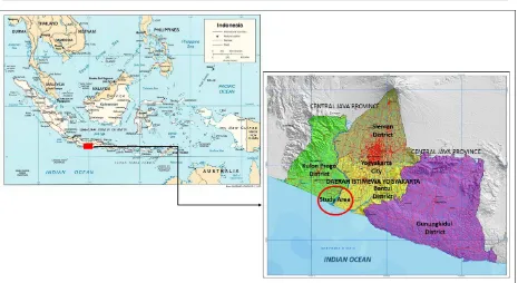
he study area is located in a landform, the abandoned delta of Progo River. Administratively, it lies on two regencies, which are Bantul and Kulon Progo Regency, Special Region of Yogyakarta, Indonesia. he location of the study area is shown in Figure 1.
his location was selected because it is a landform that developed in the past, therefore, it is expected to display a good control on the settlement pattern, which has occurred since the past. In addition, this location has various landforms with distinctive characteristics, therefore, it especially represents diferent controls on the settlement distribution pattern in each landform.
he tools and materials used in this study include: 1. he Geological Map of Yogyakarta, scale 1:100,000, published by the Geology Agency, Ministry of Energy and Mineral Resources of Indonesia;
2. he Topographic Map (Rupa Bumi Indonesia – RBI), scale 1:25,000, published by Geospatial Information Agency of Indonesia;
3. High-resolution satellite images obtained from Google Earth;
Landform control on settlement distribution was analyzed using three steps, i.e. geomorphological mapping in the abandoned delta of Progo River, settlement distribution mapping, and analysis on the overlaid maps produced by the previous steps. Geomorphological mapping was conducted by digitizing landform units on high-resolution satellite images and by considering the analysis results on topographic map, geological map, and ield survey. Meanwhile, the settlement distribution mapping was conducted by digitizing high-resolution satellite image and ield survey. he result of overlaid geomorphological map and settlement distribution map shows the spatial pattern of the settlement distribution and its relation to landform.
he inluencing factors in residential site selection were analyzed from the results of in-depth interviews to the public igures of each hamlet in the study area, which include the heads of hamlets and the local elders.
3. Result and Discussion
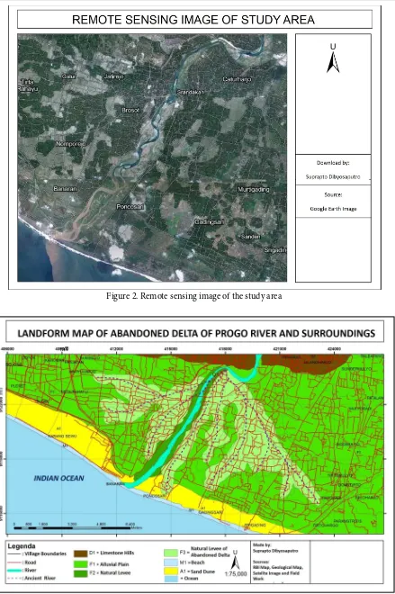
he luvio-marine landform studied in this research is an abandoned delta. he condition of the study area is presented in a Google Earth satellite image in Figure 2 and the landform map of the delta is in Figure 3. his abandoned delta has not experienced any marine-induced geomorphological development, as presented by the farther located shorelines due to accretion at the mouth of Progo River.
Delta is one of many landforms resulted from sediment deposition at the mouth of the river, in which a pile of sediments cause irregular progradation on shorelines (Coleman, 1968). Delta formation is strongly
related to luvial and marine processes (Goudie, 2004). However, it is generally related to three major forces, i.e. forces originated from streams, waves, and sea tides. A river deposits its load onto a land whenever its transport ability weakens, viz. stream competency and stream capacity drop. his deposition occurs at the brakes of slope, inner meander bends, intersections between two rivers, and river gradient changes. Nevertheless, deposition also occurs when a river lows into a lake or sea and, then, forms a delta. he requirements of a delta formation are as follows:
a. river lowing into a lake or sea; b. shallow sea;
c. low sea waves and currents;
d. no tectonic movements that cause seabed or lake (at the mouth of the river) down-liting;
e. strong tidal currents; and
f. abundant rock materials deposited on the sea or lake from time to time.
Figure 2. Remote sensing image of the study area
is bordered by two limestone hills of Sentolo Formation that are administratively located between Sidorejo Village, western Kulon Progo Regency and Triharjo Village, eastern Kulon Progo Regency.
Considering the requirements of delta formation, it is known that the developing alluvial plains in the study area were previously a shallow sea. he delta formed at the Progo River in the past shows that during that time Progo River transported abundant sediments and that the sea tide closed to the river mouth was not strong enough; therefore, a bird foot delta was formed. he upper part of this bird foot delta were on a narrow valley, which was also right at the topographical change from Sentolo Hills to a shallow sea whose shoreline had been experiencing southward accretion and creating lowlands in the form of alluvial plains with a lat slope. he small river gradient created low stream capacity and stream competency and, therefore, transported smaller sediment volume and grain size. And inally, in the event of looding, the transported sediments were overlowed and deposited on both sides of the river. his event, then, formed natural levees with a scatter pattern (dendritic divergent pattern) like a bird foot.
During the active delta formation, lowlands were formed by alluvium deposition between the old natural levees of delta in the forms of back swamps and alluvial plains. But, due to an inactive (dormant) delta formation,
sedimentation within a river body and onto inteluvial lands continued. his sedimentation occurred because the presence of sediment materials from soil erosion at river embankments or hills in the north. herefore, old rivers along with their back swamps and alluvial plains became shallower than before and even had the same elevation as natural levees.
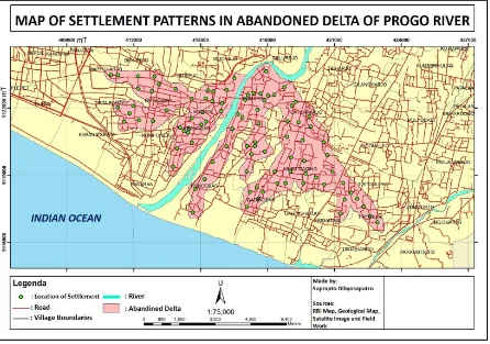
Lowlands located between the river channels are generally in the form of alluvial plains, composed of alluvial soils that have a higher moisture than the soils at the upstream river banks. Alluvial plains are always moist and characterized by shallow groundwater and dense vegetation (Verstappen, 2014). Most areas of lowlands are used for agricultural land, while the ones of the abandoned delta’s natural levees are for settlement and dry cultivated area. he map shows a clear shape of the bird foot delta whose river levees are used for settlement and its yard, while its alluvial plains are used for wet cultivated area (rice).
Gulurejo Village, where Progo River emerges from Sentolo Hills, is the location of the delta’s early development in the downstream end of Progo River. It was also the old mouth of Progo River in the past. Being situated between two villages, i.e. Sidorejo Village, Kulon Progo Regency on the west side and Triharjo Village, Bantul Regency on the east side, Progo River emptied into a shallow sea and, therefore, formed a
delta. Generally, the scars of today’s dormant levees are chosen as residential locations. Figure 4 represents the plots of residential locations in this dormant bird foot delta. his igure also shows that the settlement pattern is clustered on the natural levees of the abandoned Progo Delta. he distribution of residences in the settlements located at the Progo Delta shows a scatter (divergent) pattern following the pattern of both the river and its levee.
Based on the results of in-depth interviews to the residents at the abandoned delta of Progo River, there are at least four main reasons of residential site location. he four factors are as follows.
a. A lat topography that supports a good accessibility, which is signiicantly related to the fulilling of the residents’ needs on goods and services that must be brought from the outside.
b. A surrounding area that sustains the residents’ life. his surrounding area is fertile alluvial plains, composed of fertile alluvial soils, which are suitable for rice ields. his advantage is considered as an insurance to the residents for a better life.
c. A signiicant amount of water supply that fulills both domestic and irrigation needs. he residents of the study area are generally farmers whose lands are utilized for wet agricultural practices (rice).
d. A secure area from threats, such as natural hazards esp. loods, due to its higher location than the active alluvial plains and loodplains of Progo River.
4. Conclusion
Based on the analysis conducted in this research, it can be concluded that the settlement pattern at the abandoned delta of Progo River is distributed following the pattern formed by its natural levees, and the inluencing factors in residential site selection include a lat topography that creates a good accessibility, a fertile area that sustains the residents’ life, an abundant water supply, as well as a secure area from natural hazards especially loods.
Acknowledment
his study is part of researches funded by the Research Grants for the Lecturers of the Faculty of Geography, Universitas Gadjah Mada in 2013. Author would like to thank the faculty, who was willing to fund this study, and also the research assistants of the Department of Environmental Geography, Faculty of Geography, Universitas Gadjah Mada who have participated in ield data acquirement for this study.
References
Alcantara-Ayala, I. and Goudie, A.S. (2010). Geomorphological Hazards and Disaster Prevention. Cambridge: Cambridge University Press.
Amar, A., (2012). Land Use Model for Building Based on Carrying Capacity of City Land (Case Study:
Palu City). Indonesian Journal of Geography, 44(2), 183-194.
Bintarto, R. (1977). Geograi Sosial. Yogyakarta: U.P. Spring.
Coleman, J.M. (1968). Deltaic evolution. In he
Encyclopedia of Geomorphology Vol. III,
R.Fairbridge.
Cooke, R.U. and Doornkamp, J.C. (1974). Geomorphology in Environmental Management. London: Clarendom Press.
Crozier, M.J. (2010). Landslide Geomorphology: An Argument for Recognition, with Examples from New Zealand. Geomorphology. 120 (1–2), 3–15. Dibyosaputro, S. (1987). Geomorphology and
Archaeological Sites of Bujang Valley Area, Malaysia. he Indonesian Journal of Geography, 17(54), 23-35.
Gares, P.A., Sherman, D.J. and Nordstrom, K.F. (1994). Geomorphology and Natural Hazards. Geomorphology, 10, 1– 18.
Giyarsih, S.R. (2010). Urban Sprawl of the City of Yogyakarta, Special Reference to the Stage of Spatial Transformation. Indonesian Journal of Geography, 42(1), 47-58.
Giyarsih, S.R. and Alfana, M.A. (2013). he Role of Urban Area as the Determinant Factor of Population Growth. Indonesian Journal of Geography, 45(1), 38-47.
Gorum, T., Gonencgil B., Gokceoglu, C., and Nefeslioglu, H.A. (2008). Implementation of Reconstructed Geomorphologic Units in Landslide Susceptibility Mapping: he Melen Gorge (NW Turkey). Natural Hazards, 46, 323–351.
Goudie A.S. (2004). Encyclopedia of Geomorphology. New York: Routledge Taylor and Francis Group. Gwalema, S.R. (2011). Impacts of Urban Development
Pressure on Coastal Local communities in Tanzania. Indonesian Journal of Geography, 43(2), 123-141.
Huggett, R.J. (2011). Fundamentals of Geomorphology, hird Edition. New York: Routledge, Taylor and Francis Group.
Kurniawan, A. and Krol, B.G.C.M. (2014). Spatio Temporal Analysis of Land Use Change for Supporting Landslide Exposure Assessment. Indonesian Journal of Geography, 46(2), 104-124. Marwasta, D. and Priyono, K.D. (2007). Analisis
Karakteristik Permukiman Desa-Desa Pesisir di Kabupaten Kulonprogo, Yogyakarta. Forum Geograi, 21 (1), 57-68.
Mey, E.T.W., Sudibyakto, and Kingma, N.C. (2009). Land Use Planning for Settlements Area in Consideration of Flood and Landslide Hazards in Bagelen, Purworejo, Indonesia. Indonesian Journal of Geography, 41(1), 71-91.
Panizza, M. (1986). Environmental Geomorphology. Amsterdam: Elsevier.
hornbury, W.D. (1958). Principles of Geomorphology. New York: John Wiley and Sons.
Verstappen, H.h. and van Zuidam, R.A. (1975). ITC
System of Geomorphological Survey. Enchede, the
Netherlands: ITC Texbook of Photo Interpretation, Vol. II.
Verstappen, H. h. (2014). Geomorfologi Terapan: Survei Geomorfologikal untuk Pengembangan
Lingkungan. Yogyakarta: Ombak.
Van Zuidam, R.A. and Cancelado, F.I. (1979). Terrain Analysis and Classiication Using Aerial Photographs, ITC Textbook of Photo-Interpretation,
Vol. VII, International Institute for Aerial
Survey and Earth Science (ITC), Enschede, the Netherlands.
Yunus, H.S. 2005. Manajemen Kota Perspektif Spasial. Yogyakarta: Pustaka Pelajar.
Yunus, H.S. 2007. Subject Matter dan Metode Penelitian
Geograi Permukiman Kota. Yogyakarta: Fakultas