A METHOD FOR THE EXTRACTION OF LONG-TERM DEFORMATION
CHARACTERISTICS OF LONG-SPAN HIGH-SPEED RAILWAY BRIDGES USING
HIGH-RESOLUTION SAR IMAGES
H. G. Jia a, b, c, d*, L.Y. Liua
a Faculty of Geosciences and Environmental Engineering, Southwest Jiaotong University, Chengdu, Sichuan, China bState Key Laboratory of Geodesy and Earth’s Dynamics, Wuhan, Hubei, China
c
Collaborative Innovation Center for Rail Transport Safety, Ministry of Education of the People’s Republic of China, Southwest
Jiaotong University, Chengdu, Sichuan, China d
State-Province Joint Engineering Laboratory of Spatial Information Technology for High-Speed Railway Safety, Southwest
Jiaotong University, Chengdu, Sichuan, China
Commission VII, WG VII/2
KEY WORDS: InSAR, High Resolution, Deformation Characteristic, Long-term, Long-span Bridge
ABSTRACT:
Natural causes and high-speed train load will result in the structural deformation of long-span bridges, which greatly influence the
safety operation of high-speed railway. Hence it is necessary to conduct the deformation monitoring and regular status assessment for
long-span bridges. However for some traditional surveying technique, e.g. control-point-based surveying techniques, a lot of human
and material resources are needed to perform the long-term monitoring for the whole bridge. In this study we detected the long-term
bridge deformation time-series by persistent scatterer interferometric synthetic aperture radar (PSInSAR) technique using the
high-resolution SAR images and external digital elevation model. A test area in Nanjing city in China is chosen and TerraSAR-X
images and Tandem-X for this area have been used. There is the Dashengguan bridge in high speed railway in this area as study
object to evaluate this method. Experiment results indicate that the proposed method can effectively extract the long-term
deformation of long-span high-speed railway bridge with higher accuracy.
* Corresponding author
1. INTRODUCTION
Long-span bridges have complicated structure so that the safe
operation of the bridges is sensitive to small deformations.
Hence the deformation monitoring of long-span bridges needs
high accuracy. Typical methods for the deformation monitoring
are traditional engineering surveying techniques, methods using
physical sensors and GPS surveying techniques. By these
techniques, the absolute deformation information in local parts
of bridges can be obtained. However, these techniques need
amount of manpower and material resources, and are performed
by some control points so that it is difficult to achieve the
deformation information for the whole bridge. Recently,
Interferometric Synthetic Aperture (InSAR) technique has been
often applied (Ferretti et al. 2001, Berardino et al. 2002, Lanari
et al. 2004, Hooper et al. 2007, Liu et al. 2009, Masahiro et al.
2010, Zhang et al. 2011, Ferretti et al. 2011, Wang et al. 2012)
to solving these issues, because it can detect the deformation
information for the whole target areas, and has high
measurement accuracy and automatic degree, and few The International Archives of the Photogrammetry, Remote Sensing and Spatial Information Sciences, Volume XLI-B7, 2016
XXIII ISPRS Congress, 12–19 July 2016, Prague, Czech Republic
This contribution has been peer-reviewed.
manpower, and so on. Currently, some SAR sensors with high
spatial resolutions has been used, e.g. TerraSAR-X,
COSMO-SkyMed, Sentinel-1 A and B, which can detect the
deformation for very small object, e.g. a building. WorldDEM
generated by TanDEM-X has the 10m absolute vertical
accuracy and 2m relative vertical accuracy. This article aims to
detect the deformation in long time series for the Dashengguan
bridge in Nanjing by the integration of TanDEM and
TerraSAR-X images.
2. DEFORMATION MONITORING WITH PSINSAR
2.1 Study Area and Data Source
Nanjing, the capital city of Jiangsu province, is in east China.
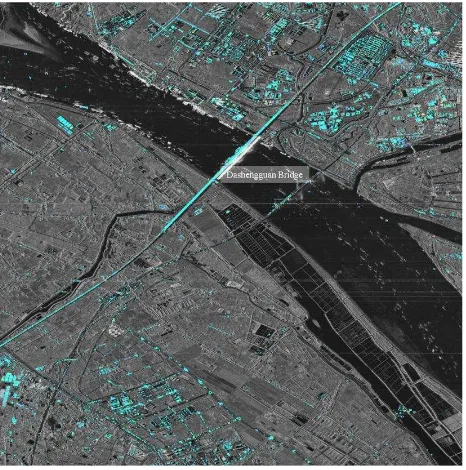
The Dashengguan Bridge (See Figure 1) is located in Nanjing
Jianye District and in this bridge, there are six railway lines, i.e.
Peking to Shanghai, Shanghai to Chengdu, and Nanjing
underground. This length of this bridge is 9.273 km and the load
of this bridge is the highest in the world. Due to the great length,
high load, high running speed, and complex structure, it is
necessary to conduct a deformation monitoring in long time
series for the safe operation of this bridge.
Figure 1. Dashengguan Bridge in Nanjing
In this study, 14 TerraSAR images acquired during descending
pass between 31 May 2013 and 2 January 2016 were utilized.
The time series of deformation at 7 PSs are derived (See Table
1).
Table 1. Acquisition Time of 14 TSX images
2.2 Experimental results and discussion
A. Distribution of TCPs Identified for the Study Area
In this study, 21 interferometric pairs formed by 14 TSX images
are used to detect persistent scatterers (PSs). According to the
correlation coefficients of all pixels on images, a threshold is
given. If the correlation coefficient of a pixel is more than the
threshold, it is selected as a PS point. By this method, 238552
PSs are selected from the study area and mainly the fence, hard
shoulder and street lamp on the bridges.
Figure 2. PS point distribution in study area.
B. Subsidence Signature Derived from PS Solution
The resultant subsidence rates at all the valid PSs are shown in
Figure 3. The subsidence rates within the entire study area range
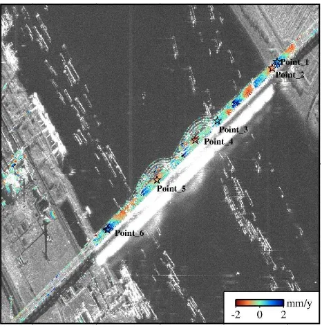
between -40 and 30 mm/yr. In order to further analyze the finer
deformation, six PS points are selected to achieve the time
series of the deformation (See Figure 4).
The International Archives of the Photogrammetry, Remote Sensing and Spatial Information Sciences, Volume XLI-B7, 2016 XXIII ISPRS Congress, 12–19 July 2016, Prague, Czech Republic
This contribution has been peer-reviewed.
Figure 3. Deformation rates of the study area
Figure 4. Deformation rates of bridge
As illustrated in Figure 4, the deformation rates change from
-2mm to 2mm. The deformation rates of six PS points are
shown in Figure 5. From the Figure 5, it is noted that the
deformation periodically changes for different seasons. The
reason may be the temperature influence in different seasons.
Figure 5. Deformation time series of 6 PSs
3. CONCLUSION
This article used PSI technique to detect the deformation
information from 31 May 2013 to 2 January 2016 for
Dashengguan Bridge in Nanjing. During the period of time, the
deformation of the bridge is from -2mm to 2mm and has a
significant seasonal change, which may arise from the
temperature factor. In future work, more TSX images are used
to improve the reliability and accuracy of the finer deformation
monitoring. In addition, the measurement data collected from
leveling and GPS surveying will be used to evaluate the
deformation results.
ACKNOWLEDGEMENTS
This project is supported by State Key Laboratory of Geodesy and Earth’s Dynamics (SKLGED2015-5-1-E), the Fundamental Research Funds for the Central Universities (2682015CX015),
the National Natural Science Foundation of China (41474003),
Program for Changjiang Scholars and Innovative Research
Team in University (IRT13092).
REFERENCES
Berardino, P., Fornaro, G., Lanari, R., Sansosti, E., 2002. A new
algorithm for surface deformation monitoring based on small
baseline differential SAR interferograms. IEEE Transactions on
Geoscience and Remote Sensing, Vol.40, No. 1, pp.2375–2383.
Ferretti, A., Prati, C., Rocca, F., 2001. Permanent scatterers in
SAR interferometry. IEEE Transactions on Geoscience and
Remote Sensing, Vol.39, No.1, pp.8–20.
The International Archives of the Photogrammetry, Remote Sensing and Spatial Information Sciences, Volume XLI-B7, 2016 XXIII ISPRS Congress, 12–19 July 2016, Prague, Czech Republic
This contribution has been peer-reviewed.
Ferretti, A., Fumagalli, A., Novali, F., Prati, C., Rocca, F.,
Rucci, A., 2011. A new algorithm for processing interferometric
data-stacks: SqueeSAR. IEEE Transactions on Geoscience and
Remote Sensing, Vol.49, No.9, pp.3460–3470.
Hooper, A., Segall, P., Zebker, H., 2007. Persistent scatterer
interferometric synthetic aperture radar for crustal deformation
analysis, with application to Volca´n Alcedo, Gala´pagos.
Journal of Geophysical Research, Vol.112, B07407.
Lanari, R., Mora, O., Manunta, M., Mallorqui, J. J., Berardino,
P., Sansosti, E., 2004. A small-baseline approach for
investigating deformations on full-resolution differential SAR
interferograms. IEEE Transactions on Geoscience and Remote
Sensing, Vol.42, No.7, pp.1377–1386.
Liu, G. X., Buckley, S. M., Ding X. L., Chen Q., Luo. X. J.,
2009. Estimating spatiotemporal ground deformation with
improved persistent-scatterer radar interferometry. IEEE
Transactions on Geoscience and Remote Sensing, Vol.47, No.9,
pp.3209–3219.
Masahiro C., Wu, X. Y., Takashi I., Wang, G. H., 2010.
Landslides induced by the 2008 Wenchuan earthquake, Sichuan,
China. Geomorphology, Vol.118, pp. 225–238.
Wang, Y. Y., Zhu, X. X., Bamler, R., 2012. Retrieval of phase
history parameters from distributed scatterers in urban areas
using very high resolution SAR data. ISPRS Journal of
Photogrammetry and Remote Sensing, Vol.73, pp.89–99.
Zhang, L., Ding, X. L., Lu, Z., 2011. Modeling PSInSAR time
series without phase unwrapping. IEEE Transactions on
Geoscience and Remote Sensing, Vol.49, No.1, pp.547–556.
The International Archives of the Photogrammetry, Remote Sensing and Spatial Information Sciences, Volume XLI-B7, 2016 XXIII ISPRS Congress, 12–19 July 2016, Prague, Czech Republic
This contribution has been peer-reviewed.