Open Geospatial Consortium Publication Date: 2015-10-01 Approval Date: 2015-09-15 Posted Date: 2015-07-17 Reference number of this document: OGC 15-056 Reference URL for this document: http://www.opengis.net/doc/PER/t11-cat-discovery
Category: Engineering Report Editor(s): Wenwen Li, Sheng Wu
Testbed-11 Catalogue Service and Discovery
Engineering Report
Copyright © 2015 Open Geospatial Consortium.
To obtain additional rights of use, visit http://www.opengeospatial.org/legal/.
Warning
This document is not an OGC Standard. This document is an OGC Public Engineering Report created as a deliverable in an OGC Interoperability Initiative and is not an official position of the OGC membership. It is distributed for review and comment. It is subject to change without notice and may not be referred to as an OGC Standard. Further, any OGC Engineering Report should not be referenced as required or mandatory technology in procurements.
Document type: OGC® Engineering Report Document subtype: NA
License Agreement
Permission is hereby granted by the Open Geospatial Consortium, ("Licensor"), free of charge and subject to the terms set forth below, to any person obtaining a copy of this Intellectual Property and any associated documentation, to deal in the Intellectual Property without restriction (except as set forth below), including without limitation the rights to implement, use, copy, modify, merge, publish, distribute, and/or sublicense copies of the Intellectual Property, and to permit persons to whom the Intellectual Property is furnished to do so, provided that all copyright notices on the intellectual property are retained intact and that each person to whom the Intellectual Property is furnished agrees to the terms of this Agreement.
If you modify the Intellectual Property, all copies of the modified Intellectual Property must include, in addition to the above copyright notice, a notice that the Intellectual Property includes modifications that have not been approved or adopted by LICENSOR.
THIS LICENSE IS A COPYRIGHT LICENSE ONLY, AND DOES NOT CONVEY ANY RIGHTS UNDER ANY PATENTS THAT MAY BE IN FORCE ANYWHERE IN THE WORLD.
THE INTELLECTUAL PROPERTY IS PROVIDED "AS IS", WITHOUT WARRANTY OF ANY KIND, EXPRESS OR IMPLIED, INCLUDING BUT NOT LIMITED TO THE WARRANTIES OF MERCHANTABILITY, FITNESS FOR A PARTICULAR PURPOSE, AND NONINFRINGEMENT OF THIRD PARTY RIGHTS. THE COPYRIGHT HOLDER OR HOLDERS INCLUDED IN THIS NOTICE DO NOT WARRANT THAT THE FUNCTIONS CONTAINED IN THE INTELLECTUAL PROPERTY WILL MEET YOUR REQUIREMENTS OR THAT THE OPERATION OF THE INTELLECTUAL PROPERTY WILL BE
UNINTERRUPTED OR ERROR FREE. ANY USE OF THE INTELLECTUAL PROPERTY SHALL BE MADE ENTIRELY AT THE USER’S OWN RISK. IN NO EVENT SHALL THE COPYRIGHT HOLDER OR ANY CONTRIBUTOR OF
INTELLECTUAL PROPERTY RIGHTS TO THE INTELLECTUAL PROPERTY BE LIABLE FOR ANY CLAIM, OR ANY DIRECT, SPECIAL, INDIRECT OR CONSEQUENTIAL DAMAGES, OR ANY DAMAGES WHATSOEVER RESULTING FROM ANY ALLEGED INFRINGEMENT OR ANY LOSS OF USE, DATA OR PROFITS, WHETHER IN AN ACTION OF CONTRACT, NEGLIGENCE OR UNDER ANY OTHER LEGAL THEORY, ARISING OUT OF OR IN CONNECTION WITH THE IMPLEMENTATION, USE, COMMERCIALIZATION OR PERFORMANCE OF THIS INTELLECTUAL PROPERTY.
This license is effective until terminated. You may terminate it at any time by destroying the Intellectual Property together with all copies in any form. The license will also terminate if you fail to comply with any term or condition of this Agreement. Except as provided in the following sentence, no such termination of this license shall require the termination of any third party end-user sublicense to the Intellectual Property which is in force as of the date of notice of such termination. In addition, should the Intellectual Property, or the operation of the Intellectual Property, infringe, or in LICENSOR’s sole opinion be likely to infringe, any patent, copyright, trademark or other right of a third party, you agree that LICENSOR, in its sole discretion, may terminate this license without any compensation or liability to you, your licensees or any other party. You agree upon termination of any kind to destroy or cause to be destroyed the Intellectual Property together with all copies in any form, whether held by you or by any third party.
Except as contained in this notice, the name of LICENSOR or of any other holder of a copyright in all or part of the Intellectual Property shall not be used in advertising or otherwise to promote the sale, use or other dealings in this Intellectual Property without prior written authorization of LICENSOR or such copyright holder. LICENSOR is and shall at all times be the sole entity that may authorize you or any third party to use certification marks, trademarks or other special designations to indicate compliance with any LICENSOR standards or specifications.
This Agreement is governed by the laws of the Commonwealth of Massachusetts. The application to this Agreement of the United Nations Convention on Contracts for the International Sale of Goods is hereby expressly excluded. In the event any provision of this Agreement shall be deemed unenforceable, void or invalid, such provision shall be modified so as to make it valid and enforceable, and as so modified the entire Agreement shall remain in full force and effect. No decision, action or inaction by LICENSOR shall be construed to be a waiver of any rights or remedies available to it.
Contents Page
1 Introduction ... 1
1.1 Scope ... 1
1.2 Document contributor contact points ... 1
1.3 Revision history ... Error! Bookmark not defined. 1.4 Future work ... 1
1.5 Forward ... 2
2 References ... 2
3 Terms and definitions ... 2
4 Conventions ... 2
4.1 Abbreviated terms ... 2
4.2 UML notation ... 3
4.3 Used parts of other documents ... 3
5 OGC IP Engineering Report on Catalogue Service Discovery overview ... 3
6 Status of Work ... 5
6.1 CSW 2.0.2: An introduction ... 5
6.1.1 Reference Model Architecture ... 5
6.1.2 Operations Unique to CSW 2.0.2 ... 6
6.1.3 Support to Distributed Search ... 7
6.1.4 Usability ... 8
6.2 CSW 3.0 ... 9
6.2.1 Introduction ... 9
6.2.2 General model ... 10
6.2.3 A new definition in CSW3.0: Conformance class ... 10
6.2.4 Support to Open Search ... 12
6.2.4.1 Introduction ... 12
6.2.4.2 PyCSW: an open source tool to support CSW3.0/Open Search ... 13
6.2.4.3 Testbed 11 deployment of CSW 3.0 server ... 14
6.2.5 Support to Distributd Search ... 62
6.2.6 Usability ... 64
6.3 Comparison between CSW2.0.2 and CSW3.0.0 ... 64
6.4 Semantic enablement in catalogue service ... 65
6.4.1 Semantic mediation in catalogue search ... 65
6.4.1.1 Search architecture design ... 65
6.4.1.2 Implementation details ... 67
6.4.1.3 Search examples ... 76
6.4.2 Semantically enabled CSW information and search model ... 79
6.4.2.1 Extending CSW information model with semantic associations ... 79
6.4.2.2 An extended OGC query for semantic data search ... 80
6.4.3 Semantic Web-enabled CSW catalogue search ... 82
Figures Page
Figure 1. Research question to answer in the catalogue service ER ... 5
Figure 2. Reference Model Architecture ... 6
Figure 3. General OGC catalogue UML static model (OGC 07-006r1) ... 7
Figure 4. Conceptual architecture of CSW 3.0 ... 12
Figure 5. PyCSW architecture diagram ... 14
Figure 6. CSW OpenSearch metadata discovery template ... 53
Figure 7. Client-controlled distributed search scenario ... Error! Bookmark not defined. Figure 8. A server-controlled distributed catalog search ... 64
Figure 9. Semantic search as a mediation layer ... 67
Figure 10. A conceptual model for a domain ontology ... 69
Figure 11. A hydrology component of the SWEET ontology ... 76
Figure 12. Proposed semantic mapping between ISO metadata record to semantic metadata in a CSW server ... 81
Figure 13. Example OGC CSW Query for semantic data search (aspatial) ... 82
Figure 14. Example OGC CSW Query for semantic data search (spatial) ... 83
Figure 15. OWL profile for defining Dublin Core metadata ... 85
Figure 16. New CSW workflow to support semantic registration and query ... 87
Figure 17. SPARQL query for CSW “GetRecordById” request ... 88
Abstract
This OGC Testbed 11 Engineering Report provides a comprehensive review and comparison in terms of architecture, functionality, and usability of the OGC catalogue service standards CSW 2.0.2 and CSW 3.0. We are especially interested in how well the two standards provide support for open searches and federated distributed searches in current distributed computing paradigms. We also evaluated the support of semantic searches using different strategies, including (1) semantic mediation, a.k.a. ontology-based query expansion (Li et al. 2008; Li et al. 2011), (2) semantic association, which enables current catalogue information models to support semantic search (Li et al. 2014; Li et al. 2015), and (3) complete renovation of the CSW information model to be a triple store and utilize Semantic Web technology (Berner-Lee 2001) to support semantic query and data retrieval. Scenarios to search for hydrological data are developed to evaluate the performance of catalogue searching using the above strategies. Recommendations for adoption of CSW standards as well as tasks in advancing catalogue search and data discovery in future testbeds is also discussed.
Business Value
This Engineering Report (ER) will advance the OGC interoperability program and standardization process in the following aspects:
(1) The thorough review of distributed search, open search, and federated search support by CSW 3.0 to the metadata cataloging will foster the advancement of CSW specification, the widespread adoptions of OGC standards, as well as the interoperability between OGC standards and open search standards currently adopted by several general search engines;
Keywords
Testbed11
CSW – Catalogue Service for the Web
CSW 3.0./CAT 3.0 – OGC Catalogue Service Specifications 3.0 – General Model OWL – Web Ontology Language
RDF – Resource Description Framework
Testbed-11 Catalogue Service and Discovery Engineering Report
1 Introduction
1.1 Scope
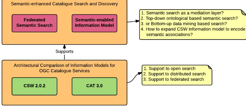
This OGC ER has two objectives. The first is a systematic comparison between the CSW 2.0.2 and the CSW 3.0 (CSW 3.0 and CAT 3.0 are used interchangeably) in terms of their architecture, and their support for open, distributed, and federated searches. The aim is to highlight the advancement of CSW 3.0 in terms of supporting metadata cataloguing and search in comparison to CSW 2.0.2. The second objective is to discuss potential semantic enhancement to catalogue services. This includes strategies of considering semantic search a mediation layer, or using ontology-based query expansion and reasoning, or using potentially some data mining approach to mine latent semantic associations
automatically to support semantic-enabled data discovery from distributed catalogs. This part will hopefully lead to the development of new standards for semantic-enabled catalogue service, making the catalog search more intelligent to serve needs within and beyond the geospatial community.
1.2 Document contributor contact points
All questions regarding this document should be directed to the editor or the contributors:
Name Organization
Wenwen Li Arizona State University Sheng Wu Arizona State University
1.3 Future work
1.4 Forward
Attention is drawn to the possibility that some of the elements of this document may be the subject of patent rights. The Open Geospatial Consortium shall not be held
responsible for identifying any or all such patent rights.
Recipients of this document are requested to submit, with their comments, notification of any relevant patent claims or other intellectual property rights of which they may be aware that might be infringed by any implementation of the standard set forth in this document, and to provide supporting documentation.
2 References
The following documents are referenced in this document. For dated references, subsequent amendments to, or revisions of, any of these publications do not apply. For undated references, the latest edition of the normative document referred to applies. OGC 06-121r3, OGC® Web Services Common Standard
NOTE This OWS Common Standard contains a list of normative references that are also applicable to this Implementation Standard.
OGC 07-006r1, OGC® Catalog Services Implementation Specification v2.0.2. OGC 12-168r4, OGC® Catalog Services Specification v3.0 –General Model.
3 Terms and definitions
For the purposes of this report, the definitions specified in Clause 4 of the OWS Common Implementation Standard [OGC 06-121r3], in OGC® Catalog Services Implementation Specification v2.0.2 [OGC 07-006r1] and OGC Catalogue Services Specification v 3.0 – General Model shall apply.
4 Conventions
4.1 Abbreviated terms
CSW Catalogue Services for the Web HTTP Hypertext Transfer Protocol
ISO International Organization for Standardization MIME Multipurpose Internet Mail Extensions
OGC Open Geospatial Consortium, also referred to as OpenGIS
UML Unified Markup Language
ebRIM Electronic business Registry Information Model
OWL Web Ontology Language
RDF Resource Description Framework SPARQL Semantic Web Query Language
SWEET Semantic Web for Earth and Environmental Terminology
DC Dublin Core
PURL Persistent Universal Resource Locator URI Universal Resource Identifier
4.2 UML notation
Most diagrams that appear in this standard are presented using the Unified Modeling Language (UML) static structure diagram, as described in Subclause 5.2 of [OGC 06-121r3].
4.3 Used parts of other documents
This document uses significant parts of documents OGC CSW 2.0.2 OGC 07-006r1 and OGC CSW 3.0 12-168r4. To reduce the need to refer to that document, this document copies some of those parts with small modifications. The copied part is cited in the document.
5 OGC IP Engineering Report on Catalogue Service Discovery overview
Figure 1. Research question to answer in the catalogue service ER We first conducted a systematic review and comparison of the two catalogue service standards. The comparison is generally based on the support capacity for open, distributed, and federated searches. These three search types are important for future catalogue implementation because (1) open search is widely supported by general search engines. Thus, enabling open search makes the metadata within the catalogue easily discoverable and shared; and (2) the rapid explosion of the Web makes it possible to connect physically distributed people and more importantly distributed geospatial assets. Geospatial data is an information resource known to be widely distributed in today’s computing paradigms. To support this broad distribution, various catalogue applications have been established. Well known ones include European Union’s INSPIRE1 catalogue,
the US data.gov2 project initiated by the US White House, and the international effort
GEOSS (Global Earth Observation System of Systems) 3. These Web-based catalog
services are hosted by different organizations and the metadata contained in them is most always on different topics. To increase the visibility of distributed geospatial data/service resources, there is a need for a federated distributed search mechanism that can
coordinate the data discovery process from not only one but many distributed catalogue instances.
Many organizations or applications often require access to distributed catalogues. Each set of these catalogues is used in a federated search. In another words one federated search requires the support from a subset of all distributed catalogs, and different
1 http://inspire-geoportal.ec.europa.eu/
2 http://data.gov
federated searches may or may not have overlapping catalogues. This ER discusses CSW 3.0’s capacity to support open, distributed, and federated searches in detail.
In addition, we discuss the possible solutions to semantically enable data search and discovery in CSW catalogues. These include the more traditional semantic mediation approach and two new methods for enabling triple storage and semantic query based on semantic association definition and Semantic Web technology. Recommendations for adopting these techniques in the CSW catalogue are made based on the advantages and disadvantage of each techniques, as well as the difficulty in integrating the semantic techniques into existing CSW information models.
6 Status of Work
6.1 CSW 2.0.2: An introduction
CSW 2.0.2 is an OGC standard that supports the publishing of and searching for metadata about data, services, and related information objects. As an implementation standard, OGC 07-006r1 specifies the “interface between clients and catalogue services, through the presentation of abstract and implementation-specific models.” Using 07-0061 as a baseline catalogue standard, this section discusses the architecture of CSW 2.0.2 for supporting catalogue searches, its information model, and distributed searching.
6.1.1 Reference Model Architecture
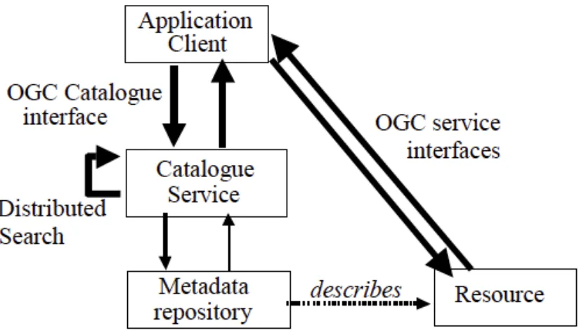
Figure 2. Reference Model Architecture (OGC 07-006r1)
In the 2.0.2 version of CSW standard, distributed search is mentioned. As seen in Figure 2, the catalogue service has an arrow to point to itself, in the aim of supporting distributed search. However, in the description of class definition, information model, and especially the operations, this version of CSW is still mainly focusing on solving the search and discovery in a local environment.
6.1.2 Operations Unique to CSW 2.0.2
A “Session” class is unique to CSW 2.0.2. Figure 2 defines the catalogue UML static model (Figure 3). In this model, there is a “Session” class. This class provides four operations to foster the interaction between server and client. The “initialize” and “close” operations start and end an interactive session. The “status” operation retrieves current status of a session, and “cancel” operation terminates an existing session.
The advantage of session is to allow the server to record the status of a user operation at the client side to better support a data retrieval process. As long as the session is alive, even if the webpage is accidentally closed, the server would still be able to recover to the previous state. However, the session strategy requires the server to store a variety of status information for the client. In a distributed search environment, the synchronization of such status information across different CSW servers will become extremely difficult. The server would also suffer from overloading and its performance will likely be
Figure 3. General OGC catalogue UML static model (OGC 07-006r1) CSW 2.0.2 also provides a full definition of the “Present” operation, which allows the retrieval of a result set that is related to the previous inquired set. For instance, a client can acquire a subset of a previous queried result or obtain more results with the cursor moving to the end of records returned in a previous query.
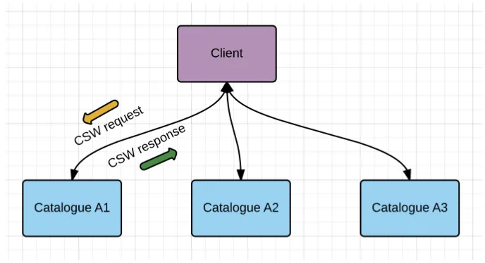
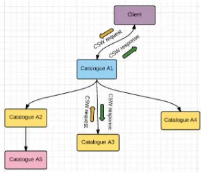
6.1.3 Support to Distributed Search
In CSW 2.0.2, the required components to enable distributed searching are discussed. First, a multi-tier reference architecture is needed to support cataloging and searching for geospatial data. This architecture diagram is discussed in section 6.1.1. Second, a data model is needed to describe how distributed search can be redirected to different catalogs. Third, the definition of communication messages needs to apply current catalog
information model to distributed search context.
interconnected graph, a search is conducted from current catalogue to the sub-catalogs that connect with it. Setting a maxLevel to 2 will allow the search of sub-catalogs that directly link to the current catalog, or those that are two steps further from the current catalog. In another words, they are the catalogs that link with the direct sub-catalogs of the current catalog. Setting a maxLevel to -1 will enable a search for all sub-catalogues from the current level. Using the parameter maxLevel, the query scope can be controlled. In CSW 2.0.2, potential problems of distributed catalog search are also discussed and described. In Annex B of the standard, two problematic scenarios are defined. The first problem is when one node X has two parent nodes. In this case, when a search is conducted, i.e., from a node that is the precedent of both the parent nodes, the node X will be searched twice, causing duplication in the result. The second problem is caused by a complex topology of the catalog network. For example, when catalog Y is linked to catalog Z, which is its precedent, catalog Z becomes Y’s child node too. In this case, a loop is formed, whereby a search that redirects to Z will fall in a repeated search between Y and Z causing serious issues. Although these problems are discussed, this version of specification did not describe how to solve these problems by extending the definition of the CSW information model.
6.1.4 Usability
The CSW 2.0.2 standard has been widely used in national and international spatial data infrastructure projects. Below we list a sample set of CSW endpoints that were
discovered by the NSF PolarHub, a large-scale web crawler for discovering distributed OGC services (Li et al. 2015):
CSW Catalogs URL
United States Geoscience Information Network Metadata Catalog
http://catalog.usgin.org/geoportal/csw?request=GetCapabilitie s&service=csw
GEOSS CSR Catalog http://geossregistries.info/geonetwork/srv/en/csw?Request=Ge tCapabilities&Service=CSW&Version=2.0.2
ArcGIS Server Geoportal Extension 10 - OGC CSW 2.0.2 ISO AP
http://catalog.chesapeakebay.net/geoportal/csw?Request=Get Capabilities&Service=CSW&Version=2.0.2
ArcGIS Online CSW Interface http://geoss.esri.com/csw/csw?request=GetCapabilities&servi ce=CSW&version=2.0.2
ArcGIS Server Geoportal Extension 10 - OGC CSW 2.0.2 ISO AP
http://portal.westcoastoceans.org/geoportal/csw?request=GetC apabilities&service=CSW&version=2.0.2
Servicio de catalogación OGC CSW de IDECA
http://metadatos.ideca.gov.co/geoportal/csw?request=GetCapa bilities&service=CSW
10 - OGC CSW 2.0.2 ISO AP etCapabilities&service=CSW&version=2.0.2
IARC Data Archive CSW Service http://climate.iarc.uaf.edu/geonetwork/srv/csw?REQUEST=G etCapabilities&SERVICE=CSW&VERSION=2.0.2
CSW Geospatial Catalogue for NOAA Data Catalog (data.noaa.gov)
https://data.noaa.gov/csw?request=GetCapabilities&service=C SW&version=2.0.2
Welsh Government INSPIRE CSW http://inspire.wales.gov.uk/metadata/srv/eng/csw?REQUEST= GetCapabilities&service=CSW&version=2.0.2
geocat.ch http://www.geocat.ch/geonetwork/srv/eng/csw?REQUEST=G etCapabilities&SERVICE=CSW&VERSION=2.0.2
UK Location Catalogue Publishing Service
Catalogue Service Land Steiermark (Geoportal Server 1.2.2) - OGC CSW 2.0.2 ISO API including INSPIRE Network Service Capabilities
North Dakota GIS Hub Data Portal httpshttp://apps.nd.gov/hubdataportal/srv/en/csw?REQUEST=GetCa pabilities&service=CSW&version=2.0.2
VLIZ Geonetwork http://geonetwork.vliz.be/geonetwork/srv/en/csw?request=Get Capabilities&service=CSW
Table 1. A list of sample CSW 2.0.2 endpoints
6.2 CSW 3.0
6.2.1 Introduction
• Restructuring the specification document according to the OGC standard for modular specifications (OGC 08-131r3, also know as Core and Extension model). • Incorporating the current mass-market technologies for discovery on the Web
(namely OpenSearch).
• Providing a better scenario design to support distributed and federated search. The standard contains the following main content:
• General Model
• Hypertext Transfer Protocol (HTTP) Protocol Binding. In CSW, the GET/KVP encoding is mandatory. The POST/XML encoding is optional. SOAP is supported as a special case of the POST/XML encoding.
• The OpenSearch is mandatory in CSW 3.0, no matter which implementation profile is used in the catalogue instance. The OpenSearch Geospatial and Temporal Extensions (OGC 10-032r2) are also included in CSW 3.0
specification. This document specifies spatial (e.g. point-plus-radius, bounding box, polygons, in EPSG:4326/WGS84 coordinates) and temporal constraints (e.g. time start/end) for searching.
• Additional changes include enhancement to query distribution and conformance classes.
6.2.2 General model
The general model of catalogue service defined in CSW 3.0 is the same as that defined in CSW 2.0.2. Refer to Figure 2.
6.2.3 A new definition in CSW3.0: Conformance class
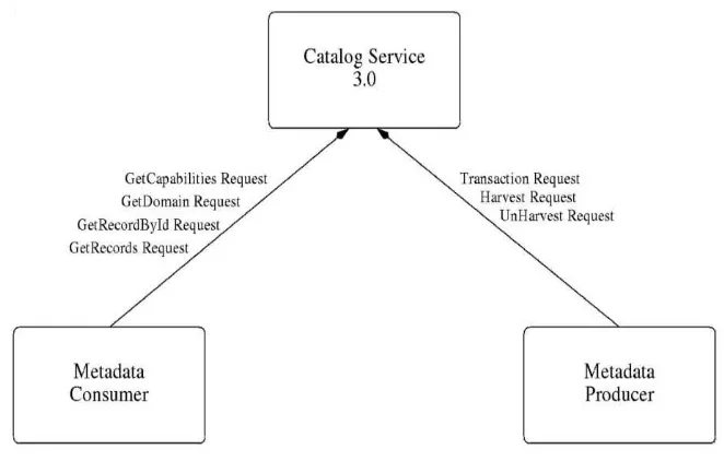
For conformance, the standard defines a set of requirements for which all catalogue implementations must conform. This is a new feature not included in the CSW 2.0.2 standard. Twelve conformance classes are defined:
• Query language: aiming at using a well-performed syntax to process full text and fielded query.
• Classified-as: This is an enhancement of current search support to introduce semantic-based query. Besides the support for keyword-based search, a classified-as operator allows queries bclassified-ased on taxonomy.
• Common-queryables: to support distributed search, different catalog instances need to make available a common set of queryable elements, such as title or abstract.
• Common-returnable: similar to “Common-queryables”, the Common-returnable defines a common set of elements that should be included in the returned
documents from different catalogues to support interoperability.
• GetCapabilities: All implementations should provide a means to request structured capability information about the CSW service.
• GetResourceById: All implementations should be able to provide a means to request a record by its ID.
• Query: The CSW instances should support the execution of a query request formed in a KVP or structured format.
• Describe-Records: This is also a requirement for the CSW instances to provide a means to describe the metadata information of a record.
• GetDomain: The catalogue should provide the domain (the value range) of a queryable such that a query can be formulated accordingly.
• Transaction: A transaction operation should allow the actions of adding, updating and deleting records to be performed on a catalog.
• Harvest: The harvest operation allows the retrieval of a resource from another remote catalog.
Figure 4. Conceptual architecture of CSW 3.0
6.2.4 Support to OpenSearch
6.2.4.1 Introduction
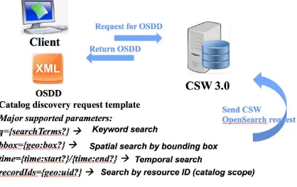
OpenSearch is a new feature in CSW 3.0 definition. A CSW server should provide a common set of formats conforming to the OpenSearch specification to help search engines and search clients discover geo-resources. By providing links in the Capabilities document to an OpenSearch Description Document of CSW (which include URI and query template), data in the CSW catalog can be accessed by the OpenSearch API. CSW completes the Vertical-Search/Deep-Search job because it is good at understanding the geospatial data. OpenSearch acts as an adapter between the CSW catalog and the common search engines and clients, making CSW searchable by an open API.
OpenSearch Geospatial Extension4: The purpose of the OpenSearch-Geo extensions is to provide a standard mechanism to query a resource based on geographic extents, or location name. The geospatial results are based on the GeoRSS standard. Therefore, latitude/longitude order, bounding box parameters are using that defacto standard. Spatial search include query classes: bounding box search, arbitrary geometry search, and
proximity search. (geo-extends draft 2).
OpenSearch Temporal Extension: Temporal search includes a Time search and Temporal relation search. Time search can be filtered by time instance of a time period. Temporal relation can be described as After, Before, Begins, During, Ends and so on.
OpenSearch Query Interface: The Catalog Service 3.0 SWG recommends that the OGC Technical Committee approve using the Fast Track process for OGC Document Number 10-032 “OpenSearch Query Interface” as an OGC Candidate Standard.
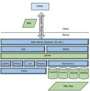
6.2.4.2 PyCSW: an open source tool to support CSW3.0/Open Search
PyCSW is an open source OGC CSW server implementation that allows publishing and sharing of geospatial metadata. This project started in 2010 and is written in Python. PyCSW is light-weighted; this python library can be easily integrated into any python-based application. It also has the ability of hosting multiple CSW with a single
installation. PyCSW uses database as backend data storage for metadata management. It supports robust testing and continuous integration.
Figure 5. PyCSW architecture diagram (http://geopython.github.io/pycsw-workshop/_images/pycsw-software-architecture.jpg)
6.2.4.3 Testbed 11 deployment of CSW 3.0 server
During testbed 11, the GMU team used PyCSW to deploy a CSW 3.0 server with OpenSearch support. This section introduces the CSW 3.0 instance and its support of different queries and open search.
6.2.4.3.1 Service endpoint
The endpoint of CSW server is hosted at:
• http://www2.csiss.gmu.edu:9009/cat3/csw
6.2.4.3.2 CSW 3.0 GetCapabilities request/response
A GetCapabilities request can be formed using the below format:
A response XML for the GetCapabilities request is:
<csw:Capabilities
xmlns="http://www.opengis.net/cat/csw/3.0" xmlns:csw="http://www.opengis.net/cat/csw/3.0" xmlns:fes="http://www.opengis.net/fes/2.0" xmlns:gml="http://www.opengis.net/gml/3.2" xmlns:ows20="http://www.opengis.net/ows/2.0" xmlns:gmd="http://www.isotc211.org/2005/gmd" xmlns:xlink="http://www.w3.org/1999/xlink"
xmlns:xsi="http://www.w3.org/2001/XMLSchema-instance" xmlns:geo="http://a9.com/-/opensearch/extensions/geo/1.0/"
xmlns:time="http://a9.com/-/opensearch/extensions/time/1.0/" version="3.0.0" xsi:schemaLocation="http://www.opengis.net/cat/csw/3.0
http://www.opengis.net/gml/3.2 http://schemas.opengis.net/gml/3.2.1/gml.xsd http://www.w3.org/1999/xlink http://www.w3.org/1999/xlink.xsd">
<ows20:ServiceIdentification>
<ows20:Title>Catalogue Service for Spatial Information</ows20:Title> <ows20:Abstract>
Catalogue Service for Spatial Information for OWS-11 (implemented based on pyCSW) </ows20:Abstract>
<ows20:Keywords>
<ows20:Keyword>catalog</ows20:Keyword> <ows20:Keyword>discovery</ows20:Keyword> <ows20:Keyword>metadata</ows20:Keyword>
<ows20:Type codeSpace="ISOTC211/19115">theme</ows20:Type> </ows20:Keywords>
<ows20:ServiceType>CSW</ows20:ServiceType>
<ows20:ServiceTypeVersion>3.0.0</ows20:ServiceTypeVersion> </ows20:ServiceIdentification>
<ows20:ServiceProvider>
<ows20:ProviderName>CSISS/GMU</ows20:ProviderName>
<ows20:ProviderSite xlink:type="simple" xlink:href="http://csiss.gmu.edu/"/> <ows20:ServiceContact>
<ows20:IndividualName>Di, Liping</ows20:IndividualName> <ows20:PositionName>Director & Professor</ows20:PositionName> <ows20:ContactInfo>
<ows20:Phone>
<ows20:Voice>703-993-6114</ows20:Voice>
<ows20:Facsimile>703-993-6127</ows20:Facsimile> </ows20:Phone>
<ows20:DeliveryPoint>4400 University Dr, MSN </ows20:ServiceProvider> <ows20:OperationsMetadata>
<ows20:Operation name="GetCapabilities"> <ows20:DCP>
</ows20:Parameter>
<ows20:Constraint name="OpenSearchDescriptionDocument"> <ows20:AllowedValues>
<ows20:Value>apiso:Type</ows20:Value>
</ows20:Constraint>
<ows20:Constraint name="SupportedDublinCoreQueryables"> <ows20:AllowedValues>
</ows20:AllowedValues>
<ows20:Constraint name="OpenSearch"> <ows20:AllowedValues>
<ows20:Value>TRUE</ows20:Value> </ows20:AllowedValues>
<ows20:DefaultValue>TRUE</ows20:DefaultValue> </ows20:Constraint>
<!-- GetCapabilities-XML support ? -->
<ows20:Constraint name="GetCapabilities-XML"> <ows20:AllowedValues>
<ows20:Value>true</ows20:Value> </ows20:AllowedValues>
</ows20:Constraint>
<!-- GetRecordById-XML support ? -->
<ows20:Constraint name="GetRecordById-XML"> <ows20:AllowedValues>
<ows20:Value>true</ows20:Value> </ows20:AllowedValues>
</ows20:Constraint>
<!-- GetRecords-Basic-XML support ? -->
<ows20:Constraint name="GetRecords-Basic-XML"> <ows20:AllowedValues>
<ows20:Value>true</ows20:Value> </ows20:AllowedValues>
</ows20:Constraint>
<!-- GetRecords-Distributed-XML support ? -->
<ows20:Constraint name="GetRecords-Distributed-XML"> <ows20:AllowedValues>
<ows20:Value>false</ows20:Value> </ows20:AllowedValues>
</ows20:Constraint>
<!-- GetRecords-Distributed-KVP support ? -->
<ows20:Constraint name="GetRecords-Distributed-KVP"> <ows20:AllowedValues>
</ows20:Constraint>
<!-- GetRecords-Async-XML support ? -->
<ows20:Constraint name="GetRecords-Async-XML"> <ows20:AllowedValues>
<ows20:Value>false</ows20:Value> </ows20:AllowedValues>
</ows20:Constraint>
<!-- GetRecords-Async-KVP support ? -->
<ows20:Constraint name="GetRecords-Async-KVP"> <ows20:AllowedValues>
<ows20:Value>false</ows20:Value> </ows20:AllowedValues>
</ows20:Constraint>
<!-- GetDomain-XML support ? -->
<ows20:Constraint name="GetDomain-XML"> <ows20:AllowedValues>
<ows20:Value>false</ows20:Value> </ows20:AllowedValues>
</ows20:Constraint>
<!-- GetDomain-KVP support ? -->
<ows20:Constraint name="GetDomain-KVP"> <ows20:AllowedValues>
<ows20:Value>false</ows20:Value> </ows20:AllowedValues>
</ows20:Constraint>
<!-- Harvest-Basic-XML support ? -->
<ows20:Constraint name="Harvest-Basic-XML"> <ows20:AllowedValues>
<ows20:Value>false</ows20:Value> </ows20:AllowedValues>
</ows20:Constraint>
<!-- Harvest-Basic-KVP support ? -->
<ows20:Constraint name="Harvest-Basic-KVP"> <ows20:AllowedValues>
<ows20:Value>false</ows20:Value> </ows20:AllowedValues>
</ows20:Constraint>
<!-- Harvest-Async-XML support ? -->
<ows20:Constraint name="Harvest-Async-XML"> <ows20:AllowedValues>
<ows20:Value>false</ows20:Value> </ows20:AllowedValues>
</ows20:Constraint>
<!-- Harvest-Async-KVP support ? -->
<ows20:Value>false</ows20:Value> </ows20:AllowedValues>
</ows20:Constraint>
<!-- Harvest-Periodic-XML support ? -->
<ows20:Constraint name="Harvest-Periodic-XML"> <ows20:AllowedValues>
<ows20:Value>false</ows20:Value> </ows20:AllowedValues>
</ows20:Constraint>
<!-- Harvest-Periodic-KVP support ? -->
<ows20:Constraint name="Harvest-Periodic-KVP"> <ows20:AllowedValues>
<ows20:Value>false</ows20:Value> </ows20:AllowedValues>
</ows20:Constraint>
<!-- support Transaction ? -->
<ows20:Constraint name="Transaction"> <ows20:AllowedValues>
<ows20:Value>false</ows20:Value> </ows20:AllowedValues>
</ows20:Constraint>
<!-- Filter-CQL support ? -->
<ows20:Constraint name="Filter-CQL"> <ows20:AllowedValues>
<ows20:Value>true</ows20:Value> </ows20:AllowedValues>
</ows20:Constraint>
<!-- Filter-FES support ? -->
<ows20:Constraint name="Filter-FES"> <ows20:AllowedValues>
<ows20:Value>true</ows20:Value> </ows20:AllowedValues>
</ows20:Constraint>
<!-- Filter-FES-XML support ? -->
<ows20:Constraint name="Filter-FES-XML"> <ows20:AllowedValues>
<ows20:Value>false</ows20:Value> </ows20:AllowedValues>
</ows20:Constraint>
<!-- Filter-FES-KVP-Advanced support ? -->
<ows20:Constraint name="Filter-FES-KVP-Advanced"> <ows20:AllowedValues>
<ows20:Value>false</ows20:Value> </ows20:AllowedValues>
<!-- Filter-KVP support ? -->
<ows20:Constraint name="Filter-KVP"> <ows20:AllowedValues>
<ows20:Value>true</ows20:Value> </ows20:AllowedValues>
</ows20:Constraint>
<!-- CSW-Response support ? -->
<ows20:Constraint name="CSW-Response"> <ows20:AllowedValues>
<ows20:Value>true</ows20:Value> </ows20:AllowedValues>
</ows20:Constraint>
<!-- ATOM-response support ? -->
<ows20:Constraint name="ATOM-response"> <ows20:AllowedValues>
<ows20:Value>true</ows20:Value> </ows20:AllowedValues>
</ows20:Constraint>
<ows20:Constraint name="CoreQueryables"> <ows20:AllowedValues>
<ows20:Constraint name="CoreSortables"> <ows20:AllowedValues>
<ows20:Constraint name="DefaultSortingAlgorithm"> <ows20:AllowedValues>
<ows20:Languages>
<ows20:Language>en</ows20:Language> </ows20:Languages>
<fes:Filter_Capabilities
xmlns:ows11="http://www.opengis.net/ows/1.1"> <fes:Conformance>
<fes:Operator name="Like"/>
<fes:Operator name="NotEqualTo"/> <fes:Operator name="NullCheck"/> </fes:AdditionalOperators>
</fes:Extended_Capabilities> </fes:Filter_Capabilities> </csw:Capabilities>
6.2.4.3.3 CSW 3.0 transaction support
The deployed CSW 3.0 server supports different transaction activities: add, update and delete. For example, an ADD request can be sent to the server through HTTP POST to insert a record. A sample ADD request is as follows:
<gmd:northBoundLatitude>
An UPDATE request can be sent to the server through HTTP POST to update the metadata information about a data record. A sample UPDATE request is demonstrated below:
<gco:Decimal>180</gco:Decimal> </gmd:eastBoundLongitude>
<gmd:southBoundLatitude>
<gco:Decimal>-90</gco:Decimal> </gmd:southBoundLatitude>
<gmd:northBoundLatitude>
<gco:Decimal>90</gco:Decimal> </gmd:northBoundLatitude>
</gmd:EX_GeographicBoundingBox> </gmd:geographicElement>
</gmd:EX_Extent> </gmd:extent>
</gmd:MD_DataIdentification> </gmd:identificationInfo>
</gmd:MD_Metadata> </csw:Update>
</csw:Transaction>
A DELETE request can be sent to the server through HTTP POST to delete an existing record. A sample DELETE request follows:
<csw:Transaction xmlns:ogc="http://www.opengis.net/ogc" xmlns:csw="http://www.opengis.net/cat/csw/2.0.2"
xmlns:ows="http://www.opengis.net/ows"
xmlns:xsi="http://www.w3.org/2001/XMLSchema-instance" xsi:schemaLocation="http://www.opengis.net/cat/csw/2.0.2
http://schemas.opengis.net/csw/2.0.2/CSW-publication.xsd" service="CSW" version="2.0.2">
<csw:Delete>
<csw:Constraint version="1.1.0"> <ogc:Filter>
<ogc:PropertyIsEqualTo>
<ogc:PropertyName>apiso:Identifier</ogc:PropertyName> <ogc:Literal>12345</ogc:Literal>
</ogc:PropertyIsEqualTo> </ogc:Filter>
</csw:Constraint> </csw:Delete> </csw:Transaction>
6.2.4.3.4 CSW 3.0 Metadata discovery
• Search metadata through OGC CSW 3.0 GetRecords
o Request metadata with 'csw:Record' as output metadata schema
http://www2.csiss.gmu.edu:9009/cat3/csw?service=CSW&version =3.0.0&request=GetRecords&resultType=results&ElementSetNa me=full&outputSchema=http://www.opengis.net/cat/csw/2.0.2&ty penames=csw:Record&outputFormat=application/xml&startPositi on=1&maxRecords=10&constraintlanguage=CQL_TEXT&constr aint=csw%3AAnyText%20Like%20%27%25a%25%27
o Responded XML is:
<csw:GetRecordsResponse xmlns:csw="http://www.opengis.net/cat/csw/3.0"
xmlns:dc="http://purl.org/dc/elements/1.1/"
xmlns:rim="urn:oasis:names:tc:ebxml-regrep:xsd:rim:3.0"
xmlns:atom="http://www.w3.org/2005/Atom"
xmlns:xs="http://www.w3.org/2001/XMLSchema"
xmlns:dct="http://purl.org/dc/terms/" xmlns:ows="http://www.opengis.net/ows"
xmlns:ows2="http://www.opengis.net/ows/2.0"
xmlns:apiso="http://www.opengis.net/cat/csw/apiso/1.0"
xmlns:gml="http://www.opengis.net/gml"
xmlns:xlink="http://www.w3.org/1999/xlink"
xmlns:gco="http://www.isotc211.org/2005/gco"
xmlns:gmd="http://www.isotc211.org/2005/gmd"
xmlns:rdf="http://www.w3.org/1999/02/22-rdf-syntax-ns#"
xmlns:srv="http://www.isotc211.org/2005/srv"
xmlns:ogc="http://www.opengis.net/ogc"
xmlns:xsi="http://www.w3.org/2001/XMLSchema-instance" xmlns:os=
"http://a9.com/-/spec/opensearch/1.1/"
xmlns:sitemap="http://www.sitemaps.org/schemas/sitemap/0.9"
xmlns:wrs="http://www.opengis.net/cat/wrs/1.0" version="2.0.2"
xsi:schemaLocation="http://www.opengis.net/cat/csw/3.0
../../../csw/3.0/CSW30-discovery.xsd">
<csw:SearchStatus timestamp="2015-07-07T15:13:04Z" />
<csw:SearchResults numberOfRecordsReturned="10" nextRecord="11"
numberOfRecordsMatched="12" recordSchema="http://www.opengis.net/cat/csw/3.0"
elementSet="full">
<csw:Record>
<dc:identifier>
</dc:identifier>
<dc:title>VASDI Alaska Mapped WMS</dc:title>
<dc:type>service</dc:type>
<dc:subject>service</dc:subject>
<dc:subject>N/A</dc:subject>
<dc:subject>N/A</dc:subject>
<dct:references scheme="WWW:LINK-1.0-http--link">
http://wms.alaskamapped.org/cgi-bin/bdl.cgi?request=GetCapabilities&service=WMS
</dct:references>
<dct:references scheme="WWW:LINK-1.0-http--link">
http://wms.alaskamapped.org/cgi-bin/bdl.cgi?request=GetCapabilities&service=WMS
</dct:references>
<dct:modified>2009-07-20</dct:modified>
<dct:abstract>
Alaska Mapped - Alaska Statewide Digital Mapping Initiative WMS
</dct:abstract>
<dc:date>2009-07-20</dc:date>
<dc:language>eng</dc:language>
<ows2:BoundingBox crs="urn:ogc:def:crs:EPSG::4326" dimensions="2">
<ows2:LowerCorner>-90.0 -180.0</ows2:LowerCorner>
<ows2:UpperCorner>90.0 180.0</ows2:UpperCorner>
</ows2:BoundingBox>
</csw:Record>
<csw:Record>
<dc:identifier>
urn:ogc:ows11:service:urn:uuid:21fa4afd-b60d-47de-8da0-bf35e55e7774
</dc:identifier>
<dc:title>Test</dc:title>
<dc:type/>
<dc:subject>service</dc:subject>
<dc:subject>Flickr</dc:subject>
<dc:subject>Youtube</dc:subject>
<dct:references scheme="None">
http://ows.usersmarts.com/ldscraper/api/types/flickr
</dct:references>
<dct:references scheme="None">
http://ows.usersmarts.com/ldscraper/api/types/flickr/scrape
</dct:references>
http://ows.usersmarts.com/ldscraper/api/types/youtube
</dct:references>
<dct:references scheme="None">
http://ows.usersmarts.com/ldscraper/api/types/youtube/scrape
</dct:references>
<dct:modified>2015-05-05</dct:modified>
<dct:abstract>Test</dct:abstract>
<dc:date>2015-05-05</dc:date>
<dc:language>eng</dc:language>
<ows2:BoundingBox crs="urn:ogc:def:crs:EPSG::4326" dimensions="2">
<ows2:LowerCorner>-90.0 -180.0</ows2:LowerCorner>
<ows2:UpperCorner>90.0 180.0</ows2:UpperCorner>
</ows2:BoundingBox>
</csw:Record>
<csw:Record>
<dc:identifier>
urn:ogc:ows11:service:urn:uuid:21fa4afd-b60d-47de-8da0-bf22e55e7774
</dc:identifier>
<dc:title>
Geomatys WCS (Constellation-SDI) serving San Francisco and Mozambique coverage
data
</dc:title>
<dc:type/>
<dc:subject>service</dc:subject>
<dc:subject>San Francisco</dc:subject>
<dc:subject>Mozambique</dc:subject>
<dc:subject>TOPOBATHY</dc:subject>
<dc:subject>San Francisco bay</dc:subject>
<dc:subject>SRTM</dc:subject>
<dc:subject>DEM</dc:subject>
<dc:subject>Digital elevation model</dc:subject>
<dc:subject>WCS</dc:subject>
<dct:references scheme="None">
http://ows11.geomatys.com/constellation/WS/wcs/default?REQUEST=GetCapabilities&
SERVICE=WCS&VERSION=2.0.1
</dct:references>
<dct:modified>2015-05-05</dct:modified>
Geomatys WCS (Constellation-SDI) serving San Francisco and Mozambique coverage
data
</dct:abstract>
<dc:date>2015-05-05</dc:date>
<dc:language>eng</dc:language>
<ows2:BoundingBox crs="urn:ogc:def:crs:EPSG::4326" dimensions="2">
<ows2:LowerCorner>-90.0 -180.0</ows2:LowerCorner>
<ows2:UpperCorner>90.0 180.0</ows2:UpperCorner>
</ows2:BoundingBox>
</csw:Record>
<csw:Record>
<dc:identifier>
urn:ogc:ows11:service:urn:uuid:21fbsbfd-b35d-11de-8da0-bf22e55e7774
</dc:identifier>
<dc:title>IBM Cloudant WFS (OGC Web Feature Service)</dc:title>
<dc:type/>
<dc:subject>service</dc:subject>
<dc:subject>highway</dc:subject>
<dc:subject>Open street map</dc:subject>
<dc:subject>OSM</dc:subject>
<dc:subject>emergency facilities</dc:subject>
<dc:subject>San Francisco</dc:subject>
<dc:subject>WFS</dc:subject>
<dc:subject>Web feature service</dc:subject>
<dct:references
scheme="None">http://ogcwfs.mybluemix.net/wfs/2.5</dct:references>
<dct:modified>2015-05-05</dct:modified>
<dct:abstract>
This service implements the emerging RESTful interface of the Web Feature
Service standard. This interface is under development and not yet published
outside of the WFS Working Group of the Open Geospatial Consortium. It's
brought to you by the Geo team at IBM Cloudant.
</dct:abstract>
<dc:date>2015-05-05</dc:date>
<dc:language>eng</dc:language>
<ows2:BoundingBox crs="urn:ogc:def:crs:EPSG::4326" dimensions="2">
<ows2:LowerCorner>-90.0 -180.0</ows2:LowerCorner>
<ows2:UpperCorner>90.0 180.0</ows2:UpperCorner>
</csw:Record>
<csw:Record>
<dc:identifier>
urn:ogc:ows11:service:urn:uuid:21fa4afd-b60d-12de-8da0-bf22e55e7774
</dc:identifier>
<dc:title>Luciad WCS (OGC Web Coverage Service)</dc:title>
<dc:type/>
<dc:subject>service</dc:subject>
<dc:subject>Monterey bay imagery</dc:subject>
<dc:subject>black marble</dc:subject>
<dc:subject>blue marble</dc:subject>
<dc:subject>San Francisco</dc:subject>
<dc:subject>Mozambique</dc:subject>
<dc:subject>TOPOBATHY</dc:subject>
<dc:subject>San Francisco bay</dc:subject>
<dc:subject>SRTM</dc:subject>
<dc:subject>DEM</dc:subject>
<dc:subject>Digital elevation model</dc:subject>
<dc:subject>Topo50 topographic map</dc:subject>
<dc:subject>WCS</dc:subject>
<dc:subject>Web coverage service</dc:subject>
<dct:references scheme="None">
http://demo.luciad.com:8080/LuciadFusion/wcs?REQUEST=GetCapabilities&SERVICE=WC
S
</dct:references>
<dct:modified>2015-05-05</dct:modified>
<dct:abstract>
The OGC WCS focuses on delivering raster data. This component provides an
OGC-certified implementation of version 1.0.0.
</dct:abstract>
<dc:date>2015-05-05</dc:date>
<dc:language>eng</dc:language>
<ows2:BoundingBox crs="urn:ogc:def:crs:EPSG::4326" dimensions="2">
<ows2:LowerCorner>-90.0 -180.0</ows2:LowerCorner>
<ows2:UpperCorner>90.0 180.0</ows2:UpperCorner>
</ows2:BoundingBox>
</csw:Record>
<dc:identifier>
urn:ogc:ows11:service:urn:uuid:21fa4afd-b35d-11de-8da0-bf22e55e7774
</dc:identifier>
<dc:title>Luciad WFS (OGC Web Feature Service)</dc:title>
<dc:type/>
<dc:subject>service</dc:subject>
<dc:subject>buoy</dc:subject>
<dc:subject>Open street map</dc:subject>
<dc:subject>OSM</dc:subject>
<dc:subject>New Zealand</dc:subject>
<dc:subject>US county</dc:subject>
<dc:subject>US city</dc:subject>
<dc:subject>US river</dc:subject>
<dc:subject>US aviation obstacle</dc:subject>
<dc:subject>San Francisco</dc:subject>
<dc:subject>Mozambique</dc:subject>
<dc:subject>WFS</dc:subject>
<dc:subject>Web feature service</dc:subject>
<dc:subject>Monterey oil spill</dc:subject>
<dc:subject>Monterey sounding</dc:subject>
<dc:subject>US coast</dc:subject>
<dc:subject>Hydro line</dc:subject>
<dc:subject>vent</dc:subject>
<dc:subject>hydrology</dc:subject>
<dct:references scheme="None">
http://demo.luciad.com:8080/LuciadFusion/wfs?REQUEST=GetCapabilities&SERVICE=WF
S
</dct:references>
<dct:modified>2015-05-05</dct:modified>
<dct:abstract>
The OGC WFS focuses on exchanging vector data. This component provides an
OGC-certified implementation of version 1.0.0 and 1.1.0.
</dct:abstract>
<dc:date>2015-05-05</dc:date>
<dc:language>eng</dc:language>
<ows2:BoundingBox crs="urn:ogc:def:crs:EPSG::4326" dimensions="2">
<ows2:LowerCorner>-90.0 -180.0</ows2:LowerCorner>
<ows2:UpperCorner>90.0 180.0</ows2:UpperCorner>
</csw:Record>
<csw:Record>
<dc:identifier>
urn:ogc:ows11:service:urn:uuid:21fa4afd-b60d-11de-8da0-bf22e55e7774
</dc:identifier>
<dc:title>Luciad WMS (OGC Web Map Service)</dc:title>
<dc:type/>
<dc:subject>service</dc:subject>
<dc:subject>Monterey bay imagery</dc:subject>
<dc:subject>black marble</dc:subject>
<dc:subject>blue marble</dc:subject>
<dc:subject>buoy</dc:subject>
<dc:subject>Open street map</dc:subject>
<dc:subject>OSM</dc:subject>
<dc:subject>New Zealand</dc:subject>
<dc:subject>US county</dc:subject>
<dc:subject>US city</dc:subject>
<dc:subject>US river</dc:subject>
<dc:subject>US aviation obstacle</dc:subject>
<dc:subject>San Francisco</dc:subject>
<dc:subject>Mozambique</dc:subject>
<dc:subject>TOPOBATHY</dc:subject>
<dc:subject>San Francisco bay</dc:subject>
<dc:subject>SRTM</dc:subject>
<dc:subject>DEM</dc:subject>
<dc:subject>Digital elevation model</dc:subject>
<dc:subject>Topo50 topographic map</dc:subject>
<dc:subject>WMS</dc:subject>
<dc:subject>Web map service</dc:subject>
<dct:references scheme="None">
http://demo.luciad.com:8080/LuciadFusion/wms?REQUEST=GetCapabilities&SERVICE=WM
S
</dct:references>
<dct:modified>2015-05-05</dct:modified>
<dct:abstract>
The OGC WMS focuses on delivering portrayed data. This component provides an
for dimensions, the Queryable profile (GetFeatureInfo), and the Styled Layer
Descriptor profile.
</dct:abstract>
<dc:date>2015-05-05</dc:date>
<dc:language>eng</dc:language>
<ows2:BoundingBox crs="urn:ogc:def:crs:EPSG::4326" dimensions="2">
<ows2:LowerCorner>-90.0 -180.0</ows2:LowerCorner>
<ows2:UpperCorner>90.0 180.0</ows2:UpperCorner>
</ows2:BoundingBox>
</csw:Record>
<csw:Record>
<dc:identifier>
urn:ogc:ows11:service:urn:uuid:33fa4afd-b60d-11de-8da0-bf22e55e7774
</dc:identifier>
<dc:title>Luciad WMTS (OGC Web Map Tile Service)</dc:title>
<dc:type/>
<dc:subject>service</dc:subject>
<dc:subject>Monterey bay imagery</dc:subject>
<dc:subject>black marble</dc:subject>
<dc:subject>blue marble</dc:subject>
<dc:subject>Mozambique</dc:subject>
<dc:subject>Maritime map</dc:subject>
<dc:subject>Web map tile service</dc:subject>
<dct:references scheme="None">
http://demo.luciad.com:8080/LuciadFusion/wmts?REQUEST=GetCapabilities&SERVICE=W
MTS
</dct:references>
<dct:modified>2015-05-05</dct:modified>
<dct:abstract>
The OGC WMTS focuses on delivering tiles. This component provides an
implementation of version 1.0.0 of the standard.
</dct:abstract>
<dc:date>2015-05-05</dc:date>
<dc:language>eng</dc:language>
<ows2:BoundingBox crs="urn:ogc:def:crs:EPSG::4326" dimensions="2">
<ows2:LowerCorner>-90.0 -180.0</ows2:LowerCorner>
<ows2:UpperCorner>90.0 180.0</ows2:UpperCorner>
</ows2:BoundingBox>
<csw:Record>
<dc:identifier>
urn:ogc:ows11:service:urn:uuid:21fa3nfd-b60d-11de-8da0-bf22e55e7774
</dc:identifier>
<dc:title>North 52 WPS (OGC Web Processing Service)</dc:title>
<dc:type/>
<dc:subject>service</dc:subject>
<dc:subject>FloodFeatureEnrichment</dc:subject>
<dc:subject>FloodImpactAssessment</dc:subject>
<dc:subject>Flooding</dc:subject>
<dc:subject>Natural disaster</dc:subject>
<dc:subject>GCAM</dc:subject>
<dc:subject>Global Change Assessment Model</dc:subject>
<dc:subject>Flood risk</dc:subject>
<dc:subject>Flood assessment</dc:subject>
<dc:subject>WPS</dc:subject>
<dc:subject>Web processing service</dc:subject>
<dc:subject>geoprocessing</dc:subject>
<dct:references scheme="None">
http://ows.dev.52north.org:8080/wps/WebProcessingService?Request=GetCapabilitie
s&Service=WPS&acceptversions=2.0.0
</dct:references>
<dct:modified>2015-05-05</dct:modified>
<dct:abstract>
Service based on the 52°North implementation of WPS 1.0.0
</dct:abstract>
<dc:date>2015-05-05</dc:date>
<dc:language>eng</dc:language>
<ows2:BoundingBox crs="urn:ogc:def:crs:EPSG::4326" dimensions="2">
<ows2:LowerCorner>-90.0 -180.0</ows2:LowerCorner>
<ows2:UpperCorner>90.0 180.0</ows2:UpperCorner>
</ows2:BoundingBox>
</csw:Record>
<csw:Record>
<dc:identifier>
urn:ogc:ows11:service:urn:uuid:21fa3afa-b60d-21de-8da0-bf22e55e7774
</dc:identifier>
<dc:type/>
<dc:subject>service</dc:subject>
<dc:subject>Geonames</dc:subject>
<dc:subject>Hydrological point</dc:subject>
<dc:subject>Cultural</dc:subject>
<dc:subject>Landform</dc:subject>
<dc:subject>Community</dc:subject>
<dc:subject>Historical</dc:subject>
<dc:subject>Hydrological line</dc:subject>
<dc:subject>Antarctica</dc:subject>
<dc:subject>Transportation</dc:subject>
<dc:subject>Administrative</dc:subject>
<dc:subject>WFS</dc:subject>
<dc:subject>Web feature service</dc:subject>
<dct:references scheme="None">
http://services.nationalmap.gov/arcgis/services/WFS/geonames/MapServer/WFSServe
r?request=GetCapabilities&service=WFS
</dct:references>
<dct:modified>2015-05-05</dct:modified>
<dct:abstract>USGS Geoname WFS (OGC Web Feature Service)</dct:abstract>
<dc:date>2015-05-05</dc:date>
<dc:language>eng</dc:language>
<ows2:BoundingBox crs="urn:ogc:def:crs:EPSG::4326" dimensions="2">
<ows2:LowerCorner>-90.0 -180.0</ows2:LowerCorner>
<ows2:UpperCorner>90.0 180.0</ows2:UpperCorner>
</ows2:BoundingBox>
</csw:Record>
</csw:SearchResults>
</csw:GetRecordsResponse>
o Request metadata with 'ebRIM' as output metadata schema
http://www2.csiss.gmu.edu:9009/cat3/csw?service=CSW&version =3.0.0&request=GetRecords&resultType=results&ElementSetNa
guage=CQL_TEXT&constraint=csw%3AAnyText%20Like%20% 27%25a%25%27
The response XML can be found at:
<csw:GetRecordsResponse xmlns:csw="http://www.opengis.net/cat/csw/3.0" xmlns:dc="http://purl.org/dc/elements/1.1/"
xmlns:rim="urn:oasis:names:tc:ebxml-regrep:xsd:rim:3.0" xmlns:atom="http://www.w3.org/2005/Atom"
xmlns:xs="http://www.w3.org/2001/XMLSchema"
xmlns:dct="http://purl.org/dc/terms/" xmlns:ows="http://www.opengis.net/ows" xmlns:ows2="http://www.opengis.net/ows/2.0"
xmlns:xsi="http://www.w3.org/2001/XMLSchema-instance" xmlns:os= "http://a9.com/-/spec/opensearch/1.1/"
xmlns:sitemap="http://www.sitemaps.org/schemas/sitemap/0.9" xmlns:wrs="http://www.opengis.net/cat/wrs/1.0" version="2.0.2"
xsi:schemaLocation="http://www.opengis.net/cat/csw/3.0 ../../../csw/3.0/CSW30-discovery.xsd">
<csw:SearchStatus timestamp="2015-07-07T15:18:33Z" />
<csw:SearchResults numberOfRecordsReturned="10" nextRecord="11" numberOfRecordsMatched="12" recordSchema= "urn:oasis:names:tc:ebxml-regrep:xsd:rim:3.0" elementSet="full">
<rim:ExtrinsicObject xsi:schemaLocation="http://www.opengis.net/cat/wrs/1.0 http://schemas.opengis.net/csw/2.0.2/profiles/ebrim/1.0/csw-ebrim.xsd"
id="urn:geoss:csr:service:urn:uuid:21fa4afd-b60d-47de-8da0-bf35e55e7774" lid="urn:geoss:csr:service:urn:uuid:21fa4afd-b60d-47de-8da0-bf35e55e7774" objectType="service" status=
"urn:oasis:names:tc:ebxml-regrep:StatusType:Submitted">
<rim:VersionInfo versionName="" />
<rim:ExternalIdentifier registryObject="None" identificationScheme="foo" id="urn:geoss:csr:service:urn:uuid:21fa4afd-b60d-47de-8da0-bf35e55e7774" value="urn:geoss:csr:service:urn:uuid:21fa4afd-b60d-47de-8da0-bf35e55e7774" /> <rim:Name>
<rim:LocalizedString value="VASDI Alaska Mapped WMS" /> </rim:Name>
<rim:Description>
<rim:LocalizedString value="Alaska Mapped - Alaska Statewide Digital Mapping Initiative WMS" />
</rim:Description>
<rim:Slot slotType="urn:ogc:def:dataType:ISO-19107:2003:GM_Envelope"> <rim:ValueList>
<ows2:BoundingBox crs="urn:ogc:def:crs:EPSG::4326" dimensions="2">
<rim:Slot name="http://purl.org/dc/elements/1.1/subject"> <rim:ValueList>
<rim:ExtrinsicObject xsi:schemaLocation="http://www.opengis.net/cat/wrs/1.0 http://schemas.opengis.net/csw/2.0.2/profiles/ebrim/1.0/csw-ebrim.xsd"
id="urn:ogc:ows11:service:urn:uuid:21fa4afd-b60d-47de-8da0-bf35e55e7774" lid="urn:ogc:ows11:service:urn:uuid:21fa4afd-b60d-47de-8da0-bf35e55e7774" objectType="None" status=
"urn:oasis:names:tc:ebxml-regrep:StatusType:Submitted">
<rim:VersionInfo versionName="" />
<rim:ExternalIdentifier registryObject="None" identificationScheme="foo" id="urn:ogc:ows11:service:urn:uuid:21fa4afd-b60d-47de-8da0-bf35e55e7774" value="urn:ogc:ows11:service:urn:uuid:21fa4afd-b60d-47de-8da0-bf35e55e7774" /> <rim:Name>
<rim:LocalizedString value="Test" /> </rim:Name>
<rim:Description>
<rim:LocalizedString value="Test" /> </rim:Description>
<rim:Slot slotType="urn:ogc:def:dataType:ISO-19107:2003:GM_Envelope"> <rim:ValueList>
<rim:Value>
<ows2:BoundingBox crs="urn:ogc:def:crs:EPSG::4326" dimensions="2"> <ows2:LowerCorner>-90.0 -180.0</ows2:LowerCorner>
<rim:Slot name="http://purl.org/dc/elements/1.1/subject"> <rim:ValueList>
<rim:ExtrinsicObject xsi:schemaLocation="http://www.opengis.net/cat/wrs/1.0 http://schemas.opengis.net/csw/2.0.2/profiles/ebrim/1.0/csw-ebrim.xsd"
objectType="None" status= "urn:oasis:names:tc:ebxml-regrep:StatusType:Submitted">
<rim:VersionInfo versionName="" />
<rim:ExternalIdentifier registryObject="None" identificationScheme="foo" id="urn:ogc:ows11:service:urn:uuid:21fa4afd-b60d-47de-8da0-bf22e55e7774" value="urn:ogc:ows11:service:urn:uuid:21fa4afd-b60d-47de-8da0-bf22e55e7774" /> <rim:Name>
<rim:LocalizedString value="Geomatys WCS (Constellation-SDI) serving San Francisco and Mozambique coverage data" />
</rim:Name>
<rim:Description>
<rim:LocalizedString value="Geomatys WCS (Constellation-SDI) serving San Francisco and Mozambique coverage data" />
</rim:Description>
<rim:Slot slotType="urn:ogc:def:dataType:ISO-19107:2003:GM_Envelope"> <rim:ValueList>
<rim:Value>
<ows2:BoundingBox crs="urn:ogc:def:crs:EPSG::4326" dimensions="2"> <ows2:LowerCorner>-90.0 -180.0</ows2:LowerCorner>
<rim:Slot name="http://purl.org/dc/elements/1.1/subject"> <rim:ValueList>
<rim:Value>service</rim:Value> <rim:Value>San Francisco</rim:Value> <rim:Value>Mozambique</rim:Value> <rim:Value>TOPOBATHY</rim:Value>
<rim:Value>San Francisco bay</rim:Value> <rim:Value>SRTM</rim:Value>
<rim:Value>DEM</rim:Value>
<rim:Value>Digital elevation model</rim:Value> <rim:Value>WCS</rim:Value>
</rim:ValueList> </rim:Slot>
</rim:ExtrinsicObject>
<rim:ExtrinsicObject xsi:schemaLocation="http://www.opengis.net/cat/wrs/1.0 http://schemas.opengis.net/csw/2.0.2/profiles/ebrim/1.0/csw-ebrim.xsd"
id="urn:ogc:ows11:service:urn:uuid:21fbsbfd-b35d-11de-8da0-bf22e55e7774" lid="urn:ogc:ows11:service:urn:uuid:21fbsbfd-b35d-11de-8da0-bf22e55e7774" objectType="None" status=
"urn:oasis:names:tc:ebxml-regrep:StatusType:Submitted">
<rim:VersionInfo versionName="" />
<rim:ExternalIdentifier registryObject="None" identificationScheme="foo" id="urn:ogc:ows11:service:urn:uuid:21fbsbfd-b35d-11de-8da0-bf22e55e7774" value="urn:ogc:ows11:service:urn:uuid:21fbsbfd-b35d-11de-8da0-bf22e55e7774" /> <rim:Name>
<rim:LocalizedString value="IBM Cloudant WFS (OGC Web Feature Service)" /> </rim:Name>