JOURNAL OF GREEN SCIENCE AND TECHNOLOGY
ANALYSIS OF HYDROLOGY OF THE KALIGUNG RIVER AT
TEGAL
Disty Prasanty*, Saihul Anwar**
*) Student of Civil Engineering Major, Faculty of Engineering, University of Swadaya Gunung Jati Cirebon **) Lecturer of Civil Engineering Major, Faculty of Engineering, University of Swadaya Gunung Jati Cirebon
ABSTRACT
Rivers drain water by embracing a gravitational philosophy, in which water always flows from
high to low or downstream to downstream. The process of river water flow is an endless natural process,
closing the hydrological cycle by restoring the river runoff to the sea. For centuries, rivers have been
used as a source of clean water, meeting human needs for drinking water, sanitation, irrigation, and so
on. Large rivers are dammed to store water in the wet season and use it in the dry season for various
purposes.
Kali Gung or Kaligung or also known as Kaligung river is a river that flows in Tegal regency,
Central Java. This river is one of the largest rivers in Tegal besides Kali Ketiwon and Kali Kemiri. This
river is called Kali Gung because it is tangent to the spring that comes from Mount Agung is an ancient
name from Mount Slamet in pre-Islamic times in Java. Upstream or spring water Kaligung located in
the north of Mount Slamet and empties to the north precisely in the sea of Java.
1. BACKGROUND
Kali Gung or Kaligung or also known as Kaligung river is a river that flows in Tegal regency, Central Java. This river is one of the largest rivers in Tegal besides Kali Ketiwon and Kali Kemiri. This river is called Kali Gung because it is tangent to the spring that comes from Mount Agung is an ancient name from Mount Slamet in pre-Islamic times in Java. Upstream or spring water Kaligung located in the north of Mount Slamet and empties to the north precisely in the sea of Java.
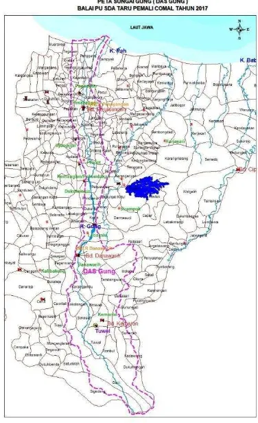
Gung River is located in Gung river basin
(DAS) area of 765,625 km2 which includes
Tegal regency and Tegal city with main river length about 55,58 km.
River management, in general, is a technical, administrative, legal, regulatory and management matters concerning river facilities
and buildings, Forest observations,
maintenance and repair of doors and drainage facilities, flood forecasting, flood warning and countermeasures and others -other. To be able to realize it requires supporting facilities
and infrastructure optimally include analyzing River Gung Hydrology.
2. FORMULATION OF THE
PROBLEM
The problems and conditions need to be
the implementation of the review of
countermeasures and improvements as follows:
1. Is the potential for water and discharge
sufficient?
2. How much flood discharge the gung river
plan?
3. INTENT AND PURPOSE
OF RESEARCH
The following purposes of the study of River Gung Hydrology Analysis are:
1. Analyzing the discharge to be utilized the
potential of water availability optimally, to serve the Irrigation area.
2. Analyzing flood prevention on the river
4. STUDY AREAS LOCATION
The study location that will be discussed in this final project report is gung river.
Overall DAS gung area of 765,625 km2 is
located in Tegal.
Figure 1. Das Maps of Rivers Gung
5. FRAMEWORK
6. THEORETICAL BASIS
8.1 Hydrology
Hydrology is derived from the Greek Hydrologia which means water science, etymologically hydrology consists of the word hydro and logy where ''hydro'' means water and '' logos '' means science, so hydrology can be a said water problem. In general, hydrology is the study of the problem of water existence on earth and hydrology itself provides alternative for the development of water resources for the purposes of raw water, industrial agriculture and electricity.
8.2 Watershed
Watersheds are a land area which is a unity with rivers and tributaries, which functions to accommodate, store, and drain water from rainfall to the lake or to the sea naturally, whose boundaries on land are topographical and boundary separators in the sea up to the waters area that is still affected by the mainland activities.
8.3 Hydrological Cycle
The hydrologic cycle is actually very complex and has a wide scope so for the analysis, it is necessary to simplify the model to represent the actual state. To determine the relationship between rainfall, flow and evaporation this can be explained by the hydrological cycle.
8.4 River
The river is a large and long flow of water that flows continuously from upstream (source) to downstream (estuary). Water in rivers is generally collected from precipitation, such as rain, dew, springs, underground runoff, and in certain countries also comes from melt ice/snow. In addition to water, rivers also drain sediment and pollutants.
8.5 Rainfall
Rain is one of the natural phenomena contained in the hydrological cycle and strongly influenced by climate. The existence of rain is very important in life because rain can meet the water needs that are needed by all living things.
8.6 Water Availability
In general in Indonesia, which is a benchmark in irrigation planning is the planning of irrigation water needs for rice crops. The need for rice crops for rice varieties often used in Indonesia is 1 liter/second/hectare average, or the average height of rice puddle is 10 cm.
8.7 Flood
Floods are usually regarded as rising river water levels that exceed their normal state or in the general sense of the overflow of water beyond the normal channel capacity limit. Floods are also defined as large streams of water, flowing water that floods and overflows the normally dry plains.
8.8 Plant Patterns
In cultivating, there are several planting patterns to be efficient and facilitate us in land use and to rearrange the planting calendar. Cropping pattern itself there are three kinds,
namely: monoculture, polyculture
(tumpangsari), and crop rotation.
7. DATA RESEARCH METHODS
In this study the data obtained by the way, as follows:
1. Looking for data of primary data and secondary data (at the related institution and department) needed to complete data needed for thesis preparation.
2. Study literature as a literature review both from books and other media (internet). 3. Processing and analyzing the data obtained.
Taking conclusions and suggestions from the results of thesis studies.
7.1 HYDROLOGY ANALYSIS METHOD
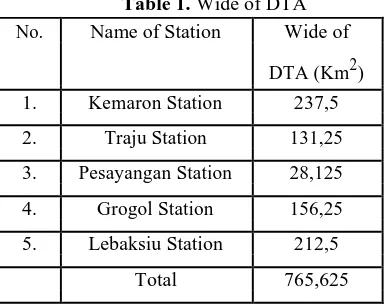
Some of the successful hydrological data collected come from several recording stations, such as manual rainfall scattered in several locations such as Kemaron Station, Lebaksiu Station, Grogol Station, Traju Station, and Pesayangan Station (located in DAS Gung). Hydrological analysis
conducted is as follows :
polygon method. A number of stations used as many as five rain stations. The need to calculate
the area's rainfall is for the preparation of a potential water plan.
Figure 3. Poligon Thiessen of Watershed
8.5.2 Mainstay Debit
For the mainstay discharge Q 80% of the average discharge taken within a certain time (10 years).
N = 80 % x n
Information :
N = year sequence whose Q is used as a mainstay debit
n = number of years of observation 8.5.3 Availability Debit
In general in Indonesia, which is a benchmark in irrigation planning is the planning of irrigation water needs for rice crops. Rice water requirement for rice varieties that are often used
in Indonesia is an average of 1
liter/second/hectare, or the average height of rice puddle is 10 cm.
8.5.4 Debit Requirement
In general, hydrological analysis is carried out: a. water demand analysis for irrigation water
demand planning
b. calculation of plan debit analysis to determine river cross-sectional capacity in flood control building planning
c. hydrological analysis for drainage water planning.
d. hydrological analysis for calculation of water potential in order to determine the volume of the reservoir plan
e. analysis of the relationship between rainfall and flow rate in order to develop a flood early warning system (Anwar, 2011).
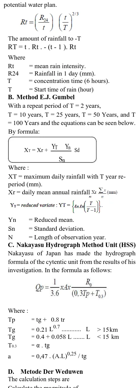
8.5.5 Flood Debit Analysis Plan A. Rain Distribution According to
Monobe
Average rain from scratch
The amount of rainfall to -T
RT = t . Rt . - (t - 1 ). Rt
WhereRt = mean rain intensity. R24 = Rainfall in 1 day (mm).
T = concentration time (6 hours).
T = Start time of rain (hour)
B. Method E.J. Gumbel
With a repeat period of T = 2 years,
T = 10 years, T = 25 years, T = 50 Years, and T = 100 Years and the equations can be seen below. By formula:
XT = Xr +
Y
TY
n SdS
n Where :XT = maximum daily rainfall with T year re-period (mm).
Xr = daily mean annual rainfall
Yn = Reduced mean.
Sn = Standard deviation.
N = Length of observation year.
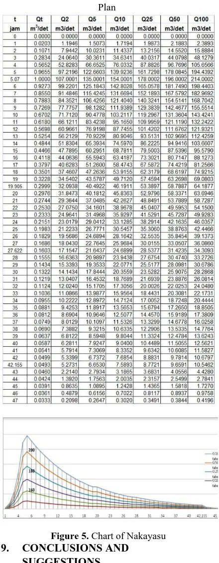
C. Nakayasu Hydrograph Method Unit (HSS) Nakayasu of Japan has made the hydrograph formula of the cytentic unit from the results of his investigation. In the formula as follows:
flood discharge by re-use the formula :
8. ANALYSIS AND DISCUSSION
PROBLEMS
8.1 DETERMINATION OF RIVER FLOWS
Based on thiessen polygon method results in the broadest catchment area as follows:
Table 1. Wide of DTA
No. Name of Station Wide of
DTA (Km2) 1. Kemaron Station 237,5
2. Traju Station 131,25
3. Pesayangan Station 28,125 4. Grogol Station 156,25
5. Lebaksiu Station 212,5
Total 765,625
8.2 RAINFALL ANALYSIS
Table 2. The Data of Rainfall from Kemaron Station
(Semimonthly) (2007-2016 mm)
Table 3. The Data of Rainfall from Lebaksiu Station
(Semimonthly) (2007-2016 mm)
Table 4. The Data of Rainfall from Grogol Station
(Semimonthly) (2007-2016 mm)
Table 5. The Data of Rainfall from Traju Station
(Semimonthly) (2007-2016 mm)
Table 5. The Data of Rainfall from Pesayangan
Station (Semimonthly) (2007-2016 mm)
8.3 POTENTIAL ANALYSIS OF WATER
8.3.1 Mainstay Debit
Table 6. Potential Calculations from Kemaron
Station (wide : 237,5 km2) (for example) Tahun Januari Pebruari Maret April Mei Juni
Jan-1 Jan-2 Peb-1 Peb-2 Mar-1 Mar-2 Apr-1 Apr-2 Mei-1 Mei-2 Jun-1 Jun-2 2007 25,650,000 42,275,000 108,775,000 38,712,500 37,762,500 70,775,000 62,225,000 61,037,500 39,425,000 19,712,500 20,900,000 4,275,000
2008 59,137,500 21,375,000 113,287,500 37,287,500 80,512,500 44,650,000 14,962,500 16,387,500 5,462,500 1,900,000 2,375,000 712,500
2009 24,700,000 37,287,500 44,887,500 34,437,500 - - - -
2010 106,400,000 118,750,000 101,650,000 63,887,500 68,637,500 53,675,000 22,800,000 57,237,500 71,487,500 29,687,500 46,312,500 19,237,500 2011 87,400,000 126,350,000 45,837,500 75,050,000 46,312,500 55,337,500 26,837,500 69,350,000 42,750,000 52,012,500 - 3,325,000
2012 81,700,000 75,287,500 35,150,000 130,862,500 123,500,000 23,750,000 90,250,000 57,475,000 38,000,000 23,750,000 2,375,000 950,000
2013 113,287,500 128,487,500 64,837,500 51,062,500 23,512,500 70,537,500 87,875,000 90,725,000 40,612,500 34,912,500 39,425,000 19,712,500 2014 22,087,500 149,862,500 103,787,500 52,250,000 28,737,500 58,900,000 65,075,000 57,237,500 33,487,500 55,337,500 9,975,000 44,175,000 2015 27,312,500 41,325,000 66,500,000 21,137,500 66,025,000 16,387,500 30,162,500 34,200,000 10,925,000 2,612,500 7,837,500 -
2016 21,137,500 49,400,000 45,837,500 75,050,000 60,562,500 28,975,000 26,837,500 69,350,000 31,350,000 43,937,500 33,725,000 36,812,500
Tahun Juli Agustus September Oktober Nopember Desember
Jul-1 Jul-2 Ags-1 Ags-2 Sep-1 Sep-2 Okt-1 Okt-2 Nop-1 Nop-2 Des-1 Des-2
2007 237,500 4,750,000 - 1,662,500 712,500 - 2,612,500 5,462,500 30,162,500 30,637,500 36,100,000 65,075,000 2008 - - 237,500 2,375,000 2,375,000 - 42,037,500 43,225,000 96,187,500 42,750,000 42,037,500 55,812,500 2009 - - - - - 21,137,500 37,050,000 24,225,000 81,462,500 2010 19,712,500 29,450,000 31,825,000 58,900,000 63,412,500 47,975,000 49,637,500 87,637,500 40,137,500 34,437,500 107,112,500 109,250,000 2011 1,187,500 5,462,500 - - - - 8,312,500 30,875,000 101,887,500 115,187,500 63,175,000 59,612,500 2012 - 1,662,500 - - - - 1,900,000 37,050,000 45,600,000 75,525,000 75,287,500 50,112,500 2013 44,887,500 23,987,500 - 13,062,500 15,912,500 6,412,500 - - 21,375,000 29,687,500 69,350,000 47,025,000 2014 16,150,000 14,012,500 30,637,500 2,612,500 - - - 16,150,000 23,512,500 38,712,500 46,550,000 41,562,500 2015 - - - 1,187,500 - - 1,187,500 2,375,000 25,175,000 33,487,500 68,637,500 36,812,500 2016 11,875,000 39,900,000 11,162,500 3,800,000 56,287,500 91,437,500 18,525,000 15,200,000 42,275,000 51,775,000 42,750,000 21,375,000
Table 7. Potential of Calculations Table of Kaligung
Watershed
Tahun Januari Pebruari Maret April Mei Juni
Jan-1 Jan-2 Peb-1 Peb-2 Mar-1 Mar-2 Apr-1 Apr-2 Mei-1 Mei-2 Jun-1 Jun-2
2007 104,613,750 115,781,250 233,362,500 137,718,750 110,209,375 145,718,750 113,512,500 143,965,625 84,240,625 62,993,750 81,328,125 8,925,000 2008 129,368,750 151,050,000 187,993,750 125,684,375 147,521,875 75,940,625 47,556,250 59,650,000 16,484,375 7,696,875 11,153,125 24,715,625 2009 101,368,750 167,310,938 190,993,750 170,734,375 63,596,875 52,700,000 38,993,750 34,484,375 48,590,625 21,706,250 7,703,125 837,500 2010 231,731,250 256,031,250 214,367,188 234,018,750 158,871,875 232,406,250 49,131,250 159,387,500 154,456,250 86,590,625 173,103,125 73,075,000 2011 165,177,813 207,549,938 222,646,875 231,265,625 144,756,250 179,018,750 106,931,250 88,687,500 108,146,875 95,156,250 8,921,875 6,446,875 2012 230,436,250 204,780,938 161,698,750 225,251,875 327,368,750 84,968,750 168,031,250 88,271,875 55,178,125 47,315,625 18,378,125 950,000 2013 244,446,875 255,534,375 139,572,188 122,420,625 100,356,250 129,968,750 183,078,125 138,634,375 51,546,875 83,184,375 121,534,375 40,159,375 2014 104,821,875 227,631,250 189,400,000 217,290,625 141,868,750 116,696,875 181,850,000 104,756,250 82,781,250 122,168,750 47,690,625 106,021,875 2015 183,450,000 182,462,500 211,100,000 106,559,375 203,112,500 78,453,125 72,896,875 210,365,625 57,108,125 22,904,688 27,962,500 84,375 2016 92,853,125 138,353,125 222,646,875 231,265,625 136,521,875 58,175,000 106,931,250 93,281,250 66,500,000 98,743,750 60,021,875 79,009,375 Tahun Juli Agustus September Oktober Nopember Desember
Jul-1 Jul-2 Ags-1 Ags-2 Sep-1 Sep-2 Okt-1 Okt-2 Nop-1 Nop-2 Des-1 Des-2
2007 7,762,500 24,800,000 - 1,662,500 712,500 - 14,081,250 30,818,750 92,459,375 81,703,125 93,471,875 226,806,250
2008 2,587,500 - 1,187,500 20,815,625 6,556,250 7,375,000 90,221,875 82,378,125 140,875,000 88,968,750 106,492,188 147,334,375
2009 - - - 196,875 - 253,125 16,931,250 1,515,625 82,736,458 113,409,375 89,650,000 191,915,625
2010 55,881,250 67,325,000 38,750,000 110,718,750 107,896,875 118,900,000 136,712,500 156,146,875 110,662,500 90,740,625 188,718,750 271,303,125
2011 11,843,750 17,071,875 - - 262,500 - 8,312,500 127,771,875 195,306,250 183,490,625 126,181,250 208,039,063
2012 - 1,846,875 - - - - 5,109,375 61,896,875 91,275,000 134,362,500 123,653,125 202,684,375
2013 137,687,500 54,137,500 - 35,068,750 27,706,250 12,981,250 781,250 13,181,250 64,100,000 77,156,250 153,946,875 145,537,500
2014 64,268,750 39,290,625 40,803,125 2,612,500 - - - 20,471,875 70,328,125 97,425,000 99,912,500 146,128,125
2015 - 356,250 356,250 1,187,500 - - 1,187,500 4,343,750 78,901,042 93,906,250 184,368,750 159,562,500
2016 31,093,750 69,487,500 21,146,875 14,493,750 83,046,875 203,818,750 65,762,500 73,040,625 115,046,875 124,331,250 166,284,375 123,825,000
Table 8. Potential of Calculation Table of Rice Field
(12504 Ha)
Tahun Januari Pebruari Maret April Mei Juni
Jan-1 Jan-2 Peb-1 Peb-2 Mar-1 Mar-2 Apr-1 Apr-2 Mei-1 Mei-2 Jun-1 Jun-2 2007 25,174,720 30,259,680 47,265,120 40,763,040 35,886,480 38,512,320 26,258,400 22,382,160 29,134,320 13,754,400 35,386,320 9,252,960 2008 46,514,880 53,642,160 28,634,160 53,642,160 13,129,200 14,379,600 35,761,440 13,004,160 875,280 375,120 14,629,680 13,379,280 2009 14,754,720 41,950,920 37,949,640 27,883,920 16,130,160 8,752,800 2,250,720 4,126,320 19,381,200 19,006,080 14,129,520 250,080
2010 14,254,560 24,007,680 37,949,640 27,758,880 8,127,600 30,009,600 8,502,720 16,255,200 11,253,600 8,627,760 13,129,200 9,002,880 2011 24,707,904 24,035,189 34,386,000 20,881,680 11,753,760 12,504,000 9,002,880 1,250,400 11,878,800 8,252,640 1,375,440 1,375,440 2012 19,306,176 18,893,544 22,307,136 34,185,936 22,257,120 8,252,640 16,505,280 6,627,120 1,875,600 2,875,920 7,877,520 -
2013 29,134,320 23,632,560 34,748,616 34,185,936 28,759,200 8,002,560 17,880,720 8,127,600 9,878,160 21,381,840 15,129,840 8,377,680 2014 20,131,440 19,006,080 14,254,560 15,880,080 10,503,360 7,377,360 16,005,120 750,240 3,000,960 18,756,000 125,040 7,127,280 2015 30,259,680 33,510,720 23,257,440 15,379,920 16,005,120 12,629,040 4,626,480 26,883,600 6,927,216 1,187,880 - 375,120
2016 15,630,000 25,133,040 34,386,000 20,881,680 16,880,400 3,751,200 9,002,880 1,250,400 1,750,560 7,752,480 625,200 6,627,120 Tahun Juli Agustus September Oktober Nopember Desember
Jul-1 Jul-2 Ags-1 Ags-2 Sep-1 Sep-2 Okt-1 Okt-2 Nop-1 Nop-2 Des-1 Des-2 2007 - - - 6,502,080 2,250,720 21,882,000 22,882,320 28,134,000 52,516,800 2008 11,503,680 - - 2,375,760 - - 11,128,560 5,626,800 11,753,760 19,006,080 17,380,560 40,137,840 2009 - - - 875,280 - 1,125,360 1,000,320 1,875,600 11,003,520 9,878,160 16,505,280 23,382,480 2010 9,252,960 10,253,280 3,251,040 24,507,840 3,626,160 7,002,240 12,504,000 10,628,400 12,754,080 10,628,400 13,254,240 17,130,480 2011 2,000,640 3,876,240 - - - - - 11,128,560 9,503,040 8,877,840 12,253,920 33,573,240 2012 - 125,040 - - - - 375,120 1,375,440 11,628,720 11,503,680 10,878,480 28,134,000 2013 7,502,400 3,501,120 - 1,250,400 - - - 250,080 12,253,920 12,504,000 23,132,400 18,505,920 2014 11,003,520 875,280 625,200 - - - - 1,625,520 9,378,000 9,753,120 10,753,440 20,131,440 2015 - 1,000,320 1,000,320 - - - - - 10,628,400 12,003,840 21,506,880 16,505,280 2016 7,502,400 2,750,880 875,280 3,501,120 4,376,400 18,756,000 11,253,600 12,629,040 8,127,600 9,753,120 33,135,600 20,006,400
Table 10. Potential of Calculation Table of
Watershed and Irrigation Area
Tahun Januari Pebruari Maret April Mei Juni
Jan-1 Jan-2 Peb-1 Peb-2 Mar-1 Mar-2 Apr-1 Apr-2 Mei-1 Mei-2 Jun-1 Jun-2
2007 129,788,470 146,040,930 280,627,620 178,481,790 146,095,855 184,231,070 139,770,900 166,347,785 113,374,945 76,748,150 116,714,445 18,177,960
2008 175,883,630 204,692,160 216,627,910 179,326,535 160,651,075 90,320,225 83,317,690 72,654,160 17,359,655 8,071,995 25,782,805 38,094,905
2009 116,123,470 209,261,858 228,943,390 198,618,295 79,727,035 61,452,800 41,244,470 38,610,695 67,971,825 40,712,330 21,832,645 1,087,580 2010 245,985,810 280,038,930 252,316,828 261,777,630 166,999,475 262,415,850 57,633,970 175,642,700 165,709,850 95,218,385 186,232,325 82,077,880
2011 189,885,717 231,585,126 257,032,875 252,147,305 156,510,010 191,522,750 115,934,130 89,937,900 120,025,675 103,408,890 10,297,315 7,822,315 2012 249,742,426 223,674,482 184,005,886 259,437,811 349,625,870 93,221,390 184,536,530 94,898,995 57,053,725 50,191,545 26,255,645 950,000
2013 273,581,195 279,166,935 174,320,804 156,606,561 129,115,450 137,971,310 200,958,845 146,761,975 61,425,035 104,566,215 136,664,215 48,537,055
2014 124,953,315 246,637,330 203,654,560 233,170,705 152,372,110 124,074,235 197,855,120 105,506,490 85,782,210 140,924,750 47,815,665 113,149,155
2015 213,709,680 215,973,220 234,357,440 121,939,295 219,117,620 91,082,165 77,523,355 237,249,225 64,035,341 24,092,568 27,962,500 459,495
2016 108,483,125 163,486,165 257,032,875 252,147,305 153,402,275 61,926,200 115,934,130 94,531,650 68,250,560 106,496,230 60,647,075 85,636,495 Tahun Juli Agustus September Oktober Nopember Desember
Jul-1 Jul-2 Ags-1 Ags-2 Sep-1 Sep-2 Okt-1 Okt-2 Nop-1 Nop-2 Des-1 Des-2 2007 7,762,500 24,800,000 - 1,662,500 712,500 - 20,583,330 33,069,470 114,341,375 104,585,445 121,605,875 279,323,050 2008 14,091,180 - 1,187,500 23,191,385 6,556,250 7,375,000 101,350,435 88,004,925 152,628,760 107,974,830 123,872,748 187,472,215 2009 - - - 1,072,155 - 1,378,485 17,931,570 3,391,225 93,739,978 123,287,535 106,155,280 215,298,105 2010 65,134,210 77,578,280 42,001,040 135,226,590 111,523,035 125,902,240 149,216,500 166,775,275 123,416,580 101,369,025 201,972,990 288,433,605 2011 13,844,390 20,948,115 - - 262,500 - 8,312,500 138,900,435 204,809,290 192,368,465 138,435,170 241,612,303 2012 - 1,971,915 - - - - 5,484,495 63,272,315 102,903,720 145,866,180 134,531,605 230,818,375 2013 145,189,900 57,638,620 - 36,319,150 27,706,250 12,981,250 781,250 13,431,330 76,353,920 89,660,250 177,079,275 164,043,420 2014 75,272,270 40,165,905 41,428,325 2,612,500 - - - 22,097,395 79,706,125 107,178,120 110,665,940 166,259,565 2015 - 1,356,570 1,356,570 1,187,500 - - 1,187,500 4,343,750 89,529,442 105,910,090 205,875,630 176,067,780 2016 38,596,150 72,238,380 22,022,155 17,994,870 87,423,275 222,574,750 77,016,100 85,669,665 123,174,475 134,084,370 199,419,975 143,831,400
Table 11. The Data of Debit Mainstay
No Ranking Januari Pebruari Maret April Mei Juni
Jan-1 Jan-2 Peb-1 Peb-2 Mar-1 Mar-2 Apr-1 Apr-2 Mei-1 Mei-2 Jun-1 Jun-2
1 I 273,581,195 280,038,930 280,627,620 261,777,630 349,625,870 262,415,850 200,958,845 237,249,225 165,709,850 140,924,750 186,232,325 113,149,155
2 II 249,742,426 279,166,935 257,032,875 259,437,811 219,117,620 191,522,750 197,855,120 175,642,700 120,025,675 106,496,230 136,664,215 85,636,495
3 III 245,985,810 246,637,330 257,032,875 252,147,305 166,999,475 184,231,070 184,536,530 166,347,785 113,374,945 104,566,215 116,714,445 82,077,880
4 IV 213,709,680 231,585,126 252,316,828 252,147,305 160,651,075 137,971,310 139,770,900 146,761,975 85,782,210 103,408,890 60,647,075 48,537,055
5 V 189,885,717 223,674,482 234,357,440 233,170,705 156,510,010 124,074,235 115,934,130 105,506,490 68,250,560 95,218,385 47,815,665 38,094,905
6 VI 175,883,630 215,973,220 228,943,390 198,618,295 153,402,275 93,221,390 115,934,130 94,898,995 67,971,825 76,748,150 27,962,500 18,177,960
7 VII 129,788,470 209,261,858 216,627,910 179,326,535 152,372,110 91,082,165 83,317,690 94,531,650 64,035,341 50,191,545 26,255,645 7,822,315
8 VIII 124,953,315 204,692,160 203,654,560 178,481,790 146,095,855 90,320,225 77,523,355 89,937,900 61,425,035 40,712,330 25,782,805 1,087,580
9 IX 116,123,470 163,486,165 184,005,886 156,606,561 129,115,450 61,926,200 57,633,970 72,654,160 57,053,725 24,092,568 21,832,645 950,000
10 X 108,483,125 146,040,930 174,320,804 121,939,295 79,727,035 61,452,800 41,244,470 38,610,695 17,359,655 8,071,995 10,297,315 459,495
potensi 20% 141,502,739 172,840,530 195,582,167 149,906,962 133,706,802 101,645,410 69,145,680 78,338,401 47,029,712 34,642,546 45,484,317 22,997,427 No Ranking Juli Agustus September Oktober Nopember Desember
Jul-1 Jul-2 Ags-1 Ags-2 Sep-1 Sep-2 Okt-1 Okt-2 Nop-1 Nop-2 Des-1 Des-2
1 I 145,189,900 77,578,280 42,001,040 135,226,590 111,523,035 222,574,750 149,216,500 166,775,275 204,809,290 192,368,465 205,875,630 288,433,605
2 II 75,272,270 72,238,380 41,428,325 36,319,150 87,423,275 125,902,240 101,350,435 138,900,435 152,628,760 145,866,180 201,972,990 279,323,050
3 III 65,134,210 57,638,620 22,022,155 23,191,385 27,706,250 12,981,250 77,016,100 88,004,925 123,416,580 134,084,370 199,419,975 241,612,303
4 IV 38,596,150 40,165,905 1,356,570 17,994,870 6,556,250 7,375,000 20,583,330 85,669,665 123,174,475 123,287,535 177,079,275 230,818,375
5 V 14,091,180 24,800,000 1,187,500 2,612,500 712,500 1,378,485 17,931,570 63,272,315 114,341,375 107,974,830 138,435,170 215,298,105
6 VI 13,844,390 20,948,115 - 1,662,500 262,500 - 8,312,500 33,069,470 102,903,720 107,178,120 134,531,605 187,472,215
7 VII 7,762,500 1,971,915 - 1,187,500 - - 5,484,495 22,097,395 93,739,978 105,910,090 123,872,748 176,067,780
8 VIII - 1,356,570 - 1,072,155 - - 1,187,500 13,431,330 89,529,442 104,585,445 121,605,875 166,259,565
9 IX - - - 781,250 4,343,750 79,706,125 101,369,025 110,665,940 164,043,420 10 X - - - - 3,391,225 76,353,920 89,660,250 106,155,280 143,831,400 potensi 20% 29,037,980 15,515,656 8,400,208 27,045,318 22,304,607 44,514,950 29,843,300 36,068,035 102,044,994 110,201,893 126,099,350 172,751,841
8.3.2 Debit Requirement
Table 9. Comparison of Debit Requirement and Potential Debit
MASA TANAM I
Mᵌ November Desember Januari Februari
I II I II I II I II
Data Debit Kebutuhan 28,075,481 28,075,481 23,396,234 23,396,234 18,716,988 18,716,988 11,698,117 11,698,117
Data Debit Potensi 102,044,994 110,201,893 126,099,350 172,751,841 141,502,739 172,840,530 195,582,167 149,906,962
MASA TANAM III
Mᵌ Juli Agustus September Oktober
I II I II I II I II
Data Debit Kebutuhan 19,653,286 19,653,286 16,377,738 16,377,738 13,102,191 13,102,191 8,188,869 8,188,869
Data Debit Potensi 29,037,980 15,515,656 8,400,208 27,045,318 22,304,607 44,514,950 29,843,300 36,068,035
Figure 4. Comparison Chart Between Available Discharge with Half-monthly Requirement Discharge
MASA TANAM II
Mᵌ Maret April Mei Juni
I II I II I II I II
Data Debit Kebutuhan 28,075,481 28,075,481 23,396,234 23,396,234 18,716,988 18,716,988 11,698,117 11,698,117
Data Debit Potensi 133,706,802 101,645,410 69,145,680 78,338,401 47,029,712 34,642,546 45,484,317 22,997,427
8.4 ANALYSIS OF HYDROLOGY AND RAINFALL
In Rainfall Analysis which will be used is Gumbel Method, and Weduwen Method. 8.4.1 Gumbel Method Analysis
Table 10. Resume of Rainfall Rise Calculation
Result (R) Gumbel Method
Periode Ulang Stasiun Rata-rata
Kemaron Lebaksiu Grogol Traju Pesayangan
R2 107 102 116 114 111 107 of max rainfall from the five stations in use Thiesen method to get the rainfall region in each station on each specific repeat period.
With an area of A = 765,625 km2.
8.5 FLOOD DEBIT ANALYSIS PLAN
The design debit analysis should use the discharge data from the relevant river but since there is no debit data available, then to analyze the discharge plan will use rainfall data. Flood discharge planning analysis using Weduwen method analysis and HSS Nakayasu method.
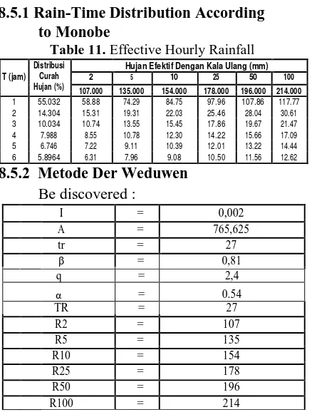
Hujan Efektif Dengan Kala Ulang (mm)
T (jam) 2 5 10 25 50 100
Table 12. Flood Discharge Plan by Weduwen
Method
8.5.3 Flood Debit Plan (HSS Nakayasu) To get the flood discharge plan, then the up and down hydrograph arch is done in Table 4. The following:
Watershed area (A) = 765 km2 (Result of calculation).
Table 13. Resume Debit Flood Hydrograf Nakayasu
Plan
Figure 5. Chart of Nakayasu
9. CONCLUSIONS AND
SUGGESTIONS 9.1 CONCLUSIONS
From the analysis of the analysis that has been done can be drawn several conclusions as follows:
1. Kaligung River Basin is 765,625 km2. 2. From the above comparison results obtained
the highest reliable debit occurred in
February 195.582.167 m3 and the lowest potential discharge in August of 8,400.208 m3.
3. The results of detailed rain records in the semi-monthly rainfall of the dry season run between May to October and the rainy season between November and April. 4. Modified cropping pattern for Tegal
irrigation area three times
• For Planting Season I (MT I) the need for water for rice crops with planted area of 12,504 hectares, the mainstay discharge is greater than the demand discharge then irrigation water needs can be fulfilled continuously.
• For the Planting Season II (MT II) water needs for rice crops with planted area of 12,504 hectares.
• For the Planting Season III (MT III) the need for water for rice crops with an area of 8.753 hectares of total area of 12,504 hectares due to potential discharge at the end of July until early August is insufficient.
• The flood discharge calculation with method of the Nakayasu was Q25 = 187
m3/second.
10. SUGGESTIONS
Based on the results of the analysis the author can provide suggestions as follows:
1. The availability of water potential from five rainfall stations should be optimized so that the intensity for maximum cultivation. 2. The result of cropping pattern analysis to be
a reference or reference for the service 3. Further research is needed, so that the river
hydrological analysis can be utilized more optimally
4. The data obtained should be checked whether it is in accordance with the actual conditions.
REFERENCES
A. Books
Haeruddin, 2012. Evaluasi Kinerja Sistem
Bendung Walahar di
SungaiCiwaringin Kab. Cirebon. Eki Danet, 2016. Analisis Hidrologi Bendungan
Cipanas Kabupaten Sumedang.
Yudha Prigadi, 2016.Analisis Hidrologi
Bendungan Ujung Jaya Kabupaten
Budhiono,R.M. 2011.Kajian Sistem Jaringan Irigasi Rentang pada Saluran Induk Utara Kab.Indramayu.
Karim, 2016. Analisis Hidrologi Sungai Citaal. Eprints.undip.ac.id
http://www.ebiologi.com/2016/03/siklus- hidrologi-pengertian-proses.html www.Scribd.com