FINAL PROJECT REPORT - RA.141581
BLURRING BOUNDARIES
JOYOBOYO INTERMODAL TRANSPORTATION HUB
Rr ARINTA RATIH NURINDAHSARI 3213100054
SUPERVISOR:
JOHANES KRISDIANTO, S.T., M.T.
UNDERGRADUATE PROGRAMME DEPARTMENT OF ARCHITECTURE
FACULTY OF CIVIL ENGINERING AND PLANNING INSTITUT TEKNOLOGI SEPULUH NOPEMBER SURABAYA
FINAL PROJECT REPORT - RA.141581
BLURRING BOUNDARIES
JOYOBOYO INTERMODAL TRANSPORTATION HUB
Rr ARINTA RATIH NURINDAHSARI 3213100054
SUPERVISOR:
JOHANES KRISDIANTO, S.T., M.T.
UNDERGRADUATE PROGRAM DEPARTMENT OF ARCHITECTURE
FACULTY OF CIVIL ENGINERING AND PLANNING INSTITUT TEKNOLOGI SEPULUH NOPEMBER SURABAYA
ABSTRAK
TANPA BATAS
PUSAT TRANSPORTASI ANTARMODA JOYOBOYO
oleh
Rr Arinta Ratih N.
NRP: 3213100054
Ruang bukanlah hal yang nyata, dan perlu ditentukan oleh seperangkat batasan untuk menciptakan perbedaan antara dua wilayah. Batas itu sendiri bisa diklasifikasikan sebagai batas fisik dan batas psikologis. Namun ruang tidak hanya didefinisikan oleh batas-batas yang kokoh tetapi juga oleh batas-batas seperti furnitur, garis, langkah dan platform yang tembus pandang, atau bahkan batas-batas maya yang tidak terlihat secara fisik namun terasa jelas.
Surabaya sedang merencanakan sebuah Transit Oriented Development; sebuah area terintegrasi untuk memberikan kualitas hidup yang lebih baik. Salah satu ide utamanya adalah Terminal Joyoboyo, yang akan mengakomodasi beberapa moda transportasi, seperti bus pariwisata, monorel, trunk, feeder, taksi, dan tempat parkir untuk kendaraan pribadi, yang kemudian menimbulkan masalah; bagaimana mengintegrasikan kawasan dengan pusat terminal antarmoda yang disebutkan sebelumnya, ke dalam bangunan dengan batas yang minimum, sehingga sesuai dengan konsep TOD.
ABSTRACT
BLURRING BOUNDARIES
JOYOBOYO INTERMODAL TRANSPORTATION HUB
by
Rr Arinta Ratih N.
NRP: 3213100054
Space is not a tangible matter, and it is need to be defined by set of boundaries to create the distinction between two areas. Boundaries itself can be classified as physical boundary and psychological boundary. Yet a space is not merely defined by solid boundaries but also by translucent boundaries, furniture, lines, steps and platforms, or even virtual boundaries that are not physically visible but mentally evident.
Surabaya is planning a Transit Oriented Development; where an area is integrated to provide better quality of living. One of the main idea is Terminal Joyoboyo, which will accommodate several transportation modes, such as tourism bus, monorail, trunk, feeder, taxi, and parking lot for private vehicle, which then leads to the problem; how to integrate the area with the intermodal terminal hub stated before, into a building with fewer boundaries, so that it will suit the TOD concept.
CONTENTS
STATEMENT OF VALIDITY ... I STATEMENT OF ORIGINALITY ... II CONTENTS ... V LIST OF FIGURES ... VI LIST OF TABLES ... VII
CHAPTER I INTRODUCTION ... 1
I.1 ISSUE BACKGROUND ... 1
I.2 ISSUE AND DESIGN CONTEXT ... 1
CHAPTER II ... 5
PROGRAMMING ... 5
II.1 PROGRAMMING ... 5
CHAPTER III DESIGN APPROACH & METHOD ... 15
III.1 DESIGN APPROACH ... 15
III.2 DESIGN METHOD ... 15
CHAPTER IV DESIGN CONCEPT ... 17
IV.1 FORMAL EXPLORATION ... 17
CHAPTER V DESIGN ... 21
V.1 FORMAL EXPLORATION ... 21
V.2 TECHNICAL EXPLORATION ... 25
LIST OF FIGURES
Figure 1 Proxemics Theory ... 2
Figure 2 Change of Ground Texture ... 2
Figure 3 Different Mood ... 2
Figure 4 City Planning ... 3
Figure 5 Less Furniture ... 4
Figure 6 Moveable Cart ... 4
Figure 7 Visual Connectivity ... 4
Figure 8 Centralized Circulation ... 4
LIST OF TABLES
CHAPTER I
our universe, our undefined surroundings, even beyond the earth’s atmosphere. But space is something absent, something we cannot touch, something that can only be defined by other, physical elements.Space is not a tangible matter. The streets and the public squares are spaces, they are defined by very clear boundaries: buildings. The way space was used in the ancient times shows that space is a psychological boundary. In today’s society space is the area defined by tangible materialistic boundaries. In order to create space, a set of boundaries is created to allow a ‘void’ between them and to create the distinction between two areas, outside and inside. To create space is thus to create boundaries and to separate.
What happens if the building happens to be a fluid space? What if there is no physical boundary? Do we really need boundary? If so, how closed our boundary should be? Or we can start with the very basic question, what is boundary? Does boundary make people feel safe? Does it
increase productivity? Or, on the other side, it will make people feel restricted?
”We have no longer an outside and an inside as two separate things.
Now the outside may come inside, and the inside may and does go outside.
They are of each other...”
- Frank Lloyd Wright
I.2 Issue and Design Context
“If architecture is the relation between occupants and space, then why does the first thing we made is the wall?”
- Kengo Kuma
boundaries and to separate. The way people perceive space may differ from one and the others. There are lot of aspects that may affect how we perceive space; experience of our senses, sensation of smell, sound, and even touch.
Figure 1 Proxemics Theory
(Source: Bryan Lawson, Language of Space, 2001)
Boundary itself, as defined by Merriam Webster, is “a point or limit that indicates where two things become different”, while in architecture, there is not any fixed definition about boundary itself. Boundary can be simply seen as physical boundary or psychological boundary. It is more common to refer to space as the void created between solid matters.
There are many types of boundary; such as the usage of steps and platform, spatial layering, sunken area, wall, glass window, and etc. Wall, has practically been recognized as a separator of areas, thus creates an enclosed space for human habitation. It defines space. Yet a space is not merely defined by solid boundaries but also by translucent boundaries, furniture, lines, steps and platforms, or even virtual boundaries that are not physically visible but mentally evident. Different types of boundary may contribute to different nature
and language of a space, and also, a boundary may not just a ‘wall’ of separation, but a ‘wall’ that links two or more different spaces.
The boundary must allow a passage between the inside and the outside spaces. The most interesting phenomenon is when the definition of the boundary itself is being questioned. It can be done in a form of a window, a door or an opening. And those openings create the transitional space between in and out. Those openings challenge the role of the boundary, they protect the user from the outer space, but they no longer create the strict separation between the inside and the outside space.
Figure 2 Change of Ground Texture
(Source: Clinton Cole, ‘Wall-less’ Architecture, 2012)
Figure 3 Different Mood
A box creates a very rigid separation between the inside space and the outside space, but the definition of space does not have to be a very rigid one, it is hardly ever just a closed box. Using just one or two elements could be enough to grasp the feeling of a space. Illustration above is an example of a space created with only a roof construction and some linear elements holding it up. The space is defined by the roof; there is no physical separator between the area that is protected and the area that is not, the feel of inside and outside remains, but the relation between the inside and the outside changes considerably. The inner space is open to the outer space. The movement between the two is free and there is nothing blocking the sight in either direction. Some combinations allow us to give a direction to the space.
How do you perceive boundary?
How does the boundary-less concept affect the building?
Will boundary-less building make a better spatial experience?
Design Context
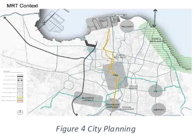
Future planning of Surabaya to be better liveable city; friendlier to the pedestrian and encourage people to use public transportation instead of using their own. In order to achieve it, one of the plans are to create TOD (Transit Oriented Development).
TOD is the functional integration of land use and transit through the creation
of compact, walk able, mixed use communities within walking distance of transit corridors or nodes. TOD brings people together, jobs, and services and is designed in a way that makes it efficient, safe, convenient and attractive to travel in public transport in a sustainable way.
Figure 4 City Planning
I.3 Design Criteria
o The building should allow function
flexibilities, to let visitors self-interpret the meaning of space.
o Less furniture, clearer space
Figure 5 Less Furniture
(Source: Self Analysis)
o Interior must be moveable
Figure 6 Moveable Cart
(Source: Self Analysis)
o The building should be able to provide
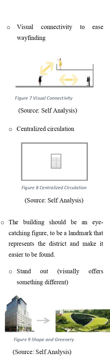
clear direction of circulation, to reduce the risk of overlapping and confusion.
o Visual connectivity to ease
wayfinding
Figure 7 Visual Connectivity
(Source: Self Analysis)
o Centralized circulation
Figure 8 Centralized Circulation
(Source: Self Analysis)
o The building should be an
eye-catching figure, to be a landmark that represents the district and make it easier to be found.
o Stand out (visually offers
something different)
Figure 9 Shape and Greenery
CHAPTER II
PROGRAMMING
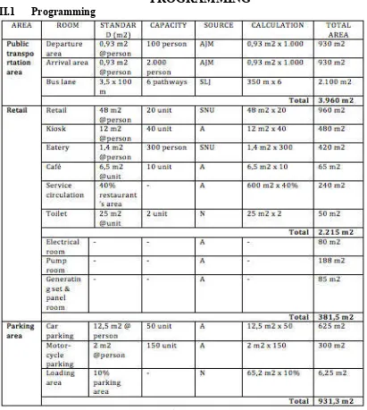
II.1 ProgrammingTable 1. Programming
Notes:
• N : Neufert Architect Data
• SNU : Standard for New Urban
• SMPD : David Man, Shop a Manual of Planning and Design
• AJM : AJ Metric
• SLJ : Standarisasi Lintas Jalan dan Rel
• TSS : Time Saver Standard
II.2 Site Description
Lahan berlokasi di wonokromo. Surabaya dengan luas 16.658 m2 . dengan KDB 75% dan KLb 450%. Dengan garis sempadan sisi utara dan timur sebesar 8 meter. Dan di sisi selatan sebesar 6 meter dan disisi timur sebesar 20 meter.
Figure 10 Proposed MRT Location
(Source: Confererence World Bank)
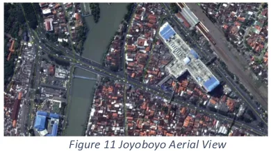
There will be 5 proposed sites for the MRT corridor; Jembatan Merah, Tunjungan, Keputran, Joyoboyo and Mayjen Sungkono. The sites were chosen as a representation of different urban conditions as they occur along the MRT corridor. The site chosen is the one in Joyoboyo. The proposed building will be built at Joyoboyo Terminal, with total area of 1,2 Ha which is strategically located between Jl Joyoboyo and Jl Wonokromo.
Figure 11 Joyoboyo Aerial View
(Source: Conference World Bank)
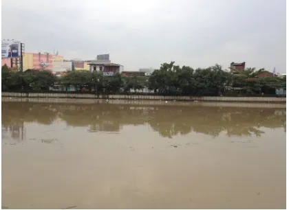
Figure 12 Inside Joyoboyo
(Source: Conference World Bank)
Figure 13 Joyoboyo Site View Figure 14 Joyoboyo Front View
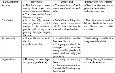
PARAMETER POTENCY PROBLEM PROPOSED SOLUTION Activity - The buildings / areas
nearby have their own activity, each are different - The areas nearby have their own program
- The peak hours of each areas are closed to each other
- Clear direction on how to get to the destination - Alternative access
Circulation - It is basically located near a junction, which means it is somehow people will always be passing through despite the time
- Each of the buildings has their own circulation which some time may be crossed with each other
- The circulation should be defined clearly so that it will not disturb each other activities
Accessibility - One of the entrances to the city
- Easily accessible
- Located a bit far from the business district
- The program should be arranged attractive enough so that people will come, and not only just passing by
- The building should be able to represent the district
Segmentation - Diversity on user (age, and the placement of it
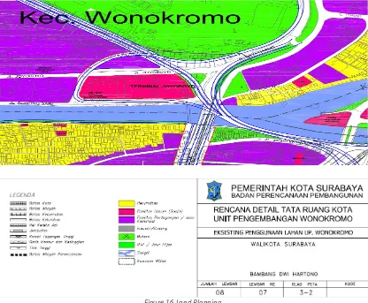
Based on RTRW (Urban Land Use Plan) Surabaya 2013, Surabaya will be divided into 12 development units. Joyoboyo is located in Development Unit 7 Wonokromo, which will be aiming to accommodate main activities like housing and trading, with the growth points of trade and services along Wonokromo Road corridor.
As stated above, the site is located at Jl Joyoboyo, which is supposed to be public facility. While the
site is surrounded by commercial buildings, there are also housing area but located a bit far from the site proposed. The area around site used to be for housing, but now it is planned to be trading and commercial service area. There is not much open space other than the zoo since the road around site is already full with buildings. Later, the site will be more crowded since it is planned to be main artery road.
Figure 16 Land Planning
Figure 17 Street Development
SITE ORIENTATION
NEARBY BUILDING
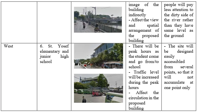
DOCUMENTATION SIDE EFFECT SOLUTION
North 1. Small kiosk park according to their own needs, less considerate towards others
- The
infrastructure is already prepared, as we can see in the pedestrian way, sadly there is not much people walking around - Some people
see the
pedestrian way as their ‘rest area’
- Affect the view and spatial arrangement of the proposed building
- To give a higher degree of enclosure
provided on the ground level so that people will be encourage to walk around of the building
- The building is arrangement of the proposed building
- Consideration towards the accordance to the existing the view directly and affect the
image of the building indirectly - Affect the view and spatial arrangement of the proposed building
people will pay less attention to the dirty side of
elementary and junior high school
- There will be peak hours as the student come and go from/to school
- Traffic level will be increased during the peak hours
- Affect the circulation in the proposed
accumulate at one point only
CHAPTER III
DESIGN APPROACH & METHOD
III.1 Design ApproachUnvolumetric Architecture talks about how a person perceives a space. Basically, Unvolumetric Architecture is trying to accommodate several activities in the same space without
Figure 19 Unvolumetric
(Source:Contemporary Public Space:
Aldo Aymonino)
III.2 Design Method
The building will accommodate several functions with the terminal and/or station as the main function. There will be some several supporting functions as the building is planned to support the transit oriented development planning and also to be the hub representing the district.
Based on the unvolumetric architecture, one of the points is exploring
spatial characteristics based on the
location, to define functions
Analysis of nearby area
Figure 20 Analysis of Nearby Area
Activity analysis
One of the next things to do is analyze the terminal users and their movement to decide on the circulation. There are two terminal users, the person (commuters, traders, visitors and management) and the vehicle (tourism bus, feeder, trunk, private car, motor and bike).
Analysis to define what passenger does when they are inside the terminal.
a. Passenger comes to the terminal - going to the departure platform – waiting before departure – depart to their destination.
Dropped off – waiting – depart c. Arrival
Dropped off – passenger going to another transportation modes or to their private vehicle – depart
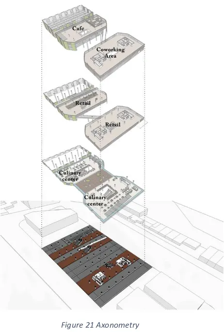
Programming
Programs arrangements are based on observation on users’ economy level to suit people around the site, the higher the level, the more exclusive it will be. Flexibility is conceived as the creation of generic floors. Programs are not separated, rooms or individual space also not given unique characters.
Figure 21 Axonometry
CHAPTER IV
DESIGN CONCEPT
IV.1 Formal ExplorationFigure 22 Site Planning
(Source:Pemkot)
The hub acts as linkage & meeting point between the nearby area, tram station and the intermodal transportation inside to increase connectivity between the districts.
Figure 23 Idea Exploration
(Source:Self Analysis)
On the outer side of the building there is outdoor ramps to offer different way to circulate around the building and to strengthen the concept itself, as the ramps are interconnected through the building with one and another.
Figure 25 Shape & Form Idea
1. Traffic circulation
2. Affects point of view people nearby, how people see the
building (direction)
3. Optimum space taken from point of view
4. Mass divided into two, because according to the plan, there are 2 main functions of the building; intermodal terminal and parking lot 5. Interconnected seen as infinity
shape
6. Adaptation to the building
Figure 27 Vehicle Direction
CHAPTER V
DESIGN
V.1 Formal ExplorationFigure 30 Fourth Floor Plan
Figure 32 Second Floor Plan
Figure 34 Perspective Interior (2)
Figure 36 Section (1)
Figure 38 (Section 3)
V.2 Technical Exploration
CHAPTER VI
CONCLUSION
REFERENCES
[1] Benham, R., ‘Environmental Management’ In: ‘Space Reader’ – Heterogeneous Space in Architecture, edited by Hensel, Michael, Hight, Christopher., 2003 [2] Clinton Cole, ‘Wall-less’ Architecture – Towards a Renewed Perception of
Boundary and Space, 2012
[3] Lawson, B., The Language of Space; Architectural Press, 2001
[4] Hansen Partnership and SUTD CITY FORM LAB, Program Pembangunan Koridor Kota Surabaya – Laporan Akhir. Surabaya (2014)
[5] Pemerintah Kota Surabaya, Perencanaan Kawasan Pasar Wonokromo Surabaya. Surabaya (2016)
[6] Pemerintah Kota Surabaya, Perda Tata Ruang dan Wilayah Kota Surabaya Tahun 2014 – 2034. Surabaya. (2014)
[7] Pemerintah Kota Surabaya, Peta RDTRK Surabaya, kecenderungan orientasi Perdagangan UP Wonokromo. Surabaya. (2007)
[8] Pemerintah Kota Surabaya, Peta RDTRK Surabaya, Peta Rencana Tata guna Lahan Kawasan Wonokromo. Surabaya. (2007)