VALUE ADDITION TO CARTOSAT-I IMAGERY
Murali Mohan
Mobiterra Solutions (India) Private Limited, India [email protected]; [email protected]
Commission VI, WG VI/4
KEY WORDS: RPCs, Block adjustment, stereo, imaging satellite, Cartosat-I, orthoimage, registration
ABSTRACT:
In the sector of remote sensing applications, the use of stereo data is on the steady rise. An attempt is hereby made to develop a software suite specifically for exploitation of Cartosat-I data. A few algorithms to enhance the quality of basic Cartosat-I products will be presented. The algorithms heavily exploit the Rational Function Coefficients (RPCs) that are associated with the image. The algorithms include improving the geometric positioning through Bundle Block Adjustment and producing refined RPCs; generating portable stereo views using raw / refined RPCs autonomously; orthorectification and mosaicing; registering a monoscopic image rapidly with a single seed point. The outputs of these modules (including the refined RPCs) are in standard formats for further exploitation in 3rd party software. The design focus has been on minimizing the user-interaction and to customize heavily to suit the Indian context. The core libraries are in C/C++ and some of the applications come with user-friendly GUI. Further customization to suit a specific workflow is feasible as the requisite photogrammetric tools are in place and are continuously upgraded. The paper discusses the algorithms and the design considerations of developing the tools. The value-added products so produced using these tools will also be presented.
1. INTRODUCTION 1.1 The satellite
Cartosat-I, of 2005 vintage, continues to beam stereo pairs from its twin cameras at a ground pixel resolution better than 2.5m: one component near-nadir-looking and the other oblique-looking. A stereo pair sweeps ground area of 800 sq. km. nearly. The two stereo components, intuitively labelled AFT and FORE images to indicate the look direction, are designed to produce Digital Elevation Models (DEMs) highly amenable to auto-correlation - possible due to near-simultaneous imaging. The data from on-board instruments like GPS and improvised star sensor are used to generate terrain-independent Rational Function Model.
1.2 RPC characteristics
Rational Function Coefficients (RPCs), bundled with GeoTiff images by the data provider, enable two-way relation between the image and object spaces, obviating the knowledge of the imaging system. Such vendor-side RPCs are sensor-derived and terrain-independent. A sparse but nation-wide control point library aids in producing quality RPCs which produce parallax-free stereo models. However, they require refinement at scene/block level for attaining mapping accuracy by introducing GCPs by the end-user (Sadasiva Rao etal, 2006) The model adapted in this exercise is categorized as “terrain-dependent model scenario; user-side RPC refinement”. For comprehensive treatment on this topic (Tao and Hu, 2001) may be referred. The salient behaviour of RPCs is discussed by Fraser and Hanley (2003).
The photogrammetric systems do carry out the required refinement through Block Adjustment and then generally
encapsulate the refined RPCs in proprietary formats, thus preventing their direct interoperability across the systems. The observation equations are of the following form:
where (row, column) = the image-space coordinates (X, Y, Z) = the ground-space coordinates (a, b, c)s = the coefficients (RPCs)
Further mathematical treatment can be found in Grodecki and Dial,(2001) and Fraser etal (2006). The subtle distinction between the types of RPCs is described in the following sub-sections.
1.2.1 Vendor-side RPCs
The vendor of the imagery (e.g., ISRO for Cartosat-I) has access to the physical parameters of the sensor. The RPCs so generated using sparse GCPs are largely terrain-independent. Rational Function Model, provided in the form of Orthokit by NRSC Data Centre (NDC) is considered here as the base input – amenable for value-addition.
1.2.2 User-side RPCs
When the end-user procures imagery along with RPCs (produced by the vendor as described above), it is required to further refine the RPCs with the GCPs through the photogrammetric process of Block Adjustment. Using the refined RPCs, the forward processing for stereo-compilation, DEM generation and ortho-rectification can be taken up. The
(1) The International Archives of the Photogrammetry, Remote Sensing and Spatial Information Sciences, Volume XL-8, 2014
ISPRS Technical Commission VIII Symposium, 09 – 12 December 2014, Hyderabad, India
This contribution has been peer-reviewed.
appendix lists a sample of vendor-side and user-side RPCs for photogrammetric tools exclusively for satellite stereo processing. Where possible inbuilt linkages are provided through organised reference data (such as gratis DEMs, map grids). RPCs are extensively used as the principal sensor model – considering its popular use and generality. Where RPC formats are differently packaged from Ikonos / Cartosat format, suitable parsers are developed (e.g., Pleiades, WorldView).
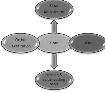
Figure 1. The scope of the library design
The following stand-alone modules have so far been developed and tested for the targeted usage:
Name of the module Brief functionality TerraBlock
RectiFire TiffTiler
Portable Stereo Tool
Block adjustment of stereo pairs and producing open-formatted refined user-side RPCs
Ortho-rectification and mosaicing Slicing based on SoI map index Anaglyph generation using raw or refined RPCs
EasyReg Image registration with one seed point
Table 1. Developed and tested modules
2.2 TerraBlock: Block Adjustment
The scope of the module is to allow the user to mark the control and tie points and then perform the bundle block adjustment. window. The control points are input in ESRI Shape file format. Upon selecting a point for marking, the software guesses the
images likely to contain the point and focuses to the approximate location within the image, aiding the user to complete the task of measurements faster. The principal functions of the module are tabulated below:
Ground to Image Function [To find image coordinates for the given ground coordinates.]
RFMApply_G2I( long, lat, height, scan, pixel );
RFMApply_I2G( scan, pixel, height, long, lat );
RFM Free_Intersection(); Or,
RFMIntersection( tie-points file, lat-long-height file);
RFMdoBundleAdjust (variable); Variable =0 for Bias corrections =1 for Affine corrections
RFMApply_G2I(long, lat, scanline, pixel); //Apply corrected RPCs
RFMCheck_RPC() ; Delete RFM;
Table 2. Principal components of the photogrammetric core library
The module has been tested with the stereo data of Cartosat-I and GeoEye (Murali Mohan, 2011). Add-on functionalities for handling WorldView stereo and Pleiades triplet are being developed.
Figure 2. The stereo pairs of Cartosat-I used for testing the accuracy
The module computes the refined RPCs and writes them as text files – enabling their exploitation in other photogrammetric software for the tasks like DEM extraction The International Archives of the Photogrammetry, Remote Sensing and Spatial Information Sciences, Volume XL-8, 2014
ISPRS Technical Commission VIII Symposium, 09 – 12 December 2014, Hyderabad, India
This contribution has been peer-reviewed.
and feature coding. The appendix lists the raw and refined RPCs to demonstrate this compatibility. The module comes with ease-of-use GUI that enables manual marking of control and tie points. Control requirement is one common point for four stereo models.
In the use-case of 7 stereo models of Cartosat, wherein 9 GCPs are used and the accuracy is checked at 132 check points. The errors at control points are 0.8, 0.5 and 1.3m in XYZ respectively; and at the check points the RMS in XY is 2.6m and RMS in Z is 3.1m. These are in-tune with the benchmarking findings (Sadasiva Rao etal, 2006).
2.3 RectiFire: Orthorectification and mosaicing
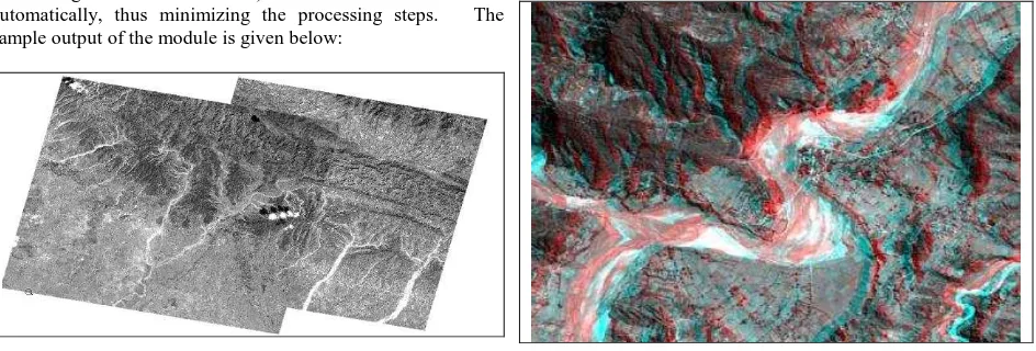
A logical follow-up operation after refining the RPCs is to ortho-rectify the image(s) so desired. RectiFire is a standalone module which processes individual scenes and a seamless mosaic is generated with a preview option. The module extracts the corresponding DEM from the linked data repository (containing SRTM and ASTER) for the extent of the scene automatically, thus minimizing the processing steps. The sample output of the module is given below:
Figure 3. The mosaic of ortho images resulting from adjacent paths of the satellite
In addition, provisions for constant elevation based correction for flat areas and user-provided DEM are built-in. The most commonly used resampling options are incorporated. The output bit-depth can be 8/16 bits. The geographic framework is WGS84.
2.4 TiffTiler: Ortho-slicing based on national map grid Further, user can slice the orthoimages based on Survey of India (SoI) map index at 1: 25000 scale. The index-grid is built-in and hence the operation avoids user-inputs. TiffTiler identifies the partial orthos resulting from overlapping orthos and mosaics them automatically where possible. The module handles 8/16/24-bit GeoTiff. A cut-off threshold of minimum 10% image data per map sheet eliminates sliver tiles.
2.5 Portable Stereo Tool: Anaglyph generation
This is an innovative tool towards value-addition. Making use of the raw or refined RPCs, the tool carries out the Epipolar registration of the stereo-pair and generates the anaglyph on-the-fly. The output is printable after the map-composition. The process does not require DEM or DTM – thus obviating the limitation of the subtle terrain-defining details such as troughs and tops being missed out due to coarse cell-spacing.
The tool handles the NRSC-supported stereo pairs or custom-generated long strips. Multiple options for choosing the area of interest are incorporated such as SoI map sheet extents, point-radius, bounding box, or complete model.
Figure 4. The orthoimage being sliced as per the Survey of India map extent definition/
Figure 5. The anaglyph generated from a stereo pairs of Cartosat-I with raw RPCs. (To appreciate the depth, the Red-Cyan filters are to be used as eye-wear.)
The anaglyphs can be inserted into project reports for enhanced terrain appreciation. When carried to the field, the output aids in authentic correlation with the terrain the user is standing on. 2.6 EasyReg: Image Registration made easy
This is a standalone tool to quickly register Cartosat I and II satellite imagery by exploiting the associated raw RPCs. The salient feature is the requirement of minimal user-interaction - limited to adding one seed point. The tool comes embedded with the reference datasets-to collect the seed point; and later to do the quality check. The built-in functions such as horizontal and vertical swiping aid the checking process. The whole exercise of registration is designed in such a way that it seldom exceeds 10 minutes of elapsed time (excluding the raw image ingest time). This approach is preferred when the user is required to geometrically rectify a single image without going through the conventional photogrammetric process.
3. CONCLUSIONS
The set of photogrammetric tools for value-addition to satellite stereo imagery has been presented. The design aspects and sample results of block adjustment, ortho-rectification, portable stereo generation and image registration are discussed. The The International Archives of the Photogrammetry, Remote Sensing and Spatial Information Sciences, Volume XL-8, 2014
ISPRS Technical Commission VIII Symposium, 09 – 12 December 2014, Hyderabad, India
This contribution has been peer-reviewed.
outputs of these modules are interoperable with commercial photogrammetric systems and open GIS packages. The modules have been tested successfully and the results are commensurate with the mission capabilities of Cartosat-I.
The refined RPCs written in open format offers great flexibility to perform tasks in preferred systems by the end-user. They enable DEM and stereo-compilation directly.
REFERENCES
Cartosat-1 (IRS-P5) Data Products Generation Station: DDR Document. Signal and Image Processing Group, Space Applications Centre, Ahmedabad, April 2004
Fraser, C., Dial, G., Grodecki, J., 2006. Sensor orientation via RPCs. ISPRS Journal of Photogrammetry & Remote Sensing 60(3): 182-194.
Fraser, C. S., H. B. Hanley, 2003. Bias compensation in rational functions for Ikonos satellite imagery.
Photogrammetric Engineering and Remote Sensing, 69(1): pp. 53-57.
Grodecki, J., and Dial, G., 2001, IKONOS Geometric Accuracy, Proceedings of Joint ISPRS Workshop on High Resolution Mapping from space, 19-21 September, pp. 77-86
Murali Mohan ASRKV., Block Adjustment of Cartosat-I Stereo Data Using RPCs, Geospatial World Forum, 2011.
Sadasiva Rao, B., Murali Mohan ASRKV., Kalyanaraman, K., Radhakrishnan, K. Evaluation of Cartosat-I Stereo Data of Rome, 2006, International Archives of Photogrammetry, Remote Sensing and Spatial Information Sciences, Vol. 36, Part 4, on CD-ROM. Also in Vol. XXXVI, Part-IVB, pp. 1026-1029.
Tao, C. V., Y. Hu , 2001. A comprehensive study on the rational function model for photogrammetric processing. Photogrammetric Engineering and Remote Sensing, 67(12): pp. 1347-1357.
APPENDIX
Header part of RPC file as provided by NRSC for P508-R248 Aft image (Vendor-side RPCs)
Corresponding part of TerraBlock-generated RPCs (User-side RPCs)
The International Archives of the Photogrammetry, Remote Sensing and Spatial Information Sciences, Volume XL-8, 2014 ISPRS Technical Commission VIII Symposium, 09 – 12 December 2014, Hyderabad, India
This contribution has been peer-reviewed.