RETHINKING OF LYNCH’S: A STUDY OF YOUNG PEOPLE’S
PERCEPTION OF SURABAYA CITY
DAMAYANTI, Rully
Architecture Department, Faculty of Civil Engineering and Planning Petra Christian University, Surabaya – INDONESIA
Email: [email protected]
KOSSAK, Florian
School of Architecture, The University of Sheffield – Sheffield, UK Email: [email protected]
ABSTRACT
Kevin Lynch’s concept of the image of the city has influenced many academics and practitioners around the world.
However, misconceptions have arisen in applying Lynch’s concept through a superficial understanding of his five elements.
The main purpose of this article is to extend meaning making behind the urban elements identification, on which Lynch had put less emphasizes. The research, on which this article is based, has been conducted in Surabaya- Indonesia with young people from a mid to high economic family background that a have high dependency on private cars. In imagining the city, they emphasize more on meaning rather than physical appearances of the elements. Meaning is driven by their daily route, social life style, and ethnic background. Lynch identified three dimensions in imagining cities, namely identity, structure and meaning, which are embedded in the urban elements. In this case study, meaning is regarded as being more important than the other two and as it represents social symbols of a specific group in the city of Surabaya.
Keywords: Perception, city image, urban elements.
INTRODUCTION
Published in 1960, Kevin Lynch’s book ‘Image
of The City’ highlighted particular urban elements
that would help people to create a sense of the place of navigation in an urban context. He identified five urban elements that were defined through an explo-ration of human orientational behavior in three cities: Boston, New Jersey and Los Angeles (Lynch, 1960).
Lynch’s concept has influenced many academics and
practitioners around the world, both urban designers
and architects. Lynch’s research focused on urban
elements as products of environmental image or perception, which is ideally understood through
analysis of a city’s identity, structure and meaning.
However, misconceptions have arisen in applying
Lynch’s concept through a superficial understanding of his five elements, focusing only on the ‘Image of
The City' in regard of observing structure and identity, neglecting meaning behind this understanding. Lynch apparently put less emphasis on the category that most people believe is the most relative and uncertain factor, because of its social and cultural aspects.
This paper is based on a research project that was undertaken in Surabaya-Indonesia with partici-pants of a specific group of young people. Applying
Lynch’s concept of the five elements, the purpose of
the research has been to identify urban elements that are perceived to this group in order to identify social symbols as representational social value of them. The research established the significant reasons behind the
elements’ identification, in terms of their structure,
identity and meaning. There are two components of research methods used in this study: mental map
drawings (as in Lynch’s concept), followed by
semi-structured interviews and group discussions. The young people were asked to imagine their city through mental maps and were also interviewed in order to understand the reasons behind their choice of elements and route in the maps.
THEORETICAL BACKGROUND: LYNCH’S
CONCEPT
According to von Meiss (1986), people have an ability to perceive their environment through their memory. This ability connects humans to their
environment and identifies as human’s ability to
situate and navigate him/her in the setting (Gibson, 1950). Perception is a mental representation of spatial knowledge, which in psychology terms, perception is
very much affected by people’s feeling towards a
Lynch identified the five urban elements that help the observer to navigate in an urban context as: path, nodes, landmark, district and edges. He stated that the image/ perception of the city is needed not only to human navigation (way finding) but also to give emotional security and define a social role in the urban context. Lynch believed that the five elements are the most legible elements in the urban context. He stated that legibility is the most crucial thing in city settings, not in terms of the city itself but how its inhabitants perceive the city. There is a dialog between the observer and the environment that is analyzed into three aspects: identity, structure, and meaning (Lynch, 1960). Identity and structure are the most legible/visible aspects of physical elements in cities, while meaning is very relative in regard to different cultures.
In the ‘Image of The City’, Lynch focused his research primarily on ‘identity’ and ‘structure’. He put
less emphasis on the aspect that is the most relative
and uncertain: ‘meaning’, because of its social and
cultural context. However, in his later books, Lynch put more emphasis on social, cultural and historical background of the observers and the city (Lynch, 1990). He also asserts that meaning is developed by
character/ quality of the elements and human’s
cities. Each region or district has a specific meaning to its inhabitant, related to use, function and symbols (Lynch, 1982). The age of the observer is also an important factor to be considered in developing meaning (Lynch, 1977). He further stated that the history of a city creates specificity that could be defined as a character of the city (Lynch, 1982). He put emphasis on sense of place as parts of creating a good city (Lynch, 1981). After his death, Banerjee and Southworth compiled his papers and writings, which were unpublished before. In one of these papers, Lynch mentioned place attachment as one of important factors of human satisfaction of living in cities (Lynch, 1990).
In short, Lynch (from 1960 to 1990) has defined two important aspects in reading cities: physical and social aspects. The physical aspects are represented through legibility of the five urban elements, while the social aspects are developed by people’s experience and background. However, misconceptions have
arisen in applying Lynch’s theory through a
superficial understanding of his five elements,
focusing only on the ‘Image of The City' in ‘structure’ and ‘identity’ observations.
This suggest that while Lynch has over the years extended and shifted his theories towards a more social and cultural understanding of space, including making of meaning as a crucial factor in constructing
the ‘Image of the City’, the perception and application
of his theories remained somewhat limited. While it is goes beyond the scope of this particular study to explore the reasons of this reduced perception, the study takes this extended position by Lynch into account and explores the potential that this has for understanding the perception of cities through its inhabitants.
THE RESEARCH METHODS AND PARTICIPANTS
The purpose of the research is to identify urban elements that are perceived by a specific group of
young adults, by applying Lynch’s concept, and
identifying the significant reasons behind the elements identification, in terms of their structure, identity and meaning. The research deployed to main methods: a) mental map drawing which were followed by b) semi-structured interviews and group discussions. The applied methods are adopted from Lynch in observing image of cities through elements identification.
The participants were asked to imagine their city through drawing mental maps. From the individual mental maps, combined a mental map has been produced by categorizing the identified urban elements into five elements of Lynch theoretical concept. The process of producing the combined map is based on quantitative analysis of the individual mental maps. The participants were also interviewed in order to understand the reasons behind their choice of elements and route in the maps. Through discussions on drawn city maps, participants were asked to identify the elements in the city that are important for them in their daily navigation.
Participants of this research were 80 students from the Architecture Department at Petra Christian University, Surabaya-Indonesia, aged of 20 to 23 years. Most of them live in the Western, more affluent, part of the city. The young people in the group are very much exposed to urban traffic and mobility. They also mainly experience very specific building typologies such as malls, related to their lifestyle.
IMAGE AND PERCEPTION OF SURABAYA CITY
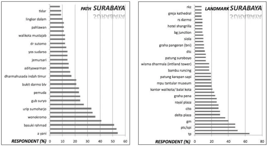
identified by the participant. Names and numbers of the landmarks and paths mentioned and noted by the participants in the mental map could be seen on the Table 1 below.
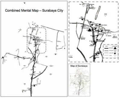
A mental map of the city was developed based on a compilation of the individual mental maps; the darker the path on the map, the more frequently participants mentioned the path; the bigger and the darker the landmark icon, the more frequently participant mentioned the landmark on their mental map; as seen in the figure below.
From the city mental map above, the three most frequently mentioned landmarks are commercial buildings Tunjungan Plaza (TP), Pakuwon Trade Centre (PTC), and Galaxy Mall (GM), followed by some office buildings such as Kantor Walikota and
Wisma Dharmala. The identification of these
land-marks appears more often than the city’s conventional
landmarks; such as Karapan Sapi Statue, Bambu Runcing Statue, and Suroboyo Statue. Paths noted focused on the main street/artery of the city. The young people perceived to a lesser extend areas outside the main street. Some of them noted elements in the central city area without connecting the path from the main street.
In the group discussion, the participants were asked to describe the most important elements of the city to be remembered by the young people in terms of daily navigation. Eight elements are identified; five elements are related to permanency, and the other three are temporary, both in terms of location and time. The elements are mentioned below, number 1 to
5 indicate the permanent elements, the rest are temporary elements.
1. Abandoned historical buildings: these are histo-rical, previously famous buildings in Surabaya that are currently empty and or in the process of becoming abandoned, however the buildings provide today still a significant preference of navigation.
2. Informal business districts: are locations of infor-mal business activities in particular areas provided
by Surabaya’s government.
3. Building-brand as landmark: brand or name of the building is more familiar rather than its physical appearances.
4. Characterized neighbourhood gates: since closed cluster for residential estates became familiar in Surabaya, and recognition of the estates is through
its gate, most people recognized gate’s specific
design as element of navigation.
5. Formal business districts (for specific products): particular areas are given by the government to small businesses retail to open their shops with similar goods of selling.
6. Traffic-jam locations: heavy traffic jam is regu-larly occurred on some streets in Surabaya, the condition is recognized as one of important condition in navigation.
7. Temporary informal business activity: location of informal business activity along particular road, which is open in particular time and day (for street vendor and hawkers).
8. Street-crime location: street crimes mostly occurred in some major paths in Surabaya, and becomes important condition mentioned in daily navigation.
SURABAYA’S PERCEPTION
From the combined mental map of the city, one can see an accumulation of mentioned landmarks clustered in the city center as well as further down towards the south. The young people of this group are more familiar with malls, especially Tunjungan Plaza
(TP), Supermall (SPI), and Galaxy Mall (GM), rather than city monuments such as Karapan Sapi Statue,
Bambu Runcing Statue, and Suroboyo Statue. The participants use these landmark of malls to orient
themselves in city’s setting, mostly because they have
more meaning and connection with these malls and offices related to their daily activity. Official monu-ments or statues that are known and mentioned, are mentioned not because of their inherent symbolic meaning but because of their specific location, for instance the junction of main-streets and inside strong nodes of the city center that may act as meeting points.
Referring to the Surabaya mental map, partici-pants clearly imagined the main street of the city. Some streets on the east to west, and in the northeast
Figure 1. Combined Mental Map
of the city, also got the significant representation on the map. Streets that are the most legible on the map are the streets where the most landmarks are mentioned. However, in the north and northeast,
participants could identify landmarks, ye couldn’t
clearly imagine the paths. The urban element of the path is very much related to the daily routes of the participants, as well as to their knowledge of particular landmark in the city. For example, they know that Tanjung Perak is on the north (it is the only port in the city, and major port in East Java Province with strong history during colonization era), but they cannot represent the route, similarly to Kenjeran Park
(the famous seashore theme park) to which they could not identify the route.
Figure 3. The main street of Surabaya city
Three groups (out of eight groups) of partici-pants, mention negative words while asking to describe the most important condition of Surabaya city to be remembered by the inhabitant in navigation: historical-abandoned buildings, street crime, and traffic jam location. The participant said that knowing the locations of street crime (mostly occurred), the locations of temporary informal business activity (mostly creates traffic jam) and the location of streets that are affected by business hours; are very important information to navigate them within Surabaya city. They said, before they start their activity by driving their car, they consider the location of street crime, temporary market, and traffic jam, in order to avoid the location. Scannel (Scannell & Gifford, 2010)
believes that it is part of an individual’s cognition that leads to behavior: the observer indicates a negative cognition of the area which leads to a navigation decision. Cognition is therefore a dimension in place attachment.
Interviews with the participant indicate that the choice of malls in doing their social activities, mainly based on their reference from friends and relatives.
Every ethnic group has their own enclave in the city, as well as choice of malls (Cairns, 2004). For most Chinese family in Surabaya, they like to do their activity in TP, GM and SPI (the three most mentioned landmarks), rather than in other malls. The choice of place is related to group activities as one of dimension of place attachment (Scannell & Gifford, 2010). Experience in place, in this case is malls; regards to individual and group activity related to their history (enclave tendency), which later mall could be describe as social symbol of the group.
CONCLUSION
Summary are drawn from the above explo-ration as follow:
1. The young people strongly perceived the malls in creating the city image, on the other hand the conventional city symbols become less important. 2. The main street of the city is an important element of the young people, since it relates to their daily activity.
3. Overall image of the city mainly determined by the central city, where young people mostly experience urban spaces.
4. In terms of navigation decision, participants recognize both a positive and a negative image of
the city’s environmental condition, equally in
permanent and temporary elements.
5. The preferred malls are social symbols for the young people and are related to their ethnic enclave tendency and the group activity.
In the case study, spatial knowledge of the young people mostly focuses along the main street of the city and the city center; therefore they have a strong perception of these areas. Driven by their lifestyle, they choose malls as places for their social activity.
This will gradually shift the conventional city’s
landmark of its monumental, historical building and important element of urban landscape. They feel attached to the city mostly in these parts, while they understand the importance to know some historical icon of the city without their personal experience. Because of their dependency to private cars, main references to understand the city very much depend on the main street location, and very less of detail of buildings if they have no experience. Landmarks are merely understood because of its power of
partici-pant’s social activity and (cars) navigating.
Perceptions of landmark and path (city structure), which are explained above and represented in the Surabaya mental map, reflect a mental representation
The knowledge is built when the participant connects with the place and interacts in the place by doing their social activity (Tuan, 1977) (Canter, 1977). Hence the perception of the inner city is stronger as the perception and attachment to its urban elements is also stronger, whereas this perception reduces in areas with weaker attachment to elements and reduced social activity. The two types of landmark identification (landmark with and without connected path/route) show that the way of the participants understand path is based on their activity (meaning), and also their knowledge (identity and structure). Ethnics background also gives contribution in choosing location of activity, including schools, malls, and markets.
Based on the participant’s preferences in
navigation, half of them show negative image of the city. The participant put emphasis in historical buildings but abandoned (for many reasons) rather than that beautiful buildings. Traffic-jam and street crime locations are also important, rather than remembering the good quality of the street, nodes or its meaning; and also temporary traditional market is also seen as a cause of traffic jam. The observers through their positive or negative, strong or weak perception of the city define the degree of attachment;
while the perception is build from observer’s
experience in the social interaction in the physical container of the city.
As conclusion, in imagining the city, the young people emphasize more in meaning rather than physical appearances of the elements. The meaning is driven by their daily route, lifestyle, and ethnic background. Based on Lynch’s concept; spatial knowledge and perception that are identified through the mental map, together will develop the vitality, senses, fit, access, and control; through pattern of sensory stimulation, area of vital and behavioral
activity, and area of interpersonal relation. Lynch identified three dimensions in imagining cities, namely identity, structure and meaning, which are embedded in the urban elements. In this case study, meaning is regarded as being more important than the other two and as it represents social symbols of a specific group in the city of Surabaya.
REFERENCES
Cairns, S. (2004). Drifting: Architecture/ Migrancy. In S. Cairns (Ed.), Drifting: Architecture and Migrancy. New York: Routledge.
Canter, D. (1977). The Psychology of Place. London: The Architectural Press Ltd.
Gibson, J. (1950). The Perception of The Visual WOrld. Westport: Greenwood Press Publisher. Lynch, K. (1960). The Image of The City. Cambridge:
The MIT Press.
Lynch, K. (1977). Growing Up in Cities: studies in the spatial environment of adolescent. Cam-bridge Paris: MIT Press UNESCO.
Lynch, K. (1981). Theory of Good City Form. Cam-bridge: The MIT Press.
Lynch, K. (1982). What Time Is This Place? Cam-bridge: The MIT Press.
Lynch, K. (1990). City Sense and City Design: writings and projects of Kevin Lynch. (T. Baner-jee & M. Southworth, Eds.). Cambridge: The MIT Press.
Scannell, L., & Gifford, R. (2010). Defining Place Attachment: A Tripartite Organizing Frame-work. Journal of Environmental Psychology, 30, 1–10.
Tuan, Y. F. (1977). Space and Place: The Perspective and Experience. London: Edward Arnold. Von Meiss, P. (1986). Elements of Architecture. New