Publication Date: 2013-06-18
Approval Date: 2013-04-23
External identifier of this OGC® document: http://www.opengis.net/doc/bp/Name-type-crs
Reference number of this Document: OGC 11-135r2
Version:1.0
Category: OGC® Best Practice
Editor: Peter Baumann
OGC® Name Type Specification for Coordinate
Reference Systems
Copyright © 2013 Open Geospatial Consortium.
To obtain additional rights of use, visit http://www.opengeospatial.org/legal/.
This document defines an OGC Best Practices on a particular technology or approach related to an OGC standard. This document is not an OGC Standard and may not be referred to as an OGC Standard. This document is subject to change without notice. This document is an official position of the OGC membership on this particular technology topic.
Document type: OGC Best Practice Document subtype: Name Type Definition Document stage: Final
OGC 11-135r2
ii Copyright © 2013 Open Geospatial Consortium.
License Agreement
Permission is hereby granted by the Open Geospatial Consortium, ("Licensor"), free of charge and subject to the terms set forth below, to any person obtaining a copy of this Intellectual Property and any associated documentation, to deal in the Intellectual Property without restriction (except as set forth below), including without limitation the rights to implement, use, copy, modify, merge, publish, distribute, and/or sublicense copies of the Intellectual Property, and to permit persons to whom the Intellectual Property is furnished to do so, provided that all copyright notices on the intellectual property are retained intact and that each person to whom the Intellectual Property is furnished agrees to the terms of this Agreement.
If you modify the Intellectual Property, all copies of the modified Intellectual Property must include, in addition to the above copyright notice, a notice that the Intellectual Property includes modifications that have not been approved or adopted by LICENSOR.
THIS LICENSE IS A COPYRIGHT LICENSE ONLY, AND DOES NOT CONVEY ANY RIGHTS UNDER ANY PATENTS THAT MAY BE IN FORCE ANYWHERE IN THE WORLD.
THE INTELLECTUAL PROPERTY IS PROVIDED "AS IS", WITHOUT WARRANTY OF ANY KIND, EXPRESS OR IMPLIED, INCLUDING BUT NOT LIMITED TO THE WARRANTIES OF MERCHANTABILITY, FITNESS FOR A PARTICULAR PURPOSE, AND NONINFRINGEMENT OF THIRD PARTY RIGHTS. THE COPYRIGHT HOLDER OR HOLDERS INCLUDED IN THIS NOTICE DO NOT WARRANT THAT THE FUNCTIONS CONTAINED IN THE INTELLECTUAL PROPERTY WILL MEET YOUR REQUIREMENTS OR THAT THE OPERATION OF THE INTELLECTUAL PROPERTY WILL BE
UNINTERRUPTED OR ERROR FREE. ANY USE OF THE INTELLECTUAL PROPERTY SHALL BE MADE ENTIRELY AT THE USER’S OWN RISK. IN NO EVENT SHALL THE COPYRIGHT HOLDER OR ANY CONTRIBUTOR OF
INTELLECTUAL PROPERTY RIGHTS TO THE INTELLECTUAL PROPERTY BE LIABLE FOR ANY CLAIM, OR ANY DIRECT, SPECIAL, INDIRECT OR CONSEQUENTIAL DAMAGES, OR ANY DAMAGES WHATSOEVER RESULTING FROM ANY ALLEGED INFRINGEMENT OR ANY LOSS OF USE, DATA OR PROFITS, WHETHER IN AN ACTION OF CONTRACT, NEGLIGENCE OR UNDER ANY OTHER LEGAL THEORY, ARISING OUT OF OR IN CONNECTION WITH THE IMPLEMENTATION, USE, COMMERCIALIZATION OR PERFORMANCE OF THIS INTELLECTUAL PROPERTY.
This license is effective until terminated. You may terminate it at any time by destroying the Intellectual Property together with all copies in any form. The license will also terminate if you fail to comply with any term or condition of this Agreement. Except as provided in the following sentence, no such termination of this license shall require the termination of any third party end-user sublicense to the Intellectual Property which is in force as of the date of notice of such termination. In addition, should the Intellectual Property, or the operation of the Intellectual Property, infringe, or in LICENSOR’s sole opinion be likely to infringe, any patent, copyright, trademark or other right of a third party, you agree that LICENSOR, in its sole discretion, may terminate this license without any compensation or liability to you, your licensees or any other party. You agree upon termination of any kind to destroy or cause to be destroyed the Intellectual Property together with all copies in any form, whether held by you or by any third party.
iii Copyright © 2013 Open Geospatial Consortium.
Contents
Page
1
Scope ... 1
2
Conformance ... 2
3
Normative references ... 2
3.1
Normative references to OGC documents ... 2
3.2
Normative references external to OGC ... 3
4
Name assignment policy ... 3
6.1
Namespace prefix conventions ... 5
6.2
BNF notation ... 5
7
CRS definition and identifier ... 6
7.1
Overview ... 6
7.3
Syntax ... 6
7.3.1
General CRS Identifier syntax ... 6
OGC 11-135r2
4
Copyright © 2013 Open Geospatial Consortium.
10
Parameterized CRS ... 13
10.1
Overview ... 13
10.2
Syntax ... 13
10.3
Semantics ... 14
Bibliography ... 16
Annex A (non-normative) OGC CRS Name Resolver ... 17
A.1
Implementation and availability ... 17
A.2
Service elements ... 17
A.3
Service URI ... 17
A.4
Service syntax ... 17
A.5
URI Resolution ... 17
A.6
Parameterized CRS definitions ... 18
A.6.1
Overview ... 18
A.6.2
Structure ... 18
A.6.3
Resolution ... 19
A.7
Flattening of CRS definitions ... 20
A.8
CRS equality ... 20
A.9
XQuery ... 21
v Copyright © 2013 Open Geospatial Consortium.
Tables
PageOGC 11-135r2
vi Copyright © 2013 Open Geospatial Consortium.
i. Abstract
This document specifies a Name Type Specification (NTS) for predefined, combined, and parameterized Coordinate Reference System (CRS) definitions. This NTS augments the /def/
namespace with http URI definitions for CRSs. The NTS is based on the Name Type Specification – definitions – part 1 – basic name [OGC 09-048r3] and supersedes OGC document “Definition identifier URNs in OGC namespace” [OGC 07-092r3].
NTSs are maintained by the OGC Naming Authority (OGC-NA).
This document includes one Annex: a user guide to the OGC CRS resolver.
ii. Keywords
The following are keywords to be used by search engines and document catalogues.
Coordinate Reference System, CRS, CRS identifiers, EPSG
iii. Preface
Attention is drawn to the possibility that some of the elements of this document may be the subject of patent rights. The Open Geospatial Consortium shall not be held responsible for identifying any or all such patent rights.
Recipients of this document are requested to submit, with their comments, notification of any relevant patent claims or other intellectual property rights of which they may be aware that might be infringed by any implementation of the standard set forth in this document, and to provide supporting
documentation.
v. Submitting Organizations
The following organizations submitted this Document to the Open Geospatial Consortium Inc. Jacobs University Bremen rasdaman GmbH
vi. Submitters
All questions regarding this submission should be directed to the editor or the submitters:
Name Organization
vii Copyright © 2013 Open Geospatial Consortium.
vii. Future Work
Among the topics for future development are the following items: Eventually move this document to Policy Standard status Extend CRS URLs with CRS concatenation capabilities
Investigate on the need of URL identifiers for Coordinate System, datum, ellipsoid, prime meridian, etc.
1 Copyright © 2013 Open Geospatial Consortium.
OGC® Name Type Specification for Coordinate Reference Systems
1 Scope
This OGC Best Practice document defines a syntax, based on http URIs, for identifying Coordinate Reference Systems (CRSs), including compound and parameterized CRSs. Strings conforming to this syntax are called CRS URIs. The semantics of such definitions is established by the OGC registry service. The specification on hand does not define concrete URIs, it only establishes an URI scheme; definition of CRS URIs based on this scheme, such as temporal CRSs, is done separately within OGC.
As OGC’s mission centers around location-based data and services, practically all OGC
specifications make heavy use of CRSs to relate object locations in space and time to some reference position. A vast amount of different definitions is in practical use, covering horizontal (geodetic) extents, height, and time. New definitions arise, such as in planetary sciences.
For all of these CRSs, a simple, expressive, and http compatible mechanism is required allowing software to create, identify, and understand CRSs and their definitions. This document establishes a convention for naming CRSs within OGC. In particular, the scheme supports the following use cases:
CRSs with a normatively fixed definition are addressable by a unique URI; e.g., the WGS84 CRS can be identified through http://www.opengis.net/def/crs/EPSG/0/4326;
Shorthands are possible for enumerating a family of supported CRSs; for example, a server supporting the complete EPSG list of CRSs should be able to express this with one URI, such as http://www.opengis.net/def/crs/EPSG/0/, rather than having to enumerate the whole list of thousands of CRSs;
Ad-hoc derivations from CRSs are expressible (see, e.g., the WCS Core), such as the result of an x/t slicing through an x/y/t datacube through a WCS or WCPS operation;
Spatio-temporal CRSs can be established by combining existing CRS definitions; for
example, 3-D georeferenced image timeseries can be described through a combination of 2-D WGS84 CRS and some 1-D time CRS.
Coordinate system axes can be referenced using their names as defined in the CRSs on hand, such as latitude, in operations like spatio-temporal subsetting, thereby enabling semantic checks for admissible axis names by services.
OGC 11-135r2
2 Copyright © 2013 Open Geospatial Consortium.
The naming scheme does not prejudicate any particular CRS definitions, but remains open to any kind of CRSs that may appear in future.
The naming scheme does not assume one central CRS resolver but supports any number of independently maintained CRS resolvers.
This CRS URI naming scheme is implemented by the OGC CRS resolver1 since March 2013.
2 Conformance
For the sake of clarity, this document follows the OGC modular specification style; requirements highlighted in grey boxes constitute the normative information. However, as this document is not an OGC standard it does not contain a corresponding Abstract Test Suite (ATS) Annex.
This document establishes one requirements class, crs-nts, of URI http://www.opengis.net/spec/CRS-NTS/1.0/req/crs-nts. The complete specification consists of the document, accessible under this URL, plus the XML Schema available from http://schemas.opengis.net/schemas/crs-nts/.
Standardisation target of all requirements and conformance classes are HTTP URIs.
Requirements defined in this document are relative to http://www.opengis.net/spec/CRS-NTS/1.0/.
3 Normative references
An OGC name may be provided for a definition of a type of object broadly classified as a "concept" or system parameter. The precise scope of definitions that may be identified with OGC Names is provided by the set of items in the register at http://urn.opengis.net/register/OGC-NA/deftype. This Name Type Specification for CRSs is available for download from
http://www.opengeospatial.org/standards/bp/.
The following normative documents contain provisions that, through reference in this text, constitute provisions of this specification. For dated references, subsequent amendments to, or revisions of, any of these publications do not apply. For undated references, the latest edition of the normative
document referred to applies.
3.1 Normative references to OGC documents
OGC 08-015r2, The OpenGIS Abstract Specification, Topic 2: Spatial Referencing by Coordinates, version 4.0.
OGC 09-046r2, OGC Naming Authority - Procedures
OGC 09-048r3, Name type specification – definitions – part 1 – basic name, version 1.1
1
3 Copyright © 2013 Open Geospatial Consortium. OGC 07-036, Geography Markup Language (GML) Encoding Standard, version 3.2.1
OGC 09-110r4, OGC Web Coverage Service 2.0 Interface Standard – Core, version 2.0.
OGC 11-053, OGC Web Coverage Service 2.0 Interface Standard – CRS Extension, version 1.0.
3.2 Normative references external to OGC
[1] ISO 8601:2004(E) Data elements and interchange formats — Information interchange — Representation of dates and time
[2] www.epsg.org
[3] IETF RFC 2396 (August 1998), Uniform Resource Identifiers (URI): Generic Syntax, http://www.ietf.org/rfc/rfc2396.txt
[4] IETF RFC 5234 Augmented BNF for Syntax Specifications: ABNF (2008). http://tools.ietf.org/html/rfc5234
[5] JSR-233 Scripting for the Java Platform. http://jcp.org/aboutJava/communityprocess/final/jsr223/ [6] W3C, XQuery 1.0: An XML Query Language (Second Edition), W3C Recommendation, 14
December 2010. http://www.w3.org/TR/xquery/
4 Name assignment policy
4.1 Document types
The register of document types http://www.opengis.net/register/ogc-na/doc-type is controlled by OGC-NA. Changes to this register (additions, deletions, and supercession) shall be initiated by a submission to the OGC Naming Authority [email protected].
4.2 Document element types
The registers of document element types is controlled by OGC-NA. Changes to this register (additions, deletions, and supercession) shall be by application to [email protected].
The current state of the register of document element types is shown at
http://www.opengis.net/register/ogc-na/doc-element-type
.
4.3 Names
The register of names http://www.opengis.net/register/ogc-na/name is controlled by OGC-NA. Changes to this register (additions, deletions, and supercession) shall be initiated by a submission to the OGC Naming Authority [email protected] .
OGC 11-135r2
4 Copyright © 2013 Open Geospatial Consortium.
5 Terms and definitions
For the purposes of this document, the terms and definitions given in Clause 3 apply and, in addition, the following terms and definitions. An arrow ““ indicates that the term following it is defined else-where in this Clause 5.
5.1 Axis definition
GML fragment whose root is in the substitution group of gml:CoordinateSystemAxis as defined in [OGC 07-036]
5.2 Axis identifier
URI resolving to exactly one well-known Axis definition
5.3 CRS
Coordinate Reference System
5.4 CRS axis
fixed reference line of a CRS identified by its Axis identifier and described in its Axis definition
5.5 CRS definition
GML fragment whose root is in the substitution group of gml:AbstractCRS as defined in [OGC 07-036]
5.6 CRS Identifier
URI resolving to exactly one well-known CRS definition
Note This can be either a CRS in the substitution group of type gml:AbstractCRS or a Parameterized CRS in the substitution group of crsnts:ParameterizedCRS where all parameters are saturated either via values provided in the URI or through default values provided in the Parameterized CRS definition. See Clause 10.
Example The WGS84 CRS has this CRS Identifier registered with OGC: http://www.opengis.net/def/crs/EPSG/0/4326
This is equivalent to:
http://www.opengis.net/def/crs?authority=EPSG&version=0&code4326 See Clause 7 for the syntax and semantics definition.
5.7 Compound CRS
5 Copyright © 2013 Open Geospatial Consortium.
Note Several constraints need to be fulfilled by a compound CRS (which is taken from OGC Abstract Topic 2 [OGC 08-015r2]); however, as the detailed CRS semantics is not a focus of this specification, these constraints are not addressed here.
5.8 Parameterized CRS
CRS boilerplate which, when provided with concrete values for all its formal parameters, resembles a CRS definition
6 Conventions
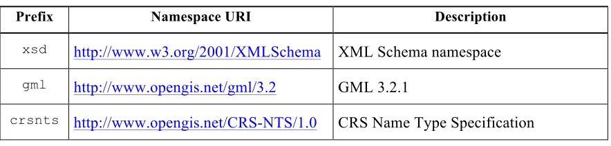
6.1 Namespace prefix conventions
The following namespaces are used in this document. The prefix abbreviations used constitute conventions used here, but are not normative. The namespaces to which the prefixes refer are normative, however.
Table 1 — Namespace mappings
Prefix Namespace URI Description
xsd http://www.w3.org/2001/XMLSchema XML Schema namespace gml http://www.opengis.net/gml/3.2 GML 3.2.1
crsnts http://www.opengis.net/CRS-NTS/1.0 CRS Name Type Specification
Note the crsnts namespace is only needed for dealing with Parameterized CRSs as described in Clause 10. It is not needed for handling CRS URIs, nor is it needed for handling GML CRS definitions.
6.2 BNF notation
OGC 11-135r2
6 Copyright © 2013 Open Geospatial Consortium.
7 CRS definition and identifier 7.1 Overview
This Clause establishes requirements class crs-nts. This is the mandatory core conformance class of this specification.
When expressing the location of some object in space and time through coordinates, these coordinates need to have an unambiguous reference which usually is given by a Coordinate Reference System (CRS). Typically, however, it is inconvenient for both producer and consumer of such information to communicate the complete definition of the CRS used; rather, a unique identifier is preferred – even more so as the vast majority of applications relies on some community accepted standard CRSs. The OWS Common standard [OGC 06-121r9] specifies that each specific OGC Web Service shall always reference a CRS by using a XML attribute or element with the type anyURI. Such an
anyURI value can be used to reference a CRS whether or not the definition of that CRS is included in the same data transfer and whether or not can be accessed electronically from some server. Subclause 10.3.2 of OWS Common [OGC 06-121r9] specifies when and how to use URLs to reference a CRS or CRS-related object; subclause D.14 summarizes many of the requirements for referencing CRSs.
This OGC® Name Type Specification for Coordinate Reference Systems specification establishes a syntax for such anyURI items. In its basic form, a URI uniquely identifies a CRS (see Clause 7). Through a parametrization mechanism, the mere identification is extended beyond single CRS
Identifiers to also express sets of CRSs, instantiations obtained from Parameterized CRSs, and ad-hoc combination of CRS components. This document does not specify where these different CRS URI mechanisms are allowed; for example, OGC specifications may allow Parameterized URIs in some places, and sometimes require Unique CRS URIs.
Example A typical situation occurs with the OGC Web Coverage Service (WCS) [OGC 09-110r4]. Its CRS Extension [OGC 11-053] allows incompletely specified CRS URIs in the Capabilities document, thereby enabling a compact presentation of the CRSs supported by a particular service. In a GetCoverage request, on the other hand, a unique CRS URI must be passed to the server to concretely specify the coordinate transformation to be applied.
7.3 Syntax
7.3.1 General CRS Identifier syntax
Requirement 1 req/query-format:
A CRS Identifier shall conform with the URL format as defined in IETF RFC 2396 [3]:
[ ”http:” hier_part [ ”?” query ] ] [ ”#” fragment ]
Requirement 2 req/reserved-chars:
7 Copyright © 2013 Open Geospatial Consortium.
Example 1 A coverage document may contain a local CRS definition referred to by the srsName attribute:
srsName=”#my_local_CRS”
Example 2 Company ACME may offer CRS definitions (i.e., employ a CRS Identifier resolver) understanding CRS URLs like http://www.acme.com/def/this-is-EPSG-4326.
Example 3 The following URL resolves to a set of CRSs, namely all EPSG CRSs, in their current version, available in the OGC CRS Name Resolver: http://www.opengis.net/def/crs/EPSG/0/.
Note Generally, not all possible parameter values will identify some existing (or meaningful) CRS. The authoritative decision about validity of OGC CRS URIs is with the OGC CRS Name Resolver with service endpoint www.opengis.net/def.
Example 1 The OGC CRS Name Resolver returns a GML CRS definition of the WGS84 reference system when provided with URL http://www.opengis.net/def/crs/EPSG/0/4326.
Example 2 The OGC CRS Name Resolver returns a 404 error code when provided with URL http://www.opengis.net/def/crs/EPSG/0/this-is-not-a-valid EPSG-identifier.
7.3.2 GET/KVP format
Requirement 3 req/query-format:
A CRS Identifier in GET/KVP format shall be constructed as an http GET query, following the common URL format as defined in IETF RFC 2396 [3]:
”http:” hier_part ”?” par1 ”=” val1 ”&” par2 ”=” val2 ”&” …
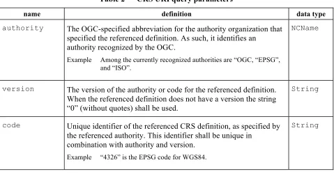
where par1, par2 etc. represent parameter names and val1, val2, etc. the value passed for the corresponding parameter as described in Table 2.
Note Like URIs in general [3], the domain part is case insensitive while the path and query part is case sensitive.
Admissible parameters for the query part (i.e., following the “?” character) in a given CRS or set of CRSs are those given by the service and by the individual CRS(s) interrogated, therefore individual. Table 2 lists CRS URI parameters reserved by OGC, together with their meanings. A particular CRS may define further parameters, as long as these do not conflict with the definitions of this standard. Every parameter value can be instantiated only once, i.e., duplicate keys are not allowed.
Requirement 4 req/no-dupes:
A CRS Identifier shall not contain duplicate keys.
Example The following does not identify a CRS, but an (infinite) CRS set because the CenterLatitude
parameter is not provided (cf. Annex A):
http://www.opengis.net/def/crs?authority=OGC&version=1.3&code=AUTO42003& UoM=m&CenterLongitude=-100
OGC 11-135r2
8 Copyright © 2013 Open Geospatial Consortium.
Table 2 — CRS URI query parameters
name definition data type
authority The OGC-specified abbreviation for the authority organization that specified the referenced definition. As such, it identifies an
authority recognized by the OGC.
Example Among the currently recognized authorities are “OGC, “EPSG”, and “ISO”.
NCName
version The version of the authority or code for the referenced definition.
When the referenced definition does not have a version the string “0” (without quotes) shall be used.
String
code Unique identifier of the referenced CRS definition, as specified by the referenced authority. This identifier shall be unique in
combination with authority and version.
Example “4326” is the EPSG code for WGS84.
String
Note The version format is sometimes of syntax “N.N.N” or “N.N”, where each “N” stands for an integer. No "v" or other version prefix is used by OGC. If no other version identification is provided by the authority, a four-digit year or other date can be used.
7.3.3 Path format
In the special case that the CRS identifier is one of Authority, but no version nor code;
authority and version, but no code; authority and version and code,
the path variant, i.e., a RESTful syntax, can be used alternatively to the query syntax.
Requirement 5 req/path-format:
A CRS Identifier in path format, that is:
”http:” hier_part ”/” AUTHORITY ”/” VERSION ”/” CODE
shall be equivalent to
”http:” hier_part ”?” “authority” ”=” AUTHORITY
”&” “version” ”=” VERSION
”&” “code” ”=” CODE
9 Copyright © 2013 Open Geospatial Consortium.
Example 1 The two URIs below are equivalent in identifying the WGS84 CRS: http://www.opengis.net/def/crs/EPSG/0/4326
http://www.opengis.net/def/crs?authority=EPSG&version=0&code=4326
Example 2 The URI for the OGC CRS with code 4326 specified in the EPSG database [2] can be expressed as ?http://www.opengis.net/def/crs/EPSG/0/4326
Example 3 The URI for all OGC / EPSG CRSs in the EPSG database [2] can be expressed as http://www.opengis.net/def/crs/EPSG
Example 4 A fictitious oarganization, ACME, might establish its own proprietary EPSG 4326 definition through http://www.acme.com/def/this-is-EPSG-4326.
Note This syntax establishes backward compatibility to pre-existing OGC CRS URIs.
7.4 Semantics
The semantics of a CRS URI is given by the response obtained from the server receiving and resolving the URI. Depending on the completeness of the CRS URI, different cases are possible:
If the CRS URI references a complete CRS definition by containing authority, version, and code parameters identifying a GML document whose root is in the substitution group of
gml:AbstractCRS) then the response is this CRS definition.
If in the CRS URI references a set of definitions by leaving out one or more of the
authority, version, and code parts then the response is an unordered sequence of CRS definitions, with one definition for each value combination available on the server.
Requirement 6 req/representation-complete-crs:
The resource pertaining to a CRS URI which identifies a CRS whose root is in the substitution group of gml:AbstractCRSshall be the definition of the CRS identified.
Requirement 7 req/representation-crs-list:
The resource pertaining to a CRS URI referring to CRS definition , but with either code or version
and code or authority, version, and code parameters missing in the URI shall be a
crnts:CRSList containing exactly those CRS definitions stored in the server which match the CRS URI and where the missing parameters act as wildcards matching any value.
CRS and CRS list responses are expressed in GML. Requirement 8 req/representation-gml-default:
By default, the representation delivered in response to a CRS Identifier shall be encoded in GML [OGC 07-036].
Note In future, further encodings beyond GML may be supported, such as WKT.
OGC 11-135r2
10 Copyright © 2013 Open Geospatial Consortium.
Example 2 The following URL does not provide a value for parameter CenterLongitude and, hence, will return the Parameterized CRS definition, which has as its document root a crsnts:ParameterizedCRS
element:
http://www.opengis.net/def/crs?authority=OGC&version=1.3&code=AUTO42003&UoM=m
8 Axis identifiers 8.1 Overview
Coordinate system axes can be spatial (example: latitude, elevation), temporal, or none of both (ex-ample: pressure). While these concepts are uniquely defined, they frequently have several synonyms, for example, elevation is synonymous to bathymetry, altitude, height, and z. Likewise, CRS Axis URIs uniquely define axes for use in CRS definitions, but allow synonyms.
8.2 Syntax
Requirement 9 req/path-format:
A CRS Axis Identifier shall be a URL which has the common URL format as defined in IETF RFC 2396 [3]:
[ ”http:” hier_part [ ”?” query ] ] [ ”#” fragment ]
Note Following URI construction rules [3], parameter keys in the query are case insensitive, while values are case sensitive.
Example 1 A coverage document may contain a local CRS definition containing a locally defined axis referred to by
#my_local_z_axis.
Example 2 Company ACME may offer CRS definitions (i.e., employ a CRS Identifier resolver) understanding CRS URLs like http://www.acme.com/def/axis/this-is-latitude.
Example 3 The OGC definition of longitude is retrieved through this URL when passed to the OGC CRS Resolver: http://www.opengis.net/def/axis-name/EPSG/0/9902.
Requirement 10req/reserved-chars:
In an Axis Identifier, characters in values which are reserved in [OGC 09-048r3] shall be encoded in the percent notation defined in IETF RFC 2396 [3].
8.3 Semantics
Requirement 11req/semantics:
The resource identified by an Axis Identifier shall be the GML representation of the coordinate axis identified, as a GML document with root element gml:CoordinateSystemAxis.
Example Axis URL http://www.opengis.net/def/axis/elevation identifies this axis:
<gml:CoordinateSystemAxis gml:id="ogrcrs4" gml:uom="urn:ogc:def:uom:EPSG::9904"> <gml:name>elevation</gml:name>
<gml:axisID>
11 Copyright © 2013 Open Geospatial Consortium. <gml:axisAbbrev>z</gml:axisAbbrev>
<gml:axisDirection>up</gml:axisDirection> </gml:CoordinateSystemAxis>
Axis definitions contain an elementgml:AxisAbbrevwhich defines a short name for an axis. When this name is unambiguous (e.g., when the CRS under consideration is specified additionally) this axis abbreviation can be used in place of the full URI axis identifier.
Requirement 12req/abbreviation:
In a context where the CRS on hand is defined unambiguously, using an identifier URI of one of the axes defined in said CRS shall be equivalent to any of the axis abbreviations defined in the CRS referenced or in some <gml:AxisAbbrev> element within the axis definition referenced by the axis URI.
Example The WGS84 CRS, and geographic CRSs in general, adopts the geodetic latitude axis, identified by http://www.opengis.net/def/axis/EPSG/0/106. This axis uses measures in degrees (e.g. referenced as
deg, as by uom attribute http://www.opengis.net/def/uom/EPSG/0/9122). It is abbreviated as Lat whose name is stated as Geodetic latitude in the axis definition (http://www.opengis.net/def/axis-name/EPSG/0/9901). Thus, the envelope of a coverage in the geographic space can be described as follows:
<gmlcov:GridCoverage … gml:id="C0001"> <gml:boundedBy>
<gml:Envelope
srsName="http://www.opengis.net/def/crs/EPSG/0/4326” axisLabels="Lat Long"
A CRS must not contain the same axis identification twice. Should a CRS need to contain two axis of the same kind – e.g., two temporal dimensions as used in climate simulation – then the axis
abbreviation must be changed for one to be different. Requirement 13req/compatibility:
In a CRS Identifier, any given axis shall not occur more than once.
Example An axis renaming can be done by way of query parameters over a Parameterized CRS definition (cf. Clause 10) which targets the reference CRS. Assuming a (hypothetical, not existing) Parameterized CRS http://www.opengis.net/def/crs/myAuth/myVersion/my-EPSG-4267 has been created, enabling axes abbreviations' customization on the target CRS http://www.opengis.net/def/crs/EPSG/0/4267 (2D NAD27 CRS) via parameters called lat-label and long-label, then the following URI renames the axis abbreviation to myPersonalLatitudeLabel and myPersonalLongitudeLabel:
http://www.opengis.net/def/crs/myAuth/myVersion/my-EPSG-4267?lat-label=myPersonalLatitudeLabel&long-label=myPersonalLongitudeLabel
OGC 11-135r2
12 Copyright © 2013 Open Geospatial Consortium.
<gmlcov:GridCoverage … gml:id="C0001"> <gml:boundedBy>
<gml:Envelope srsName="http://www.opengis.net/def/crs/ myAuth/myVersion/my-EPSG-4267? lat-label=myPersonalLatitudeLabel& long-label=myPersonalLongitudeLabel" axisLabels="myPersonalLatitudeLabel myPersonalLongitudeLabel" uomLabels="deg deg"
A Compound CRS is a CRS consisting of a non-repeating sequence of two or more single coordinate reference systems, none of which can itself be compound, as defined in OGC Abstract Topic 2 / ISO 19111-2 [OGC 08-015r2]. This way, Compound CRSs allow to establish higher-dimensional CRSs. This Clause describes a URI-based naming scheme for Compound CRSs.
9.2 Syntax
A special case of a CRS URI is when the parameter value provided itself is a URI, such as CRSs and coordinate axes.
A Compound CRS URI is a CRS Identifier with code crs-compound, together with further numbered parameters whose values are URIs themselves. A Compound CRS URI describes recombination of CRSs into a new CRS.
Requirement 14req/format:
A CRS Identifier in Compound CRS URI format shall contain a path element crs-compound. Requirement 15req/input-crs-list:
A CRS Identifier in Compound CRS URI format shall contain n>1 query parameters with keys “1” through “n” (in decimal notation) whose corresponding values are CRS Identifiers.
Requirement 16req/predefined-crs-only:
A CRS Identifier in Compound CRS URI format shall, in its query parameters, only contain CRS Identifiers for complete CRSs, i.e., CRSs whose root element is in the substitution group of gml:AbstractCRS.
Requirement 17req/no-duplicates:
13 Copyright © 2013 Open Geospatial Consortium.
Note 1 A CRS Identifier, regardless of whether expressed in query or path format, may contain additional query parameters, as long as no parameter name conflicts occur.
Note 2 There does not need to pre-exist any well-known CRS definition matching this new CRS.
Example Obtaining pressure/time slices from a 4D latitude/longitude/time/pressure atmospheric data cube requires a pressure/time CRS, for which no CRS standard exists. A Compound CRS allows to express a CRS identifier for this situation.
Requirement 18req/unique-axes:
In a Compound CRS URI, all axes in the CRSs listed shall be pairwise different.
Note Axes can be the same (e.g., Northing) while their identifiers are distinct.
Example 1 To define a 3D spatio-temporal CRS for satellite image time series, with axis order latitude-longitude-time, the WGS84 CRS may be combined with a temporal CRS, such as ansi-date2:
http://www.opengis.net/def/crs-compound?
1=http://www.opengis.net/def/crs/EPSG/0/4326 &2=http://www.opengis.net/def/crs/OGC/0/ansi-date
Example 2 The URI for combining the CRSs EPSG 4269 (NAD83) and EPSG 5713 (Canadian Geodetic Vertical Datum of 1928), adding in height, is:
http://www.opengis.net/def/crs-compound?
1=http://www.opengis.net/def/crs/EPSG/0/4269 &2=http://www.opengis.net/def/crs/EPSG/0/5713
Requirement 19req/axis-sequence:
In the CRS definition resulting from resolving a Compound CRS, axes shall appear in the order (i) of the query parameters listed in the URI and (ii) of the axis order within each CRS listed.
Example In a request like
http://www.opengis.net/def/crs-compound?1=crs1&2=crs2
where crs1 has axis order (a,b) and crs2 has axis order (c,d), the resulting CRS will have an axis order of (a,b,c,d).
10 Parameterized CRS 10.1 Overview
A Parameterized CRS is a CRS which contains variables.
10.2 Syntax
A Parameterized CRS definition consists of a reference to a CRS definition plus a list of parameter names (i.e., variables) and optional default values. A Parameterized CRS URI can contain a query part with a list of key/value pairs where values are assigned to variables defined in the Parameterized CRS.
2
OGC 11-135r2
14 Copyright © 2013 Open Geospatial Consortium.
10.3 Semantics
The semantics of a Parameterized CRS URI is given by the response obtained from the server receiving and resolving the URI. If a CRS URI references a Parameterized CRS definition (i.e., a GML document whose root is of type crsnts:ParameterizedCRS) then the resolver response is obtained from the Parameterized CRS definition by substituting all formal parameters by their values. These values can be provided either in the CRS URI or can be satisfied via default values in the Parameterized CRS definition itself.
If, after this substitution, some unsatisfied parameters remain then the response is of type
crsnts:ParameterizedCRS and contains only those reference crsnts:Parameters which remain unsatisfied.
If, after this substitution, no unsatisfied parameters remain then the response is in the substitution group of gml:AbstractCRS.
Requirement 20req/representation-parameterized-incomplete:
The resource pertaining to a CRS URI which identifies a CRS whose root is in the substitution group of crsnts:ParameterizedCRSand wherenotall formal parameters of this Parameterized CRS definition are provided (either in the CRS URI or satisfied via default values in the Parameterized CRS definition) shall be the crsnts:ParameterizedCRSwith all parameters provided are removed from the crsnts:parameters list and their values properly substituted in the
crsnts:targetReferenceSystem.
Requirement 21req/representation-parameterized-complete:
The resource pertaining to a CRS URI which identifies a CRS whose root is in the substitution group of crsnts:ParameterizedCRSand whereall formal parameters of this Parameterized CRS definition are provided (either in the CRS URI or satisfied via default values in the Parameterized CRS definition)
shall be the gml:AbstractCRS definition referenced in the crsnts:targetReferenceSys-tem of the CRS identified, with all parameters properly substituted.
Example The following is a sample Parameterized CRS definition expressed in GML:
<ParameterizedCRS
xmlns="http://www.opengis.net/crs-nts/1.0" xmlns:gml="http://www.opengis.net/gml/3.2" xmlns:xlink="http://www.w3.org/1999/xlink"
xmlns:xsi="http://www.w3.org/2001/XMLSchema-instance" gml:id="parameterized-crs-4326">
<gml:identifier codeSpace="JUB">
http://www.opengis.net/def/crs/AUTO/1.3/42001 </gml:identifier>
15 Copyright © 2013 Open Geospatial Consortium. <parameter name="central_meridian">
<value>-183.0 + ${zone} * 6.0</value> <target>//greenwichLongitude</target> </parameter>
<parameter name="false_northing">
<value>(${lat} >= 0.0) ? 0.0 : 10000000.0</value> <target>//falseNorthing</target>
</parameter> </parameters>
<targetReferenceSystem
OGC 11-135r2
16 Copyright © 2013 Open Geospatial Consortium.
Bibliography
17 Copyright © 2013 Open Geospatial Consortium. Annex A
(non-normative) OGC CRS Name Resolver
This Annex describes the OGC CRS Name Resolver for CRS URIs as defined in this specification. The OGC CRS Name Resolver delivers definitions identified by CRS and Axis URIs, provides Para-meterized CRS definitions, and builds CRS specifications through composition and concatenation.
A.1 Implementation and availability
The concepts established in this document describe the OGC CRS resolver. This CRS Name Resolver, SECORE (Semantic Cordinate Reference System Resolver),is implemented in Java using the BaseX embedded XML database system (www.basex.org). The source code of SECORE is provided and maintained by Jacobs University and rasdaman GmbH as open-source Java code published under GNU LGPL as part of the rasdaman software. In the rasdaman source tree available from www.rasdaman.org it can be found in subdirectory applications/secore/.
A.2 Service elements
The OGC CRS Name Resolver accepts Axis and CRS Identifiers as input URLs. Further, it accepts general XQuery requests on its CRS database.
A.3 Service URI
The OGC CRS Name Resolver is accessible at the following service endpoint: http://www.opengis.net/def/axis for Axis Identifier URLs
http://www.opengis.net/def/crs for CRS Identifier URLs and Parameterized CRS URLs http://www.opengis.net/def/crs-compound for Compound CRS URLs
http://www.opengis.net/def/crs-equals for semantic CRS URL comparison, see A.8 http://www.opengis.net/def/crs-query for general XQuery requests, see A.9
A.4 Service syntax
The OGC CRS Name Resolver accepts queries in the syntax defined in this Name Type Specification.
A.5 URI Resolution
OGC 11-135r2
18 Copyright © 2013 Open Geospatial Consortium.
Parameters in the URI query must all match; non-matching parameters will raise an exception.
A.6 Parameterized CRS definitions A.6.1 Overview
CRS definitions can be parameterized with one or more named parameters which are declared explicitly in the corresponding definition. As such, they describe (possibly infinite) sets of concrete CRSs.
Note This term “parameterized” should not be mixed up with the term “parametric” in OGC Abstract Topic 2 / ISO 19111-2 [10] which has a significantly different meaning.
Parameters can be resolved through values provided in the CRS URI, or through defaults defined in the CRS definition. Additionally, expressions (“formulae”) can be associated with a Parameterized CRS which evaluate to values when instantiated with parameter values. All values, whether instantiated in a URL request or coming from a default or a formula, can be substituted in one or several places in the concrete CRS definition associated with the Parameterized CRS.
Example The following URI defines the Auto Orthographic CRS 42003 specified in Subclauses 6.7.3.4 and B.9 of WMS 1.3 [4] for “meter” as unit of measure and centered at 100° West longitude and 45° North latitude: http://www.opengis.net/def/crs?authority=OGC&version=1.3&code=AUTO42003&
UoM=m&CenterLongitude=-100&CenterLatitude=45
Note Additional examples of not-completely-specified objects are specified in Subclauses B.7, B.8, B.10, and B.11 of WMS 1.3 [4], and in Subclauses 10.1 through 10.3 of [OGC 05-096r1] .
A.6.2 Structure
Formally, a Parameterized CRS is a GML document with root crsnts:ParameterizedCRS. It contains an element crsnts: targetReferenceSystem referring to some instantiatable subtype of gml:AbstractCRS, together with a list of formal parameters.
Parameters are crsnts:Parameter elements listed in the crsnts:Parameters section. A formal parameter consists of
a name which is locally unique within the Parameters element,
an optional crsnts:value element holding a default value consisting of either a constant or a formula (see below for its syntax), and
an optional crsnts:target containing an XPath expression indicating one or more substitution points relative to the targetReferenceSystem subnode.
19 Copyright © 2013 Open Geospatial Consortium.
Note In particular, a formula cannot have its own parameter name as a free parameter.
The target expression in crsnts:target indicates the places where, during request evaluation, the resulting parameter (obtained from URL input, or formula evaluation, or by using the default) gets applied to the CRS definition, assuming crsnts:targetReferenceSystem as the relative document root for XPath evaluation. The XPath item indicates one or a set of substitution points relative to the CRS subnode.
Example The following XML snippet defines a geodetic Parameterized CRS with formal parameter x substitut-ing parameter values in all (fictitious) axisName elements appearing the gml:GeodeticCRS
root of the CRS definition:
<crsnts:ParameterizedCRS> <gml:identifier>
</gml:identifier>
<gml:scope>…</gml:scope> <crsnts:parameters>
<crsnts:parameter name=”lon”>
<crsnts:value>90</crsnts:value>
<crsnts:target>//longitude | //Longitude</crsnts:target> </crsnts:parameter>
<crsnts:parameter name="zone">
<crsnts:target>//greenwichLongitude</crsnts:target> <crsnts:value>
min(floor((${lon} + 180.0) / 6.0) + 1,60) </crsnts:value>
</crsnts:parameter> </crsnts:parameters>
<crsnts:targetReferenceSystem
xlink:href="http://www.opengis.net/def/crs/EPSG/0/4326"/> </crsnts:ParameterizedCRS>
A.6.3 Resolution
The result of a URI request against a Parameterized CRS depends on the degree of parameter matching, it is a GML document with its root being an instantiatable subtype of either
gml:AbstractCRS or crsnts:ParameterizedCRS. The response is:
In case all formal parameters in the Parameterized CRS addressed are resolved the result is a
gml:AbstractCRS.
Example Assuming that the name of the above Parameterized CRS example is my-own-crs, a possible instantiation of this Parameterized CRS to a concrete CRS Identifier is
http://www.opengis.net/def/crs/my-own-crs?lon=47.6
The response to this instantiation is
<gml:GeodeticCRS> …
<gml:GeodeticCRS>
OGC 11-135r2
20 Copyright © 2013 Open Geospatial Consortium.
Example Assuming the same example as above, the Parameterized CRS itself can be obtained through
http://www.opengis.net/def/crs/my-own-crs
The response to this request is
<crsnts:ParameterizedCRS>
The corresponding XML Schema is available from http://schemas.opengis.net/crs-nts.
A.7 Flattening of CRS definitions
As opposed to classic CRSs, the concepts introduced here allow nested and parameterized definitions of CRSs. When resolving a CRS URI, tools and human users sometimes may want to obtain the high-level definition indicating how a CRS is composed form other CRSs, and sometimes may want to get an expanded view with all references to other CRSs resolved. An optional parameter in URIs allows obtaining CRS definitions at selectable degrees of resolution.
A CRS URI can be appended with an optional query parameter, expand, which allows to control how far xlinks in the document returned are resolved. This parameter can have the following values:
none: do not follow and resolve any xlink element in the CRS definition addressed. all: resolve all xlink elements in the CRS definition addressed. This is the default. n where n is an integer number greater than zero: resolve xlinks up to n nesting levels.
Example 1 ...&expand=none – during resolution, do not resolve any xlinks.
Example 2 ...&expand=all – during resolution, resolve all xlinks.
Example 3 ...&expand=2 – during resolution, follow up to two xlinks in sequence.
A.8 CRS equality
21 Copyright © 2013 Open Geospatial Consortium.
Example Comparing EPSG codes 4327 and 4326 can be done with this URL:
http://www.opengis.net/def/crs-equals?
1=http://www.opengis.net/def/crs/EPSG/0/4327 &2=http://www.opengis.net/def/crs/EPSG/0/4326
The response will look like this:
<crsnts:comparisonResult
Note that the text provided in crsnts:reason is not standardized, but implementation dependent.
A.9 XQuery
An XQuery GET or POST request sent to URL http://www.opengis.net/def/crs-query will result in a document obtained from evaluating the XQuery request according to the XQuery standard [6].
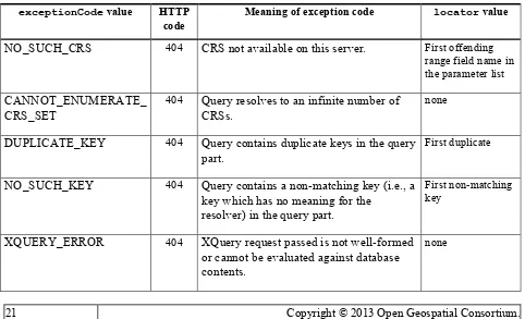
A.10 Exceptions
Exceptions shall be thrown in the situations described in Table 3, with the http code and values indicated there.
Table 3 — CRS resolver exception codes
exceptionCode value HTTP code
Meaning of exception code locator value
NO_SUCH_CRS 404 CRS not available on this server. First offending range field name in the parameter list
CANNOT_ENUMERATE_ CRS_SET
404 Query resolves to an infinite number of CRSs.
none
DUPLICATE_KEY 404 Query contains duplicate keys in the query part.
First duplicate
NO_SUCH_KEY 404 Query contains a non-matching key (i.e., a key which has no meaning for the
resolver) in the query part.
First non-matching key
XQUERY_ERROR 404 XQuery request passed is not well-formed or cannot be evaluated against database contents.
OGC 11-135r2
22 Copyright © 2013 Open Geospatial Consortium.
NO_SUCH_EXPAND_ VALUE
404 An expand query parameter has been provided with an illegal value.