HIGH-PRECISION POSITIONING AND REAL-TIME DATA PROCESSING OF
UAV-SYSTEMS
M. Rieke a, *, T. Foerster a, J. Geipel a, T. Prinz a
a Institute for Geoinformatics - University of Muenster, Weseler Str. 253, 48151 Muenster, Germany -
(m.rieke, theodor.foerster, jakob.geipel, prinz)@uni-muenster.de
Commission I, WG I/V
KEY WORDS: UAVs, Sensor Integration, Real Time Kinematics, Real-time Processing, Software Framework
ABSTRACT:
Available micro-sized Unmanned Aerial Vehicles (UAVs) in the civilian domain currently make use of common GPS receivers and do not address scenarios where high-precision positioning of the UAV is an inevitable requirement. However, for use cases such as creating orthophotos using direct georeferencing, an improved positioning needs to be developed. This article analyses the requirements for integrating Real Time Kinematic positioning into micro-sized UAVs. Additionally, it describes the data processing and synchronisation of the high-precision position data for a workflow of orthorectification of aerial imagery. Preliminary results are described for the use case of precision farming. The described approach for positioning has the potential to achieve a positional accuracy of 1-3 cm, which can be considered as adequate for direct georeferencing of aerial imagery.
*
Corresponding author.
1. INTRODUCTION
Micro-sized Unmanned Aerial Vehicles (UAVs) can be considered to improve ad-hoc data collection in 3-D space significantly, using in-situ sensors (e.g., temperature) and remote sensors (e.g., aerial imagery). High-precision positioning of such UAVs is crucial for a lot of applications such as automatic waypoint navigation and remote sensing. It enables especially direct georeferencing of aerial imagery and is thereby important to create orthophotos on-the-fly. High-precision positioning for instance has already been achieved for large-sized UAVs (Nagai et al., 2009; Xiang & Tian, 2011), requiring special operating permits which are in general regulated by national authorities (e.g. “Luftverkehrs-Zulassungs-Ordnung” for Germany; BMJ, 2011). However, high-precision positioning of mirco-sized UAVs has not been presented yet. In particular, integrating Real Time Kinematic (RTK) technology into micro-sized UAVs is a challenging task regarding several limitations of such systems such as the limited amount of payload and the limited capability of raw data processing. In this article, we describe the realization of such an integration based on the Microdrones md4-200 UAV (www.microdrones.com). The presented approach makes use of national Ground Based Augmentation Systems (GBAS) (e.g. SAPOS for Germany). In particular, an additional microcontroller forwards the current GNSS (Global Navigiation Satellite System) position to the correction service using a GPRS modem and receives correction data for the current location of the UAV. The correction data can then be used by the GNSS device of the UAV to create a more accurate position (up to 1 cm accuracy).
The developed approach is applied to the real-world use case of precision farming. The use case of weed patch detection and crop nutrition assessment in precision farming to enable sustainable strategies for increasing crop yield is selected, which is interesting for near real-time aerial imaging and high-precision positioning. Several parameters determine the yield of
a production field, which include nutrition status of the crops as well as pest infestations such as weeds, animal pest or pathogens. These parameters are likely to be spatially heterogeneous for a single site (Oerke et al., 2010), thus individual controlling options (e.g. application of pesticides) for site-specific management are required. UAV systems support near real-time provision of gathered remote sensing data which is crucial in precision farming (Backes & Jacobi, 2006) to apply adequate and precise controlling options (e.g. fertilizer or pesticide application based on GPS guidance).
In this article, we describe the related work, which is applied in the presented approach, (Section 2) and the system design (Section 3) for RTK-enabled positioning as a prerequisite for direct georeferencing of aerial imagery taken by a UAV. Section 4 outlines the implementation. Finally we discuss the preliminary results and give a conclusion on the described approach (Section 5).
2. RELATED WORK
This section describes related work in the relevant topics of orthrectification, RTK and data processing.
Eisenbeiß (2009) proposed a categorization of UAVs regarding size/payload and purchase price. He characterized micro & mini-sized UAVs (M-class) to have a payload less than 5 kg and large UAVs (L-class) with more than 5 kg of payload. Table 1 lists a selection of current civilian micro-sized UAVs.
UAV Payload Positioning Mikrokopter
Quadro/Okto
0.3 – 0.8 kg common GPS Microdrones
md4-200/1000
0.3 – 1.2 kg common DGPS (using
Satellite Based
Augmentation System) International Archives of the Photogrammetry, Remote Sensing and Spatial Information Sciences, Volume XXXVIII-1/C22, 2011
UAV Payload Positioning AscTec Falcon 8 0.5 kg common GPS
Table 1: Overview of micro-sized UAVs.
In this work, we will describe the prototypical implementation of RTK integration for a micro-sized UAV – the Microdrones md4-200.
2.1 Orthorectification of UAV-acquired Imagery
Orthorectification describes the process of calculating georeferenced images using exterior and interior orientation of the remote sensing device. In principle, two different approaches are identified - indirect georeferencing and direct georeferencing. If parameters for the exterior orientation of the sensor are missing, indirect georeferencing is applied by incorporating Ground Control Points (Cramer et al., 2000). automatically georeferenced, no manual interaction is required. Grenzdörffer et al. (2008) investigated the potential of low-cost UAVs regarding applications for aerial imagery in forestry and agriculture. They discussed most influences for direct georeferencing including GPS accuracy, synchronisation of GPS and time of image acquisition and IMU attitude errors (all regarding exterior orientation) as well as interior orientation such as focal length or centre point of a digital camera. Antic et al. (2009) focus on spectral analysis (e.g. Normalized Difference Vegetation Index) of imagery acquired with a flexible-wing UAV and a valuable multispectral camera capable of sensing in the near infrared ranges (NIR). Though, they do not address georeferencing of the gathered imagery. This is briefly done by Link-Dolezal et al. (2010) by applying a fixed-wing UAV for surveying a winter wheat field regarding its multispectral reflection. They conclude that incorporating the attitude of the UAV is inevitable for georeferencing. Eisenbeiß (2009) evaluated a UAV architecture (Surveycopter UAV combined with wePilot navigation system) with respect to the accuracy of direct georeferenced aerial imagery. He underlined the need for improved data processing capabilities as well as sensors due to high impact of measurement errors of IMU and GPS devices.
For remote sensing purposes we deployed a compact digital camera which has been modified for taking images in the visible (VIS) and the near infrared (NIR) wavelength range from about 330nm to 1100nm to quadrocopter UAV (Mikrokopter) in an earlier study (Knoth et al., 2011).. Nevertheless, this approach showed limitations concerning automatic orthorectification and positional accuracy. Thus, we have investigated first assumptions on improving positioning of UAV systems by aligning DGPS and IMU measurements (Geipel et al., 2011). 2.2 Real Time Kinematics
Real Time Kinematics is a specialized form of Differential GNSS but in contrast it also takes phase observation into consideration for estimating the measurement error of the GNSS receiver (Gopi, 2005). It receives correctional signals of regional (e.g. nation-wide) services (GBAS) using a common GPRS/UMTS modem. Sugiura et al. (2005) used RTK to
improve positioning of a large-sized helicopter system. The evaluation of georeferenced aerial imagery showed positioning errors of approximately 30cm. Recently, Xiang & Tian (2011) deployed RTK components on a large-sized helicopter UAV for surveying. GPS measurements have been combined with IMU data using an Extended Kalman Filter (e.g. Brown & Hwang, 1996). The calculated area was compared to ground-based GPS surveying and showed a variance of approximately up to 1.5 %. Nagai et al. (2009) used RTK-GPS on a large-sized helicopter UAV combined with image-based bundle-block adjustments to improve accuracy of direct georeferencing. The UAV was applied to create a 3D surface model calculated from data of a laser scanning device textured with the gathered aerial imagery. 2.3 Data Processing
Data Processing is always performed on the ground station, where the gathered data of the UAV is combined and synchronized for further analysis. Several approaches for combining sensor data of heterogeneous sources have been investigated (e.g. Aberer et al., 2006; Moodley & Simonis, 2006). Nevertheless, none of the existing approaches address the reliable synchronisation with respect to required accuracy of specific properties which is a fundamental requirement for data processing of UAVs.
In an earlier study we developed a generic approach for fusion of sensor data with the UAVs GPS measurements which have been provided as uncoupled data streams. We used a Mikrokopter UAV as a multi-sensor platform for in-situ measurements of the surface-near atmosphere to determine meteorological inversions and introduced a software framework to synchronize the uncoupled data streams gathered by the UAV (Rieke et al., 2011).
3. DESIGN
We aim at an approach to enable micro-sized UAVs as multi sensor platforms for generating high precision geodata such as orthophotos. We use a Microdrones md4-200 as the basic sensor platform to enhance it with additional hardware to gather position and attitude information as well as aerial images. On the software side, the gathered data is combined, synchronized and generated according to specific output formats. Therefore, this processed data can be used as input for automatically creating orthophotos. Although, our approach addresses the integration of GNSS hardware into the md4-200 and applying corresponding communication patterns, it will yield some general insights for integrating such components into existing micro-sized UAVs.
3.1 Orthorectification of Aerial Imagery
Orthorectification of images in remote sensing is achieved by determining the parameters of interior orientation of the focal camera system and by determining of the exterior orientation which describes the position of the camera’s viewpoint and the camera’s orientation in an earth-centered, earth-fixed coordinate reference system (Kraus, 2007). While the parameters of the interior orientation of the camera are defined by calibration regarding the focal distortion, the parameters of exterior orientation can be determined by applying two different approaches, the direct and the indirect georeferencing method (Figure 1).
We will use direct georeferencing to reduce the fieldwork to a minimum. In this approach, we will exploit the UAV’s sensor information of position (GNSS) and attitude (IMU) in combination with an additional Terrain Model to calculate the exterior orientation of the images without the need of ground control points (Kraus, 2007).
Figure 1: Orthorectification workflow.
3.2 Integration of RTK Mechanism
The majority of available UAVs is equipped with standard low-cost GPS receivers which provide an absolute position accuracy of about 2m to 15m. As these measurements are too inaccurate for the purposes of determining the precise focal 3D position of the mounted camera, the GPS information needs to be improved by upgrading the md4-200 with a differential GNSS receiver using satellite signals from NAVSTAR GPS (USA) and GLONASS (Russia). Moreover, the GNSS receiver has to be coupled to an advanced active dual-frequency GNSS antenna to make use of all available navigation systems and their different signals.
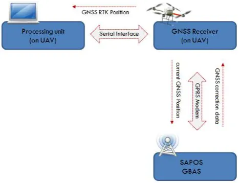
Figure 2: RTK high-level architecture.
We focus on integrating RTK measurements into the md4-200’s navigation system to retrieve position accuracy of about 1 cm to 3 cm (Bauer, 2002). The advanced GNSS system makes use of GBAS services (e.g. SAPOS for Germany). In particular, an
additional microcontroller forwards the current GNSS position to the SAPOS correction service using a GPRS modem and in response gets correction data for location of the UAV (Figure 2). The correction data can then be used by the GNSS device of the UAV to create a more accurate position using Global Navigation Systems like NAVSTAR GPS, GLONASS and prospective Galileo.
3.3 Data Processing
As emphasized by Grenzdörffer et al. (2008) and Eisenbeiß (2009) the time of image acquisition has to be aligned with the data stream of the exterior orientation. To use position data of a UAV in general within different use cases we have developed a software framework that overcomes several issues regarding the synchronization of different sensor data (Rieke et al., 2011). It can be applied in different situations, especially for providing the trajectory of a UAV as a continuous time series. This mechanism is applicable and sufficient for scenarios where a high accurate position of the UAV is an inevitable necessity. This includes but is not limited to direct georeferencing. For instances a UAV deployed with in-situ sensors needs to take its position into account when enriching sensor measurements with location information. Regarding direct georeferencing the mechanism must be capable of processing the following properties:
RTK-improved GNSS position
IMU measurements
Time of image acquisition.
Most available UAVs comprise an integrated strapdown algorithm which takes the GPS position and IMU as inputs integrated in the navigational unit. The strapdown algorithm is realized with Kalman Filtering and has been the topic of several research studies (e.g. Dorobantu & Zebhauser, 1999; Kumar, 2004; Mao et al., 2007). It is used for stabilizing the UAVs attitude. In most cases it is computed in the navigational unit of the UAV in a proprietary manner. Hence it is not possible to extract this trajectory data for enriching sensor measurements with accurate position data. Thus we designed a similar functionality which can be applied externally to compute a continuous trajectory time series.
Figure 3: Stream synchronization.
The processing software must be designed in a generic configurable way addressing the different needs for synchronization of properties. Figure 3 illustrates the intended behaviour. Besides the synchronization mechanism the software need to be capable of providing the coupled data in a flexible manner regarding output formats as the data needs to be International Archives of the Photogrammetry, Remote Sensing and Spatial Information Sciences, Volume XXXVIII-1/C22, 2011
integrated into existing software solutions for orthorectification such as Erdas Imagine LPS.
In the case all required data is available (as illustrated in Figure 3) the synchronization mechanism takes the timestamp of the pre-configured property (e.g. timestamp of image acquisition) as an input for computing the high-precise position (trajectory based on RTK-GNSS and IMU) and the attitude (IMU and magnetic compass) providing the required parameters for direct georeferencing.
4. IMPLEMENTATION
In this section we describe the realization and implementation of the onboard sensor system as well as the software components.
4.1 Onboard Sensor System
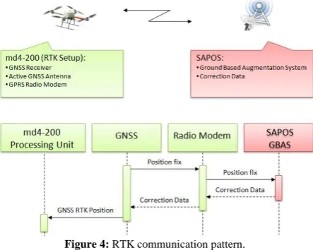
The standard onboard sensor system of the md4-200 consists of a common GPS receiver, a magnetic sensor, a barometric sensor and an Inertial Measurement Unit (IMU) based on three gyroscopes and three accelerometers. As previously described, we will prototypically improve the system by replacing the GPS unit with an RTK-capable GNSS device. Currently we are using a GBAS DGPS receiver which will be replaced with the RTK-capable GNSS device in the near future. Additionally we added an active GNSS antenna, a GPRS radio Modem and a compact digital camera (Figure 4).
Figure 4: RTK communication pattern.
This compact digital camera has been customized and attached to the UAV’s processing unit. Thus, we are able to capture images remotely triggered by the controls of the RC. To synchronize the captured images with the UAV’s position and attitude, it is essential to generate an additional, accurate timestamp for each taken image. We decided to use GNSS time as time measurement standard and to generate timestamps using a GNSS enabled digital camera that automatically creates a GNSS timestamp for each taken image. For the case of using a camera system which is not GNSS enabled we are currently developing an alternative method by detecting the moment of triggering an image through connecting the camera’s hotshoe to the UAV’s processing unit that hereupon generates a timestamp by using time information of the RTK-system.
4.2 Communication Mechanisms
The Microdrones md4-200 comprises of a wireless communication link using a 2.4 GHz quad-diversity connection to transmit flight data such as attitude and position of the UAV. As the RTK components will be integrated in the overall architecture of the UAV (Section 4.1) the transmitted position will be already RTK-improved. We are currently working on the communication patterns for the transmission of the image and its corresponding timestamp. This can be included in the md4-200s communication messages but can also be transmitted through a standalone wireless link (Figure 5). The latter approach has benefits over the first regarding the portability of the architecture onto other UAVs as it does not be depend on the proprietary message format.
Figure 5: High-level communication pattern.
4.3 Data Processing
We developed a framework consisting of a swappable component mechanism for interpolating a time series for an individual timestamp. Thus, we are able to fulfill the requirements of varying scenarios where different interpolation mechanisms (e.g. linear, spline) are reasonable by adjusting the internal algorithm in a flexible way. The developed framework is configurable regarding the synchronization of properties. Thus it can derive all other needed properties (i.e., trajectory and attitude) for the timestamp of image acquisition through calculation. Following the described requirements in Section 3.3, the framework is capable of plugging in several Output-Plugins. These Output-Plugins can be used to transform the raw data to higher level information for integrating the gathered data into Web services of for instance the Sensor Web (Botts et al., 2006; Bröring et al., 2011). The processed information can also be integrated into software packages such as Erdas Imagine LPS using appropriate formats.
5. CONCLUSION AND FUTURE WORK
High precision positioning of micro-sized UAVs is an important but unsolved task. In particular, high-precision positioning in 3D space is important for remote sensing and automatic waypoint navigation of UAVs. We present an approach based on RTK and national correction service (SAPOS) for high-precision positioning. Next steps will cover the integration of valuable GNSS hardware to achieve positional accuracy in the sub-decimeter range as shown by Bauer (2002). The presented approach is applied to direct georeferencing for creating ad-hoc International Archives of the Photogrammetry, Remote Sensing and Spatial Information Sciences, Volume XXXVIII-1/C22, 2011
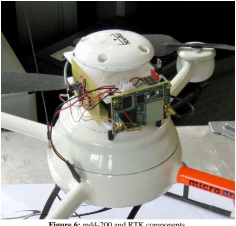
orthophotos. Such automatically created orthophotos can be used for precision farming. The approach consists of three steps (Section 4), on-board data collection, real-time communication with the ground station and data processing on the ground station. Regarding the position parameters, we have addressed two aspects of exterior orientation which limit the accuracy of direct georefencing as listed by Grenzdörffer et al. (2008). The RTK-enabled GNSS positioning and the coupling of image acquisition timestamp with position and attitude data improve not only direct georeferencing but various use cases in which high-precise positioning is required. The presented approach is implemented on a Microdrones md4-200 UAV (Figure 6).
Figure 6: md4-200 and RTK components.
Several tests of the proposed approach have already been performed regarding the data flow and the communication. The hardware composition showed several drawbacks for flying purposes regarding overall UAVs weight and shift of the centroid. Thus, we evaluated the positioning in non-flying mode. We determined a position error of approximately 90cm measured at a fixed control point. This rather high error is related to the GNSS receiver (GBAS DGPS only) as we did not deploy the most valuable RTK-enabled device available, yet. This will be the next step and will increase the position accuracy to a sub-decimeter level (1 - 3 cm; Bauer, 2002). The software synchronization approach showed good performance at the given frequency of measurements.
The next steps will include improving hardware composition to be able to evaluate the architecture during flight conditions. This evaluation will be achieved by capturing the trajectory of the UAV using a total station capable of tracking moveable objects and compare it with the trajectory measured by the UAV using statistical methods standard deviation, ranges and mean difference. The limited accuracy of low-cost IMU gyroscopes and accelerometers (Eisenbeiß, 2009) as well as magnetic compass are issues which need to be addressed.
In the future, we will also investigate how to design a scalable web service architecture to deliver the gathered data in real-time to the user (Figure 7). In this context, Complex Event Processing (Luckham, 2001) is promising to limit the communication overhead and to optimize information flow. In such scenarios, users will only be notified by specific events,
which are interesting to the user regarding location, phenomenon and time. First experiments on such event-based architectures and a mechanism to formalize such events are documented by Everding & Foerster (2011) for the use case of water quality assessment. The outcomes of these experiments will be taken as a starting point to design an event-based architecture to support decision making in precision farming.
Figure 7: Event-driven architecture for monitoring workflows.
The presented work has been carried out within the ifgicopter group (http://purl.net/ifgi/copter). We acknowledge Prof. Edzer Pebesma for supporting the ifgicopter group.
6. REFERENCES
Aberer, K., Hauswirth, M. & Salehi, A. (2006): „A Middleware for Fast and Flexible Sensor Network Deployment“. In: Proceedings of the 32nd VLDB Conference (Demo Session), p. 1199--1202.
Antic, B., Culibrk, D., Crnojevic, V. & Minic, V. (2009): „An Efficient UAV Based Remote Sensing Solution for Precision Farming“. In: BioSense - The First International Workshop on ICT and Sensing Technologies in Agriculture, Forestry and Environment, Novi Sad, Serbia.
Backes, M. & Jacobi, J. (2006): „Classification of weed patches in QuickBird images: Verification by ground truth data.“. In: EARSeL eProceedings, 5 (2).
Bauer, M. (2002): Vermessung und Ortung mit Satelliten: GPS und andere satellitengestützte Navigationssysteme. 5. ed. Wichmann, Berlin. — ISBN: 3879073600
BMJ (2011): Bundesministerium für Justiz - Luftverkehrs-Zulassungs-Ordnung. http://www.gesetze-im-internet.de/ bundesrecht/luftvzo/gesamt.pdf.
Botts, M., Percivall, G., Reed, C. & Davidson, J. (2006): „OGC® Sensor Web Enablement: Overview And High Level Architecture“.
Bröring, A. et al. (2011): „New Generation Sensor Web Enablement“. In: Sensors, 11 (3), pp. 2652-2699, doi: 10.3390/s110302652.
Brown, R.G. & Hwang, P.Y.C. (1996): Introduction to Random Signals and Applied Kalman Filtering. 3. ed. Wiley, New York, USA. — ISBN: 0471128392
Cramer, M., Stallmann, D. & Haala, N. (2000): „Direct Georeferencing Using GPS/Inertial Exterior Orientations for Photogrammetric Applications“. In: International Archives of Photogrammetry and Remote Sensing (IAPRS), Volume 33. International Archives of the Photogrammetry, Remote Sensing and Spatial Information Sciences, Volume XXXVIII-1/C22, 2011
Dorobantu, R. & Zebhauser, B. (1999): „Field Evaluation of a Low-Cost Strapdown IMU by means GPS“. In: Ortung und Navigation, 1.
Eisenbeiß, H. (2009): „UAV Photogrammetry“. (Dissertation) ETH Zurich.
Everding, T. & Foerster, T. (2011): „An Event Driven Architecture for Decision Support“. In: Proceedings of the Geoinformatik 2011 – Geochange Conference. 15-17 June 2011, Münster, Germany.
Geipel, J., Knoth, C., Elsässer, O. & Prinz, T. (2011): „DGPS- and INS-Based Orthophotogrammetry on Micro UAV Platforms for Precision Farming Services“. In: Proceedings of the Geoinformatik 2011 – Geochange Conference. 15-17 June 2011, Münster, Germany.
Gopi, S. (2005): Global Positioning System: Principles and Applications. Tata McGraw-Hill Company Ltd. Tata McGraw Hill, New Delhi, India.
Grenzdörffer, G., Engel, A. & Teichert, B. (2008): „The Photogrammetric Potential of Low-cost UAVs In Forestry and Agriculture“. In: The International Archives of the Photogrammetry Remote Sensing and Spatial Information Sciences, Beijing, China XXXVII, Part B1.
Knoth, C., Prinz, T. & Loef, P. (2011): „Microcopter-Based Color Infrared (CIR) Close Range Remote Sensing as a Subsidiary Tool for Precision Farming“. In: Proceedings of the ISPRS Workshop on Methods for Change Detection and Process Modelling, Univ. Press Cologne, Cologne, Germany.
Kraus, K. (2007): Photogrammetry: Geometry from Images and Laser Scans. 2. ed. Walter de Gruyter, Berlin, Germany. — ISBN: 3110190079
Kumar, V. (2004): „Integration of Inertial Navigation System and Global Positioning System Using Kalman Filtering“. Indian Institute of Technology Bombay, Mumbai, India.
Link-Dolezal, J., Reidelstürz, P., Graeff, S. & Claupein, W. (2010): „Einsatz eines UAV zur Erfassung von multispektralen Reflexionseigenschaften in Winterweizen“. In: Tagungsband
“Precision Agriculture Reloaded – Informationsgestützte
Landwirtschaft” Referate der 30. GIL Jahrestagung,.
Luckham, D.C. (2001): The Power of Events: An Introduction to Complex Event Processing in Distributed Enterprise Systems. Addison-Wesley Longman Publishing Co., Inc., Boston, MA, USA. — ISBN: 0201727897
Mao, G., Drake, S. & Anderson, B.D.O. (2007): „Design of an Extended Kalman Filter for UAV Localization“. In:
Information, Decision and Control, 2007. IDC ’07, IEEE pp. 224-229, doi: 10.1109/IDC.2007.374554. — ISBN: 1-4244-0902-0
Moodley, D. & Simonis, I. (2006): „A new architecture for the sensor web: The swap framework“. In: 5th International Semantic Web Conference ISWC.
Nagai, M., Tianen Chen, Shibasaki, R., Kumagai, H. & Ahmed, A. (2009): „UAV-Borne 3-D Mapping System by Multisensor Integration“. In: IEEE Transactions on Geoscience and Remote
Sensing, 47 (3), pp. 701-708, doi:
10.1109/TGRS.2008.2010314.
Oerke, E.-C., Gerhards, R., Menz, G. & Sikora, R.A. (2010): Precision Crop Protection - the Challenge and Use of Heterogeneity. Springer Science+Business Media, Dordrecht, Heidelberg, London, New York.
Rieke, M., Foerster, T. & Bröring, A. (2011): „Unmanned Aerial Vehicles as Mobile Multi-sensor Platforms“. In: Proceedings of the 14th AGILE International Conference on Geographic Information Science, Utrecht, The Netherlands.
Sugiura, R., Noguchi, N. & Ishii, K. (2005): „Remote-sensing Technology for Vegetation Monitoring using an Unmanned Helicopter“. In: Biosystems Engineering, 90 (4), pp. 369-379, doi: 10.1016/j.biosystemseng.2004.12.011.
Xiang, H. & Tian, L. (2011): „Development of a low-cost agricultural remote sensing system based on an autonomous unmanned aerial vehicle (UAV)“. In: Biosystems Engineering, 108 (2), pp. 174-190, doi: 16/j.biosystemseng.2010.11.010. International Archives of the Photogrammetry, Remote Sensing and Spatial Information Sciences, Volume XXXVIII-1/C22, 2011