HYDROLOGIC MODELLING OF KATSINA-ALA RIVER BASIN: AN EMERGING
SCENARIO FROM LAKE NYOS THREAT
J. O. Akinyede (Executive Director *); R. Babamaaji (Scientific Officer **); M. Vaatough (Scientific Officer **); K. A. Adepoju (Scientific Officer *)
* African Regional Centre for Space Science and Technology Education in English (ARCSSTE-E), Obafemi Awolowo University (OAU) Campus, Ile-Ife, Nigeria
** National Space Research and Development Agency (NASRDA, Abuja, Nigeria
Commission VIII/1
KEYWORDS: Crater, Hydrologic, vulnerability, simulations, mitigation
ABSTRACT:
Understanding the hydrologic system surrounding crater lakes is of great importance for prevention of flooding damages, conservation of ecological environment, and assessment of socio-economic impact of dam failure on the civilians in the downstream regions. Lake Nyos is a crater lake formed by volcanic activities at the Oku volcanic field on the Cameroon Volcanic Line. It is a freshwater lake with a maximum depth of 200 meter. In 1986, a limnic eruption at the lake emitted 1.6 million tonnes of carbon dioxide from the bottom of saturated water into the air and suffocated up to 1,800 people and 3,500 livestock at nearby villages. The lake waters are held in place by a natural dam composed of loosely consolidated volcanic rock, which is now at the verge of collapse due to accelerated erosion. This study was carried out to determine the flood risks and vulnerability of population and infrastructure along Katsina-Ala drainage basins. The project integrated both satellite images and field datasets into a hydrologic model for Katsina-Ala River Basin and its vicinity including the Lake Nyos. ArcHydro was used to construct a hydrologic database as ‘data models’ and MIKE SHE was employed to conduct hydrologic simulations. Vulnerable infrastructures, population and socio-economic activities were identified to assist the Federal and State governments in disaster mitigation and management plans. The result of the project provides comprehensive knowledge of hydrologic system of Katsina-Ala drainage basin to mitigate potential future disasters from a potential dam failure and manage water resources against such di sasters.
1.0 INTRODUCTION
Dam collapse is one of the most common disaster phenomena, causing considerable personal injury and property damage. Problems related to dam failures, flooding and vulnerability of populations have greatly increased in recent decades due to several factors including changes in land-use in the hinterlands, urbanization of flood-prone sites, squatter settlements and sub-standard constructions, and increased household density (Kling et al, 1987, Smith, 2001). Lake Nyos is one of the three lakes in the world that have carbon dioxide dissolved in their waters and are condensed in the lower chambers of the lakes. The lake water is held in place by a natural dam composing of loosely consolidated volcanic rock. The waters of Lake Nyos were up turned in 1986 expelling the gases into the air killing over 1700 and 3000 people and livestock respectively (Freeth and Kay, 1987). According to a recent study, the dam is at the verge of collapse due to accelerated erosion. This may lead to the release of about 50 million cubic meters of water with a consequence of severe flooding and flood disaster along the populated plains of Katsina-Ala River in Nigeria.
This paper provides background information on the hazards and potential danger posed by the lake and the collapse of its dam on the population, infrastructures, agricultural/cultural resources, socio-economic activities and other environmental consequences in the area. Reports and observations during the field work were presented. Recommendations were made on how authorities in both Nigeria and Cameroun Republics can jointly handle the looming catastrophes with the lake and other trans-boundary resources in the area using GIS based hydrological models.
2.0 DISASTERS ASSOCIATED WITH THE PREVIOUS ERUPTION
Over the years, there have been a number of recorded cases of landslides and flood disasters in the Lake Nyos region with the worst disaster occuring on 12th August, 1986. The waters of the Lake Nyos were up turned expelling a large volume of toxic gas carbon dioxide (CO2) gas into the air. About 1700 people within 25km radius of the lake mostly rural villagers as well as 3500 livestocks were affected. About 845 people were hospitalised; about 4000 inhabitants fled the area, many of these developed respiratory problems, lesions and paralysis as a result of the gases. The bodies of the people that died were generally devoid of trauma. Most victims appeared to have fallen asleep and died from asphyxiation. Properties and social amenities such as roads, buildings were also destroyed. (Freeth and Kay, 1987; Tazieff 1989; Shanklin 1988; Kusakabe et al., 1989). About 10.000-20.000 people were affected over an area of 300 km2 (Baxter and Kapila, 1989). The affected area was declared a disaster zone and more than 4,430 displaced survivors were later resettled in This deadly cloud was 50m thick and advanced down slope at a speed of 20-50km per hour. This deadly mist persisted in a concentrated form over a distance of 25km, bringing death to the villages of Nyos, Kam, Cha, and Subum.
considered free from impact caused by floods or landslides, other threats from Mount Cameroon eruption, particularly lava flows, threaten the population. (Krimsky, 1992). The need for effective decision making towards risk reduction in this region has necessitated this study, to investigate the environmental and socio-economic impact and possibilities of the emplacement of effective monitoring/early warning systems in the event of the collapse of the dam. This will enable decision makers and planners to understand areas to concentrate their concerted efforts with a view to developing mitigation measures to reduce the level of risk and to guarantee the lives of the population in this region.
2.1 Brief Description of Lake Nyos
Lake Nyos occupies a major crater formed through a hydro-volcanic eruption about 400 years ago. The lake is located on the Oku volcanic line in Northwestern region of Cameroun. It has an estimated length of 1.8 to 2.0 km and width of 1.2 km with a depth of about 208 meters. At the lowest point, the walls measures 40 meters high and 45 meters wide. According to Freeth and Kay (1987), there is a magma chamber beneath the region of the lake. This chamber holds a large volume of carbon dioxide which seeps through the charging waters of Lake Nyos with an estimated 90 million kilograms of carbon dioxide annually. The lake contains about 55 million cubic litres of oxidized waters. Overtime, the waters have become super saturated, and in an event such as earthquake or volcanic eruption, large amounts of CO2 may suddenly erupt. Most of the times, however, the lake is stable and carbon dioxide remains in solution in the lower layers.
In most crater lakes, turnover of the stratified waters occurs periodically and formless amounts of dissolved gases are released. However, the problem with lake Nyos is that the lake does not periodically turn over. Thus dissolved gases are allowed
to reach much higher concentrations. The lake is also thermally stratified, with layers of warm, less dense water near the surface floating on the colder, dense water layers near the lake bottom. Over long periods, carbon dioxide gas seeping into the cold waters at the bottom of the lake is dissolved in great amounts (Tazieff, 1989). In the event of any agitation and the collapse of the lake dam, a large volume of CO2-rich water may flow down the associated drainage basins with the consequence of a devastating flood on the adjoining settlements. This development may portend great danger for the region around the lake, the resources and settlements/population downstream of rivers that take their source from Lake Nyos water, such as the Katsina-ala river that flows North-West of the area into Nigeria.
3.0 SCOPE AND METHODS OF STUDY
The study area covers 14 Local Government Areas (LGAs), which could be flooded through the collapse of lake Nyos dam and release of a large volume of carbonated water, because of their proximity to the flood plains of Katsina-Ala river and other adjoining river basins. The area is situated between latitudes 50 25 minutes and 80 8 minutes and longitudes 70 47 minutes and 100 45 minutes (Figure 1). All the LGAs are located in Benue state. If it occurs, the disaster could have some ripple effects in terms of panic, tension and resettlement of the displaced persons that may transend the boundaries of these local governments. The potential devastating effect may include the socio-economic and health status of the communities in the Katsina-Ala and Benue river basins who are mostly farmers and fishermen with intensive activities at the riverine areas.(Blaike, 1994). Reconnaissance survey and field observations, including field measurements, administration of questionnaire and hydrological modeling, were used to investigate the potential environmental and socio-economic impact; these also include the possibilities of the emplacement of effective monitoring/early warning systems for flood disaster prediction and control in an event of the collapse of the dam.
The fieldwork was undertaken in September/October, 2007 and a mop up exercise was conducted in January 2008, in areas that could not be accessed during the wet season. A reconnaissance survey was conducted to familiarize with the terrain and prepare logistics for the actual field work. Special attention was paid to the settlement location, pattern and major economic activities by taking the relevant GPS points. A set of strategic data on biophysical, administrative, economic and socio-cultural aspects of the management of the watersheds at risk were collected. Field questionnaires were administered using the existing councils/wards. Community mobilization/consultation and sensitization were carried out during the field exercise. Relevant information on health and socio-economic conditions, such as farm size/types, settlement sizes/pattern, livestock and migration
pattern, etc, in relation to floodplains and riverbanks, were collected. Adult respondents were selected from the existing communities. Community leaders and focal groups in the LGAs were engaged in dialogue to elicit information on issues relating to flooding, lake Nyos phenomenon and the susceptibility of the area to flood disasters. The focal groups comprised the youth organisations, fishermen and herdsmen, farmers and market women/men unions.
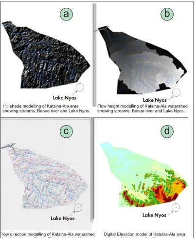
Figure 2: Digital elevation models showing the fracture and drainage patterns, altitude and land use/cover type in Katsina-Ala drainage basin
4.0 RESULTS AND DISCUSSION
The study showed generally a strong correlation between the use of Earth Observation products and field measurements to determine the possibilities of emplacing effective monitoring/early warning systems in an event of the collapse of the Lake Nyos dam. Field and satellite observations revealed the occurrence of numerous fractures and widening of potholes created by the process of erosion on the pyroclastic dam materials. The digital elevation model, flow direction and flow
Many studies have shown that the fault lines are still very active. (Mesmin et al, 2000) and this risk is highly linked to the increasing number of people in this region. The return of the local population, who for the past 20 years had been living in Bua Bua and other resettled localities, has increased the fear of a more deadly disaster (Tazief, 1989, Mesmin et al 2010). Some of the consequences include the depletion of underground water, deforestation and extreme poverty and death, particularly in the event of another gas explosion and flooding. The degasification process which is still in progress points to this fact. The gas emitted during the 1986 explosion mostly flowed across the fault lines; the population which settled along these lines were the most affected. The tectonic activities and the frequency of landslides, especially during the rainy season, constitutes another risk to the population To this effect, the region needs to be constantly surveyed and monitored.(Mesmin et al 2000). Research findings from fieldwork revealed that the survivors of the previous disasters are the poor people who are socially vulnerable to the impacts of the past gas explosion tragedy. Twenty two years after the Lake Nyos Disaster, the survivors have not regained their livelihoods; many of them still have very low resilience and limited coping strategies. This include failed government promises to provide financial and material assistance to disaster victims, provide basic social facilities and ameliorate their housing and living conditions and also the inability to solve other social problems within resettlement zone despite persistent complains (Bang, 2008). While huge sums of money are pumped into the degassing project, the disaster survivors languish in abject poverty in the resettlement camps with a catalogue of numerous social problems that remain unresolved. This unfortunate situation made many of them to go back to their former means of livelihood and settlements such as the sale of cattle, farming and hunting, thus increasing their vulnerability to the Lake Nyos-triggered disaster.
The results from field work and hydrological modelling in a GIS provide viable and reliable information on the dam’s fragility and the vulnerability of the region to floods and erosion.
5.0 CONCLUSIONS
The frequency of occurrence of natural and man-induced hazards and disasters in West Africa sub-region and globally has necessitated the need for constant studies using multi-disciplinary approaches to provide adequate information that will help mitigate the impacts of these hazards and disasters. Poor disaster management policies and practices are partly responsible for the poverty and poor living conditions of the survivors, and this appears to be a key determinant for the social vulnerability of the local population to the effects of the past disaster and subsequent hazards. The management of the disaster associated with lake Nyos gas explosion in 1986 shows a typical example of unfulfilled government’s promises to disaster survivors and a failed policy towards disaster risk reduction. The foregoing therefore informed the need for disaster mitigation planners to alert the governments and other relevant NGOs of their responsibilities to the disaster community ahead of any disaster occurrence (Liebow and Wolfe, 1993).
Lake Nyos holds an enormous volume of CO2 which erupted and kill over 3000 people and livestock at Oku volcanic field in 1986. Integration of satellite data and hydrological models in a GIS combined with social and economic development surveys of the settlement/population around the lake and Katsina-Ala
drainage basin will go a long way in improving the management of future disaster in the region. Early review of available flood hazard information and the integration of complementary flood hazard assessments data will allow planners to foresee and evaluate potential problems related to river hydraulics and floodplain dynamics. The nature of social vulnerability and risk perception of community to hazards is also essential and must be incorporated into disaster risk management policy and practice by the authorities. Then, mitigation measures can be identified to avoid or minimize these hazards; this can be incorporated into the formulation of specific sectoral investment projects.
5.1 References natural hazards in Cameroon two decades after the lake Nyos gas disaster: what future prospect for the displaced disaster victims? Paper presented at the 2008 summer academy for social vulnerability at the united nations university-institute for environment and human security (unu-ehs) in Germany. Blaikie, P.; Cannon, T.; Davis, I.; Wisner, B. (1994): At Risk: Natural hazards, peoples vulnerability, and disasters. London: Routledge.
Freeth, J. and Kay R., (1987): The Lake Nyos gas disaster. Nature, vol 7000, no 325 pp.104 105
Kling, G.; Clark, M.; Compton, R.; Devine, D.; Evans, W.; Humphrey, A.; Tuttle. M. (1987): The 1986 Lake Nyos gas disaster, Cameroon, West Africa. Science, vol 236 pp. 169-175 Krimsky, S.; Golding, D. (Eds) (1992): Social theories of risk. Praeger Publications, CT
Kusakabe, M.; Ohsumi T.; Aramaki S. (1989): The Lake Nyos gas disaster: Chemical and isotopic evidence in waters and dissolved gases from three Cameroonian crater lakes, Nyos, Monoum and Wum. Journal of Volc. and Geoth. Res, vol 39 pp. 167-185
Liebow, E.; Wolfe A. (1993): Communities at risk: communication and choice of environmental hazards. Environ. Prof, vol 15 pp 237–239
Shanklin, E. (1988): Beautiful Deadly Lake Nyos: The Explosion and its Aftermath. Anthropology Today, vol 4 no 1 pp. 2-14 Smith, K. (2001): Environmental Hazards: Assessing risk and reducing disasters. Third Edition Routledge, London.