VERIFICATION REPORT ON GRIEVANCE FROM GREENOMICS
’
PRESS RELEASE
“
ALLEGATION OF APP
’
S NATURAL FOREST MORATORIUM IN THE CONCESSION
AREA OF PT. BUMI MEKAR HIJAU
–
WEST KALIMANTAN
”
VERIFICATION TEAM
1.
Background
On February 1, 2013, APP made a commitment to suspend the conversion of natural forest across its entire supply chain, known as natural forest moratorium as part of its Forest Conservation Policy (FCP). New plantation development activities are only allowed on non forested area which is area that has been assessed to not contain High Conservation Value (HCV) and/or High Carbon Stock (HCS).
On April 4, 2015, Mongabay contacted APP to respond to an allegation of violation in APP’s natural forest moratorium in the concession area of PT Bumi Mekar Hijau (BMH) in West Kalimantan which was stated in a Greenomics press release.
In summary the violation reported is as follows:
Based on analysis of Landsat satellite 8, Greenomics concluded that there has been deforestation carried out by BMH in its concession in West Kalimantan (see picture no 1) after February 1st, 2013.
On June 22, 2014, Landsat satellite showed the area in BMH W-Kalimantan was still green which means it was still forest. But on September 13, 2014, the satellite showed visible change of color to red which according to Greenomics indicated changes in the land cover or deforestation (see picture no 1). Greenomics estimated that the deforestation in BMH W-Kalimantan occurred in an area of 10,000 hectares.
Picture 1: Landsat Satellite 8 analysis taken from Greenomics1 press release
Mongabay also forwarded some coordinates points given by Greenomics2 related to those areas.
1
Source: press release Greenomics 6 April 2015: “More than 10,000 acres of forested deep peatlands lost on APP supplier concession.”
2.
Verification Process
Based on the grievance report, grievance committee conducted following steps:
· A verification team was established
· Verification team conducted documents verification, satellite analysis, field observation and interviewed with related parties.
· Verification team prepared the verification report.
Below are the details of verification actions:
A. Verification Team
The verification team consisted of staffs from Sinarmas Forestry and TFT and accompanied by community members from Lela village. The structure is as follows:
1. Yadi Kuswandana (TFT)
The verification was undertaken from April 4 – May 1, 2015, with following details:
1. 4 s/d 6 April 2015 : Field verification and interviews
2. 6 s/d 10 April 2015 : Documents verification and satellite analysis 3. 10 April 2015 : Data verification at HQ office
4. 22 April 2015 : Other supporting data verification 5. 27 April – 1 Mei : Field verification
C. Location
Verification was conducted at BMH office in Pontianak and HQ office in Jakarta, and field verification in the locations mentioned in Greenomics’ press release.
D. Verification Method
1. Verification of licensing legality and other relevant key documents
2. Plotting the area mentioned in the Greenomics’ press release into BMH’s Work Base Map.
4. Verifikasi RPBBI Mill APP tahun 2013 dan 2014.
Verification of APP mills Industrial Raw Material Acquisition Plan (RPBBI) for the years 2013 and 2014.
5. Visited locations stated in the Greenomics report and coordinate points forwarded by Mongabay, conducted field observation and took photographs of the area.
6. Interviewed relevant parties.
7. Some interrelated evidences identified as findings.
8. Findings that are interrelated and/or have logical connection are used to develop conclusions.
9. The development of recommendations refers to the established conclusions and APP’s FCP.
3.
Conclusions
Details of verification outcome can be found in the appendix.
A. Verification team has confirmed that the area stated in the Greenomics report is block I of BMH concession in West Kalimantan which was given by the Ministry of Forestry under September 2014 (see Picture no 2) which showed there were fires in the concession which was estimated to affect around 8,000 hectares as stated in Greenomics report.
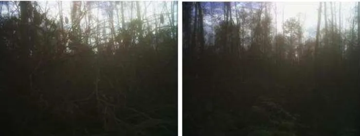
· Field verification and observation in the area that experienced land cover changes described in the Greenomics’ report, revealed that the area has now been covered with new shrubs aged around 6 to 10 months (see Picture no 3)
· BMH West Kalimantan’ operational documents (RKUPHHK and RKT) showed that no land preparation activities and no infrastructure development were carried out in those area because BMH has not yet secured approval from surrounding communities.
· Based on the field condition with surrounding communities, BMH has taken the decision to not to develop the FMU in West Kalimantan. BMH is in the process to return the concession area to the Ministry of Environment & Forestry (KLHK).
4.
Recommendations
A. BMH West Kalimantan shall carry out efforts to address and prevent the occurrence of further forest fires in the area.
B. APP shall provide clarification to stakeholders about the relationship between BMH West Kalimantan and BMH East Kalimantan.
APPENDIX 1. VERIFICATION RESULT
PT Bumi Mekar Hijau (BMH) conducted verification on the Greenomics allegation of clearing 10,000 ha natural forest in Block I of its West Kalimantan concession.
1.
Verification of Documents
A. Verification of concession permit, operating license, and other relevant documents.
The following table describes the chronology of PT BMH in obtaining concession permit and operating license.
Year Description
2006 · BMH obtained environmental feasibility permit from the Governor of West Kalimantan under West Kalimantan Governor Decree No. 788/2006 dated 30 November 2006.
2007 · BMH obtained SK IUPHHK-HT (Minister of Forestry Decree) No. 179/Menhut-II/2007 dated 1 May 2007 for an area of 25,580 ha, which is located in Sambas district and Singkawang administrative. The area in Sambas district, namely block I, consists of 3 sub district: Teluk Keramat, Jawai and Tangaran. Sambas district with reference number 529/641/Hutbun/IV/2006 dated 16 June 2006.
Bupati Sambas issued the Recommendation letter based on the pressure of Jawai community regarding the following:
- Most of BMH areas in Jawai sub district have been converted into community plantations and the community needed to expand their plantation areas.
- There is no clarity between the partnership scheme with the community and BMH’s plan to manage HTI areas for 100 years, which would reduce the community’s land area.
Following up this situation, on 26 July 2008, PT BMH conducted following actions:
- BMH communicated with Secretariate General of STSD Sambas district to suggest holding a dialog with STSD or Jawai community to seek solution for the HTI plantation of BMH.
Year Description
community demand to revoke BMH operating permit. The community rejected and demonstrated against the company at Jawai sub-district meeting hall therefore the socialisation was postponed.
2009 · BMH obtained 2009 Work Plan (RKT 1) under a Decree (SK) number Decree number 7/VI-BUHT/2012 dated 15 February 2012.
· 2012 Work Plan (RKT 4) under a Decree number 312/Dishut-license to the Ministry of Environment and Forestry on 15 May 2015 under a letter number 01/BMH/JKT/IV/2015.
Although BMH obtained the operating license since 2009 in the form of work chart and received approval for its RKT from the Ministry of Forestry in 2010, PT BMH never realised the RKT to prepare the land nor develop infrastructure. This is due to the absence of consent from the community around PT BMH areas for the HTI development plan.
B. Overlay plots between 2009 Work Plan (RKT 1), SK No. 08/Dishut-IV/Rhh/2009 dated 13 January 2009 and the coordinate points forwarded by Mongabay.
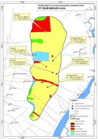
Figure 2: Plotting of Greenomics 4 coordinate points on PDK BMH in West Kalimantan Point No. 1, 2, 3 and 4 (red color)
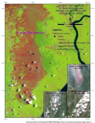
C. Hot spots from June to August 2014
Since 2006 until 2015, BMH has not carried out land preparation or convert natural forest in its West Kalimantan concession. In order to find out the cause of open area as indicated by landsat, we tracked down hot spots within BMH that was recorded by TERRA MODIS and AQUA MODIS from June to August 2014 and found many hotspots as follow:
Hotspots in BMH (June – August 2014)
No Month No of hot spots 1 June 2014 23 2 July 2014 169 3 August 2014 3 Source: Firms data from Nasa
Based on calculation using landsat images which was overlaid with BMH work base map, we found approximately ± 7780,5 ha areas were affected by fire.
Hotspots and burned areas distribution is shown in figure 3 below.
Source : Citra landsat satellite 8 Path raw 12259 recorded on September 13, 2014 ; Boundary concession of BMH; Hot Spot from Firm NASA
D. Wood supply from BMH to APP mills
APP mills sources pulp from several suppliers, e.g. Forest Management Unit (FMU) in Sumatera and Kalimantan. One of the suppliers is PT Bumi Mekar Hijau (PT BMH) in South Sumatra, which belong to the same group as BMH West Kalimantan.
Until now, logs originated from FMUs in West Kalimantan are sent to Indah Kiat Pulp & Paper (IKPP) mill in Perawang, Riau. RPBBI assessment of IKPP was carried out to confirm whether there are logs delivered from BMH West Kalimantan, in relation to deforestation claim mentioned in Greenomics press release.
Based on RPBBI in 2013 and 2014, BMH West Kalimantan is not registered in RPBBI IKPP Perawang. This proved that APP has never received logs from BMH in West Kalimantan.
2.
Field verification
Field verification was carried out in areas, where based on Greenomics press release, there was forest clearing indication,. The main objectives are the four coordinate points provided by Greenomics.
a. Accessibility to coordinate points
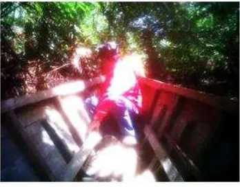
Since 2007 until the publication of Greenomics press release, BMH has not developed road in the area where Department of Forestry has given the license. BMH area can be accessedby walking into the forest and/or by using a boat through small rivers. At the time this verification was carried out, both sides of the river have been overgrown with shrubs.
b. Verification at Grievance location
Verification team had conducted field verification to BMH areas but they cannot reach the coordinates provided by Greenomics due to the absence of infrastructure. The nearest location that can be reached is survey point 2 and survey point 3 (See blue dots in Figure 2). The actual conditions can be seen in Figure 5 and 6 below.
Figure 5: Photos at survey point 2, with coordinate X 109° 9’ 26.300” Y 1° 23’ 29,600
In their attempt to reach the second coordinate from Greenomics, the verification team made it to the nearest location i.e. survey point 2 (Figure 2). Due to lack of access road , the verification team had to walk to reach the location at survey point 2 but severe conditions made it difficult for them to continue (burned forest, dried dead trees, covered with burned forest litter, small trees collapsed due to rotting and ferns in several location) .
Figure 6: Photos at survey point 3, with coordinate X 109° 9’ 2.200” Y 1° 25’ 0,200”
In their attempt to reach the third coordinate, the verification team made it to the nearest location i.e. survey point 3. To reach this location, tim used a boat to cross small rivers and continued by walking for 3 km. The team stopped at the survey point location (Figure 6) due to severe conditions to proceed. The area at survey point 3 comprises of burned forest, dried dead trees, cover with burned forest litter and overgrown shrubs.
Palm and rubber plantation belonging to Sungai Baru villagers, Teluk Keramat sub district within BMH area.
Coconut trees belong to Sarang Burung Kolam villagers, Jawai sub district within BMH area.