OGC Discussion Paper OGC 05-115
Open Geospatial Consortium Inc.
Date: 2006-02-15
Reference number of this OGC® document: OGC 05-115
Version:0.0.9
Category: Discussion Paper
Editor: Joe Lewis
GeoVideo Web Service
Copyright © 2006 Open Geospatial Consortium. All Rights Reserved To obtain additional rights of use, visit http://www.opengeospatial.org/legal/
Warning
This document is not an OGC Standard. It is distributed for review and comment. It is subject to change without notice and may not be referred to as an OGC Standard. Recipients of this document are invited to submit, with their comments, notification of any relevant patent rights of which they are aware and to provide supporting documentation.
Document type: OGC Discussion Paper
Contents
i. Submitting organizations ...6
ii. Document contributor contact points ...6
iii. Revision history...7
iv. Changes to the OpenGIS® Abstract Specification ...7
v. Future work...7
Foreword...8
Introduction...9
1 Scope...9
2 Normative references...9
4 Terms and definitions ...10
4.1 Stream ...10
4.2 Feed ...10
4.3 Web Service ...10
4.4 SOAP (Simple Object Access Protocol) ...10
4.5 Media File ...10
4.6 Symbols (and abbreviated terms)...10
4.7 UML notation ...11
4.8 Document terms and definitions...11
5 Overview of GeoVideo Web Service (GVS)...11
5.1 The Web Service ...11
5.2 GVS components...11
6 The GVS Database...14
6.1 List of tables that are used by GVS...15
7 GVS Web Service Interface ...18
7.1 GVS and Client Proxy Classes...18
7.2 Operations provided by GVS Web Service ...18
7.2.1 Definition of GVS Web Service operations ...18
7.3 Description of GVS Client Proxy Classes ...20
7.3.1 GVS Client Proxy Class Data Members ...23
7.4 GVS Data Encapsulation...29
7.4.1 GVS Date Time Location String...29
7.4.2 GVS Raw String...31
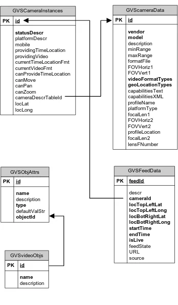
7.5 GVS Database Schema ...32
7.5.1 GVS GVScameraData Table ...32
7.5.2 GVS GVSCameraInstances Table ...33
7.5.3 GVS GVSFeedData Table...34
7.5.4 GVS GVSObjAttrs Table...35
Figures Page
Tables Page
Figure 1. Overview of GVS... 13
Figure 2. GVS tables. ... 17
Figure 3- UML diagram for main GVS Objects... 21
Figure 4 UML Diagram for GVS Query Objects ... 22
Preface
This document defines a Web Services interface for a GeoVideo Web Service. This document is an Interoperability Program Report from the OGC Web Services Phase 3 (OWS-3) interoperability initiative.
Suggested additions, changes, and comments on this draft report are welcome and
encouraged. Such suggestions may be submitted by OGC portal message, email message, or by making suggested changes in an edited copy of this document.
The changes made in this document version, relative to the previous version, are tracked by Microsoft Word, and can be viewed if desired. If you choose to submit suggested changes by editing this document, please first accept all the current changes, and then make your suggested changes with change tracking on.
i. Submitting
organizations
The following organizations submitted this document to the Open Geospatial Consortium Inc.
Intergraph Corporation, Huntsville, Alabama
ii.
Document contributor contact points
All questions regarding this document should be directed to the editor or the contributors:
Contact Company Joe Lewis Intergraph
Corporation
Gene Grindstaff Intergraph Corporation
iii. Revision
history
Date Release Editor Primary clauses modified
Description
25-oct-2005 0.0.0 Grindstaff 7.4 Added closed caption encoding description and database table description
28-Jan-2006 0.0.9 Carl Reed various Fix copyright, minor edits, etc.
iv.
Changes to the OpenGIS
®Abstract Specification
The OpenGIS® Abstract Specification does not require changes to accommodate the technical contents of this document.
v. Future
work
Improvements in this document are desirable to provide code examples in both C# and Java, of consuming the GVS web service.
Examples of consuming GVS by sending\receiving explicit SOAP XML requests\responses could also be provided.
Foreword
Attention is drawn to the possibility that some of the elements of this document may be the subject of patent rights. The Open GIS Consortium Inc. shall not be held responsible for identifying any or all such patent rights.
— This document was prepared solely by members of the OGC; — This document does not replace or modify any other document;
Introduction
A GeoVideo Web Service (GVS) is a web service that facilitates the viewing of live and/or archived feeds from video cameras. The feeds may be composed of:
• A video stream
• Textual data in a caption stream (e.g. GPS data, camera states and characteristics, custom XML data, such as SensorML\TML)
• A combination of a video stream and associated textual data
The video streams of the feed may be viewed in the Windows Media Player. The textual data is extracted through scripting events that are generated as the caption stream is processed and displayed by the Windows Media Player.
GeoVideo Service
1 Scope
This OpenGIS® document is applicable to anyone who would want to implement a GeoVideo Web Service, or interface with its operations.
This document describes the operations provided by GeoVideo Web Services (GVS), usage and schema of the database required to store information about its logical components (e.g. feeds and cameras). Supporting documentation include a WSDL document describing the Web interface UML diagrams, and examples of HTTP Get Requests\Responses for consuming GVS web.
Included in the technical description of GVS is the generation and usage of GVS client proxy objects, which simplify the client interface to GVS.
This document also describes a methodology for using GVS as an enabler for real-world video-centric security solutions.
2 Normative references
amendments to, or revisions of, any of these actions do not apply. For undated references, the latest edition of the normative document referred to applies.
OGC 03-008r1, OGC Web Services Common Implementation Specification, October 2003
3 N/A
4 Terms and definitions
For the purposes of this specification, the definitions specified in Clause 4 of the OGC Web Services Common Implementation Specification [OGC 03-008r1] shall apply. In addition, the following terms and definitions apply.
4.1 Stream
The output from a video camera, which may be either video (successive images) or textual (e.g. GPS data)
4.2 Feed
A live or archived stream of video and\or textual data, in a format that allows the feed to be displayed in a media player.
4.3 Web Service
A web server application that exposes operations, which a web client can invoke to perform specific tasks
4.4 SOAP (Simple Object Access Protocol)
The format of XML messages that are sent between the web client and web service during the execution of web service methods
4.5 Media File
A file containing a video stream
4.6 Symbols (and abbreviated terms) Some frequently used abbreviated terms:
GVS GeoVideo Web Service
WSDL Web Service Definition Language
OGC Open GIS Consortium
UML Unified Modeling Language
XML Extended Markup Language
4.7 UML notation
Most diagrams that appear in this specification are presented using the Unified Modeling Language (UML) static structure diagram, as described in Subclause 5.2 of [OGC 05-008].
4.8 Document terms and definitions
This document uses the specification terms defined in Subclause 5.3 of [OGC 04-016r2].
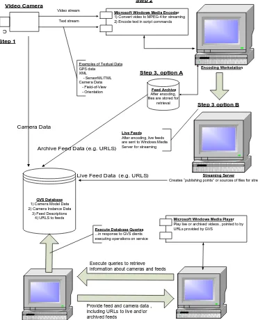
5 Overview of GeoVideo Web Service (GVS)
5.1 The Web Service
GVS is a web service that facilitates the viewing of live and\or archived feeds from video cameras. The feeds may be composed of:
• A video stream
• Textual data in a caption stream (e.g. GPS data, camera states and characteristics, custom XML data, such as SensorML\TML)
• A combination of a video stream and associated textual data
The video streams of the feed may be viewed in the Windows Media Player. The textual data is extracted through scripting events that are generated as the caption stream is processed and displayed by the Windows Media Player.
5.2 GVS components The main components of GVS are:
• Video cameras that provide video streams and textual data • Microsoft Window Media Encoder, that:
o Converts camera video format into MPEG-4
o Encode textual data as scripts commands in caption stream
o Either stores encoded files as archives, or sends them to Windows Media Server as live streams
• Microsoft Windows media server, which provides clients with “publishing points” or sources of live streaming media files, i.e. real-time video feeds which are being encoded by Microsoft Window Media Encoder
• GVS Database, that contains data about feeds and cameras, that GVS Web Services need to satisfy its clients’ queries, and locate URLs of requested feeds • GVS Web Services, that provide an interface to its clients for retrieving data from
the GVS database
• GVS Client, that queries the GVS Database (via GVS Web Services) to obtain information about cameras and feeds, and URLs for accessing the feeds • Windows Media Player (embedded in the GVS client) that plays videos and\or
Figure 1. Overview of GVS
C
Video Camera
Microsoft Windows Media Encoder
1) Convert video to MPEG-4 for streaming 2) Encode text in script commands Video stream
Text stream
Examples of Textual Data GPS data
Creates “publishing points” or sources of files for streaming
Feed Archive
After encoding, files are stored for
retrieval
Step 1
Step 2
Step 3, option A
Step 3 option B
Live Feeds
After encoding, live feeds are sent to Windows Media Server for streaming
GVS Database
1) Camera Model Data 2) Camera Instance Data
3) Feed Descriptions 4) URLS to feeds
GVS Web Service
Provides a web service interface to consumers of service
GVS Client
Consumes GVS services
Camera Data
Archive Feed Data (e.g. URLS)
Live Feed Data (e.g. URLS)
Execute Database Queries
...in response to GVS clients executing operations on service
Execute queries to retrieve information about cameras and feeds
Microsoft Windows Media Player
Play live or archived videos , pointed to by URLs provided by GVS
6 The GVS Database
Information about camera types, instances of cameras and their associated feeds are stored in the GVS database. Through the operations exposed by GVS an end-user may retrieve cameras, and\or feeds with properties meeting specific physical, spatial, or temporal data.
An example of such a query would be “return all the archived feeds with the rectangle bounded by 38.01202 N, -71.08812 W and 37.973 N, -71.06 W from cameras with zoom capability, between the 10:30 a.m. and 12:30 p.m. on Aug 3, 2004.
6.1 Summary of GVS queries
Through the GVS interface, a consumer of its services can search for videos that a) start with a given time range
b) covers a given time range c) starts before a given time d) starts after a given time
e) starts with a given time range within a given area of interest (AOI) f) covers a given time range within a given AOI
g) starts before a given time within a given AOI h) starts after a given time within a given AOI i) starts with a given time range within a given AOI
j) starts with a given time range within a given AOI, and has specific feed and\or camera characteristics
k) covers a given time range within a given AOI, and has specific feed and\or camera characteristics
l) starts before a given time within a given AOI, and has specific feed and\or camera characteristics
m) starts after a given time within a given AOI, and has specific feed and\or camera characteristics
n) starts with a given time range within a given AOI, and has specific feed and\or camera characteristics
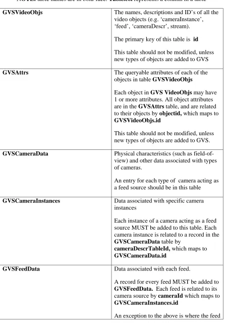
6.1 List of tables that are used by GVS.
Table 1. Description and Usage of GVS tables
NOTE: table names are in bold-face. Table.col represents a column in a table
GVSVideoObjs The names, descriptions and ID’s of all the
video objects (e.g. ‘cameraInstance’, ‘feed’, ‘cameraDescr’, stream). The primary key of this table is id This table should not be modified, unless new types of objects are added to GVS
GVSAttrs The queryable attributes of each of the
objects in table GVSVideoObjs
Each object in GVS VideoObjs may have 1 or more attributes. All object attributes are in the GVSAttrs table, and are related to their objects by objectid, which maps to GVSVideoObjs.id
This table should not be modified, unless new types of objects are added to GVS.
GVSCameraData Physical characteristics (such as field-of-
view) and other data associated with types of cameras.
An entry for each type of camera acting as a feed source should be in this table
GVSCameraInstances Data associated with specific camera
instances
Each instance of a camera acting as a feed source MUST be added to this table. Each camera instance is related to a record in the GVSCameraData table by
cameraDescrTableId, which maps to GVSCameraData.id
GVSFeedData Data associated with each feed.
A record for every feed MUST be added to GVSFeedData. Each feed is related to its camera source by cameraId which maps to GVSCameraInstances.id
contains a caption stream with spatial-temporal data for multiple cameras. In that case, cameraId is 0.
7 GVS Web Service Interface
7.1 GVS and Client Proxy Classes
Instead of using HTTP GET with key-value pair encoding, clients consume GVS Web Services via the SOAP protocol, encapsulated by client proxy classes. The classes are generated from the WSDL file, by tools specific to the client’s development environment. The client code does not have to include functionality for creating\sending the XML SOAP requests to the server, or requesting\decoding SOAP responses. Instead, the client creates instances of proxy objects, and executes methods on the GVS Server by calling methods on the objects. The proxy objects already encapsulate all of the logic needed to communicate with the server, via SOAP.
All of the proxy objects are described in detail in section 7.3 of this document.
7.2 Operations provided by GVS Web Service
Following is a list of all the functions in the GVS Web Service Interface. Instead of executing these operations via HTTP Get with key-value pair encoding, a consumer of GVS creates an object that encapsulates - or acts as a proxy for – GVS Web Services, then calls methods on that object.
Example (C#)
_GVS = new Service(); //creates a GVS service object
CObjectDescrs[] _objectDescrs = _GVS.GetGVSObjectDescrs();
In the code above, after a GVS service object (GVS) is created in the client code, the operation GetGVSObjectDescrs() (described below in section 7.2.1) is executed and returns a list of GVS objects called CObjectDescrs (also described in section 7.2.1). The GVS objects become defined and usable to client code, after the GVS Web Services WSDL document is processed by the client development environment. In Microsoft Visual Studio for example, the WSDL document is processed by providing a URL to its location, which is then added to the development environment as a “Web Reference”. A GVS namespace is then created, which contains all of the GVS objects described in section 7.2.1).
7.2.1 Definition of GVS Web Service operations
Name: GetCapabilities
ReturnValue: String – the XML instance document
Arguments:
Name Data Type Purpose
acceptVersions string
Sections string
UpateSequence string
AcceptFormats string
Name: GetGVSObjectDescrs
Purpose: Returns a list of descriptions for all the objects known to GVS. Each object contains a list of attributes, via a property called '_attributes'.
ReturnValue: CObjectDescr[] – an array of CObjectDescr objects (see section 7.3) Arguments: - none
Name: GetFeedsFromIds
Purpose: Returns a list of CFeed objects (see section 7.3) from a list of feed ids ReturnValue: CFeed[] – an array of CFeed objects
Arguments:
Name Data Type Description
FeedIds int [] List of feed ids.
Name: GetFeedsFromQuery
Purpose: Returns the list of CFeed objects (see section 7.3 which meet the query criteria specified in the CQueryObj object.
ReturnValue: CFeed[] – an array of CFeed objects
Arguments:
Name Data Type Description
queryObject CQueryObj Object containing criteria
for query
Name: GetCamerasFromQuery
Purpose: Returns the list of CCamera objects (see section 7.3 which meet the query criteria specified in the CQueryObj object.
ReturnValue: CCamera [] – an array of CCamera objects
Arguments:
Name Data Type Description
queryObject CQueryObj Object containing criteria
7.3 Description of GVS Client Proxy Classes
In this section is a description of all the GVS client proxy objects.
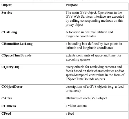
Table 2. Overview of Client Proxy Classes
Object Purpose
Service The main GVS object. Operations in the
GVS Web Services interface are executed by calling corresponding methods on this proxy object
CLatLong A location in decimal latitude and
longitude coordinates.
CBoundBoxLatLong a bounding box defined by two points in
latitude and longitude coordinates
CSpaceTimeBounds extents\contraints of space and time, for
executing queries
CQueryObj query criteria for retrieving cameras and
feeds based on their characteristics and\or spatial-temporal constraints in the form of CSpaceTimeBounds objects
CObjectDescr descriptions of a GVS objects (e.g. a feed
or camera)
CAttrs attributes of each GVS object
CCamera a video camera
Figure 3- UML diagram for main GVS Objects
+CAttrs()
+CAttrs(in name : string, in description : string, in type : string, in defaultValStr : string) +_name : string +_endTimeStr : string +_feedState : string +_currentVideoFormat : string +_currentTimeLocationFormat : string +_nowProvidingVideo : bool +_nowProvidingTimeLocation : bool +_cLocation : CLatLong
+_mobile : bool +_platformDescr : string +_statusDescr : string
+CObjectDescr(in name : string, in description : string, in id : int) +id() : int
+_name : string +_description : string -_id : int
Figure 4 UML Diagram for GVS Query Objects
+DateLessThanOrEqual(in Date1 : DateTime, in Date2 : DateTime) : bool +DateGreaterThanOrEqual(in Date1 : DateTime, in Date2 : DateTime) : bool +Convert2DateTimeStructs() : bool
+SetBoundBoxCheckFlag() : bool
-IsBoundBoxEnclosed(in bndBoxToTest : CBoundBoxLatLong, in bndBoxEnclosing : CBoundBoxLatLong) : bool -IsLocationInBoundBox(in location : CLatLong) : bool
+GetFeedsFromSpaceTimeQuery(in feedObjectsToQuery : ArrayList, inout arrFeedsMeetingCriteria : ArrayList) +GetCamerasFromSpatialQuery(in camerasToQuery : ArrayList, inout camerasMeetingCriteria : ArrayList) +_boundBoxLatLong : CBoundBoxLatLong
+_beforeStart : bool +_afterEnd : bool
+_betweenStartEndTimes : bool +_startDateTimeUTCStr : string -_doDateTimeCompare : bool -_startDateTime : DateTime
CQueryObj contains the
criteria used to retrieve GVS objects from a query
Figure 5 UML Object for GVS Service Object
+Service()
-InitializeComponent() #Dispose(in disposing : bool)
+GetCapabilities(in acceptVersions : string, in Sections : string, in updateSequence : string, in acceptFormats : string) : string +GetGVSObjectDescrs () : CObjectDescr[]
+GetStrmCameraCoordsInRect(in b : CBoundBoxLatLong, in criteria : string) : string +GetFeedsFromIds(in FeedIds : int[]) : CFeed[]
+GetFeedsFromQuery(in queryObject : CQueryObj) : CFeed[] +GetCamerasFromQuery(in queryObject : CQueryObj) : CCamera[]
-sqlConnection1_InfoMessage(in sender : object, in e : SqlInfoMessageEventArgs) -_GVSDatabase : CGVSDatabase
-oleDbConnection1 : OleDbConnection -_objectDescrs : CObjectDescr[] -components : IContainer = null
Service
7.3.1 GVS Client Proxy Class Data Members
Following is a list of all the GVS Client Proxy Classes, along with their data types and descriptions.
Class: CFeed
Data Member Type Description
_feedDescription: String Description of feed
_iFeedId: int Feed id
_boundBoxLatLong: CBoundBoxLatLong
(GVS object)
Bounding box object containing spatial extents of feed
_locationURL: string URL of feed
_archived: Boolean Whether or not feed is
archived
_hasStreamOfLocationTime: Boolean Feed has textual
spatial\temporal data
_camera: CCamera (GVS object) The camera object that is the feed source
_startTimeStr: String Date\time that feed started
_endTimeStr: String Date\time that feed ended
_feedState: String Not used
_source: String If “boundingBox” then
this is a feed containing spatial-temporal data of cameras moving within the area defined by _boundBoxLatLong
Class: CCamera – represents a GVS camera
Data Member Type Description
_cameraId int Camera id
_canZoom Boolean Has zoom capability
_canPan Boolean Has pan capability
_canMove Boolean Can move (pitch, roll,
yaw)
_canProvideTimeLocationt Boolean Can provide textual
spatial-temporal data
_currentVideoFormat String Format of video (e.g.
MPEG-2)
_currentTimeLocationFormat String Format of
spatial-temporal data (e.g. GPS
_nowProvidingVideo Boolean Currently providing
video feed
_nowProvidingTimeLocation Boolean Currently providing
spatial-temporal data
_cLocation CLatLong A location object,
camera
_mobile Boolean Camera is moving
_platformDescr String Description of platform
_statusDescr String Status
_cameraDescriptor CCameraDescriptor Object containing a
description of camera
Class: CAttrs – attributes of a GVS Object
Data Member Type Description
_name string Name of object
_description string Description of object
_type string Type of object
Class: CObjectDescr – describes GVS Objects
Data Member Type Description
_name string descr
_description string descr
_id descr
_attributes CAttrs[] descr
Class: CCameraDescriptor – describes GVS Camera Objects
Data Member Type Description
_vendor String vendor
_model String model
_id int Unique row id
_description String Description of camera
_minRange double Minimum range
_maxRange double Maximum range
_formatFile String descr
_FOVHoriz1 double Horizontal field-of-view 1
_FOVVert1 double Vertical field-of-view 1
_videoFormatTypes String Video formats supported
(colon-delimited)
_geoLocationTypes String Textual spatial-temporal
data format (e.g. GPS) colon-delimited
_capabilitiesText String Additional capabilities text
_profileName String Name of encoding profile file
_platformType String Type of platform
_focalLen1 double Focal length 1
_FOVHoriz2 double Horizontal field-of-view 2
_FOVVert2 double Vertical field-of-view 2
_profileLocation String Location of profile file
_focalLen2 double Focal length 2
_lensFNumber double Lens f/number
Struct: CLatLong – describes a location in decimal latitude and longitude
Data Member Type Description
_latitude float
_longitude float
Struct: CBoundBoxLatLong describes a bounding-box location in decimal latitude and longitude.
Data Member Type Description
_latitudeTopLeft float Latitude at top left corner of
bounding box
_longitudeTopLeft float Longitude at top left corner
of bounding box
_latitudeBotRight float Latitude at bottom right
corner of bounding box
_longitudeBotRight float Longitude at bottom right
Class: CQueryObj - stores query criteria for retrieving data and feeds from GVS database
Data Member Type Description
_objectName string Name of object –currently
ignore
_criteria string String containing ‘where
clause’ used in query, e.g “isLive = 1” to query for live feeds
_maxObjects int Currently unused
_spaceTimeBounds CSpaceTimeBounds (object)
Stores spatial-temporal extents of query (see below)
Class: CSpaceTimeBounds – stores spatial-temporal extents for queries
_boundBoxLatLong: CBoundBoxLatLong (object)
Bounding box that query is based on
_beforeStart: Boolean Query for date\time before
_startDateTimeUTCStr
_afterEnd: Boolean Query for date\time after
_endDateTimeUTCStr
_betweenStartEndTimes: Boolean Query for times between
_startDateTimeUTCStr and_endDateTimeUTCStr
_startDateTimeUTCStr: String Start date\time that query is
based on
_endDateTimeUTCStr: String End date\time that query is
based on
_location: CLatLong (object) Store a location
_instructionsEx: String Currently unused
_spansStartEndTimes: Boolean Query for date\time extent
_startDateTimeUTCStr and_endDateTimeUTCStr
_doBoundBoxCheck: Boolean Use bounding box in query
_doDateTimeCompare: Boolean Use date\time criteria in
query
7.4 GVS Data Encapsulation 7.4.1 GVS Date Time Location String
The following information must be encoded in the Closed Caption field of the video stream for the GeoVideo Service:
1. Date 2. Time
3. A closed polygon describing either the camera view cone when looking over the horizon, or quadrangle that shows the area of interest when looking down on the ground.
The date shall be encoded in ISO date/time format, and should take the ISO format of year-month-day hour:minute:seconds, or 2005-07-05 13:00:00 zulu.
Source
Extent at plus half angle
Extent at minus half angle View
Direction
Three Point Polygon to describe View Cone
If the camera’s view cone intersects with the ground, then the first point shall be the source location of the camera expressed in LAT LON decimal degrees. The remaining five points will describe the intersection of the view cone in LAT LON decimal degrees.
Source
Intersection with ground
Intersection with ground View
Direction
Five Point Polygon to describe View Cone
default value of 60 degrees will be used. If the vertical view angle is not specified, a default value of 45 degrees will be used. If the camera is mobile, and the viewing direction is not specified, then successive points will be used to calculate the viewing direction. If the camera is not mobile and the viewing direction is not specified, it will default to zero degrees. If the roll and pitch of the camera are not specified, they will default to zero degrees. If the camera’s altitude is not specified, then a default value of sea level will be assumed. Since the terrain elevation is not available to the GVS, all terrain is assumed to be at sea level.
Encoding Format for Date Time Location:
The encoding of the data shall be the following simple line of text:
$GVDTL 0, 2005-07-05T13:55:07, 3, 34.6996866,-86.6883722, 34.6996602,-86.6880433, 34.6994416,-86.6882358, \n
Wher e t he above is:
GeoVideo Dat e Tile Locat ion I dent ifier and ver sion, Year - m ont h- day
hour : m inut e: seconds ZULU, num ber of point s, lat , lon, lat , lon, lat , lon…, new line
7.4.2 GVS Raw String
The second line of the encoded string shall be the raw of the GPS, IMU, and camera parameters. It is the information used to calculate the first string and is provided so that the client can do more detailed mapping of the camera to terrain for such purposes as roto-scoping video.
Encoding Format for RAW string:
The encoding of the data shall be the following simple line of text:
$GVRAW 0, 2005-07-05T13:55:07,
34.6996866,-86.6883722,673.5,0.0,-15.0,270.0,60.0,40.0,30.0 This string consists of the following fields:
$GVRAW 0 - A GeoVideo identifier and version number 2005-07-05T13:55:07 - Date and Zulu Time in ISO format
34.6996866,-86.6883722,673.5, - Camera location in lat, lon, elevation in decimal degrees and meters
7.5 GVS Database Schema
The following is a description of the tables used in the GVS database.
7.5.1 GVS GVScameraData Table
if exists (select * from dbo.sysobjects where id =
object_id(N'[gvsuser].[GVScameraData]') and OBJECTPROPERTY(id, N'IsUserTable') = 1)
drop table [gvsuser].[GVScameraData] GO
CREATE TABLE [gvsuser].[GVScameraData] (
[vendor] [varchar] (50) COLLATE SQL_Latin1_General_CP1_CI_AS NOT NULL ,
[model] [varchar] (50) COLLATE SQL_Latin1_General_CP1_CI_AS NOT NULL ,
[id] [int] NOT NULL ,
[description] [varchar] (100) COLLATE SQL_Latin1_General_CP1_CI_AS NULL ,
[minRange] [float] NULL , [maxRange] [float] NULL ,
[formatFile] [varchar] (150) COLLATE SQL_Latin1_General_CP1_CI_AS NULL ,
[FOVHoriz1] [float] NULL , [FOVVert1] [float] NULL ,
[videoFormatTypes] [varchar] (50) COLLATE SQL_Latin1_General_CP1_CI_AS NOT NULL , [geoLocationTypes] [varchar] (50) COLLATE SQL_Latin1_General_CP1_CI_AS NOT NULL ,
[capabilitiesText] [varchar] (150) COLLATE SQL_Latin1_General_CP1_CI_AS NULL ,
[capabilitiesXML] [varchar] (150) COLLATE SQL_Latin1_General_CP1_CI_AS NULL ,
[profileName] [varchar] (150) COLLATE SQL_Latin1_General_CP1_CI_AS NULL ,
[platformType] [varchar] (100) COLLATE SQL_Latin1_General_CP1_CI_AS NULL ,
[focalLen1] [float] NULL , [FOVHoriz2] [float] NULL , [FOVVert2] [float] NULL ,
[profileLocation] [varchar] (100) COLLATE SQL_Latin1_General_CP1_CI_AS NULL ,
[focalLen2] [float] NULL , [lensFNumber] [float] NULL ) ON [PRIMARY]
7.5.2 GVS GVSCameraInstances Table
if exists (select * from dbo.sysobjects where id =
object_id(N'[gvsuser].[GVSCameraInstances]') and OBJECTPROPERTY(id, N'IsUserTable') = 1)
drop table [gvsuser].[GVSCameraInstances] GO
CREATE TABLE [gvsuser].[GVSCameraInstances] (
[statusDescr] [varchar] (100) COLLATE SQL_Latin1_General_CP1_CI_AS NOT NULL ,
[platformDescr] [varchar] (100) COLLATE SQL_Latin1_General_CP1_CI_AS NULL ,
[mobile] [bit] NULL ,
[providingTimeLocation] [bit] NULL , [providingVideo] [bit] NULL ,
[currentTimeLocationFmt] [varchar] (50) COLLATE SQL_Latin1_General_CP1_CI_AS NULL ,
[currentVideoFmt] [varchar] (50) COLLATE SQL_Latin1_General_CP1_CI_AS NULL ,
[canProvideTimeLocation] [bit] NULL , [canMove] [bit] NULL ,
[canPan] [bit] NULL , [canZoom] [bit] NULL , [id] [int] NOT NULL ,
[cameraDescrTableId] [int] NULL , [locLat] [float] NULL ,
7.5.3 GVS GVSFeedData Table
if exists (select * from dbo.sysobjects where id =
object_id(N'[dbo].[GVSFeedData]') and OBJECTPROPERTY(id, N'IsUserTable') = 1)
drop table [dbo].[GVSFeedData] GO
CREATE TABLE [dbo].[GVSFeedData] ( [feedId] [int] IDENTITY (1, 1) NOT NULL ,
[descr] [varchar] (200) COLLATE SQL_Latin1_General_CP1_CI_AS NULL , [cameraId] [int] NOT NULL ,
[locTopLeftLat] [float] NOT NULL , [locTopLeftLong] [float] NOT NULL , [locBotRightLat] [float] NOT NULL , [locBotRightLong] [float] NOT NULL , [startTime] [datetime] NOT NULL , [endTime] [datetime] NOT NULL ,
[isLive] [char] (1) COLLATE SQL_Latin1_General_CP1_CI_AS NOT NULL , [feedState] [varchar] (50) COLLATE SQL_Latin1_General_CP1_CI_AS NULL ,
[URL] [varchar] (100) COLLATE SQL_Latin1_General_CP1_CI_AS NULL , [source] [varchar] (50) COLLATE SQL_Latin1_General_CP1_CI_AS NULL ) ON [PRIMARY]
7.5.4 GVS GVSObjAttrs Table
if exists (select * from dbo.sysobjects where id =
object_id(N'[gvsuser].[GVSObjAttrs]') and OBJECTPROPERTY(id, N'IsUserTable') = 1)
drop table [gvsuser].[GVSObjAttrs] GO
CREATE TABLE [gvsuser].[GVSObjAttrs] (
[name] [varchar] (100) COLLATE SQL_Latin1_General_CP1_CI_AS NOT NULL ,
[description] [varchar] (200) COLLATE SQL_Latin1_General_CP1_CI_AS NULL ,
[type] [varchar] (100) COLLATE SQL_Latin1_General_CP1_CI_AS NOT NULL ,
[defaultValStr] [varchar] (50) COLLATE SQL_Latin1_General_CP1_CI_AS NULL ,
[objectId] [int] NOT NULL , [id] [int] NOT NULL ) ON [PRIMARY] GO
7.5.5 GVS GVSvideoObjs Table
if exists (select * from dbo.sysobjects where id =
object_id(N'[gvsuser].[GVSvideoObjs]') and OBJECTPROPERTY(id, N'IsUserTable') = 1)
drop table [gvsuser].[GVSvideoObjs] GO
CREATE TABLE [gvsuser].[GVSvideoObjs] (
[name] [varchar] (50) COLLATE SQL_Latin1_General_CP1_CI_AS NOT NULL ,
[description] [varchar] (150) COLLATE SQL_Latin1_General_CP1_CI_AS NULL ,
[id] [int] NOT NULL ) ON [PRIMARY] GO
7.6 Implemented Geo Video Service The direct link to the videos are:
mms://geovideosvr.intergraph.com/SanDiegoCedarFiresAerial
mms://geovideosvr.intergraph.com/SanDiegoCedarFiresCar
The link to the SOAP server for GVS is:
The URL is http://gvs.intergraph.com/GVSBeta/Service.asmx
For the WSDL it is