ASSESSMENT OF COASTAL EROSION ALONG INDIAN COAST ON 1:25, 000 SCALE
USING SATELLITE DATA
A.S. Rajawata, H.B. Chauhana, R. Ratheesha, S. Rhodea, R.J. Bhanderia, M. Mahapatraa, Mohit Kumara, R. Yadavb, S.P. Abrahamc, S.S. Singhb, K.N. Keshriband Ajaia
a
Space Applications Centre, Indian Space Research Organisation, Ahmedabad, India–[email protected] b
Central Water Commission, Ministry of Water Resources, New Delhi, India c
Central Water Commission, Ministry of Water Resources, Kochi, India
Technical Commission VIII
KEY WORDS: Shoreline changes, Coastal Erosion, Accretion, Highest High Tide Line, IRS, LISS-IV, Coastal Protection
ABSTRACT:
The long stretch of coastline on the either side of Indian peninsula is subjected to varied coastal processes and anthropogenic pressures, which makes the coast vulnerable to erosion. There is no systematic inventory of shoreline changes occurring along the entire Indian coast on 1:25, 000 scale, which is required for planning measures to be taken up for protecting the coast at national level. It is in this context that shoreline change mapping on 1:25, 000 scale for the entire Indian coast based on multidate satellite data in GIS environment has been carried out for 1989-91 and 2004-06 time frame. The paper discusses salient observations and results from the shoreline change inventory. The results show that 3829 km (45.5%) of the coast is under erosion, 3004 km (35.7%) of the coast is getting accreted, while 1581 km (18.8%) of the coast is more or less stable in nature. Highest percentage of the shoreline under erosion is in Nicobar Islands (88.7%), while percentage of accreting coastline is highest for Tamil Nadu (62.3%) and the state of Goa has highest percentage of stable shoreline (52.4%). The analysis shows that the Indian coast has lost a net area of about 73 sq km during 1989-91 and 2004-06 time frame. In Tamilnadu, a net area of about 25.45 sq km have increased due to accretion, while along Nicobar Island about 93.95 sq km is lost due to erosion. The inventory has been used to prepare “Shoreline Change Atlas of the Indian Coast”, brought out as Six Volumes for the entire Indian coast.
1. INTRODUCTION
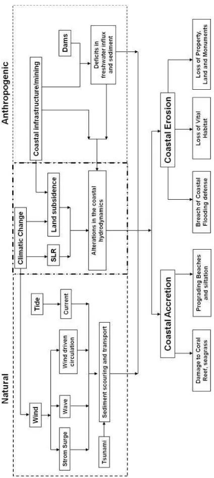
Issues related to coastal erosions can be viewed in two different aspects; one where the erosion rates are low but the threat of coastal erosion is for a longer time scale, while the second one is rather an ephemeral process, mostly concurrent with sporadic events and usually the loss is regenerated with the withdrawal of the event. The permanent loss of land, even though a slow process, pose a significant threat to valuable land, property and natural coastal resources including vital habitats. Anthropogenic pressures along the coastal region have significant contribution towards the incessant coastal erosion. Inevitable development activities along the coast and in the catchment areas of the river have induced changes in the equilibrium of the sediment transport which cause undesirable accretions and erosions along the coast. The rise in sea level and local coastal subsidence also leads to changes in the coastal processes (Nicholls and Cazenave2010). Coastal erosion during storm surge, tsunami or even monsoonal high wave period usually evolves into disaster but the impact on coastal erosion will be for a shorter period (NRC, 1990, Eurosion, 2004). A schematic diagram involving the coastal erosion processes is shown in Figure 1.
The coastal erosion, as in other maritime countries, is a serious problem along the Indian coast. India, as it forms a peninsula, is having a long coast on its east and west regions with varied coastal processes dominating the coastal dynamics. The varied coastal processes includes tide dominated regions along the northern parts of west coast, open coast with high wave energy along the southern parts of west coast, strong longshore sediment transport along the southern parts of east coast and coast strongly influenced with the river discharges along the
northern parts of the east coast. The coastal geomorphology and the land use pattern along the Indian coast also show a varied range, which includes coral reefs, mangrove belts, tidal mudflats, rocky coasts, wide sandy beaches and deltaic and bay environments.
Indian coast is relentlessly modified by the mounting development activities along the coastal region, which under improper management at times leads to severe coastal erosion. To achieve sustainable development along the coastal region and for planning measures to be taken up for protecting the coast at national level, a thorough management plan with proper understanding of the coastal processes and coastal dynamics is a crucial requirement. Inventory related to coastal erosions are the pre-requisite in understanding the coastal dynamics of the region. Even though, there are studies and inventory of coastal erosion and littoral sediment transport along the Indian coast, they are region specific (Mujabar et. al. 2011; Avinash et. al. 2010; Kudale, 2010; Pandian et. al. 2004; Malini and Rao 2004; Sanil et al. 2003; Chandramohan et al., 1993) and are inadequate for the planning level requirements at national level.
Figure 1: A schematic diagram representing the coastal erosion processes (modified after Eurosion, 2004)
environment. The present paper discusses on the salient observations and results obtained from the shoreline change mapping carried out for the entire Indian coast.
2. DATA AND METHODOLOGY
Coastal landuse/landcover maps have been prepared for entire Indian coast on 1:25, 000 scale using using IRS-P6 LISS-IV data of 2004-06 period (SAC, 2012) and SPOT-1 & 2 Multispectral and IRS-1A & IRS-1B LISS-II data of 1989-91 period and put as part of geospatial database created for Coastal Zone Information System (CZIS) developed at Space Applications Centre (SAC), Ahmedabad. These maps also depict High Tide Line (HTL) and Low Tide Line (LTL). Shoreline change mapping for the purpose of demarcating
coastal erosion, accretion and stable nature of the coast has considered changes in HTL as these changes exclude seasonal changes, whereas HTL represents Highest High Tide Line. HTL has been demarcated as Highest High Tide Line (HTL) using satellite data based on various geomorphologic/landuse features and tonal contrasts like land-ward berm/dune crest, rocks, headlands, cliffs, seawalls or embankment, permanent vegetation line, landward side of mangroves, salt pans, supra-tidal mud flats etc (Nayak et. al.1991; Boak and Turner 2005). The sensor parameters for the satellite data used is given in Table 1.
Table-1: Salient Characteristics of Satellite Data used
Satellite Sensor Bands
In addition, Landsat TM, ETM and Resourcesat-1 AWiFS data of corresponding time frames were used for rechecking and confirming the continuity of HTL in adjoining map sheets. Existing National Spatial framework has been used for seamless mosaicing and organizing the database, where one degree consists of 8X8 rectangular grid or cell and each grid represents7.5’ x 7.5’ area on 1:25, 000 scale.
Shoreline change analysis has been carried out based on spatial displacement of HTL 2004-06, with respect to the HTL of 1989-91. The spatial displacement analysis has been carried out only along the main shoreline which excludes mouths of rivers, streams, creeks and their inner parts. Area under accretion and erosion and length of shoreline getting eroded, accreted and stable were calculated for each 7.5’ x 7.5’ grid. Field checks were carried out along the entire Indian coast and based on field observations, corrections were incorporated while finalizing the maps. Classification as well as planimetric accuracy of the maps was assessed while carrying out the field work. Overall the classification accuracy of these maps range from 90-95% at 90% confidence level. The Planimetric Accuracy of these maps is 6.25 m.
been used to prepare A-3 size“Shoreline Change Atlas of the Indian Coast”, brought out as Six Volumes for the entire Indian coast (SAC, 2014).
3. RESULTS AND DISCUSSIONS
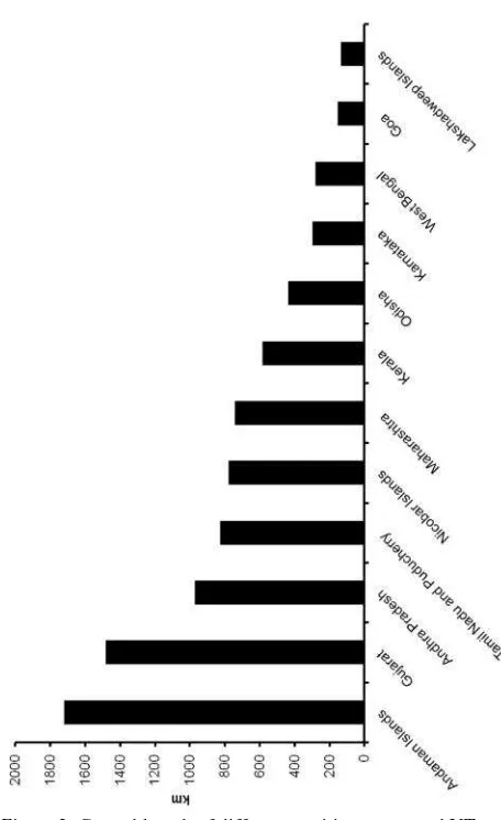
As per the inventory, the total length of the main shoreline, which excludes the length of mouths of estuary, rivers, creeks and the inner part comes out to be 8414 km. Figure 2 shows the state/UT wise distribution of coastal length.
Figure 2: Coastal length of different maritime states and UT.
Andaman Islands is having the longest coastal length ~ 1722 km and Lakshadweep Island is having the smallest coastal length of about ~ 136 km. Out of the 8414 km length of the Indian shoreline, around 45.5% (3829km) of the coastal length is observed to be under erosion (Figure 3).
Figure 3: Length of shoreline under erosion, accretion and stable along the entire Indian coast
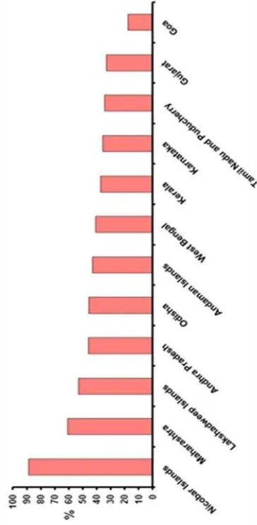
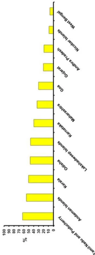
Accretion has occurred along 35.7% (3004 km) of the shoreline while 18.8% (1581 km) of the shoreline is observed to be more or less stable. The state wise distribution of shoreline length under erosion, accretion and stable is given in Table 2 and Figure 4.
Table-2: Coastal length under erosion, accretion and as stable in different Maritime States/Union Territories of India (Excludes mouths of rivers/streams/creeks and their inner parts)
Maritime States and Union Territories* (UT)
Erosion Length
(km)
Accretion Length
(km)
Stable Length (km)
Total Length
(km)
Gujarat, Daman* & Diu*
486.43 297.99 697.71 1482.1
Maharashtra 449.5 244.47 48.29 742.26
Goa 27.03 46.98 81.38 155.39
Karnataka 106.12 118.65 73.31 298.08
Kerala 218 294 73.6 585.6
Tamil Nadu and Puducherry*
281.56 514.11 29.25 824.92
Andhra Pradesh 443.88 186.94 340.45 971.27
Odisha 199 205 32.1 436.1
West Bengal 115.06 19.46 147.68 282.2 Lakshadweep
Islands * 72.03 63.24 1.01 136.28
Andaman
Islands* 740.37 944.84 36.83 1722
Nicobar
Islands* 690.1 68.3 19.23 777.63
Total 3829.1 3004 1580.8 8413.9
The length of shoreline under erosion is longest for Andaman Islands (740.34 km) and it is shortest for the state of Goa (27.03 km), while the shoreline length that has accreted is also maximum for the Andaman Island (944.84 km) and is minimum for the state of West Bengal (19.46 km).
Figure 4: Coastal length under erosion, accretion and as stable in different Maritime States/Union Territories (Excludes mouths of rivers/streams/creeks and their inner parts)
Among various maritime states and Union Territories, Tamilnadu has the highest net increase of its coastal area which is of about 25.45 sq km (Table 3), while net loss of coastal area is maximum for the Nicobar Islands, which is around 94 sq km.
Table 3: Coastal area under erosion and accretion in different Maritime States/Union Territories of Indian coast
Maritime States and Union Territories*
Area under accretion
(sq. km)
Area under erosion (sq.km)
Net gain/loss (sq. km) Gujarat, Daman*
& Diu* 43.45 27.28 16.17
Maharashtra 5.08 7.83 -2.75
Goa 1.53 0.771 0.759
Karnataka 6.26 5.16 1.1
Kerala 9.54 5.31 4.23
Tamil Nadu and
Puducherry* 42.64 17.19 25.45
Andhra Pradesh 25.14 46.89 -21.75
Odisha 13.3 13.8 -0.5
West Bengal 1.52 11.63 -10.11
Lakshadweep
Islands* 0.83 1.7 -0.87
Andaman Islands* 27.09 17.93 9.16
Nicobar Islands* 0.77 94.72 -93.95
Total 177.15 250.211 -73.061
Maharashtra, Andhra Pradesh, Odisha, West Bengal, Lakshadweep and Nicobar Islands have a net loss of area, while the other maritime states and Union Territory have a net gain along its coastal region. The analysis also shows that the Indian coast has lost a net area of about 73 sq km during 1989-91 and 2004-06 time frame.
Figure 6: Coastal length under accretion in different Maritime States/Union Territories
The results from the shoreline displacement analysis are a major contribution towards the proper understanding of shoreline dynamics along the Indian coastal region. As India has a long shoreline with a varied range of coastal processes and coastal geomorphology, the shoreline displacement also shows a varied response along the different segments of the coast.
The rocky coastal stretches along the Saurashtra and central western coast show more or less stable shoreline, where local shoreline dynamics are observed along pocket beaches within these stretches. The destruction and loss of land due to sea erosion is a severe problem, particularly for a country like India facing explosive population growth. Coastline is a dynamic morphological entity, which responds to the external forces exerted by waves, tides, nearshore currents and the resultant sediment transport. When the resultant sediment transport entering a particular area is greater than the sediment going out
from the area, accretion or beach development takes place. On the other hand, when there is a deficit of the incoming sediment supply into a particular area with reference to the sediment going out of the same area, beach erosion takes place. Beaches act as constant absorbers of the wave energy of water and though subject to small disturbances, remain in equilibrium. However, sometimes this equilibrium gets disturbed due to either natural phenomena or human intervention. When shore structures are constructed, it is quite likely that equilibrium condition is destroyed. Since this can cause considerable damage and reduce the effectiveness of such structures, it is necessary to study the equilibrium condition of shores before constructing such structures. Therefore, it is of utmost importance to get information on accreting, eroding and stable coasts so that effective measures to combat sea erosion may be taken.
Figure 7: Stable Coastal length in different Maritime States/Union Territories
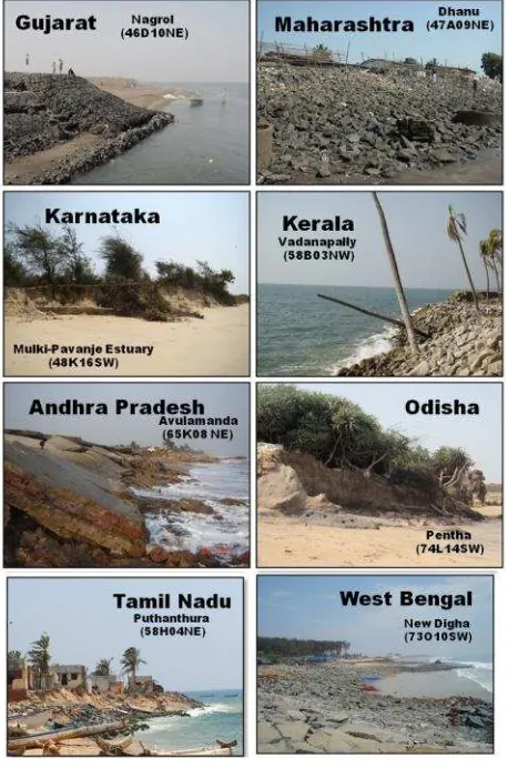
Figure 8 shows representative field photographs of severe erosion along different maritime states of India. Human activities that remove or degrade protective landforms – removing beach sands, weakening coral reefs, bulldozing dunes or destroying mangrove swamps, diminish the degree of natural protection. Human interference with natural coastal processes such as the building of groins, jetties, breakwaters, sea walls, artificial dunes, and other structures is occasionally successful, but in some cases it has caused considerable coastal erosion. These have had mixed success, and often cause additional problems in adjacent areas.
Figure 8: Representative field photographs of severe erosion along different maritime states of India
Figure 9 shows LISS IV images of 2011-12 covering certain hotspots along the Indian coast overlaid with the HTL of 1989-91 and 2004-06, except for Figure 9(a), where LISS III image of 2006 has been shown. The figure elucidates the different aspects of coastal issues along the Indian coast. The major natural processes involved in the shoreline dynamics is wave induced erosion (Kosamba, Gujarat; Figure 9a) and the littoral drift. The alterations of coastal geomorphic features by the littoral drifts are evident from the dynamics of Chilika inlet mouth, Odisha (Figure 9b) and chocking of river/inlet mouths (Kalavali creek mouth, Maharashtra; Figure 9c).
The processes of longshore sediment transport, occurring naturally along the coasts are highly altered by the
constructions of breakwaters and have triggered coastal erosions due to obstruction of the littoral drift (Kudale2010).
Figure 9: IRS LISS-IV images of 2011-12/2006 overlaid with HTL of 1989-91 and 2004-06 (a) Kosamba, Gujarat (LISS-III, 2006) (b) Chilika, Odisha, (c) Kalavali creek, Maharashtra (d) Gopalpur, Odisha, (e) Panmana, Kerala and (f) Mumbai, Maharashtra, (g) Palletummalapalem, Andhra Pradesh, (h) Pentha, Odisha, (i) Katchall Island, Nicobar Islands
Figure 9d is an example of obstruction of littoral drift at the Gopalpur Port, Odisha inducing coastal erosion towards its north. Sand mining (Panmana, Kerala; Figure 9e) and land reclamations (Mumbai, Maharashtra; Figure 9f) along the coast of India are also crucial anthropogenic activities altering the sediment dynamics and triggering coastal erosions. Coastal erosions induced by the changes in equilibrium of sediment transport along the coast resulted by the dam constructions in the catchment areas of rivers (Malini and Rao, 2004) are evident along Palletummalapalem, Andhra Pradesh (Figure 9g). Significant erosions are observed along the coastal stretch of Pentha, Odisha (Figure 9h), possibly due to land subsidence, which requires imperative study. Natural disaster like December-2004, Indian Ocean tsunami have imparted permanent loss of its vital habitat and coastal features along the Katchall Island in Nicobar (Figure 9i).
4. CONCLUSIONS
Goa has highest percentage of stable shoreline (52.4%). The cause of severe erosion along Andaman coast and high accretion along Tamilnadu coast is probably due to Indian Ocean tsunami of December, 2004. At many other parts of the Indian coast coastal erosion is occurring due to construction of dams in catchment areas of rivers, developmental activities such as construction of Ports/Fishing Harbours/Jetties and at parts due to land subsidence/sea level rise. The analysis shows that the Indian coast has lost a net area of about 73 sq km during 1989-91 and 2004-06 time frame. In Tamilnadu, a net area of about 25.45 sq km have increased due to accretion, while along Nicobar Island about 93.95 sq km is lost due to erosion. The inventory along with current status of coastal protection measures taken up by concerned State Departments has been used to prepare “Shoreline Change Atlas of the Indian Coast”, brought out as Six Volumes for the entire Indian coast. This baseline data is aimed towards initiating appropriate action for protecting the Indian coast by concerned maritime States and Union Territories besides use by the scientific community as well decision makers of the country.
Further work has been taken up by interpreting the shoreline using latest LISS-IV images and work has been completed for the Gujarat and Odisha states, whereas work is near completion for Andhra Pradesh and Tamilnadu coasts.
ACKNOWLEDGEMENTS
We would like to place on record our deep sense of gratitude to Dr. R.R. Navalgund, former Director, Space Applications Centre, Ahmedabad and Shri A.S. Kiran Kumar, Director, Space Applications Centre, Ahmedabad for their keen interest, guidance and constant encouragement during the entire course of this project. We are grateful to Dr. Shailesh Nayak, Secretary, Ministry of Earth Sciences (MoES), Government of India, New Delhi for initiating this project when he was at Space Applications Centre, Ahmedabad and providing guidance and encouragement. We would like to place on record our appreciation for the guidance and support provided by Dr. J.S. Parihar, former Deputy Director, EPSA, Dr. P.K. Pal, Deputy Director, EPSA and Dr. Manab Chakraborty, Group Director, GSAG, Space Applications Centre, Ahmedabad.
We gratefully acknowledge the funding support provided by Ministry of Water Resources and Ministry of Environment, Forests and Climate Change, Government of India. Our special thanks are due to Chairman and Members of Coastal Protection and Development Advisory Committee (CPDAC) for necessary support.
We are thankful to Dr. K.S. Jayappa, Department of Marine Geology, Mangalore University, Mangalore, Prof. K. Nageswara Rao, Department of Geo-Engineering, Andhra University, Vishakhapatnam, Prof. C.J. Kumanan Centre for Remote Sensing, Bharathidasan University, Tiruchirapalli, Dr. Ajit Pattnaik, Chief Executive, Chilika Development Authority, Bhubaneswar and Dr. Somenath Bhattacharyya, former Director, Institute of Environmental Studies and Wetland Management, Kolkata for providing logistic support along with their colleagues during the field work along parts of the Indian coast.
REFERENCES
Avinash, K., Narayana, A. C., and Jayappa, K. S., 2010. Shoreline changes and morphology of spits along southern
Karnataka, west coast of India: A remote sensing and statistics-based approach. Geomorphology, 120(3–4), pp. 133–152.
Boak, E. H., and Turner, I. L., 2005. Shoreline definition and detection: A review. Journal of Coastal Research, 2(4), pp. 688-703.
Chandramohan, P., Sanil, K. V., and Nayak, B. U., 1993. Coastal processes along the shorefront of Chilika Lake east coast of India. Indian Journal of Marine Sciences, 22, pp. 268-272.
Eurosion. 2004. Living with coastal erosion in Europe: Sediment and space for sustainability. Part IV — a guide to coastal erosion management practices in Europe: lessons learned. 27.
Kudale, M. D., 2010. Impact of port development on the coastline and the need for protection. Indian Journal of Geo-Marine Sciences, 39(4), pp. 597-604.
Malini, H. B., and Rao, K. N., 2004. Coastal erosion and habitat loss along the Godavari delta front – a fallout of dam construction (?). Current Science, 87(9), pp. 1232-1236
Mujabar S., Chanrasekar N., and Magesh, N. S., 2013. Shoreline change analysis along the coast between Kanyakumari and Tuticorin of India using remote sensing and GIS. Arabian Journal of Geosciences, 6(3), pp. 647-664.
Nayak, S. R., Bahuguna, A., Shaikh, M., Rao, R. S., Trivedi, C. R., Prasad, K. N., Kadri, S. A., Vaidya, P. H., Patel, V. B., Oza, S. H., Patel, S. S., Rao, T. A., Shereiff, A. N., and Suresh, P. V., 1991. Manual for mapping of coastal wetlands/landforms and shoreline changes using satellite data. Technical Note, IRS-UP/SAC/MCE/TN/32/91, Space Applications Centre, Ahmedabad.
Nicholls, R. J., and Cazenave, A., 2010. Sea-Level Rise and Its Impact on Coastal Zones. Science, 328, pp. 1517.
NRC, 1990. Managing coastal erosion. Committee on Coastal Erosion Zone Management, Water Science and Technology Board, Marine Board, Commission on Engineering and Technical System, National Research Council. Washington, DC, National Academy Press. 182.
Pandian, P. K., Ramesh, S., Murthy, M. V. R., Ramachandran, S., and Thayumanavan, S., 2004. Shoreline Changes and Near Shore Processes along Ennore Coast, East Coast of South India. Journal of Coastal Research, 20(3), pp. 828–845.
SAC, 2012. Coastal Zone of India, Space Applications Centre (ISRO), 2012, 601 p. ISBN: 978-81-909978-9-8.
SAC, 2014, Shoreline Change Atlas of the Indian Coast, (Volume 1 Gujarat, Daman and Diu, Volume 2 Maharashtra & Goa, Volume 3 Karnataka & Kerala, Volume 4 Tamilnadu, Puducherry & Andhra Pradesh, Volume 5 Odisha & West Bengal, Volume 6 Lakshadweep & Andaman & Nicobar islands), SAC/EPSA/GSAG/GSD/A/01/14, May, 2014.