Learning to Think Spatially
GIS as a Support System in the K-12 Curriculum
D
o you know what packing the trunk of a car, assembling a child’s toy, and using MapQuest for driving directions all have in common? These common activities are solved using spatial thinking. Spatial thinking is a skill used in everyday life, the workplace, and science to solve problems using concepts of space, visualization, and reasoning. By visualizing relationships of spatial structures in terms of locations, distances, directions, shapes, and patterns, we can understand and analyze the properties of objects and relationships between objects.Spatial thinking can be taught to all students using appropriately designed tools, technologies, and curricula. These tools come in many forms—from simple, low-tech items such as pencil and paper to complex, high-tech resources such as geographic information systems (GIS). Despite its underlying role in the National Standards for Science and for Mathematics, spatial thinking is currently not explicitly incorporated into the K-12 curriculum.
Learning to Think Spatially: GIS as a Support System in the K-12 Curriculum explains the importance of spatial thinking and examines how it can be infused into existing standards-based instruction across the K-12 curriculum through the development of appropriate tools. Spatial thinking must be recognized as a fundamental part of K-12 education, as it is a key ingredient for problem solving.
The United States needs a national initiative to integrate spatial thinking across the K-12 curriculum in courses such as mathematics, history, and science; such an initiative would not require developing a new, separate course focusing solely on spatial thinking. Ultimately, this initiative will result in a generation of students who engage in spatial thinking to achieve success throughout their lives as citizens and members of the 21st century workforce.
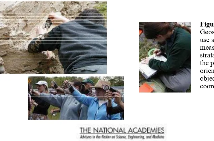
Figure 1
Spatial Thinking in the Classroom
Although everyone thinks spatially, people do so in different ways and with varying degrees of conidence and success depending on the situation. Some people are good at spatial reasoning, while others struggle. The necessary skills can be taught to students using a number of appropriately-designed tools, technologies, and curricula. Advances in computer hardware and software are enabling spatial thinking to be more easily accessible to a wider student-base. There are a number of examples showing how teachers are creatively adding spatial thinking into their lesson plans (Box 1 and 2).
Currently, there are no national or state standards for spatial thinking. Without such guidelines, spatial thinking will not be recognized and supported throughout the nation’s classrooms. Because spatial thinking is not a stand-alone discipline in the way that other subjects are, standards for spatial thinking should be developed and consist of general guidelines for what students need to know about spatial
thinking concepts so that they can learn to apply new approaches when solving challenging problems in a range of subject areas. These new standards should link spatial thinking to existing disciplinary standards, and the guidelines should be integrated into as
many subject areas and grades as possible. The new
Box 1: Students Use GIS to Analyze a Local Problem:
The Characteristics and Potential Problems in a School’s Tree Population
Changes in Rhode Island’s state planning guidelines in the late 1990s required every Rhode Island town to include an urban forestry component in its comprehensive management plan, but few communities were prepared to do so. Students from ten Rhode Island communities used GIS programs, ArcView and CITYgreen, to map and analyze trees at their schools to help their own communities meet the state mandate. They learned about the urban ecosystem, trees, and the power of spatial analysis in addressing community issues. American
Forests, a nonproit citizen conservation organization, developed CITYgreen.
For example, students at one school prepared the irst map below showing trees conlicting with utility lines by digitizing the school building and trees on an orthophotograph of the school’s property. Trees in conlict
with utility lines were assigned a different color from other trees to create a thematic map. They also queried
the data to select all trees that were in poor or dying condition and that conlicted with utility lines or the school
building. They converted the selected trees to a new category called “Hazardous Trees” and changed their symbol color to purple in the second map below.
The students presented their observations and recommendations both in class and to the local town council. With a new database of tree information and a list of recommendations, the local public works department came a step closer to developing a program of tree maintenance and replanting in the town. SOURCE: English and Feaster, 2003, pp.179–199.
Trees Conlicting with Utility Lines Hazardous Trees: Trees in poor or dying condition
standards will lead to the development of innovative teaching methods and programs to train teachers and new ways to assess levels of spatial thinking and the performance of educational tools.
GIS: An Important Spatial Thinking Tool
GIS is one type of tool that can be used in teaching and supporting spatial thinking across a range of subjects in the K–12 curriculum. It is an integrated system of hardware and software designed to manage, manipulate, analyze, model, and display spatial data. GIS allows users to ask questions about data and perform operations in spatial databases. GIS is used in the real world to solve important problems such as identifying where to build new roads, determining how many people will be affected by a lood or a ire, and identifying changes in land use (See Box 1 for an in-depth example of how GIS has been applied in the classroom to solve real world problems). Therefore, it is an important tool for students to learn because it can help prepare them for a number of careers in science and technology, for example being a city planner, architect, emergency management oficial, or air trafic controller. It can also accommodate different types of learners at varying educational levels and can be adapted for a range of settings.
A variety of GIS-based curriculum materials, courses, and data sets are available that offer support to middle and high school teachers incorporating GIS into their lesson plans. These materials are available in part because experts develop and test learning modules in classrooms and through peer-to-peer exchange in which teachers develop, test, and share materials among themselves. Access Excellence (http://www.accessexcellence.org) and the Digital Library for Earth System Education (DLESE; http://www.dlese.org) are two resources for sharing materials. DLESE has over 3,000 items indexed and described in terms of age applicability and subject, and most of the items are designed for K–12 education. Additionally, ESRI’s Geography Network site (www.geographynetwork.com) contains a number of resources, such as datasets.
While GIS can make a signiicant impact on teaching and learning about spatial thinking, it must be incorporated into a standards-based curriculum and used alongside other types of tools in the classroom.
Box 2: Thinking Inside the Box
As an example of a very effective and imaginative low-tech system for supporting spatial thinking, a class of nine-year-old children were presented with a box. The contents were unknown to them; their challenge was to ind out what was inside the box through an adaptation of spatial sampling. The top of the box was perfo-rated with 100 holes, arranged in a 10 × 10 grid. The two axes were labeled from 1–10 and from A–J, thus ensuring that each hole could be given a unique spatial identiier. Next to the box was a sheet of paper, also laid out with an identical 10 × 10 grid with the same axis identiiers. The chil -dren were given knitting needles and irst had to calibrate them to provide “depth” readings below the surface of the box when the needle was in-serted into a hole and it touched whatever object was in the box. They created summary tables of their data (in effect x-y-z coordinates), and then transferred the coordinate data onto the paper using lego blocks for the z coordinate. When they inished creating a lego shape and surface, they were allowed to open the box. Inside was a three-dimensional model of a mountain range which they had, much to their excitement, recreated through a classic example of spatial thinking.
Preparing Students for the Future
Additional Resources:
Major GIS Software Products Used in K–12 Education
Programs
World Wide Web Address
ArcExplorer* http://www.esri.com/arcexplorer
ArcView
http://www.esri.com/software/arcview
ArcVoyager* http://www.esri.com/industries/K–12/voyager.html
Atlas GIS
http://rpmconsulting.com/
Autodesk Map http://usa.autodesk.com/adsk/servlet/index?siteID=123112&id=3081357
GeoMedia
http://imgs.intergraph.com/geomedia/default.asp
GRASS
http://openosx.com/grass/
Idrisi
http://www.clarklabs.org
Mac GIS
http://dslmac.uoregon.edu/macGISinfo.html
MapInfo
http://www.mapinfo.com
Maptitude
http://www.caliper.com/
Mfworks
http://www.keigansystems.com/Products/Mfworks/Mfworks3.html
My World*
http://www.worldwatcher.northwestern.edu/MyWorld
*Software programs customized for K–12
Committee on Support for Thinking Spatially: Roger M. Downs (Chair), The Pennsylvania State University; Sarah W. Bednarz, Texas A & M University; Robert A. Bjork, University of California, Los Angeles; Peter B. Dow, First Hand Learning, Inc.; Kenneth E. Foote, University of Colorado, Boulder; J. Freeman Gilbert, University of California, San Diego; Reginald G. Golledge, University of California, Santa Barbara; Kim A. Kastens, Lamont-Doherty Earth Observatory of Columbia University; Gaea Leinhardt, University of Pittsburgh; Lynn S. Liben, The Pennsylvania State University; Marcia C. Linn, University of California, Berkeley; John J. Rieser, Vanderbilt University; Gerald M. Stokes, University of Maryland and Paciic Northwest National Laboratory; Barbara Tversky, Stanford University; Anthony de Souza (Study Director), National Research Council.
This report brief was prepared by the National Research Council’s Board on Earth Sciences and Resources of the Division of Earth and Life Studies based on the committee’s report. For more information, contact the Board on Earth Sciences and Resources at (202) 334-2744. Learning to Think Spatially: Geographic Information Systems (GIS) as a Support System in the K-12 Curriculum is available from the National Academies Press, 500 Fifth Street, NW, Washington, D.C. 20001; (800) 624-6242; www. nap.edu.
Permission granted to reproduce this brief in its entirety with no additions or alterations.