SUSTAINABLE FISHERIES
MANAGEMENT PROJECT (SFMP)
Vulnerability assessment for Axim
Fish Landing Site, Nzema East
District
This publication is available electronically on the Coastal Resources Center’s website at http://www.crc.uri.edu/projects_page/ghanasfmp/
For more information on the Ghana Sustainable Fisheries Management Project, contact:
USAID/Ghana Sustainable Fisheries Management Project Coastal Resources Center
Graduate School of Oceanography University of Rhode Island
220 South Ferry Rd.
Narragansett, RI 02882 USA
Tel: 401-874-6224 Fax: 401-874-6920 Email: [email protected]
Citation: Adams, O., Kankam, S., Owusu Donkor, P. (2016). Vulnerability Assessment for Axim Fish Landing Site, Nzema East District. The USAID/Ghana
Sustainable Fisheries Management Project (SFMP). Narragansett, RI: Coastal Resources Center, Graduate School of Oceanography, University of Rhode Island and Spatial Solutions, Accra, Ghana. GH2014_ACT047_SpS. 21 pp. Authority/Disclaimer:
Prepared for USAID/Ghana under Cooperative Agreement (AID-641-A-15-00001) awarded on October 22, 2014 to the University of Rhode Island and entitled; the USAID/Ghana Sustainable Fisheries Management Project (SFMP).
This document is made possible by the support of the American People through the United States Agency for International Development (USAID). The views and opinions contained in this report are those of the SFMP team and are not intended as statements of policy of either USAID or the cooperating organizations. As such, the contents of this report are the sole responsibility of the SFMP Project team and do not necessarily reflect the views of USAID or the United States Government.
Detailed Partner Contact Information:
USAID/Ghana Sustainable Fisheries Management Project (SFMP) 10 Obodai St., Mempeasem, East Legon, Accra, Ghana
Telephone: +233 0302 542497 Fax: +233 0302 542498
Maurice Knight Chief of Party [email protected]
Kofi Agbogah Senior Fisheries Advisor [email protected] Nii Odenkey Abbey Communications Officer [email protected]
Bakari Nyari Monitoring and Evaluation Specialist [email protected] Brian Crawford Project Manager, CRC [email protected]
Justice Odoi USAID Administrative Officer Representative [email protected] Kofi.Agbogah #3 Third Nautical Close,
Nungua, Accra, Ghana
[email protected] Daasgift Quality Foundation
Headmaster residence, Sekondi College Sekondi, Western Region, Ghana 233 243 326 178
For additional information on partner activities:
CRC/URI: http://www.crc.uri.edu
CEWEFIA: http://cewefia.weebly.com/
DAA: http://womenthrive.org/development-action-association-daa Daasgift:
https://www.facebook.com/pages/Daasgift-Quality-Foundation-FNGO/135372649846101 Friends of the Nation: http://www.fonghana.org Hen Mpoano: http://www.henmpoano.org
SNV: http://www.snvworld.org/en/countries/ghana SSG Advisors: http://ssg-advisors.com/
ACRONYMS
DEM Digital Elevation Model
DSAS Digital Shoreline Assessment Software
FAO Food And Agriculture Organization Of The United Nations GPS Global Positioning Systems
SDF Spatial Development Framework
TABLE OF CONTENTS
Demography and Population Dynamics ... 3
Existing Spatial Plans for Axim ... 4
VULNERABILITY ASSESSMENT ... 5
Methods... 5
Study Setting ... 5
Sources of Data and Analytical Tools ... 5
RESULTS ... 6
Assets at Risk ... 6
Sea inundation and shoreline erosion ... 6
Vulnerability of Economic Assets ... 11
Vulnerability of fish processing households ... 14
REFERENCES ... 16
LIST OF FIGURES
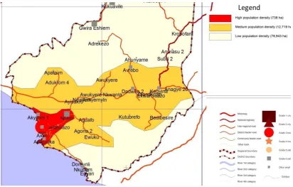
Figure 1 Axim in the context of the Western region and Nzema East Municipality ... 2Figure 2 Population Densities in Major Communities in Nzema East District ... 3
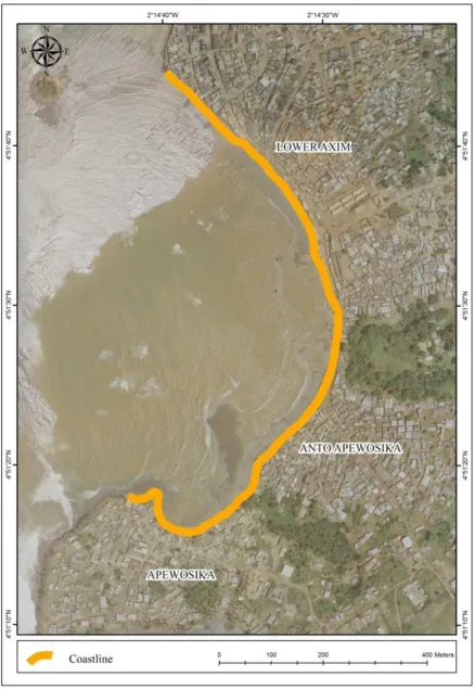
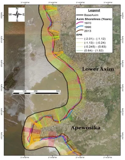
Figure 3 Map of study area indicating coastline stretch of Axim ... 7
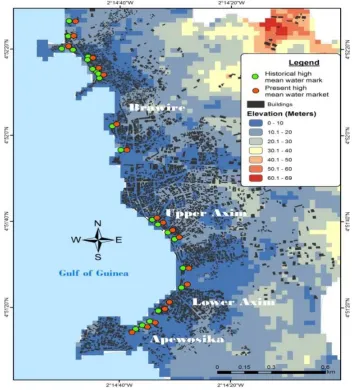
Figure 4 Historical and present mean high water mark in Axim ... 8
Figure 5 Frequency of sea level rise / flooding of houses in Axim ... 9
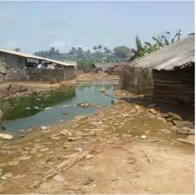
Figure 6 Choked lagoon in Brawire, Axim ... 9
Figure 7 Shoreline erosion in Axim ... 10
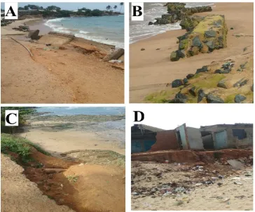
Figure 8 Damage to Axim infrastructure ... 11
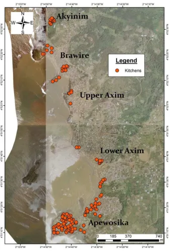
Figure 9 Distribution of fish processing facilities in Axim ... 12
Figure 10 Types of ovens ... 13
Figure 11 Distance of processing sheds from sea and high water mark in Axim ... 14
Figure 12 Vulnerability of fish processing households to climate change ... 15
INTRODUCTION
The USAID Ghana / Sustainable Fisheries Management Project (SFMP) provides capacity building support for coastal distict planners to foster improved planning for resilent coasts as well as protection of water dependent uses of the coast including for fish landing. To this end, this report highlights the case of Axim which is one among many prominent fish landing sites in Ghana, yet is faced with hazards and evolving impacts of coastal climate change. The report complements similar assessments carried out in Axim to assess and understand coastal hazards and provide tools for district and regional planners to better coordinate actions to build community resilience.
This assessment focuses on investigating the vulnerability of fish processing infrastructure in Axim to the impacts of flooding and evolving sea level rise as a result of climate change. In addition, economic impacts of flooding and evolving sea level rise on fishing households and infrastructure are also assessed. The assessment takes into account the overall planning context in the Nzema East Municipal Assembly and how this influences decisions and choices for building coastal resilience.
BACKGROUND
The Western Region is known for its abundance of resources that includes coastal resources. Axim, the third biggest commercial center in the Western Region after Sekondi-Takoradi and Tarkwa in terms of population growth and economic activities became one of the historical commercial centers in Ghana partly because of its contribution towards the fishing industry. The commercial importance of Axim and its flourishing fishing industry led to an intense population growth mostly due to in-migration by fisher folk, most of which attained permanent resident status over the years in Axim.
The effect of this in-migration over the years has led to high population growth, particularly in the coastal communities. The burgeoning coastal population in Axim is not only a source of anthropogenic pressure on fragile coastal resources, but also an issue of concern as climate change impacts such as flooding and sea level rise continue to undermine public safety and key livelihood assets. With no other option, the coastal population typically occupies the most marginal land areas that increase their exposure and sensitivity to hazards and climate change impacts.
Sea level rise and erosion are the hazard events experienced in Axim. They are not new coastal phenomena in this community as it has persisted since the colonial times. The
PLANNING CONTEXT
Location and geophysical characteristics
Axim is the Capital of the Nzema East Municipality, an area encompassing 2,194 square kilometers (9.8 percent of the total area of the Western Region). Axim lies within the southwestern equatorial climatic region. As a result, it enjoys two major rainfall seasons, betweenApril to July, and September to November. Mean rainfall for the year ranges
between 1500 mm and 2000 mm (Tanu, 2008). The area enjoys a mean temperature of about 26.30 c with relative humidity usually 75% - 85% high. This accounts for the high and frequent shower of rainfall within the area. Axim is on a minor coastal basin underlaid by metamorphosed lava weathered ferralsols. Patches of grass and shrubs are the common vegetation cover in the community with few mangrove forests confined to the edges of few lagoons which have been under stress due to cutting and residential growth.
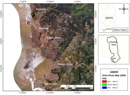
Physically, the coast of Axim is characterized by several bays and headlands with dotted rocky islands (Figure1). Serious erosion within the bays, led to the construction of sea defence walls within surburbs such as Upper Axim and parts of Brawire community in the 1960s. This slowed erosion initially; however, over time the defence systems began fail giving way to severe erosion along the shores of Axim.
Figure 1 Axim in the context of the Western region and Nzema East Municipality
shrubs are the common vegetation cover in Axim. Mangrove forests are limited but confined to river estuaries that are diminishing at a faster rate both from sea impact and anthropogenic influences. Mangrove vegetation has a protective capacity to sea wave advances but their fragmentation and near destruction has increased vulnerability of the shoreline and inhabitants in Axim.
Demography and Population Dynamics
The population of greater Axim, including nearby villages is approximately 30,000 as of 2010 census. There is a modest hospital in town. The economy is based on fishing, subsistence farming and government services. The population density of 68 for the
Municipality after the 2010 census may indicate no great pressure of population on the Land. However the same cannot be said of the pressure on resources or what the land can generate particularly in Axim. Settlements or growth points like Axim, Nsein, Bamiankor and
Kutukrum have been experiencing relatively higher population densities with corresponding pressure being exerted on the existing limited infrastructure and other resources. From the total municipal population of 52,672, a total of 29,829 constituting 56.9% live in Axim. This reinforces the overwhelming socio-economic influence of the town on the entire
municipality.
The growth rate of Axim was 3.2 as against a regional average of 2.7 per cent per year in 2010. This probably is due to in-migration from the smaller settlement to Axim for economic opportunities, the predominant one being fishing. The population density of Axim as shown in Figure 2 is relatively high compared to other settlements. The direct impact of the surge in population is land availability to conduct economic activities and the provision of related infrastructure.
Existing Spatial Plans for Axim
The western region and its districts have been the beneficiary of a series of spatial development framework. Axim being an important municipality within the region has benefited from these SDFs. The Western Regional Spatial Development Framework
(WRSDF) gave credence to the importance of Axim and made proposals for the municipality as one of the major fishing centers and also a major economic hub. This goes to emphasis the need for land to enable economic activities to be carried out in an effective manner.
The next set of spatial plans for the Nzema Municipal Assembly is the Municipal Spatial Development Framework prepared in 2012. The municipal SDF makes provision for the preservation of wet lands including the coast and all water bodies as conservation areas. In this regard the Axim coastal area including other nearby fishing communities are included in the conservation area.
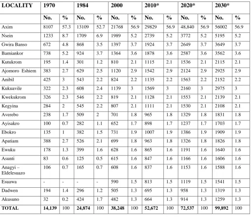
In general these SDFs recognize the importance of fishing as a major economic activity in Axim and the need to protect this uses of the coast. Fishing has over the years shaped the economic future of the town and the entire municipality. Population projection from both SDFs predicts a study progression in population growth as shown in Table 1 below.
Table 1: Population estimates and projected population in Nzema East Municipality
VULNERABILITY ASSESSMENT
Methods
Study Setting
Axim lies within the south-western equatorial climatic region. As a result, it enjoys two major rainfall patterns mostly, April to July and September to November before experiencing dry season from December through to February. Mean rainfall for the year ranges between 1500 mm and 2000 mm (Tanu, 2008). The months of June and July record the highest rainfall amounts. The area enjoys a mean temperature of about 26.30 c with relative humidity usually 75% - 85 % high. This accounts for the high and frequent shower of rainfall within the area.
Sources of Data and Analytical Tools
Methodology employed for this assessment ranges from spatial techniques, observations and field interviews. Digital elevation model covering the area was downloaded from USGS website and used for elevation map for the study. On-screen digitizing of aerial photos was employed to capture all structures within Axim. This was complemented by field GPS mapping of fish processing ovens and validation of on-screen mapped structures. The research team mapped high mean water mark based on local perception within the community at various points.
Digital shoreline assessment software (DSAS) was employed in mapping shoreline erosion and to determine the imapcts of sea wave action. Various shoreline years were captured for the analysis: 2013, 1996 and 1970. The 1970 and 1996 shorelines were extracted from topo-sheets covering the study areas. The shoreline for 2013 was digitized from Google Earth. Due to the various sources of the data employed, there could be few errors and uncertainty levels, but the magnitude of these errors are infinitesimal to affect the outcome of the study.
Shorelines from the topo-sheets had uncertainty range of +/- 4.2 while the 2013 shoreline had 9.3 uncertainty levels. Transects were cast through these shorelines to estimate the end point rate of shoreline movements in these communities.
In studying the vulnerability of fish processing households, interview schedules were employed and administered through Kobotoolbox platform. Questions ranging from oven types used, number of ovens, and cost accrued were gathered. Also, data on respondents’ experiences from the effects of floods on theirn fish processing ovens were gathered. In order to understand the effects of sea level rise, inundation, and shoreline erosion on fish
processing households, socio-economic information about such households were collected and analyzed.
RESULTS
Assets at Risk
Major assets at Axim’s coastline are at risk of flooding and erosion damage. These assets include fish landing site, coastal road and fishing settlements. These are susceptible to shoreline erosion and inundation due to increasing wave action. Severe land losses due to shoreline erosion have left little space for landing catch along the 1.5 km stretch of coastline in Axim. However, sensitivity to shoreline erosion varies for different segments of the coastline and related key assets. The areas with greatest risks are arguably, Apewosika and Anto Apewosika (Figure 3), where failed shoreline engineering works have resulted in unsafe living and fish landing conditions. According to key informants of Anto Apewosika, the Hydrological Services Department supervised the installation of gabions along certain segments of the shoreline about 10 years ago. The aim was to trap and retain sediments and create areas for fish landing and handling as well as for docking canoes. Apparently, poor engineering and siting decisions are among the main reasons for the present situation where gabions are not functioning but rather compounding risks to users of the fish landing site. The coastal road in Axim provides the most convenient vehicular access to the shore area. The road is partially protected by a sea defense wall that overflows during high tides resulting in frequent flooding of the road and neighborhoods. The poorest and marginalized
populations are those most vulnerable to flooding and erosion as their settlements are squeezed into the riskiest locations along the shoreline.
Sea inundation and shoreline erosion
Axim is exposed to different sources of floods with varying magnitude. The sea, gutters, rivers and wetlands are the main sources of flooding in the community. A view shared by respondents as 76% attributed the common source of flooding to the sea, 13% rivers, 7% wetlands/lagoons and 4% to gutters and drains. The sea doesn’t only inundate houses and properties but its wave actions have also led to erosion along the beaches of Axim. Frequent inundation of the community by sea action can be attributed to low elevation as mean high water mark is able to reach 52 meters inland. Axim has a mean elevation of 17.9 meters and the highest point around 69 meters (Figure 4). Unfortunately, 80% of fish processing
households as well as over 94% settlements are within the 10 meter elevation contour. This zone is the main economic or business hub in Axim.
Overflow of gutters is another phenomena leading to flooding in Axim. This partly explains recent climate change and its impact on local communities. The main trigger for flooding is persistent torrential rainfall for about three days. Because of the intensity of physical development and creation of impervious surfaces within the community, high intensity of rainfall results in high flow velocities greater than the carrying capacity of the gutters. The effect is an overflow into the commercial business center destroying millions of cedis worth of property. Lagoon and wetlands on the other hand have been filled with sediments (Figure 6). This has reduced the ability of these natural systems to absorb excess rain and sea water hence allowing free flow of water into houses. In Brawire, one of the suburbs of Axim, lagoons have been choked, and are serving as landing sites.
Figure 5 Frequency of sea level rise / flooding of houses in Axim More than once
a year 50%
More than once a week
22% More than twice
a day
2%
Once a day
12%
Once a week
7%
Once a year
7%
Another predominant hazard resulting from sea inundation and wave action is shoreline erosion. Analysis of erosion rates indicates the shores of Axim retreat at about 0.48 meters yearly with a net shoreline movement of 19.17meters from 1970 to 2013 (Figure 7). The relatively slow rate of erosion has resulted from partial sea defense systems installed along the shoreline. In the future, rate of erosion will likely increase with most of the sea walls now collapsed. In terms of net shoreline movement, areas in Apewosika showed a relatively faster rate of erosion of -86 meters for the same 43 year period.
Upper Axim has a much more profound rate of shoreline erosion as most of the sea defense systems originally built have collapsed (Figure 8, panel B). Others have their foundation exposed and are very weak posing risk to people. Erosion has led to the complete destruction of some houses and portions of roads in Brawire.
Panels (A) and (B) shows broken sea defense (C) part of road being destroyed by sea waves (D) buildings destroyed by sea erosion.
The rate of erosion has also been attributed to sand mining activities as beach sand is the most preferred for molding blocks for housing. This needs to be checked as climate change coupled with this anthropogenic activity will increase exposure and risk levels.
Vulnerability of Economic Assets
Climate change and its induced flooding presents a huge risk to fish processing facilities mainly due to the close proximity of ovens to the sea and other water bodies which leads to their washing away during flooding. The destruction of these ovens places a huge financial burden on fish processors and their households. The research sought to identify fish
Figure 9 Distribution of fish processing facilities in Axim
More than 125 fish processing shed were mapped; these are not the total number of
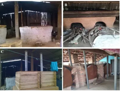
Figure 10 Types of ovens
The rectangular or chorkor ovens are the most widely used with only a hand full still using circular shaped ovens. The dominant construction material of these ovens is mud erected in rectangular or circular shapes (Figure 10, panels A, B). A typical single oven chamber has a height of 62 cm and a width of 140 cm with a life span of 2-3 years. The cost of constructing a local oven made of mud ranges from 20 to 40 Ghana cedis. Other types of ovens were also the Morrison stoves and the new improved ovens made of bricks (Figure 10, panels C, D). Rectangular ovens are most preferred due to the quantity of fish that can be processed at a time. Its disadvantage is the amount of smoke emitted during processing. The Morrison and Kosmos improved ovens were designed to solve this problem with the introduction of
smoking chambers which local ovens lack. The chambers reduce the amount of smoke likely to be inhaled by the fish processor. Adapting to these improved ovens which are more environmentally friendly has been hindered by cost. The cost of building improved ovens is higher than that of the local ovens. Constructing a Morrison oven, for example, can cost over 3,000 Ghana cedis
Local rectangular ovens (chorkor ovens) are overlaid with large sieves or trays made of wooden edges and metal nets placed inside. A typical oven is usually overlaid by 6-10 sieves or trays. These have a capacity to accommodate over 160 kilos of fish. The average cost of acquiring a sieve is about 40 Ghana cedis. The wooden edges of the sieve make them breakable with constant exposure to heat and elements of various weather conditions while the metal nets corrode as they are exposed to sea wind. The easy deterioration of sieves places a burden on limited household income through constant repairs and replacements. One favourable condition helping preserve these ovens and sieves are the processing sheds in
which they are mostly housed. This reduces the impact of sea wind and flood waters on their rate of deterioration. Unfortunately the ovens’ vulnerability to floods is still high despite being housed in processing sheds. This is because the sheds are constructed of wood and have no foundation or base which would prevent the free flow of flood waters into them. Vulnerability of fish processing ovens and processing sheds is also associated with their distances away from water sources.
Figure 11 Distance of processing sheds from sea and high water mark in Axim
More than half of the fish processing sheds in Axim are within the mean high water mark zone. And this constitutes a total of 72 out of the 125 processing sheds mapped (Figure 11). The least distance was 6.2 meters while the farthest distance of processing sheds away from the sea was 185.05 m, with a mean distance of 52 meters away from the sea.
By considering distance from water bodies, elevation and type of building materials used for these ovens/processing sheds, the vulnerability of ovens and processing sheds in Axim is clearly indicated. Thirty- two (32 %) percent of respondents interviewed have had their ovens flooded and destroyed by the sea yearly. Quantification of the cost of these ovens/processing sheds is necessary to appreciate the magnitude of the risk and cost likely to be incurred by these fishing households in case of flood damage.
The processing sheds house an average of 6 ovens, with a total of 750 ovens. The fewest number of ovens owned by a fish processing household was one (1) while large scale fish processors have more than 30 ovens which are housed in processing sheds.
Vulnerability of fish processing households
Socio-economic characteristics of fish processing households are important to understand the overall vulnerability of the fish processing activities in Axim. Household heads involved in
Number of processing sheds
fish processing interviewed had an average monthly income of 362 Ghana Cedis. Such income levels are relatively low considering high dependency in these communities with an average household number of 4 people. Most of the household members are minors with a typical household having 4 members less than 18 years, still under care. This places a huge burden on household heads to meet daily financial needs of dependents with little incomes generated from fish processing.
Engagement in other sources of income not related to the fishing industry is a way of
increasing household resilience level and decreasing vulnerability. Interview data shows 62% of the respondents were solely dependent on fish processing without any diversified
occupation. Those with secondary occupation mostly were in petty trading for subsistence. Savings and loans is one measure to help improve fish processing households. Savings rate was very high in the community considering its rural nature. More than half of the
interviewed respondents were able to save some of the little income generated with Rural Banks. The downside is the high rate of interest on loans charged by Rural Banks where rates can be well over 38% per annum. This deters most respondents from applying for loans in order to boost their fish processing business. Cooperatives tend to have low interest rates than all other financial institutions in the country. But in spite of fishing cooperation
associations in the community, these associations had no financial standings to grant loans to members.
Figure 12 Vulnerability of fish processing households to climate change
Most fish processing households believe their vulnerability levels are increasing with climate change (Figure 12). The major reason ascribed to this increasing vulnerability is dwindling fish catch for processing and rate of destruction of ovens. Other non-climate related reasons given were high cost of transportation and low bargains gotten for smoked fish as the number of people engaged in the business has increased over the years. Considering the perishability of their product, they are compelled to sell at low prices to market women to meet their cost of production and make little revenue. In order to adapt to low incomes and increasing vulnerabilities, some strategies have been adopted by these fish processing households ranging from reducing food quantities previously consumed to others resorting to borrowing from friends and relatives to supplement low incomes for household expenditure.
REFERENCES
Food and Agriculture Organization of the United Nations (2016). FAO soils portal. Accessed on 2 March 2016 on
http://www.fao.org/soils-portal/soil-survey/soil-classification/fao-legend/key-to-the-fao-soil-units/en/
Jongman, B., Winsemius, H. C., Aerts, J. C., de Perez, E. C., van Aalst, M. K., Kron, W., & Ward, P. J. (2015). Declining vulnerability to river floods and the global benefits of adaptation. Proceedings of the National Academy of Sciences, 112(18), E2271-E2280. Tanu, M. (2008). Seasonality of recession time and lag response to precipitation of the
Ankobra and Pra rivers in Ghana, West Africa. 28th Conference on Hurricanes and
Tropical Meteorology, Orlando, Florida.