Received October 30, 2017; Revised December 31 , 2017; Accepted December 31, 2017
This research is a hydrogeological survey with the aim to know the characteristics of groundwater isotope. The research location is Samigaluh area, especially included in West Progo Dome, included in plot of RBI map of Purworejo and Sendangagung Sheet. The area under study is an area that enters in a non-groundwater Basin zone (non CAT). The research method is a field hydrogeology survey, accompanied by taking two groundwater samples for isotope testing. The data required in this study include groundwater and petrological data. Data analysis includes hydrogeological analysis based on isotope data. The results show that the groundwater under study has mild and severe isotope characteristics. The isotope content shows that groundwater flows at relatively close distances and is likely to intermediate. The heavier isotope content indicates a source of recharge water near the eye but at a lower elevation. This is supported by relatively low groundwater TDS content (86 - 108 ppm).
Keywords: hydrogeology, groundwater, stable isotope, O-18, D
1. Introduction
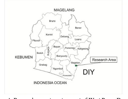
The study of groundwater is conducted in the westernpart of West Progo Dome, which is included in the Indonesian Topographic Map Sheet 1408-231 (Purworejo) [1] and 1408-213 (Bagelen) [2] scale of 1: 25.000, included in Purworejo District (Figure 1). Blekokan and Jolotundo areas become the sample location points that represent the research area.
The author is interested in the field of hydrogeology, especially related to groundwater quality. Several places in Yogyakarta and surrounding areas have been studied groundwater quality problems. This time, the areas included in non CAT West Progo hills in Samigaluh Subdistrict are the object of research study.
Hydrogeological research has been developed in various regions throughout Indonesia to assist the community in terms of water supply. Water is a very vital and strategic need, therefore water must be maintained in adequate quantity and good quality. Potential water in an area includes surface water and groundwater. Both types of water need to know the potential to meet the daily needs of people's lives.
The need for water for the community can be obtained from surface water and groundwater. Surface water can be obtained from rivers, lakes, marshes or seas. Nowadays, surface water is sometimes polluted so groundwater becomes a better alternative to meet the life needs of water. Therefore, the potential of groundwater in an area needs to be assessed so that we can provide water in sufficient quantity and good quality.
2. Methodology
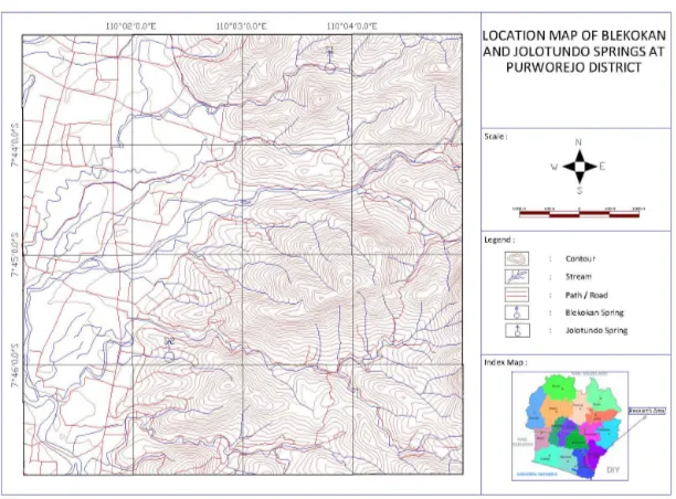
The research was conducted by geological survey method in field, with emphasis of hydrogeology aspect. The tools used are standard geological tools (hammer, loupe, compass) and hydrogeology tools (pH-meter, TDS-meter, and sample bottles). Two groundwater samples were taken with airtight polyethylene bottles, each of 50 ml. Subsequently, groundwater samples tested their isotope content in the Hydrology Laboratory of PAIR-BATAN, Pasar Jum’at, Jakarta. The analysis was conducted on field data including petrology data of aquifer, geomorphology and stratigraphy, and analysis of isotope content of groundwater samples. Groundwater samples were taken at Blekokan wells and Jolotundo springs (Figure 2). Secondary data compilations in the form of regional geological conditions and primary data from the field and laboratory are conducted to explain the hydroisotopic areas studied.
3. Literature Review
3.1. Geological of Research Area
The research area is physiographically included in West Progo Dome Zone. This area is part of the South Serayu Zone physiography [3] especially in the phenomena of the Dome Zone and the Hills in the Central Depression.
Some geologists have discussed West Progo Hills with different approaches such as paleontology analysis, sedimentology, facies, petrology and tectonics. The results of previous researchers concluded that the regional stratigraphy West Progo Hill from the oldest to the young is composed by Nanggulan Formation, Old Andesite Formation, Jonggrangan Formation, Sentolo Formation and Alluvial Deposition. The formation exposed in the research area is the Andesite Old Formation.
The Old Andesite Formation is exposed in the center, north, west and southwest of West Progo Hills. It is deposited in a volcanic environment composed of volcanic breccia, lava, lapili , lapilli tuff and volcanic sandstone. The dominant composite lithology consists of andesite breccia with a tuff matrix, fragments comprising andesite piroksen to andesite hornblende. In addition also revealed the intrusion of igneous rocks.
Figure 2. Groundwater sampling location.
Geological conditions in the West Progo Hills is dominated by materials such as andesite breccia, tuff, lapili, aglomerat, and insertion of andesite lava flows. The material is formed by the existence of ancient volcanic activity at the time tertiary and impermeable (not penetrating water). As a result, the material is not able to store and drain the water so that the groundwater reserves in this region is very minimal. The presence of groundwater in this area is found in very deep layers (> 25 meters) and found only in rock fractures [5]. Fulfillment of the water needs of the population in the hills West Progo in this hilly region generally comes from springs that are found in break of slopes.
3.2. Isotope Theory
Isotopes are elements that have the same atomic number but different mass numbers. An example is the presence of three isotopes of hydrogen: 11H, 12H, 13H. The abundance of isotopes is measured by the standard deviation ratio (Fritz and Fontes, 1980, in [6]). The relationship between δ18O and δD of water precipitation follows the meteoric water line equation.
The process of isotopic fractionation on precipitation is a process that depends on temperature [7]. Thus if there is a change in seasonal temperature in a place there will be a variation in the composition of stable isotope precipitation where mild values occur in cold months. For the same reason precipitation will also have a mild isotope content in the polar regions / high latitudes, in places further away from the sea as well as in places with higher elevations.
Thus, a stable groundwater isotope content can be used for groundwater genetic studies, including to observe groundwater catchment elevations. For example, the area of DKI Jakarta has been proven that the groundwater catchment can come from areas in the south, for example in the area of Mt. Salak and surrounding areas [8].
4. Result and Analysis
Field data is taken directly, especially at locations of both water and dug wells. The groundwater test results in the laboratory are given in Table 1.
turbid (Fig. 3 - 4). According to the information of the inhabitants, this well water only fluctuates but never stopped, with groundwater face only 1 m at the time of sampling.
Figure 3. Blekokan well seen from near distance.
Figure 4. Water condition of Blekokan Well. It has been taken for sample 1.
Figure 5. Jolotundo spring; the water seems rather turbid caused by precipitation several days before sampling. (Sample 2).
Figure 6. Aquifer at Jolotundo spring and surrounding area.
The isotope test results from groundwater samples studied showed a variation of stable isotope content values of O-18 and D (Table 2). Clearly visible variations are found on the content of the O-18 isotope, where there is a fairly mild content in Blekokan (O-18 = -6.9 ‰), whereas groundwater in Jolotundo springs has a heavier O-18 isotope (O-18 = - 4.15 ‰).
The light content of the O-18 isotope shows that groundwater in Blekokan area has 108 ppm TDS, is groundwater not far from recharge area, and experiencing groundwater journey not far. Groundwater is at the start of groundwater travel, and is generally a young groundwater. Blekokan area is a high altitude (170 m elevation), so this area is very potential as a local catchment area for the surrounding area.
Groundwater in Jolotundo (95 m elevation) appears in lower-grade springs, which contain heavier O-18 isotopes, indicating a relatively more distant groundwater journey than groundwater in the Blekokan region. Groundwater in Jolotundo can experience groundwater journey in the intermediate / intermediate phase, approaching the discharge area. Groundwater in this area may have undergone isotopic enrichment, where this process can occur due to the isotopic fractionation as a result of the interaction between rocks and water. However, another possibility that affects the weight of the isotope content in groundwater in Jolotundo is the recharge area not far from the springs, obtained from precipitation in the lowly areas. This is supported by low TDS content in groundwater in this Jolotundo region (86 ppm). Verification of data in the form of chemical data and flow patterns is needed to ensure groundwater genetic in this area.
hydrogeological conditions of the study area are supported by rocks from the Old Andesite Formation, with aquifers in the form of andesite breccia, or clogged lavas. These rocks act as aquifer through the crack porosity. Porosity between grains obtained from the sediment of Quarter or soil result of weathering of volcanic rock. Groundwater in the study area has significant variations of O-18 and D isotopes.
Groundwater in high altitude (Blekokan) contains relatively light O-18 isotope, marking the beginning of groundwater journey in the recharge area, and the distance of groundwater journey that is relatively close. Groundwater in the lowland area (Jolotundo) has a relatively heavier isotope, which is interpreted because it receives recharge water nearby at a lower elevation than the recharge received by groundwater in Blekokan. This is supported by low TDS (86 ppm).
Reference
[1] Bakosurtanal, 2000, Indonesian Topographic Map of Purworejo Sheet, Number 1408-231, 1st Ed., Bakosurtanal, Cibinong.
[2] Bakosurtanal, 1999, Indonesian Topographic Map of Bagelen Sheet, Number 1408-213, 1st Ed., Bakosurtanal, Cibinong.
[3] Van Bemmelen, R.W., 1949, The Geology of Indonesia, Vol. 1A, Martinus Nijhoff, The Hague, Netherland.
[4] Pringgoprawiro, H. & Riyanto, B., 1987, Old Andesite Formation - A Revision, PIT IAGI XVI. Bandung.
[5] Anonim, 2014, General Review of West Progo District, http://www. ppsp.nawasis.info.
[6] Domenico, P.A. dan Schwartz, F.W., 1990, Physical and Chemical Hydrogeology, John Wiley & Son, New York.
[7] Payne, B.R., 1988, The Basic Principles of Isotope Techniques in Hydrology and Examples of Their Application, Centro Internazionale di Idrologia “Dino Tonini”, Universita’ Degli Studi di Padova. [8] Listyani, T., 1999, Oxygen and Hydrogen Isotope Analysis and Its Relation with Saline Groundwater
Genesis in Jakarta Groundwater Basin, Thesis, Bandung Institute of Technology, Bandung, unpublished.
[9] Listyani, 2016, Groundwater Flow and Its Isotopic Evolution in Deep Aquifer of Jakarta Groundwater Basin, Journal of Geological Sciences (JGS) Vol 3, No. 1, E-periodical 2335-6782, GSTF, Singapore.