IndoorGML – A Standard for Indoor Spatial Modeling
(extended abstract)
Ki-Joune Li
Pusan National University, Kumjeong-Gu, Pusan 46241, South Korea – [email protected]
Special Session 18
KEY WORDS: Indoor Spatial Modeling, OGC Standards, IndoorGML
ABSTRACT:
With recent progress of mobile devices and indoor positioning technologies, it becomes possible to provide location-based services in indoor space as well as outdoor space. It is in a seamless way between indoor and outdoor spaces or in an independent way only for indoor space. However, we cannot simply apply spatial models developed for outdoor space to indoor space due to their differences. For example, coordinate reference systems are employed to indicate a specific position in outdoor space, while the location in indoor space is rather specified by cell number such as room number. Unlike outdoor space, the distance between two points in indoor space is not determined by the length of the straight line but the constraints given by indoor components such as walls, stairs, and doors. For this reason, we need to establish a new framework for indoor space from fundamental theoretical basis, indoor spatial data models, and information systems to store, manage, and analyse indoor spatial data. In order to provide this framework, an international standard, called IndoorGML has been developed and published by OGC (Open Geospatial Consortium). This standard is based on a cellular notion of space, which considers an indoor space as a set of non-overlapping cells. It consists of two types of modules; core module and extension module. While core module consists of four basic conceptual and implementation modeling components (geometric model for cell, topology between cells, semantic model of cell, and multi-layered space model), extension modules may be defined on the top of the core module to support an application area. As the first version of the standard, we provide an extension for indoor navigation.
1. INTRODUCTION
We spend most of our daily life in indoor space, which becomes more complex and huge due to urbanization and high density of population but limited territory. It means that spatial information in indoor space is crucial in location-based services as in outdoor space. There are however many and significant differences between indoor and outdoor spaces and they make it difficult to simply apply the geospatial technologies developed for outdoor space to indoor space. The most fundamental difference comes from the spatial reference system, which allows to indicate the location in a space. While coordinate reference system is widely used for outdoor space in the assumption of Euclidean space, it is inappropriate for most applications of indoor spatial information. We rather specify the location of indoor space by a location identifier such as room number. Since indoor space can be no longer considered as a Euclidean space, the definition of distance between two points in indoor space differs from that in outdoor space. We should take into account obstacles or constraints in indoor space to measure the distance in indoor space.
From these observations, we found that it would be required to establish a new framework for indoor space including spatial theory, indoor spatial data model, and indoor spatial information systems. It also includes standard framework to improve interoperability between indoor information systems. For this reason, we have launched a new standard working group in OGC (Open Geospatial Consortium) (OGC 2016) and published a new standard called IndoorGML (OGC 2014) to provide a standard data model and XML schema to represent
and exchange indoor spatial information. IndoorGML is based on cellular space model, which represents a given indoor space with a set of non-overlapping cells in the indoor space. This standard consists of four basic features to describe indoor cellular space; geometry and semantics of indoor cells, topology between indoor cells, and multi-layered space model.
This extended abstract paper explains the basic concepts of IndoorGML with these four features. It is structured as follows. In section 2, we will explain the related work, background, and the requirements of standards for indoor spatial information. In section 3, the cellular space model, which is the key idea of IndoorGML will be presented, and we explain the four features of IndoorGML. We conclude this paper in section 4.
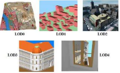
2. BACKGROUND AND REQUIREMENTS IndoorGML is not the first standard dealing with indoor space and there have been several standards for indoor space such as IFC (ISO/TC184/SC4 2013) and CityGML (OGC 2012a). CityGML, an OGC standard for 3D city model as an extension of GML (OGC 2012b) consists of core module, appearance module, and thematic modules such as buildings, transportation, vegetation, etc. And it also provides five LoDs (Level of Detail) and the LoD 4 aims to describe the interior spatial objects of the building module as shown in Figure 1. While CityGML has been developed from a geospatial viewpoint, IFC has been made from construction engineering viewpoint by the International BuildingSmart and ISO (ISO/TC184/SC4 2013) IFC focuses on construction components unlike CityGML. For example, a ceiling is partitioned into multiple small ceilings by The International Archives of the Photogrammetry, Remote Sensing and Spatial Information Sciences, Volume XLI-B4, 2016
XXIII ISPRS Congress, 12–19 July 2016, Prague, Czech Republic
This contribution has been peer-reviewed.
rooms in CityGML, while IFC is interested in describing one single component of ceiling slab with material or texture properties.
Figure 1. Levels of Details in CityGML (OGC 2012a)
Despite differences between IFC and CityGML, they aim to represent building components whether they are indoor or outdoor and fail to meet the requirements from applications of indoor spatial information, which are listed below;
Cellular spatial representation: in indoor space, the location is indicated by a cellular identifier rather than coordinates. For example, when specifying the source and destination for indoor navigation services, we give the room number or symbolic name rather than the coordinates. However, it is implicit or unclear in CityGML and IFC. Topology: for many applications of indoor spatial
information, the topology such as connectivity between two rooms or room and corridor is extremely important. A part of topologies may be represented either in implicit or explicit ways by IFC or CityGML, but it is not complete. Multiple representations of a single indoor space: a
single indoor space can be interpreted in different ways depending on context. For example, the network connectivity of an indoor space depends on the mode of transportation, such as walk or wheelchair. It is difficult to derive these different interpretations of space by IFC or CityGML.
In addition to these requirements, we have also considered the following requirements in developping IndoorGML;
External reference: IndoorGML has been developed to compensate the weakness of previous standards. It means that it is highly recommended to integrate IndoorGML with CityGML, IFC, or even KML. IndoorGML should offer a mechanism to reference to an object defined in other data set in CityGML, IFC, KML, or a database via external reference. For example, when exploring the adjacency topology for emergency response application, we may need the information about material of wall that is not included in IndoorGML. Then we access to the corresponding object in IFC, which includes material information via external reference of IndoorGML.
Interface between indoor and outdoor: although IndoorGML intends to represent indoor objects, we also need to represent objects in outdoor for the integration of indoor and outdoor spaces. For example, when we drive a car into a parking lot in a building, then a seamless integration from outdoor to indoor space is necessary for car navigation service. IndoorGML may provide an interface, whether seamless or not, between indoor and outdoor spaces.
These requirements served as the input of IndoorGML development. In the following sections, we will explain how they have been implemented in IndoorGML.
3. CELLULAR INDOOR SPACE MODEL IndoorGML is based on cellular space model that a given space is divided into a set of cells which are not overlapping. It is defined as follows;
Definition – Indoor Cellular Space Model
A cellular space C of an indoor space U is defined as a set
of cells c such that
i. for any pair of cells ci, cjC ci cj = , ii. ci = U, and
iii. each cell chas a unique identifier c.id
No overlapping between cells is allowed and the union of all cells is a subset of the given indoor space. It means that there may be areas which are not covered by cell and every position does not necessarily belong to cell.
The cellular space concept is a major difference of IndoorGML from its precedents. As shown in Figure 2, IFC or CityGML focus on the representation of indoor components such as walls, doors, and floors while IndoorGML aims to represent the cells bounded by indoor components such as walls, doors, ceilings, and floors. A cell in IndoorGML is a space where objects locate and events happen. Note that walls may be considered as cells since they are also bounded by wall surfaces and some objects such as pipelines can be placed through walls.
Figure 2. Components versus Cells
A cellular configuration of indoor space is called a space layer in IndoorGML. Several space layers can be overlaid in a given space. A big hall of convention center, for example, can be partitioned into small cells in different ways, depending on booth configurations. It means that there are multiple ways of cell configurations of a same indoor space. A key issue in defining cellular space of indoor space is how to partition the space. As shown in Figure 3 (OGC 2010), we suppose that a staircase is found in the middle of a room in the figure, which prevent the navigation of wheelchair, while pedestrians can go through on the staircase. It results in a different interpretation of space that the room with staircase should be divided into two small rooms excluding the area of staircase. IndoorGML offers a mechanism, called Multi-Layered Space$ Model to support
this case with ease.
The International Archives of the Photogrammetry, Remote Sensing and Spatial Information Sciences, Volume XLI-B4, 2016 XXIII ISPRS Congress, 12–19 July 2016, Prague, Czech Republic
This contribution has been peer-reviewed.
In order to complete cellular space model, we need to provide the following aspects that we will explain in the subsequent subsections; geometry of cell, topology between cells, semantics of cells, and multi-layered space model.
Figure 3. Multi-Layered Space Model (OGC 2010)
3.1 Cell Geometry
Cell is a basic unit of the cellular space model and its geometry is defined as a 2 or 3 dimensional spatial object. Since IndoorGML is based on the geometry model defined by ISO 19107 (ISO/TC211 2013), any closed geometry in ISO 19107 may be used in IndoorGML but there are three options to represent cell geometry;
Option 1(no geometry): The first option is to exclude any geometric properties in IndoorGML document and to include only topological relationships between cells, which will be explained in the next subsection.
Option 2 (geometry in IndoorGML): The second option is to represent its geometry within IndoorGML document by geometric types defined in ISO 19107 (ISO/TC211 2013). For example, 3D geometry of a cell is defined as a GM_Solid of ISO 19107.
Option 3 (external reference): The third option is to include external references to object with geometric properties defined in other data set. For example, a cell in IndoorGML document only points to an object in CityGML via GML identifier (OGC 2012b) that contains geometric properties.
Note that these options are not exclusive and may be combined together. For example, while no geometry is included in IndoorGML document (option 1), it contains pointers to objects in external data set (option 2). Furthermore, the geometry defined in IndoorGML is not necessarily identical with the geometry of object in external data set.
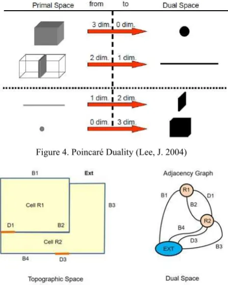
3.2 Topology between cells
Once cell is defined with its identifier and geometric properties, we need to describe the topological relationship between cells, which is essential to most of indoor navigation applications. The topology between cells in IndoorGML is basically derived from topographic layout of indoor space by Poincaré Duality (Lee, J. 2004). As illustrated in Figure 4 (OGC 2010), a k-dimensional object in N-dimensional primal
space is mapped to a (N-k)-dimensional object in dual space.
It means that for example 3-dimensional cell in topographic indoor space is transformed to a 0-dimensional node and 2-dimensional boundary shared by two cells is transformed to 1-dimensional edge in the corresponding dual space. The set of nodes and edges transformed from the primal space by Poincaré
Duality results in a topological graph connecting cells in indoor space. Figure 5 shows an example of adjacency graph derived from a topographic indoor space. From the adjacency graph, we can also derive connectivity graph considering the type of edges of adjacency graph. If the edge indicates a boundary of door, then two ending nodes of this edge are connected, otherwise, they are disconnected. We may define more attributes on edge to represent additional information such as directions and types of doors, etc.
Figure 4. Poincaré Duality (Lee, J. 2004)
Figure 5. Derivation of adjacency graph from topographic indoor space (OGC 2014)
There are two options to represent the graph derived from primal space in IndoorGML. The first option is to include the geometries of node and edge as point and curve respectively. We call graph with geometric properties geometric graph. The
second option is to represent the graph without any geometric properties, called logical graph. However, in most applications
of indoor navigation, we need geometric data to calculate the routing distance. There are several studies to compute optimal path between to point in indoor space (Lu, H., Cao, X., and Jensen, C. S. 2012), (Yuan, W., and Schneider, M. 2010).
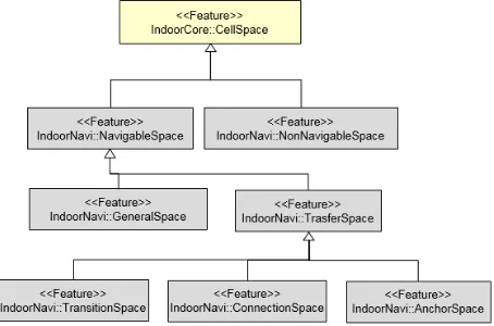
3.3 Cell Semantics
Since every cell in indoor space has its function and usage, which differ from cells in outdoor space, we need to specify the semantics of cells. In the current version of IndoorGML, we classify the types of cells in terms of indoor navigation and expect that other classifications would be necessary for different applications such as indoor facility management. Figure 6 shows the classification of cells. In particular, the anchor node in the figure represents gate or entrance of building and allows to connect indoor and outdoor spaces. Besides the classification of cells, more detail classification of cells and cell boundaries are also defined as attributes. For example, the code list given by OMNI class (AEC 2012) can be used, which defines the hierarchical classification of features in building. The International Archives of the Photogrammetry, Remote Sensing and Spatial Information Sciences, Volume XLI-B4, 2016
XXIII ISPRS Congress, 12–19 July 2016, Prague, Czech Republic
This contribution has been peer-reviewed.
3.4 Multi-Layered Space Model
As briefly mentioned at the beginning of this section, a same indoor space can be interpreted and represented in different ways. In IndoorGML, a mechanism is offered to represent an indoor space with overlaying different interpretations. And each interpretation corresponds to a cellular space layer with its own geometric and topological properties. For example, there are three different layer configurations of an indoor space as shown in figure 7 (OGC 2010); walkable layer, wheelchair layer, and WiFi sensor coverage layer.
Figure 6. Cell Classification (OGC 2014)
Figure 7. Example of Multi-Layered Space Model (OGC 2010)
Since each layer forms a cellular space, it includes geometries of cells, topologies between cells given as a graph, and semantics. In addition to simple aggregation of cellular space layers, a special type of edge, called inter-layered connection,
is also offered in IndoorGML to represent relationships between nodes in different layers. In figure 7, we define room 3 in walkable space layer corresponds with room 3a and room 3b in wheelchair layer because room 3 is partitioned into room 3a and room 3b (OGC 2010). The multi-layered space model is very useful for many applications such as in describing hierarchical structure of indoor space or in tracking moving objects with sensor reading data.
4. CONCLUSION
In this paper, we briefly presented the motivations and basic concepts of IndoorGML, which is an OGC standard for exchaning indoor spatial information. A number of indoor spatial information services has been developed and commercialized since the last decade. We expect that IndoorGML plays a key role in providing interoperability between these services and a data model framework for future development from simple indoor navigation services to complicated indoor spatial analysis and big data analysis.
ACKNOWLEDGEMENTS
This research was partially supported by a grant(14NSIP-B080144-01) from National Land Space Information Research Program funded by Ministry of Land and Transportation of Korean government and BK21PLUS, Creative Human Resource Development Program for IT Convergence
REFERENCES
OGC 2014. OGC IndoorGML, http://www. opengeospa-tial.org/standards/indoorgml
OGC 2016, Open Geospatial Consortium, http://www.open-geospatial.org
ISO/TC184/SC4 2013, Industry Foundation Classes for data sharing in the construction and facility management industries, ISO 16739:2013
OGC 2012a. OGC City Geographic Markup Language Encoding Standard, http://www.opengeospatial.org/standards /citygml
OGC 2012b. OGC Geographic Markup Language-Extended Schemas and Encoding Rules, http://www.opengeospatial. org/standards/gml
OGC 2010. Requirements and Space-Event Modeling for Indoor Navigation, http://portal.opengeospatial.org/files /?artifactid=41727, OGC Discussion Paper 10-l91r1
ISO/TC211 2013, Geographic Information-Spatial Schema, ISO 19107:2003
Lee, J. 2004, A spatial access-oriented implementation of a 3-D GIS topological data model for urban entities, GeoInformatica, 8(3):237-264
Lu, H., Cao, X., and Jensen, C. S. 2012. A foundation for efficient indoor distance-aware query processing, in Proc. ICDE 2012, pp. 438-449
Yuan, W., and Schneider, M. 2010. Supporting Continuous Range Queries in Indoor Space, in Proc. Mobile Data Management, Conference 2010, pp. 209-214
AEC 2012. OmniClass Construction Classification System-Spaces by Functions, http://www.omniclass.org
The International Archives of the Photogrammetry, Remote Sensing and Spatial Information Sciences, Volume XLI-B4, 2016 XXIII ISPRS Congress, 12–19 July 2016, Prague, Czech Republic
This contribution has been peer-reviewed.