Reference number of this OGC® document:
OGC 07-036
Version:
3.2.1
Category: OpenGIS®
Standard
Editor
:
Clemens Portele
OpenGIS® Geography Markup Language (GML) Encoding
Standard
Copyright © 2007 Open Geospatial Consortium, Inc. All Rights Reserved. To obtain additional rights of use, visit http://www.opengeospatial.org/legal/.
Document type:
OpenGIS
®Standard
Document subtype:
Not Applicable
Document stage:
Final
License Agreement
Permission is hereby granted by the Open Geospatial Consortium, ("Licensor"), free of charge and subject to the terms set forth below, to any person obtaining a copy of this Intellectual Property and any associated documentation, to deal in the Intellectual Property without restriction (except as set forth below), including without limitation the rights to implement, use, copy, modify, merge, publish, distribute, and/or sublicense copies of the Intellectual Property, and to permit persons to whom the Intellectual Property is furnished to do so, provided that all copyright notices on the intellectual property are retained intact and that each person to whom the Intellectual Property is furnished agrees to the terms of this Agreement.
If you modify the Intellectual Property, all copies of the modified Intellectual Property must include, in addition to the above copyright notice, a notice that the Intellectual Property includes modifications that have not been approved or adopted by LICENSOR.
THIS LICENSE IS A COPYRIGHT LICENSE ONLY, AND DOES NOT CONVEY ANY RIGHTS UNDER ANY PATENTS THAT MAY BE IN FORCE ANYWHERE IN THE WORLD.
THE INTELLECTUAL PROPERTY IS PROVIDED "AS IS", WITHOUT WARRANTY OF ANY KIND, EXPRESS OR IMPLIED, INCLUDING BUT NOT LIMITED TO THE WARRANTIES OF MERCHANTABILITY, FITNESS FOR A PARTICULAR PURPOSE, AND NONINFRINGEMENT OF THIRD PARTY RIGHTS. THE COPYRIGHT HOLDER OR HOLDERS INCLUDED IN THIS NOTICE DO NOT WARRANT THAT THE FUNCTIONS CONTAINED IN THE INTELLECTUAL PROPERTY WILL MEET YOUR REQUIREMENTS OR THAT THE OPERATION OF THE INTELLECTUAL PROPERTY WILL BE UNINTERRUPTED OR ERROR FREE. ANY USE OF THE INTELLECTUAL PROPERTY SHALL BE MADE ENTIRELY AT THE USER’S OWN RISK. IN NO EVENT SHALL THE COPYRIGHT HOLDER OR ANY CONTRIBUTOR OF INTELLECTUAL PROPERTY RIGHTS TO THE INTELLECTUAL PROPERTY BE LIABLE FOR ANY CLAIM, OR ANY DIRECT, SPECIAL, INDIRECT OR CONSEQUENTIAL DAMAGES, OR ANY DAMAGES WHATSOEVER RESULTING FROM ANY ALLEGED INFRINGEMENT OR ANY LOSS OF USE, DATA OR PROFITS, WHETHER IN AN ACTION OF CONTRACT, NEGLIGENCE OR UNDER ANY OTHER LEGAL THEORY, ARISING OUT OF OR IN CONNECTION WITH THE IMPLEMENTATION, USE, COMMERCIALIZATION OR PERFORMANCE OF THIS INTELLECTUAL PROPERTY.
This license is effective until terminated. You may terminate it at any time by destroying the Intellectual Property together with all copies in any form. The license will also terminate if you fail to comply with any term or condition of this Agreement. Except as provided in the following sentence, no such termination of this license shall require the termination of any third party end-user sublicense to the Intellectual Property which is in force as of the date of notice of such termination. In addition, should the Intellectual Property, or the operation of the Intellectual Property, infringe, or in LICENSOR’s sole opinion be likely to infringe, any patent, copyright, trademark or other right of a third party, you agree that LICENSOR, in its sole discretion, may terminate this license without any compensation or liability to you, your licensees or any other party. You agree upon termination of any kind to destroy or cause to be destroyed the Intellectual Property together with all copies in any form, whether held by you or by any third party.
Except as contained in this notice, the name of LICENSOR or of any other holder of a copyright in all or part of the Intellectual Property shall not be used in advertising or otherwise to promote the sale, use or other dealings in this Intellectual Property without prior written authorization of LICENSOR or such copyright holder. LICENSOR is and shall at all times be the sole entity that may authorize you or any third party to use certification marks, trademarks or other special designations to indicate compliance with any LICENSOR standards or specifications.
This Agreement is governed by the laws of the Commonwealth of Massachusetts. The application to this Agreement of the United Nations Convention on Contracts for the International Sale of Goods is hereby expressly excluded. In the event any provision of this Agreement shall be deemed unenforceable, void or invalid, such provision shall be modified so as to make it valid and enforceable, and as so modified the entire Agreement shall remain in full force and effect. No decision, action or inaction by LICENSOR shall be construed to be a waiver of any rights or remedies available to it.
Warning
OGC official documents use a triple decimal-dot notation (i.e. MM.xx.ss). This document may be identified as MM.xx (Major.minor) and may include increments to the third dot series (schema changes) without any modification to this document, or the version displayed on the document. This means, for example, that a document labelled with versions 1.1.0 and 1.1.1 or even 1.1.9 are exactly the same except for modifications to the official schemas that are maintained and
perpetually located at: http://schemas.opengis.net/. Note that corrections to the document are registered via corrigendums. A corrigendum will change the base document and notice will be given by appending a c# to the version (where # specifies the corrigendum number). In corrigendums that correct both the schemas and the base document, the third triplet of the document version will increment and the ‘c1’ or subsequent identifier will be appended, however the schemas will only increase the third triplet of the version.
Contents
PageForeword ... v
Introduction ... vi
1 Scope ... 1
2 Conformance ... 1
2.1 Conformance requirements ... 1
2.2 Conformance classes related to GML application schemas ... 2
2.3 Conformance classes related to GML profiles ... 2
2.4 Conformance classes related to GML documents ... 5
2.5 Conformance classes related to software implementations ... 5
3 Normative references ... 5
4 Terms and symbols ... 6
4.1 Terms and definitions... 6
4.2 Symbols and abbreviated terms ... 14
5 Conventions ... 15
5.1 XML namespaces ... 15
5.2 Versioning ... 15
5.3 Deprecated parts of previous versions of GML ... 16
5.4 UML notation ... 16
5.5 XML Schema ... 17
6 Overview of the GML schema ... 17
6.1 GML schema ... 17
6.2 GML application schemas ... 18
6.3 Relationship between the ISO 19100 series of International Standards, the GML schema and GML application schemas ... 19
6.4 Organization of this International Standard ... 20
6.5 Deprecated and experimental schema components ... 21
7 GML schema — General rules and base schema components ... 21
7.1 GML model and syntax... 21
7.2 gmlBase schema components ... 23
8 GML schema — Xlinks and basic types ... 35
8.1 Xlinks — Object associations and remote properties ... 35
8.2 Basic types ... 37
9 GML schema — Features ... 46
9.1 General concepts ... 46
9.2 Relationship with ISO 19109 ... 46
9.3 Features ... 46
9.4 Standard feature properties ... 47
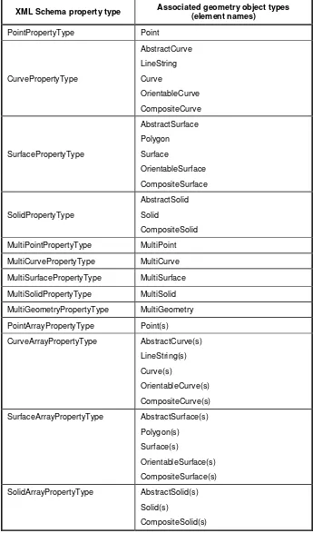
9.5 Geometry properties... 49
9.6 Topology properties ... 51
9.7 Temporal properties ... 51
9.8 Defining application-specific feature types ... 53
9.9 Feature collections ... 53
10 GML schema — Geometric primitives ... 55
10.1 General concepts... 55
10.2 Abstract geometric primitives ... 62
10.3 Geometric primitives (0-dimensional) ... 62
10.4 Geometric primitives (1-dimensional) ... 63
10.5 Geometric primitives (2-dimensional) ... 77
10.6 Geometric primitives (3-dimensional) ... 87
11 GML schema — Geometric complex, geometric composites and geometric aggregates ... 89
11.1 Overview ... 89
11.2 Geometric complex and geometric composites ... 89
11.3 Geometric aggregates ... 92
12 GML schema — Coordinate reference systems schemas ... 97
12.1 Overview ... 97
12.2 Reference systems ... 100
12.3 Coordinate reference systems ... 101
12.4 Coordinate systems ... 110
12.5 Datums ... 118
12.6 Coordinate operations ... 125
13 GML schema — Topology ... 138
13.1 General concepts... 138
13.2 Abstract topology ... 139
13.3 Topological primitives ... 139
13.4 Topological collections ... 144
13.5 Topology complex ... 147
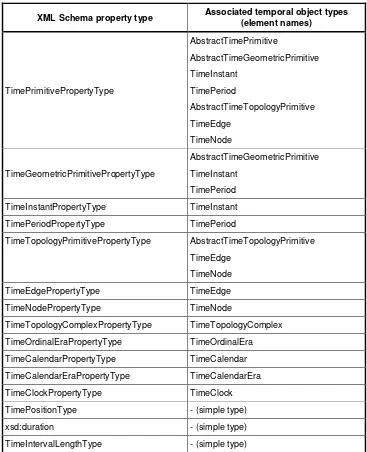
14 GML schema — Temporal information and dynamic features ... 149
14.1 General concepts... 149
14.2 Temporal schema ... 150
14.3 Temporal topology schema ... 159
14.4 Temporal reference systems ... 162
14.5 Representing dynamic features ... 169
15 GML schema — Definitions and dictionaries ... 174
15.1 Overview ... 174
15.2 Dictionary schema ... 174
16 GML schema — Units, measures and values ... 177
16.1 Introduction ... 177
16.2 Units schema ... 178
16.3 Measures schema ... 183
16.4 Value objects schema ... 185
17 GML schema — Directions ... 192
17.1 Direction schema ... 192
17.2 direction, DirectionPropertyType... 192
17.3 DirectionVectorType ... 193
17.4 DirectionDescriptionType ... 193
18 GML schema — Observations ... 195
18.1 Observations ... 195
18.2 Observation schema ... 195
19 GML schema — Coverages ... 199
19.1 The coverage model and representations ... 199
19.2 Grids schema ... 203
20 Profiles ... 223
20.1 Profiles of GML and application schemas ... 223
20.2 Definition of profile ... 223
20.3 Relation to application schema ... 223
20.4 Rules for elements and types in a profile... 223
20.5 Rules for referencing GML profiles from application schemas ... 225
20.6 Recommendations for application schemas using GML profiles ... 225
20.7 Summary of rules for GML profiles ... 226
21 Rules for GML application schemas ... 226
21.1 Instances of GML objects ... 226
21.2 GML application schemas ... 227
21.3 Schemas defining Features and Feature Collections ... 230
21.4 Schemas defining spatial geometries ... 231
21.5 Schemas defining spatial topologies ... 232
21.6 Schemas defining time ... 233
21.7 Schemas defining coordinate reference systems ... 234
21.8 Schemas defining coverages ... 235
21.9 Schemas defining observations ... 237
21.10 Schemas defining dictionaries and definitions ... 238
21.11 Schemas defining values ... 239
21.12 GML profiles of the GML schema ... 239
Annex A (normative) Abstract test suites for GML application schemas, GML profiles and GML documents ... 242
Annex B (normative) Abstract test suite for software implementations ... 258
Annex C (informative) GML schema ... 263
Annex D (normative) Implemented Profile of the ISO 19100 series of International Standards and Extensions ... 265
Annex E (normative) UML-to-GML application schema encoding rules ... 336
Annex F (normative) GML-to-UML application schema encoding rules ... 358
Annex G (informative) Guidelines for subsetting the GML schema ... 368
Annex H (informative) Default styling ... 382
Annex I (informative) Backwards compatibility with earlier versions of GML ... 394
Annex J (informative) Modularization and dependencies ... 412
Bibliography ... 414
Foreword
Attention is drawn to the possibility that some of the elements of this document may be the subject of patent rights. The OGC shall not be held responsible for identifying any or all such patent rights.
Recipients of this document are requested to submit, with their comments, notification of any relevant patent claims or other intellectual property rights of which they may be aware that might be infringed by any implementation of the standard set forth in this document, and to provide supporting documentation.
Introduction
Geography Markup Language is an XML grammar written in XML Schema for the description of application schemas as well as the transport and storage of geographic information.
The key concepts used by Geography Markup Language (GML) to model the world are drawn from the ISO 19100 series of International Standards and the OpenGIS Abstract Specification.
A feature is an ―abstraction of real world phenomena‖ (ISO 19101); it is a geographic feature if it is associated with a location relative to the Earth. So a digital representation of the real world may be thought of as a set of features. The state of a feature is defined by a set of properties, where each property may be thought of as a {name, type, value} triple.
The number of properties a feature may have, together with their names and types, is determined by its type definition. Geographic features with geometry are those with properties that may be geometry-valued. A feature collection is a collection of features that may itself be regarded as a feature; as a consequence a feature collection has a feature type and thus may have distinct properties of its own, in addition to the features it contains.
Following ISO 19109, the feature types of an application or application domain is usually captured in an application schema. A GML application schema is specified in XML Schema and can be constructed in two different and alternative ways:
by adhering to the rules specified in ISO 19109 for application schemas in UML, and conforming to both the constraints on such schemas and the rules for mapping them to GML application schemas specified in this International Standard;
by adhering to the rules for GML application schemas specified in this International Standard for creating a GML application schema directly in XML Schema.
Both ways are supported by this International Standard. To ensure proper use of the conceptual modelling framework of the ISO 19100 series of International Standards, all application schemas are expected to be modelled in accordance with the General Feature Model as specified in ISO 19109. Within the ISO 19100 series, UML is the preferred language by which to model conceptual schemas.
GML specifies XML encodings, conformant with ISO 19118, of several of the conceptual classes defined in the ISO 19100 series of International Standards and the OpenGIS Abstract Specification. These conceptual models include those defined in:
ISO/TS 19103 — Conceptual schema language (units of measure, basic types);
ISO 19107 — Spatial schema (geometry and topology objects);
ISO 19108 — Temporal schema (temporal geometry and topology objects, temporal reference systems);
ISO 19109 — Rules for application schemas (features);
ISO 19111 — Spatial referencing by coordinates (coordinate reference systems);
The aim is to provide a standardized encoding (i.e. a standardized implementation in XML) of types specified in the conceptual models specified by the International Standards listed above. If every application schema were encoded independently and the encoding process included the types from, for example, ISO 19108, then, without unambiguous and completely fixed encoding rules, the XML encodings would be different. Also, since every implementation platform has specific strengths and weaknesses, it is helpful to standardize XML encodings for core geographic information concepts modelled in the ISO 19100 series of International Standards and commonly used in application schemas.
In many cases, the mapping from the conceptual classes is straightforward, while in some cases the mapping is more complex (a detailed description of the mapping is part of this International Standard).
In addition, GML provides XML encodings for additional concepts not yet modelled in the ISO 19100 series of International Standards or the OpenGIS Abstract Specification, for example, dynamic features, simple observations or value objects.
Predefined types of geographic feature in GML include coverages and simple observations.
A coverage is a subtype of feature that has a coverage function with a spatiotemporal domain and a value set range of homogeneous 1- to n-dimensional tuples. A coverage may represent one feature or a collection of features ―to model and make visible spatial relationships between, and the spatial distribution of, Earth phenomena‖ (OGC Abstract Specification Topic 6 [20]) and a coverage ―acts as a function to return values from its range for any direct position within its spatiotemporal domain‖ (ISO 19123).
An observation models the act of observing, often with a camera or some other procedure, a person or some form of instrument (Merriam-Webster Dictionary: ―an act of recognizing and noting a fact or occurrence often involving measurement with instruments‖). An observation is considered to be a GML feature with a time at which the observation took place, and with a value for the observation.
A reference system provides a scale of measurement for assigning values to a position, time or other descriptive quantity or quality.
A coordinate reference system consists of a set of coordinate system axes that is related to the Earth through a datum that defines the size and shape of the Earth.
A temporal reference system provides standard units for measuring time and describing temporal length or duration.
A reference system dictionary provides definitions of reference systems used in spatial or temporal geometries.
Spatial geometries are the values of spatial feature properties. They indicate the coordinate reference system in which their measurements have been made. The ―parent‖ geometry element of a geometric complex or geometric aggregate makes this indication for its constituent geometries.
Temporal geometries are the values of temporal feature properties. Like their spatial counterparts, temporal geometries indicate the temporal reference system in which their measurements have been made.
Spatial or temporal topologies are used to express the different topological relationships between features.
Geographic information
—
Geography Markup Language (GML)
1 Scope
The Geography Markup Language (GML) is an XML encoding in compliance with ISO 19118 for the transport and storage of geographic information modelled in accordance with the conceptual modelling framework used in the ISO 19100 series of International Standards and including both the spatial and non-spatial properties of geographic features.
This International Standard defines the XML Schema syntax, mechanisms and conventions that:
provide an open, vendor-neutral framework for the description of geospatial application schemas for the transport and storage of geographic information in XML;
allow profiles that support proper subsets of GML framework descriptive capabilities;
support the description of geospatial application schemas for specialized domains and information communities;
enable the creation and maintenance of linked geographic application schemas and datasets;
support the storage and transport of application schemas and datasets;
increase the ability of organizations to share geographic application schemas and the information they describe.
Implementers may decide to store geographic application schemas and information in GML, or they may decide to convert from some other storage format on demand and use GML only for schema and data transport.
NOTE If an ISO 19109 conformant application schema described in UML is used as the basis for the storage and transportation of geographic information, this International Standard provides normative rules for the mapping of such an application schema to a GML application schema in XML Schema and, as such, to an XML encoding for data with a logical structure in accordance with the ISO 19109 conformant application schema.
2 Conformance
2.1 Conformance requirements
Clauses 7 to 19 of this International Standard specify XML Schema components, i.e. the GML schema, which shall be used in GML application schemas in accordance with Clause 21. Clause 20 specifies rules for the specification of a GML profile that may be defined for use in a GML application schema.
Most of the schema components specified in this International Standard implement concepts defined in the ISO 19100 series of International Standards. In these cases, the conformance classes defined in this International Standard are based on the conformance classes defined in the corresponding standard.
Any GML application schema, GML profile or software implementation claiming conformance with one of the conformance classes shall pass all test cases of the corresponding abstract test suite.
Any software implementation claiming conformance to this International Standard shall document the GML profile supported by the implementation. The GML profile shall pass all mandatory test cases of the abstract test suite corresponding to GML profiles.
2.2 Conformance classes related to GML application schemas
GML application schemas claiming conformance to this International Standard shall conform to the rules specified in Clauses 7 to 21 and pass all relevant test cases of the abstract test suite in A.1.
Depending on the characteristics of a GML application schema, 12 conformance classes are distinguished. Table 1 lists these classes and the corresponding subclause of the abstract test suite.
Table 1 — Conformance classes related to GML application schemas
Conformance class Subclause of the abstract test suite
All GML application schemas A.1.1
GML application schemas converted from an ISO 19109 application schema in UML A.1.2
GML application schemas to be converted to an ISO 19109 application schema in UML A.1.3
GML application schemas defining features and feature collections A.1.4
GML application schemas defining spatial geometries A.1.5
GML application schemas defining spatial topologies A.1.6
GML application schemas defining time A.1.7
GML application schemas defining coordinate reference systems A.1.8
GML application schemas defining coverages A.1.9
GML application schemas defining observations A.1.10
GML application schemas defining dictionaries and definitions A.1.11
GML application schemas defining values A.1.12
2.3 Conformance classes related to GML profiles
The requirements of an application schema determine the XML Schema components from the GML schema that shall be included in a GML profile. GML profiles claiming conformance to this International Standard shall satisfy the requirements of the abstract test suite in A.2.
Table 2 — Conformance classes related to GML profiles
Conformance class Subclause of the abstract test suite
All GML profiles A.2.1
Geometric primitives (spatial) — 0-dimensional A.2.2.1.1 Geometric primitives (spatial) — 0/1-dimensional A.2.2.1.2 Geometric primitives (spatial) — 0/1/2-dimensional A.2.2.1.3 Geometric primitives (spatial) — 0/1/2/3-dimensional A.2.2.1.4 Geometric complexes (spatial) — 0/1-dimensional A.2.3.1.1 Geometric complexes (spatial) — 0/1/2-dimensional A.2.3.1.2 Geometric complexes (spatial) — 0/1/2/3-dimensional A.2.3.1.3 Topologic complexes (spatial) — 0/1-dimensional A.2.4.1.1 Topologic complexes (spatial) — 0/1/2-dimensional A.2.4.1.2 Topologic complexes (spatial) — 0/1/2/3-dimensional A.2.4.1.3 Topologic complexes with geometric realization (spatial) — 1-dimensional A.2.5.1.1 Topologic complexes with geometric realization (spatial) — 2-dimensional A.2.5.1.2 Topologic complexes with geometric realization (spatial) — 3-dimensional A.2.5.1.3
Coordinate reference systems A.2.6
Coordinate operations between two coordinate reference systems A.2.7
Temporal geometry — 0-dimensional A.2.8.1
Temporal geometry — 0/1-dimensional A.2.8.2
Temporal topology A.2.9
Temporal reference systems A.2.10
Dynamic features A.2.11
Dictionaries A.2.12
Units dictionaries A.2.13
Observations A.2.14
Abstract coverage A.2.15.1
Discrete point coverage A.2.15.2
Discrete curve coverage A.2.15.3
Discrete surface coverage A.2.15.4
Discrete solid coverage A.2.15.5
Grid coverage A.2.15.6
Continuous coverage A.2.15.7
NOTE 1 Compare these conformance classes with ISO 19107:2003, Clause 2, ISO 19108:2002, 2.2, and ISO 19123:2005, Clause 2.
NOTE 2 A GML profile conforming to the three conformance classes ―Geometric primitives (spatial) — 0-dimensional‖,
―Geometric primitives (spatial) — 0/1-dimensional‖, and ―Geometric primitives (spatial) — 0/1/2-dimensional‖ (in addition to
conformance class ―All GML profiles‖) conforms to the spatial profile defined in ISO 19137:2007 and the respective conformance tests in ISO 19137:2007, B.1, B.2 and B.3.
2.4 Conformance classes related to GML documents
GML documents claiming conformance to this International Standard shall conform to the rules specified in Clauses 7 to 21 and pass all relevant test cases of the abstract test suite in A.3.
2.5 Conformance classes related to software implementations
Software implementations reading or writing GML or GML application schemas claiming conformance to this International Standard shall pass all of the corresponding abstract test suites described in the abstract test suite in Annex B.
Depending on the capabilities of the implementation, 11 conformance classes are distinguished. Table 3 lists these classes and the corresponding subclause of the abstract test suite.
Table 3 — Conformance classes related to implementations
Conformance class Subclause of the abstract test suite
All software implementations B.1
Support for remote simple Xlinks B.2.1
Support for extended Xlinks B.2.2
Support for nillable properties B.2.3
Support for units of measurement B.2.4
Support for ownership semantics of properties B.2.5
Metadata properties B.2.6
Support for GML profiles in instance validation B.2.7
Writing GML B.3
Reading GML B.4
Writing GML application schemas B.5
Reading GML application schemas B.6
3 Normative references
The following referenced documents are indispensable for the application of this document. For dated references, only the edition cited applies. For undated references, the latest edition of the referenced document (including any amendments) applies.
ISO/IEC 11404:1996, Information technology — Programming languages, their environments and system software interfaces — Language-independent datatypes
ISO/TS 19103:2005, Geographic information — Conceptual schema language
ISO 19107:2003, Geographic information — Spatial schema
ISO 19108:2002, Geographic information — Temporal schema
ISO 19109:2005, Geographic information — Rules for application schema
ISO 19111:2007, Geographic information — Spatial referencing by coordinates
ISO 19115:2003, Geographic information — Metadata
ISO 19118:2005, Geographic information — Encoding
ISO 19123:2005, Geographic information — Schema for coverage geometry and functions
ISO/TS 19139, Geographic information — Metadata — XML schema implementation
ISO/IEC 19757-3, Information technology — Document Schema Definition Languages (DSDL) — Part 3: Rule-based validation — Schematron
ISO 80000-3, Quantities and units — Part 3: Space and time
IETF RFC 2396, Uniform Resource Identifiers (URI): Generic Syntax (August 1998)
W3C XLink, XML Linking Language (XLink) Version 1.0, W3C Recommendation (27 June 2001)
W3C XML, Extensible Markup Language (XML) 1.0 (Third Edition), W3C Recommendation (4 February 2004)
W3C XML Namespaces, Namespaces in XML, W3C Recommendation (14 January 1999)
W3C XML Schema Part 1, XML Schema Part 1: Structures, W3C Recommendation (2 May 2001)
W3C XML Schema Part 2, XML Schema Part 2: Datatypes, W3C Recommendation (2 May 2001)
4 Terms and symbols
4.1 Terms and definitions
For the purposes of this document, the following terms and definitions apply.
4.1.1
application schema
conceptual schema for data required by one or more applications
4.1.2 association
semantic relationship between two or more classifiers that specifies connections among their instances
[ISO/IEC 19501:2005:]
4.1.3
attribute <XML>
name-value pair contained in an element
NOTE In this document an attribute is an XML attribute unless otherwise specified. The syntax of an XML attribute is
―Attribute::= Name = AttValue‖. An attribute typically acts as an XML element modifier (e.g. <Road gml:id= ―r1‖ />; here gml:id
is an attribute).
4.1.4 boundary
set that represents the limit of an entity
[ISO 19107:2003]
4.1.5
child element <XML>
immediate descendant element of an element
4.1.6 closure
union of the interior and boundary of a topological or geometricobject
[ISO 19107:2003]
4.1.7 codelist
value domain including a code for each permissible value
4.1.8 codespace
rule or authority for a code, name, term or category
EXAMPLE Examples of codespaces include dictionaries, authorities, codelists, etc.
4.1.9
composite curve
sequence of curves such that each curve (except the first) starts at the end point of the previous curve in the sequence
[ISO 19107:2003]
NOTE A composite curve, as a set of direct positions, has all the properties of a curve.
4.1.10
composite solid
connected set of solids adjoining one another along shared boundary surfaces
[ISO 19107:2003]
4.1.11
composite surface
connected set of surfaces adjoining one another along shared boundary curves
[ISO 19107:2003]
NOTE A composite surface, as a set of direct positions, has all the properties of a surface.
4.1.12 coordinate
one of a sequence of n numbers designating the position of a point in n-dimensional space
[ISO 19111:2007]
NOTE In a coordinate reference system, the n numbers shall be qualified by units. 4.1.13
coordinate reference system
coordinate system that is related to an object by a datum
[ISO 19111:2007]
4.1.14
coordinate system
set of mathematical rules for specifying how coordinates are to be assigned to points
[ISO 19111:2007]
4.1.15
coordinate tuple
tuple composed of a sequence of coordinates
[ISO 19111:2007]
4.1.16 coverage
feature that acts as a function to return values from its range for any direct position within its spatial, temporal or spatiotemporal domain
[ISO 19123:2005]
4.1.17 curve
1-dimensional geometric primitive, representing the continuous image of a line
[ISO 19107:2003]
NOTE The boundary of a curve is the set of points at either end of the curve. If the curve is a cycle, the two ends are identical, and the curve (if topologically closed) is considered to not have a boundary. The first point is called the start point, and the last is the end point. Connectivity of the curve is guaranteed by the ―continuous image of a line‖ clause. A topological theorem states that a continuous image of a connected set is connected.
4.1.18 data type
specification of a value domain with operations allowed on values in this domain
[ISO/TS 19103:2005]
EXAMPLE Integer, Real, Boolean, String, Date (conversion of data into a series of codes).
4.1.19 datum
parameter or set of parameters that define the position of the origin, the scale, and the orientation of a coordinate system
[ISO 19111:2007]
NOTE A datum may be a geodetic datum, a vertical datum, an engineering datum, an image datum or a temporal datum.
4.1.20
direct position
position described by a single set of coordinates within a coordinate reference system
[ISO 19107:2003]
4.1.21 domain well-defined set
[ISO/TS 19103:2005]
NOTE 1 A mathematical function may be defined on this set, i.e. in a function f:AB, A is the domain of the function f.
NOTE 2 A domain as in domain of discourse refers to a subject or area of interest.
4.1.22 edge
1-dimensional topological primitive
[ISO 19107:2003]
4.1.23
element <XML>
basic information item of an XML document containing child elements, attributes and character data
NOTE From the XML Information Set: ―Each XML document contains one or more elements, the boundaries of which are either delimited by start-tags and end-tags, or, for empty elements, by an empty-element tag. Each element has a type,
identified by name, sometimes called its ‗generic identifier‘ (GI), and may have a set of attribute specifications. Each attribute
specification has a name and a value.‖
4.1.24 exterior
difference between the universe and the closure
[ISO 19107:2003]
4.1.25 face
2-dimensional topological primitive
[ISO 19107:2003]
NOTE The geometric realization of a face is a surface. The boundary of a face is the set of directed edges within the same topology complex that are associated to the face via the boundary relations. These may be organized as rings.
4.1.26 feature
[ISO 19101:2002]
NOTE A feature may occur as a type or an instance. The term ―feature type‖ or ―feature instance‖ should be used when only one is meant.
4.1.27
feature association
relationship that links instances of one feature type with instances of the same or a different feature type
[ISO 19110:2005]
4.1.28 function
rule that associates each element from a domain (source, or domain of the function) to a unique element in another domain (target, co-domain, or range)
[ISO 19107:2003]
4.1.29
geodetic datum
datum describing the relationship of a 2- or 3-dimensional coordinate system to the Earth
[ISO 19111:2007]
4.1.30
geometric object
spatial object representing a geometric set
[ISO 19107:2003]
4.1.31
geometric primitive
geometric object representing a single, connected, homogeneous element of space
[ISO 19107:2003]
4.1.32
geometric set
set of direct positions
[ISO 19107:2003]
4.1.33
geometry property <GML>
property of a GML feature that describes some aspect of the geometry of the feature
NOTE The geometry property name is the role of the geometry in relation to the feature.
4.1.34
GML application schema
4.1.35
GML document
XML document with a root element that is one of the elements AbstractFeature, Dictionary or TopoComplex specified in the GML schema or any element of a substitution group of any of these elements
4.1.36 GML profile
subset of the GML schema
4.1.37
GML schema
schema components in the XML namespace ―http://www.opengis.net/gml/3.2‖ as specified in this International Standard
4.1.38 grid
network composed of two or more sets of curves in which the members of each set intersect the members of the other sets in an algorithmic way
[ISO 19123:2005]
NOTE The curves partition a space into grid cells.
4.1.39 interior
set of all direct positions that are on a geometric object but which are not on its boundary
[ISO 19107:2003]
4.1.40 line string
curve composed of straight-line segments
4.1.41
measure <GML>
value described using a numeric amount with a scale or using a scalar reference system
NOTE When used as a noun, measure is a synonym for physical quantity.
4.1.42 measurand
particular quantity subject to measurement
4.1.43
namespace <XML>
collection of names, identified by a URI reference, which are used in XML documents as element names and attribute names (W3C XML Namespaces)
4.1.44 node
0-dimensional topological primitive
[ISO 19107:2003]
4.1.45 object
[ISO 19107:2003]
NOTE A GML object is an XML element of a type derived from AbstractGMLType.
4.1.46
observable type
data type to indicate the physical quantity as a result of an observation
4.1.47 point
0-dimensional geometric primitive, representing a position
[ISO 19107:2003]
NOTE The boundary of a point is the empty set.
4.1.48 polygon
planar surface defined by 1 exteriorboundary and 0 or more interiorboundaries
4.1.49
property <GML>
a child element of a GML object
NOTE It corresponds to feature attribute and feature association role in ISO 19109. If a GML property of a feature has an xlink:href attribute that references a feature, the property represents a feature association role.
4.1.50
physical quantity
quantity used for the quantitative description of physical phenomena
[ISO 31-0:1992]
NOTE In GML a physical quantity is always a value described using a numeric amount with a scale or using a scalar reference system. Physical quantity is a synonym for measure when the latter is used as a noun.
4.1.51 range
set of all values a function f can take as its arguments vary over its domain
4.1.52 rectified grid
grid for which there is an affine transformation between the grid coordinates and the coordinates of an external coordinate reference system
[ISO 19123:2005]
4.1.53 schema
formal description of a model
[ISO 19101:2002]
4.1.54
schema <XML Schema>
collection of schema components within the same target namespace
EXAMPLE Schema components of W3C XML Schema are types, elements, attributes, groups, etc.
4.1.55
schema document <XML Schema>
XML document containing schema component definitions and declarations
NOTE The W3C XML Schema provides an XML interchange format for schema information. A single schema document provides descriptions of components associated with a single XML namespace, but several documents may describe components in the same schema, i.e. the same target namespace.
4.1.56
semantic type
category of objects that share some common characteristics and are thus given an identifying type name in a particular domain of discourse
4.1.57 sequence
finite, ordered collection of related items (objects or values) that may be repeated
[ISO 19107:2003]
4.1.58 set
unordered collection of related items (objects or values) with no repetition
[ISO 19107:2003]
4.1.59
spatial object
object used for representing a spatial characteristic of a feature
[ISO 19107:2003]
4.1.60 surface
2-dimensional geometric primitive, locally representing a continuous image of a region of a plane
NOTE The boundary of a surface is the set of oriented, closed curves that delineate the limits of the surface. Surfaces that are isomorphic to a sphere, or to an n-torus (a topological sphere with n―handles‖) have no boundary. Such surfaces are
called cycles.
[ISO 19107:2003]
4.1.61 tag <XML>
markup in an XML document delimiting the content of an element
EXAMPLE <Road>
4.1.62
topological object
spatialobject representing spatial characteristics that are invariant under continuous transformations
[ISO 19107:2003]
4.1.63 tuple
ordered list of values
NOTE The number of values in a tuple is immutable.
4.1.64
UML application schema
application schema written in UML in accordance with ISO 19109
4.1.65
Uniform Resource Identifier (URI)
unique identifier for a resource, structured in conformance with IETF RFC 2396
NOTE The general syntax is <scheme>::<scheme-specific-part>. The hierarchical syntax with a namespace is <scheme>://<authority><path>?<query> — see RFC 2396.
4.2 Symbols and abbreviated terms
The following symbols and abbreviated terms are used in this document:
CRS Coordinate Reference System
CS Coordinate System
CSV Comma Separated Values
CT Coordinate Transformation
DTD Document Type Definition
EPSG European Petroleum Survey Group
GIS Geographic Information System
GML Geography Markup Language
NOTE The acronym GML was previously used in ISO also as Generalized Markup Language (which led to SGML, Standard Generalized Markup Language, ISO 8879).
HTTP Hypertext Transfer Protocol
IETF Internet Engineering Task Force
ISO International Organization for Standardization
RDF Resource Description Framework
RFC Request for Comments
SMIL Synchronized Multimedia Integration Language
SOAP Simple Object Access Protocol
SVG Scalable Vector Graphics
UML Unified Modeling Language
URI Uniform Resource Identifier
URL Uniform Resource Locator
URN Uniform Resource Name
W3C World Wide Web Consortium
WFS Web Feature Service
XML eXtensible Markup Language
XSLT eXtensible Stylesheet Language — Transformations
0D Zero Dimensional
1D One Dimensional
2D Two Dimensional
3D Three Dimensional
5 Conventions
5.1 XML namespaces
All components of the GML schema are defined in the namespace with the identifier
"http://www.opengis.net/gml/3.2", for which the prefix gml or the default namespace is used within this International Standard.
All components described by the W3C Xlink Recommendation are defined in the namespace with the identifier "http://www.w3.org/1999/xlink", for which the prefix xlink is used within this International Standard.
NOTE The schema components in both namespaces are documented in XML Schema documents in Annex C.
5.2 Versioning
NOTE This is the first version of GML as an International Standard. Previous versions of GML have been developed and published by the Open Geospatial Consortium (OGC).
5.3 Deprecated parts of previous versions of GML
The verb ―deprecate‖ provides notice that the referenced portion of this International Standard is being retained for backwards compatibility with earlier versions but may be removed from a future version without further notice.
Sections of this International Standard that describe or refer to deprecated GML components are written in italics.
NOTE 1 This International Standard is published by the Open Geospatial Consortium as GML 3.2.1, the previous adopted version of GML in the Open Geospatial Consortium was 3.1.1.
NOTE 2 All schema components that were part of version 2.1 of GML but were deprecated in version 3.0 of GML have been removed and are not supported by this International Standard.
5.4 UML notation
Many diagrams that appear in this International Standard are presented using the Unified Modeling Language (UML) static structure diagram. The UML notations used in this International Standard are described in Figure 1.
Figure 1 — UML notation
<<DataType>> is a set of properties that lack identity (independent existence and the possibility of side effects). A DataType is a class with no operations whose primary purpose is to hold the information.
<<Union>> is a set of properties. The semantics is that only one of the properties may be present at any time.
<<FeatureType>> is a feature as defined in ISO 19109.
<<CodeList>> is a flexible enumeration that uses string values for expressing a list of potential values.
<<Enumeration>> is a fixed list of valid identifiers of named literal values. Attributes of an enumerated type may only take values from this list.
<<Abstract>> is an abstract object type (the stereotype is used in addition to formatting the class name in italics).
<<Type>> is a set of abstract attributes and associations. Abstract means that their specification does not imply that they have to be concretely implemented as instance variables.
In this International Standard, the following standard data types are used:
CharacterString — A sequence of characters (in general this data type is mapped to ―string‖ in XML Schema).
Integer — An integer number (in general this data type is mapped to ―integer‖ in XML Schema).
Real — A floating point number (in general this data type is mapped to ―double‖ in XML Schema).
Boolean — A value specifying TRUE or FALSE (in general this data type is mapped to ―boolean‖ in XML Schema).
5.5 XML Schema
The normative parts of this International Standard use the W3C XML Schema language to describe the grammar of conformant GML data instances. XML Schema is a rich language with many capabilities and subtleties. While a reader who is unfamiliar with XML Schema may be able to follow the description in a general fashion, this International Standard is not intended to serve as an introduction to XML Schema. In order to have a full understanding of this International Standard it is necessary for the reader to have a reasonable knowledge of XML Schema.
6 Overview of the GML schema
6.1 GML schema
GML specifies XML encodings of a number of the conceptual classes defined in the ISO 19100 series of International Standards and the OpenGIS Abstract Specification in conformance with these standards and specifications.
The relevant conceptual models include those defined in:
ISO/TS 19103 — Conceptual schema language (units of measure, basic types);
ISO 19108 — Temporal schema (temporal geometry and topology, temporal reference systems);
ISO 19109 — Rules for application schemas (features);
ISO 19111 — Spatial referencing by coordinates (coordinate reference systems);
ISO 19123 — Schema for coverage geometry and functions (coverages, grids).
In many cases, the mapping from the conceptual classes to XML is straightforward, while in some cases the mapping is more complex. For both cases, the mapping is documented in detail in Annex D.
In addition, GML provides XML encodings for additional concepts not yet modelled in the ISO 19100 series of International Standards or the OpenGIS Abstract Specification. Examples include moving objects, simple observations or value objects. Additional conceptual classes corresponding to these extensions are also specified in Annex D.
The GML schema comprises the components (XML elements, attributes, simple types, complex types, attribute groups, groups, etc.) that are described in this International Standard. The XML encoding conforms to ISO 19118.
6.2 GML application schemas
Designers of GML application schemas may extend or restrict the types defined in the GML schema to define appropriate types for an application domain. Non-abstract elements, attributes and types from the GML schema may be used directly in an application schema, if no changes are required.
Following ISO 19109, the feature types of an application or application domain are specified in an application schema. A GML application schema shall be specified in XML Schema and import the GML schema. It may be constructed in one of two different ways:
By adhering to the rules for GML application schemas specified in Clause 21 for creating a GML application schema directly in XML Schema.
By adhering to the rules specified in ISO 19109 for application schemas in UML, and conforming to both the constraints on such schemas and the rules for mapping them to GML application schemas specified in Annex E of this International Standard. The mapping from an ISO 19109 conformant Application Schema in UML to the corresponding GML application schema is based on a set of encoding rules. These encoding rules conform with the rules for GML application schemas and ISO 19118.
Both ways are valid approaches to construct GML application schemas. All application schemas shall be modelled in accordance with the General Feature Model specified in ISO 19109. Within the ISO 19100 series, UML is the preferred language to describe conceptual schemas.
The second approach is recommended in general to ensure proper use of the conceptual modelling framework of the ISO 19100 series of International Standards. However, the following reasons are examples where it may be justified to apply the first approach:
Additional capabilities of the GML schema may be required in addition to the capabilities that are accessible by using the encoding rules specified in Annex E.
Only an XML representation may be required and the application schema may be relatively simple, so the use of a conceptual schema language may be considered an unjustified overhead.
NOTE Annex F provides rules for mapping a GML application schema to an ISO 19109 conformant Application Schema in UML.
In both cases, GML application schemas conformant with this International Standard shall use all of the applicable GML schema components, either directly or by specialization, and are valid in accordance with the rules for XML Schema. How the GML application schemas were produced is not relevant for conformance to the requirements of this International Standard.
6.3 Relationship between the ISO 19100 series of International Standards, the GML schema
and GML application schemas
The approach taken by this International Standard is shown in Figure 2. The two main aspects are:
Clear documentation of the conceptual model of GML: The profile of the ISO 19100 series of International Standards that is implemented by GML is documented as well as the extensions to this profile.
Support for application schema development either in UML or XML Schema: In order to achieve this two-way mapping between UML (i.e. ISO 19109 conformant application schemas in UML) and XML Schema (i.e. GML application schemas in XML Schema) the constructs used in both representations have been limited. While this reduces the expressiveness of the schema descriptions to some extent, this also reduces their complexity and may make them easier to implement.
Figure 2 — Relationship between the ISO 19100 series of International Standards and ISO 19136/GML
6.4 Organization of this International Standard
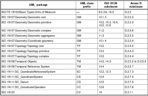
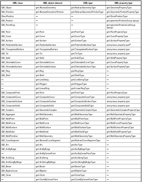
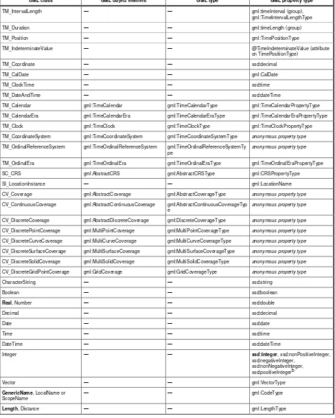
GML defines the various entities such as features, geometries, topologies etc. through a hierarchy of GML object types. The mapping between GML object types and classes in the conceptual model of the ISO 19100 series of International Standards and the OGC Abstract Specification is shown in Table D.2. The normative GML schema is organized around these object types.
Subclause 7.2 describes basic schema components of GML. It defines the root object, gml:AbstractObject, and the root of the GML class hierarchy, gml:AbstractGML.
Subclause 8.1 describes the Xlink schema. This schema is an OGC implementation of the XLink specification using XML Schema. It may be replaced in some future release by an equivalent schema from the W3C.
NOTE 1 Within this International Standard an XML Schema description is provided for xlink components. This is provided for convenience in the context of an XML Schema-based environment. The normative definitions are given a non-XML Schema form in the XLink Recommendation.
Subclause 8.2 defines the GML representation of some basic data types that are used in the GML schema. Most of these types are simple types or simple content types.
Clause 9 describes the feature schema components which defines gml:AbstractFeature and some derived components.
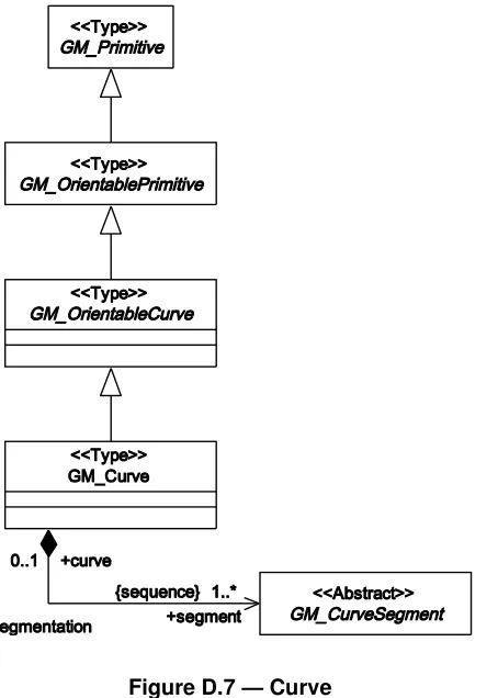
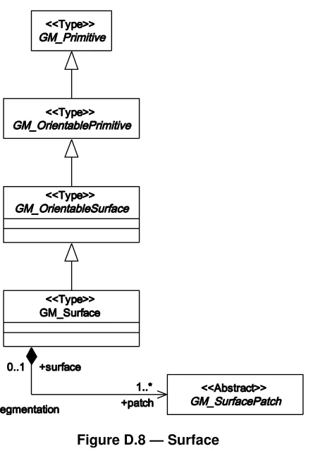
Clause 10, 10.5.10 and Clause11 describe the geometry schema components that define
gml:AbstractGeometry, gml:AbstractGeometricPrimitive, gml:AbstractGeometricAggregate,
gml:GeometricComplex and some derived components.
Clause 12 describes the coordinate reference system schema components that define the subtypes of
gml:IdentifiedObject, gml:AbstractCRS, gml:AbstractCoordinateReferenceSystem, and the elements and types required to construct specific coordinate reference systems.
Clause 13 describes the schema components for topology which define gml:AbstractTopology,
gml:AbstractTopoPrimitive, gml:TopoComplex and some derived components.
Clause 14 describes the schema components for temporal constructs defining gml:AbstractTimeObject,
gml:AbstractTimePrimitive, gml:AbstractTimeGeometricPrimitive,
gml:AbstractTimeTopologyPrimitive, gml:AbstractTimeComplex and derived components as well as
gml:DynamicFeature and derived components.
Clause 15 describes the schema components for definitions and dictionaries including gml:Definition and
gml:Dictionary.
Clause 16 describes the schema components for the construction of units of measure (gml:UnitDefinition
and derived components), measures and value objects (gml:AbstractValue, gml:AbstractScalarValue,
gml:AbstractScalarValueList and derived components).
Clause 17 describes the schema components for the description of direction.
Clause 19 describes the schema components for grids and coverages. This describes gml:Grid,
gml:AbstractCoverage, gml:AbstractDiscreteCoverage, gml:AbstractContinuousCoverage and derived components.
These clauses describe the normative GML schema and explain their contents, structure and dependencies.
The representation of the GML schema presented in this International Standard uses the XML interchange format provided by W3C XML Schema. The descriptions of the set of components are factored into schema documents, where each document gathers together components that correspond broadly to the classification shown in Figure 2. However, while the XML representation of each GML schema component in this International Standard is normative, the packaging into schema documents is not. Clause 20 (profiles) and Annex G (subsetting) describe principles and methods for alternative packaging of the XML representation of GML schema components.
All components defined or declared in this International Standard use the same target namespace of http://www.opengis.net/gml/3.2.
NOTE 2 XML namespaces provide a mechanism for avoiding ambiguity arising from name clashes within XML documents. All components described in a single schema document are in a single target namespace, but more than one schema document may describe components in a namespace. Within the XML development community there are precedents for assigning either one or several namespaces to a set of schema components for a single application. The use of a single namespace for GML schema components is consistent with the non-normative factoring of the XML representation of GML components between schema documents.
UML uses packages to collect related components. Furthermore, within the ISO 19100 series of International Standards, prefixes following the pattern "AA_" are used to distinguish classes from different packages in a way that resembles XML namespaces. However, for the reasons given above, packaging of GML components is non-normative and all GML components are in a single namespace, so no correspondence between the two letter prefixes in the ISO 19100 series of International Standards and XML namespaces in GML is possible.
6.5 Deprecated and experimental schema components
Experimental, informative schema components dealing with rules for a default styling of GML objects are described in Annex H.
Deprecated global schema components (elements, attributes, types) are included in Annex I.
7 GML schema
—
General rules and base schema components
7.1 GML model and syntax
7.1.1 GML instance documents
GML uses an explicit syntax to instantiate a GML application schema conformant with the General Feature Model defined in ISO 19109 in an XML document.
A feature is encoded as an XML element with the name of the feature type. Other identifiable objects are encoded as XML elements with the name of the object type.
Each feature attribute and feature association role is a property of a feature. Feature properties are encoded in an XML element.
Furthermore, the property semantics, which is indicated by the name of the element representing the property, is distinguished from the property value, which is given by the content of the property element. A property element may contain its value as content encoded inline, or reference its value with a simple XLink. The value of a property may be simple, or it may be a feature or other complex object. When recorded inline, the value of a simple property is recorded as a literal value with no embedded markup (text), while if the value is complex it appears as a subtree using XML markup (i.e. an XML element with sub-structure).
NOTE 2 The GML model has a straightforward representation using the UML profile used in the ISO 19100 series of International Standards (defined in ISO/TS 19103). This is described in detail in Annex D and Annex E, but can be summarized approximately and briefly as follows.
Features are represented
in UML by objects, where the name of the feature type is used as the name of the object class;
in GML instances by XML elements, where the name of the feature type is used as the name of the element.
Feature properties are represented
in UML by association roles with feature type classes, and attributes of feature type classes, where the property semantics are given by the association role name or attribute name;
in GML instances by sub-elements (known as property elements) of feature elements, where the property semantics are given by the property element name.
The property value has a type indicated
in UML by the class of the association target, or by the data type of the attribute;
in GML, in the case of properties with complex values, by the name of the object element contained within the property element and in case of a property with simple value by the type of the literal value containing no embedded XML markup.
The result is a layered XML document, in which XML elements corresponding to features, objects or values occur interleaved with XML elements corresponding to the properties that relate them. The function of a feature, object or value in context can always be determined by inspecting the name of the property element which directly contains it, or which carries the reference to it.
NOTE 3 This encoding pattern is sometimes referred to as the ―object-property model‖ and has been the basis of the GML encoding model since the first version was adopted by OGC. While in some cases this encoding pattern adds extra levels of elements in instance documents it also provides significant benefits: It helps to make a GML instance document understandable on its own, provides a predictable structure and avoids too heavy reliance on XML Schema as it is expected that GML instance documents may outlive the common use of W3C XML Schema language.
7.1.2 Lexical conventions
There are several lexical conventions used in the GML schema for the names of elements and complex types to assist in human comprehension of GML instances and schemas:
objects are instantiated as XML elements with a conceptually meaningful name in UpperCamelCase;
properties are instantiated as XML elements whose name is in lowerCamelCase;
abstract elements have a prefix ―Abstract‖ (objects) or ―abstract‖ (properties) prepended to their name;
abstract XML Schema complex types have the word ―Abstract‖ prepended.
It is strongly recommended to follow these conventions also in GML application schemas. The rules are only applicable in languages that distinguish between upper and lower case.
NOTE UpperCamelCase is a naming convention in which a name is formed of multiple words that are joined together as a single word with the first letter of each of the multiple words capitalized within the new word that forms the name. lowerCamelCase is a variation in which the first letter of the new word is lower case, allowing it to be easily distinguished from an UpperCamelCase name.
7.1.3 XML Schema definition of GML language
The GML schema consists of W3C XML Schema components that define types and declare
XML elements to encode GML objects with identity,
XML elements to encode GML properties of those objects, and
XML attributes qualifying those properties.
A GML object is an XML element of a type derived directly or indirectly from gml:AbstractGMLType. From this derivation, a GML object shall have a gml:id attribute.
A GML property shall not be derived from gml:AbstractGMLType, shall not have a gml:id attribute, or any other attribute of XML type ID.
An element is a GML property if and only if it is a child element of a GML object.
A GML object shall not appear as the immediate child of a GML object.
Consequently, no element may be both a GML object and a GML property.
All XML attributes declared in the GML schema are defined without namespace, the only exception is the gml:id
XML attribute.
NOTE The use of additional XML attributes in a GML application schema is discouraged.
7.2 gmlBase schema components
7.2.1 Goals of base schema components
The gmlBase schema components establish the GML model and syntax, in particular
a root XML type from which XML types for all GML objects should be derived,
a pattern and components for GML properties,
patterns for collections and arrays, and components for generic collections and arrays,
components for associating metadata with GML objects,
NOTE The corresponding schema document in Annex C is identified by the following location-independent name (using URN syntax):
urn:x-ogc:specification:gml:schema-xsd:gmlBase:3.2.1
7.2.2 Base objects
7.2.2.1 AbstractObject
An abstract convenience element gml:AbstractObject is declared as follows:
<element name="AbstractObject" abstract="true"/>
This element has no type defined, and is therefore implicitly (in accordance with the rules of W3C XML Schema) an XML Schema anyType. It is used as the head of an XML Schema substitution group which unifies complex content and certain simple content elements used for datatypes in GML, including the gml:AbstractGML
substitution group.
NOTE gml:AbstractObject is defined primarily to act as a variable in certain aggregate patterns where it is necessary to allow either elements in the gml:AbstractGML substitution group, or certain complex content or simple content elements to be valid in an instance.
A GML dataset (also called a data instance or data document) is represented by an object element. This object may in turn be a collection of GML objects.
7.2.2.2 AbstractGML, AbstractGMLType
The most basic components for representations of identifiable objects are described in the schema as follows:
<element name="AbstractGML" type="gml:AbstractGMLType" abstract="true" substitutionGroup="gml:AbstractObject"/>
<complexType name="AbstractGMLType" abstract="true"> <sequence>
<group ref="gml:StandardObjectProperties"/> </sequence>
<attribute ref="gml:id" use="required"/> </complexType>
<group name="StandardObjectProperties"> <sequence>
<element ref="gml:metaDataProperty" minOccurs="0" maxOccurs="unbounded"/> <element ref="gml:description" minOccurs="0"/>
<element ref="gml:descriptionReference" minOccurs="0"/> <element ref="gml:identifier" minOccurs="0"/>
<element ref="gml:name" minOccurs="0" maxOccurs="unbounded"/> </sequence>
</group>
The abstract element gml:AbstractGML is ―any GML object having identity‖. It acts as the head of an XML
Schema substitution group, which may include any element which is a GML feature, or other object, with identity. This is used as a variable in content models in GML core and application schemas. It is effectively an abstract superclass for all GML objects.