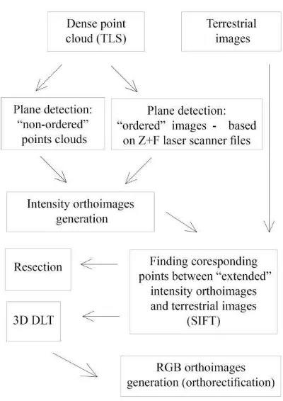
isprsarchives XL 5 W4 393 2015
Teks penuh
Gambar


Garis besar
Dokumen terkait
Umur kontrak biasanya lebih dan satu tahun sehingga disebut sebagai kontrak jangka panjang Dalam korrtr"at< tersebut tertera besarnya harga atau nilai kontrak yanE
This report discusses the diversity of problems between urban centres and surrounding ecosystems through an overview of water related disasters in the Vu Gia – Thu Bon basin,
HASIL TRANSFORMASI SKALA ORDINAL MENJADI SKALA
Pada pengakuan awal, aset atau liabilitas keuangan diukur pada nilai wajar, kecuali untuk aset dan liabilitas keuangan yang diukur pada nilai wajar melalui laporan
Berdasarkan penjelasan diatas, bahwa tugas akhir dengan judul “ Game Adventure Treasure Of Mouse ” penulis dapat menarik beberapa kesimpulan sebagai berikut :..
Dilihat dari gambaran umum dukungan keluarga dalam. memanfaatkan layanan kesehatan maternal
(1) Penyerahan Prasarana, Sarana dan Utilitas dilakukan dengan Berita Acara Serah Terima dari Pihak Ketiga kepada Pemerintah Daerah.. Berita Acara Serah Terima Administrasi; dan
Menetapkan : PERATURAN BUPATI TENTANG PEMBENTUKAN, SUSUNAN ORGANISASI, TUGAS POKOK, URAIAN TUGAS JABATAN DAN TATA KERJA SANGGAR KEGIATAN BELAJAR PADA DINAS
