The Model of Land Cover Change into Settlement Area and Tin
Mining and its Affecting Factors in Belitung Island, Indonesia
Dedi Hermon1* Paus Iskarni2 Olivia Oktorie3 Ratna Wilis4
1.Head of Geography Education Master Program also Lecturer of Geography and Post Graduate Program of and Head of Study Center for Population and Society Aspiration,
Universitas Negeri Padang, INDONESIA
2. Head of Spatial Data Infrastructur Development Center and Lecturer of Geography and Postgraduate Program of Universitas Negeri Padang, INDONESIA
3.Graduate of Geography Education Master Program, Faculty of Social Sciences, Universitas Negeri Padang, INDONESIA
4.Lecturer of Geography Department, Faculty of Social Sciences, Universitas Negeri Padang, INDONESIA
Abstract
The purpose of this research is to formulate model of land cover change into settlement area and tin mining area and to formulate factors influencing the land cover change in Belitung Island during 1995-2015 period. Formulating model of land cover change into settlement and tin mining area in Belitung Island during 1995-2015 period is done by using the interpretation of Landsat Image 5+TM year 1995 and Landsat Image 7+ETM year 2015 with GIS-ENVI 5.1 and GIS-ERDAS 9.1 using tools analysis supervised classification. The analysis of land cover change (ha) during 1995-2015 period (20 years) is done by using converted ENVI 5.1 with GIS-ERDAS 9.1 of tools GIS Analysis Matrix. The factors affecting land cover change into settlement and tin mining area in Belitung Island during 1995-2015 period are found out by formulating population social model. The data tabulation of land cover change data analysis (ha) are dependent variables which are then associated with independent variables as the representative of population and social characteristics analyzed with SPSS 15. The method is arranged by using multiple regression analysis technique with forward stepwise regression method. The interpretation results of Landsat Image 5+TM year 1995 and Landsat Image 7+ETM year 2015 show that the change of forest cover into settlement area is 59,840.07 ha, tin mined land/shrubs land into settlement area is 4,511.04 ha, the forest into tin mining area active is 46,122.44 ha, tin mined land/shrubs into active tin mining lands is 352.13 ha, and water/lake former tin mine land into active tin mining lands is 18,417.03 ha. The change of land cover into settlement area in Belitung Island during 1995-2015 period is consistently influenced by the factor of MINER_X5 positively. On the other hand, change of land cover into tin mining area active is
consistently affected by MF_X2 and MINER_X5 positively.
Keywords: Land Cover, Settlement Area, Tin Mining
1. Introduction
Land cover change is a major issue in global environmental change (Hermon, 2013 and Hermon, 2014). The analysis of land cover changes using satellite imagery is very effective to use because it is able to provide good information about all land cover changes on earth surface, which is very useful in mapping land cover patterns and changes over time (Sarma et al., 2001 and Hermon, 2015). Land cover change is a phenomenon that is very difficult to overcome quickly and precisely. This is due to the development carried out directly urging the natural lands to change function (Hermon, 2009). As the region develops, greater pressure on lands and areas classified as forests converted into settlement and industrial area also mining activities will result in increased CO2
percentages in the atmosphere (Hermon, 2010; Hermon, 2014; Hermon, 2015; Hermon, 2016a; Hermon, 2016b;
Hermon, 2017). The increasing percentage of CO2 in the atmosphere directly affects climate conditions, causing
extreme weather symptoms (Hermon, 2012; Hermon, 2013; Hermon, 2014b; Hermon, 2016a). The occurrence of
extreme weather symptoms within a region will trigger land damage and disaster, especially floods, landslides, forest and land fires, land degradation, drought and other hydro meteorological disasters (Hermon, 2016a; Hermon, 2016b; Hermon, 2016c).
Changes in land cover are generally influenced by human factors on the land management (Hermon, 2009). The change of land cover in Belitung Island is very complex, especially the change of land cover into settlement area. In addition, tin mining activities also trigger land cover changes on a wide scale for tin mining. The change of forest land cover into tin mining in Belitung Island is generally done by people who own the lands and work as tin miners in tin companies. This phenomenon has emerged since 1990 when tin companies on the Belitung Island began to reduce the production due to the impact of land and environmental damage that already reached the limit (Hermon, 2016a).
(Megawandi, 2013). Furthermore, Widyamiko (2012) adds that since 1990, tin mining industry has faced complex problems such as land clearing by traditional miners or better known as UM mines (unconventional mines), underdeveloped downstream, reopening of former mining land into new mining areas managed in traditional manner by society, so that Belitung Island experiencing more severe environmental damage, marked by the emergence of extreme weather symptoms due to very reduced percentage of forest area in Belitung Island, river and coastal pollution by the waste of mining process, sedimentary estuary, loss of mangroves as the balancing of coastal and marine environmental sustainability, flooding, forest and land fires, and tornadoes
(Sapanli, 2009; Widyatmiko, 2012; Hermon, 2016a). WALHI (2013) also explains about land cover changes into
settlement area and tin mining that happen uncontrolled and do not refer to the Spatial Layout Law will cause the utilization of land that is no longer in accordance with its allocation, so that the environmental damage in Belitung Island is getting worse.
The environmental and forest destruction that occurred in Belitung Island was started in 1998, when the community initiated to conduct traditional and illegal mining processes, known as unconventional tin mining (UM). UM is a mining activity that does not pay attention to environmental conservation and violates the law because it generally does not have a mining permit, but provides a substantial income for people who are engaged in illegal mining. (Elfida, 2007; Sapanli, 2009). The occurrence of changes in forest cover into uncontrolled tin mining and settlement area in Belitung Island is the result of the Regional Spatial Layout Law and the Spatial Layout Law of the Island that is not used as the reference for the designation of the area in Belitung Island by the community and local government (Erman, 2007; Resosudarmo and Subiman, 2010;
Sidabukke, 2011; Hayati, 2011; Bastida and Paramita, 2013). Hermon (2016a) explains that the change of land
cover into settlement area in Belitung Island during the period of 1995-2015 is 59,840.07 ha, and forest land into tin mining is 46,122.44 ha. The changes continue to occur constantly due to the increasing number of tin miners as well as the government policies of Belitung Regency and East Belitung Regency also the provincial government of Bangka Belitung Islands that are not responsive to the sustainability of natural resources and environment. Based on this, formulating a model of land cover change into settlement area and tin mining during 1995-2015 period in Belitung Island is needed, so that it can spatially provide information on changing indicators, as well as a reference to formulate factors that affect the land cover change into settlement area and tin mining in Belitung Island during 1995-2015 period.
2. Research Method
2.1. Model of Land Cover Change During 1995-2015 Period in Belitung Island
The spatial model formulation of land cover change into residential and tin mining area in Belitung Island during 1995-2015 period is done by the interpretation of Landsat Image year 1995 and 2015. The interpretation of Landsat Image refers to the image interpretation done by Zain (2002) modified and developed by Hermon (2009);
Hermon (2012); Hermon, (2014a), Hermon (2015); And Hermon (2016a) by interpreting Landsat Image 5+TM
year 1995 and Landsat Image 7+ETM year 2015 with GIS-ENVI 5.1 for band change and fusion to be analyzed. The classification of land cover is done by using GIS-ERDAS 9.1 with tools analysis supervised classification for each image, so that six land cover patterns are formulated: (1) forest, (2) settlement, (3) cultivation, (4) tin mining area active, (5) tin mined land/shrubs, and (6) water/lake former tin mine. The analysis of land cover change (ha) during 1995-2015 period (20 years) is done by using converted GIS-ENVI 5.1 with GIS-ERDAS 9.1 of tools GIS Analysis Matrix.
2.2. Factors Affecting Land Cover Change into Settlement and Tin Mining Area Active During 1995-2015 Period in Belitung Island
(Ezekiel and Fox, 1959). The resulting model is: y = ao + a1x1 + a2x2 + a3x3 + ... + anxn
Where:
y : dependent variable (estimated variable);
x : independent variable (estimator variable);
a: regression coefficient
In formulating the equation model above, the independent variables chosen are those that match the characteristics of the study area.
3. Result and Discussion
3.1. Model of Land Cover Change During 1995-2015 Period in Belitung Island
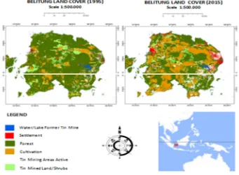
Analysis results of Belitung Island Landsat Image 5+TM year 1995 and Landsat Image 7+ETM year 2015 show that there has been a change in every land cover: forest, cultivation, settlement, tin mining area active, tin mined land/shrubs, and water/lake former tin mine. Spatial model of land cover change during 1995-2015 period in Belitung can be seen in Figure 1.
Figure 1. Model of Land Cover Change During 1995-2015 Period In Belitung Island, Indonesia (Hermon, 2016a)
Hermon (2016a) explains that in 1995, the area of land cover in Belitung Island was 236,114.21 ha of forest, 110,090.02 ha of cultivation, 25,430.11 ha of settlement area, 5,111.24 ha of tin mining area active, 73,844.21 ha of tin mined land/shrubs, and 29,420.24 ha of water/lake former tin mine. In 2015, the area of land cover in Belitung Island was 50.154,67 ha of forest, 190,088.01 ha of cultivation, 89,781.22 ha of settlement area, 70,001,05 ha of tin mining area active, 68,981,05 ha of tin mined land/shrubs, and 11,003.21 ha of water/lake former tin mine (Table 1).
Table 1. Land Cover Change During 1995-2015 Period in Belitung Island, Indonesia
Land Cover Year 1995
(ha)
Year 2015 (ha)
Change 1995-2015 (ha)
Forest 236.114,21 50.154,67 - 185.959,54
Cultivation 110.090,02 190.088,01 + 79.994,03
Settlement 25.430,11 89.781,22 + 64.351,11
Tin Mining Area Active 5.111,24 70.001,05 + 64.890,60
Tin Mined Land/Shrubs 73.844,21 68.981,05 - 4.863,16
Water/Lake Former Tin Mine 29.420,24 11.003,21 - 18.417,03
Total 480.010.000 480.010.000
Source: Hermon (2016a)
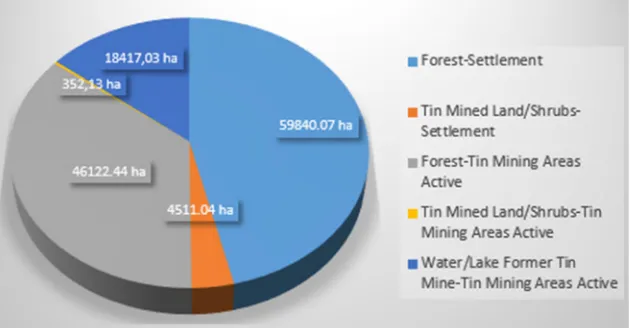
of tin mined land/shrubs, and 18.417.03 ha of lake former tin mining. On contrary, for the increased are 79,994.03 ha of cultivation, 64,351.11 ha of settlement, and 64,890.60 ha of tin mining area active (Hermon, 2016a). The extent of land cover change into settlement area and tin mining during 1995-2015 period in Belitung Island can be seen in Figure 2.
Figure 2. Extent of Land Cover Change into Settlement and Tin Mining Area During 1995-2015 Period in Belitung Island, Indonesia
Source: Analysis Results of Landsat Matrix ETM 7+ Landsat 1995 and 2015 With ERDAS 9.1 (2017)
The land cover changes into settlement and tin mining area active in Belitung Island during 1995-2015 period vary greatly, where the change of forest cover into settlement area is 59,840.07 ha, and tin mined land/shrubs into settlement area is 4,511.04 ha. On contrary, the changes of forest into tin mining area active is 46,122.44 ha, tin mined land/shrubs into tin mining area active is 352.13 ha, and water/lake former tin mine into an active tin mining lands is 18,417.03 ha. Based on the results of image analysis for 2 year dot, it is obtained data of land cover change for 20 years, which is between 1995 until 2015. This data then plotted become dependent variable from equation model which is arranged to find out the factors affecting to land cover change.
3. 2. Factors Affecting Land Cover Change into Settlement and Tin Mining Area During 1995-2015 Period in Belitung Island
a. Factors Affecting Forest Land Cover Change into Settlement and Tin Mining Area Actve During 1995-2015 Period in Belitung Island
The analysis result of forest land cover change into settlement area for the period of 1995-2015 in Belitung Island shows that this model is able to describe the diversity of the dependent variable, where R2 is 95.3%. The analysis result of partial test on the selected independent variables shows that some significant variables from the largest beta value to the smallest with 95% confidence interval, i.e HF (X1), MINER (X5), and WORK (X3).
Table 2. Analysis Result of Multiple Regressions for Forest Land Changes into Settlement Area in Belitung Island During 1995-2015 Period
Regression Summary for Dependent Variable : FOREST-SETTLEMENT AREA R2 = .953
BETA B Std.Error of B t p-level
Intercpt -56.467 14.462 -3.904 0.017
X1 1.012 0.004 0.000 7.582 0.002
X2 -0.276 -0.098 0.082 -1.191 0.298
X3 0.435 0.825 0.293 2.819 0.048
X4 -0.595 -0.701 0.263 -2.661 0.056
X5 0.903 2.800 0.509 5.498 0.005
Source: Data Analysis Results (2017)
The function of causal relation between forest land changes into settlement area during 1995-2015 period in Belitung Island is as follows:
y = -56,467 + 1,012X1 + 0.435X3 + 0,903X5
Where: y = extent of forest land change into settlement area
The HF (X1) factor has a positive effect on the change of forest land cover into settlement area by 1.012
(P <0.05). This shows that the increase of each unit of the head of family will increase the change of forest land into settlement area by 1,012 times. In addition, the MINER factor (X5) also positively affects the change of
forest land cover into settlement area by 0.903 (P <0.05). The WORK (X3) factor also positively influences the
percentage unit of land owner and miner will increase the change of forest cover into settlement area in Belitung Island during 1995-2015 period by 0.435 times.
b. Change of Tin Mined Land/Shrubs into Settlement Area During 1995-2015 Period in Belitung Island
The analysis result of tin mined land/shrubs change into settlement area shows that this model is also quite capable of describing the diversity of the dependent variable, where R2 is 98.7%. The analysis result of partial test on the selected independent variables shows that some significant variables from the largest beta value to the smallest with 95% confidence interval, i.e MINER (X5), WORK (X3), RENT (X6), and POP (X7).
Table 3. Analysis Result of Multiple Regressions for Land Changes of Tin Mined Land/Shrubs into Settlement Area in Belitung Island During 1995-2015 Period
Regression Summary for Dependent Variable : TIN MINED LAND/SHRUBS-SETTLEMENT AREA R2 = .987
Where: y = the extent of tin mined land/shrubs change into settlement area
The MINER factor (X5) has a positive effect on the change of tin mined land/shrubs into settlement area
by 0.831 (P <0.05), where each increase of one percentage unit of the UM traditional miners will increase the change of tin mined land/shrubs into settlement area in Belitung Island during 1995-2015 period by 0.831 times. The OWNER factor (X4) also gives a positive effect by 0.480 (P <0.05) on the change of the former mining/bush
land cover into a settlement area, so that each increase of one percentage of landowners will increase the tin mined land/shrubs into settlement area in Belitung Island during 1995-2015 period by 0.480 times.
c. Change of Forest Land into Tin Mining Area Active During 1995-2015 Period in Belitung Island
The analysis result of forest land cover change into tin mining area active shows that this model is also able to describe the diversity of dependent variables, where R2 is 96.6%. The analysis result of partial test on the selected independent variables shows that some significant variables from the largest beta value to the smallest with 95% confidence interval, i.e MINER (X5), HF (X1), MF (X2), and POP (X7).
Table 4. Analysis Result of Multiple Regressions for Forest Land Change into Tin Mining Area Active 1995-2015 Period in Belitung Island
The function of causal relation between forest land change into tin mining area active during 1995-2015 period in Belitung Island is as follows:
y = 22,677 – 0,640X1 – 1,726X3 – 1,269X7 + 0.077X2 + 1,678X5
Where: y = extent of forest land change into tin mining Area Active
The MINER factor (X5) has a positive effect on the change of forest land cover into tin mining area
active by 1.678 (P <0.05), where each increase of one unit percentage of UM illegal miners will increase the change of forest land into tin mining area active during 1995-2015 period in Belitung Island by 1,678 times. In addition, the MF factor is also a positive influence by 0.007 (P 0.05), meaning that each increase of one percentage unit of the miner's family will increase the change of forest land into active tin mining in Belitung Island during 1995-2015 period 2015 by 0.007 times.
The analysis result of the change of the former tin / bush land cover into the tin mining area active indicates that this model is also able to describe the diversity of the dependent variable, where R2 is 92.3%. The results of partial test analysis of the selected independent variables can be known some significant variables from the
largest beta value to the smallest with 95% confidence interval, namely MINING (X5), OWNER (X4), and MF
(X2).
Table 5. Analysis Result of Multiple Regressions for Land Changes of Tin Mined Land/Shrubs into Tin Mining Area Activein Belitung Island During 1995-2015 Period
Regression Summary for Dependent Variable : TIN MINED LAND/SHRUBS-TIN MINING AREA ACTIVE
The function of causal relation between change of tin mined land/shrubs into tin mining area active during 1995-2015 period in Belitung Island is as follows:
y = 11,214 + 0,510 X4 + 1,924X5 - 0,832X9
Where: y = the extent of the tin mined land/shrubs change into tin mining area active
The MINER factor (X5) has a positive effect by 1,924 (P <0.05) on the change of tin mined land/shrubs
into tin mining area active during 1995-2015 period in Belitung Island. This means that each increase of one unit percentage of the number of UM illegal miners will increase the change of tin mined land/shrubs into active tin mining by 1,924 times. The OWNER factor (X7) also positively influences the change of the tin mined
land/shrubs into tin mining area active by 0,510 (P <0.05). While PRE factor (X9) gives negative effect by 0,832
(P <0,05) to change of tin mined land/shrubs into tin mining area active.
e. Change of Lake Former Tin Mine into Tin Mining Area Active During 1995-2015 Period in Belitung Island The analysis result of water/lake former tin mine change into tin mining area active for the period of 1995-2015 in Belitung Island shows that this model is able to describe the diversity of the dependent variable, where R2 is 99.8%. The analysis result of partial test on the selected independent variables shows that some significant variables from the largest beta value to the smallest with 95% confidence interval, i.e MINER (X5), OWNER
(X4), WORK (X3), POP (X7), HF (X1), and MF (X2).
Tabel 6. Analysis Result of Multiple Regressions for Land Changes of Water/Lake Former Tin Mine into Tin Mining Area Active During 1995-2015 Period in Belitung Island
Regression Summary for Dependent Variable : WATER/LAKES TIN MINE-TIN MINING AREA ACTIVE R2
= .998
The function of causal relation between water/lake former tin mine change into tin mining area active period 1995-2015 in Belitung Island is as follows:
y = -17.703 - 2,306X1 + 0.848X3 + 1,069X2 + 0,938 X4 + 1,507X5 + 0,698X7
Where: y = the extent of change of lake former tin mine into tin mining area active
The MINER factor (X5) has a positive effect on the water/lake former tin mine change into tin mining
area active by 1.507 (P <0.05), where each increase of one unit percentage of UM illegal miners will increase the water/lake former tin mine change into tin mining area active by 1,507 times. The MF Factor (X2) also has a
positive effect by 1.069 (P <0.05) on the water/lake former tin mine change into tin mining area active. The OWNER factor (X4) also positively influences the water/lake former tin mine change into tin mining area active
in Belitung Island by 0.938 (P <0.05). The WORK (X3) factor also has a positive effect by 0.848 (P <0.05) on
the water/lake former tin mine change into tin mining area active. The POP factor (X7) gives a positive effect by
negative effect on the water/lake former tin mine change into an tin mining area active by 2,306 (P <0,05). The change of land cover into settlement area in Belitung Island during 1995-2015 period is consistently influenced by the MINER factor X5 positively, whereby the greater percentage of UM illegal miners
will lead to greater land cover changes into settlement area. On the other hand, the change of land cover into tin mining area active in Belitung Island Belitung Island during 1995-2015 period is consistently influenced by MF_X2 and MINER_X5 positively, where the greater percentage of miner families and UM illegal miners will
cause the change of land cover into tin mining area active is also getting bigger.
Hermon (2009); Ngonyo and Owyer (2017) explain that the change of land cover into settlement area is generally caused by several factors, namely: (1) nature or intrinsic of land resources, in accordance with the principle of supply-demand economy law experiencing the scarcity structure as a result of increasing demand for land for the purpose settlement area that contribute to encouraging the conversion of non-forest land use, and (2) government policies that provide big investment opportunities for industrial and mining sectors, but investment rates in the industrial and mining sectors are still not followed by the rate of legislation stipulation and legislation which can be used as a reference in controlling land cover changes.
4. Conclusion
Changes in forest cover to into residential and tin mining area in Belitung Island in the period 1995-2015 have been very alarming and uncontrolled. Reduction of forest land into settlement area is 59,840.07 ha, while the reduction of forest land due to tin mining area active is 46,122.44 ha. The occurrence of changes in forest cover and other land cover into residential and tin mining area is generally due to the increasing number of traditional UM illegal miners in Belitung Island since 1990. The characteristics of tin mining managed by UM miners are categorized in illegal mining that does not refer to government regulations and the sustainability of natural resources and environment.
References
Bastida, A.E. and Parmita, D. (2013). ‘Legal Baseline Review Tin Mining Sector in Indonesia’. ITRI Bangka Erman, E. (2007). ‘Deregulation of Tin Trade and Creation of Local Shadow State’, A Bangka Case Study. Di
dalam: Nordholt NS, Klinken G, editor. Renegotiating Boundaries Local Politics in Post-Suharto Indonesia; Leiden: KITLV Press. pp 177–202
Elfida. (2007). ‘Spatial Pattern Analysis of People Tin Mining As Input in Spatial Policy Determination in Bangka Regency’. Bogor Agricultural Institute (in Indonesian)
Ezekiel, M. and K.A. Fox. (1959). ‘Methods of Correlation and Regression Analysis’. John Wiley & Sons, Inc. New York
Hayati, T. (2011). ‘Mining Licensing in Reformation Era of Studied Local Government on Tin Mining Permit in Bangka Island’. Dissertation. UI. Indonesia (in Indonesian)
Hermon, D. (2009). ‘Settlement Areas Dynamics and Alternative Policy of Settlement Development in Landslide Prone Areas in Padang City’. Dissertation. PSL. IPB. Bogor (in Indonesian)
Hermon, D. (2011). ‘Geography of Environment’. UNP Press. Padang (in Indonesian)
Hermon, D. (2012). ‘Hydro Meteorological Disaster Mitigation’. UNP Press. Padang (in Indonesian)
Hermon, D. (2013). ‘Dynamics of Carbon Stock based on Land Cover Change Into Settlement Areas in Padang City’. Forum Geografi. Vol. 26: 45-52 (in Indonesian)
Hermon, D. (2014a). ‘Impacts of Land Cover Change on Climate Trend in Padang, Indonesia’. International Journal of Geography. Vol. 46: 138-142
Hermon, D. (2014b). ‘Geography of Natural Disasters’. Raja Grafindo Persada. Jakarta (in Indonesian)
Hermon, D. 2015. Estimate of Changes in Carbon Stocks Based on Land Cover Changes in The Leuser Ecosystem Area (LEA) Indonesia. Forum Geografi. Vol. 29: 187-196
Hermon, D. (2016a). ‘The Changes of Carbon Stocks and CO2 Emission as The Result of Land Cover Change
for Tin Mining and Settlement in Belitung Island Indonesia’. Journal of Geography and Earth Sciences. Vol. 4: 17-30
Hermon, D. (2016b).’ Climate Change Mitigation’. Raja Grafindo Persada. Jakarta (in Indonesian)
Hermon, D. (2016c). ‘The Strategic Model of Tsunami Based in Coastal Ecotourism Development at Mandeh Regions, West Sumatra, Indonesia’. Journal of Environmental and Earth Sciences. IISTE. Vol. 6: 40-45
Hermon, D. (2017). ‘Climate Change Mitigation’. RajaGrafindo Persada. Jakarta
Megawandi, Y. (2013). ‘Economic Development Transformation of Bangka Belitung Islands Province’. In: ITRI Indonesia Tin Forum; 2013 Dec 11; Bangka, Indonesia (in Indonesian)
Ngonyo, M and C. Owyer. (2017). ‘A Study of The Evolution and Growth of Public Relation Practice in Kenya’. IJSBAR. Vol. 33: 1-14
Aziz IJ, editor. Sustainable Development: The Role and Contributions of Emil Salim. Jakarta: Popular Gramedia Library. pp 426-449 (in Indonesian)
Sapanli, K. (2009). ‘Analysis of Maritime Economic Development Policy in the Province of Bangka Belitung Islands’. Bogor Agricultural Institute (in Indonesian)
Sidabukke, M. (2011). ‘Unlicensed Tin mining in Protected Forest Area Case Study of Protected Forest Area of Gunung Sepang, Bangka Belitung Regency’. University of Indonesia (in Indonesian)
Widyatmiko, R.B. (2012). ‘Development of Sustainable Area in Bangka Belitung Islands Province’. Case Study of Economic Transformation of Area Based on Tin Mining. Dissertation. IPB. Bogor (in Indonesian) [WALHI] Wahana Lingkungan Hidup Indonesia(Indonesian Forum for Environment). (2013). ‘Let's Make
Bangka-Belitung Better’. In: ITRI Indonesia Tin Forum; 2013 Dec 11; Bangka, Indonesia (in Indonesian)
Zain, A.F.M. (2002). ‘Distribution, Structure dan Function of Urban Green Space in Southeast Asian Mega-Cities with Special Reference to Jakarta Metropolitan Region (JABOTABEK)’. Doctoral Degree Program. Department of Agricultural and Environmental Biology Graduate School of Agricultural and Life Sciences. The University of Tokyo. Japan
Dedi Hermon (September 24, 1974) Born on September 24, 1974 in Padang, West Sumatra, Indonesia. Doctoral graduate of Natural Resources and Environmental Management in Bogor Agriculture University, Indonesia (2009). Head of irrigation projects at Punjung Island, West Sumatra, Indonesia (2011-2013), and Head of the Disaster Research Center and Environment of Universitas Negeri Padang (2014-2019). Also Head of Geography Education Master Program at Padang State University (2003-2017). Active as a researcher of environment, disasters, and carbon stocks. The results of the study have published in international journals
Paus Iskarni (May 12, 1963) Born in Pasaman, West Sumatra, Indonesia. Doctoral graduate of Population Sciences at Universitas Gajah Mada (2005). Active as a researcher of population and policy researches within the National Population Agency. Currently active as a lecturer in Geography and Postgraduate Department of Universitas Negeri Padang, Indonesia
Olivia Oktorie (October 17, 1980) Born in Bukitinggi, West Sumatra, Indonesia. Master graduate of Geography Education, Faculty of Social Sciences, Universitas Negeri Padang, Indonesia (2016). Active as an environmental and disaster researcher at the Center for Disaster and Environmental Studies, and the Center for Population and Aspiration Studies of the Community, Master of Geography Education Program, Universitas Negeri Padang, Indonesia