Fig. E V
1.1 Relief o surface CHAPTER
I
After stud forms of e
Endogenetic
Volcanism
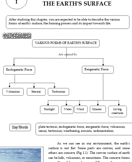
of the earth's e is not flat. dying this ch
arth's surfa VA c Force Seism p s
THE
hapter, you ace, the formARIOUS FO
mic Te
Sunlight plate tecton seism, tecto surfa othe can b are form earth
Are caus
FOR
E EART
are expecte ming procesORMS OF EA
ectonism
t Wate
nic, endogen onism, weat
As we c ace is not ers are conc
be hills, vol valleys, lak ms of the ear In this c h's surface a
Socia
ed by
RMS O
TH'S S
ed to be abl ss and its im
ARTH'S SU
E
er Wind
netic force, e thering, ero
can see in flat. Some ave (Fig 1.1 lcanoes, or kes, and oc rth's surface chapter you and the pro
l Sciences
OF
SURFA
e to describ mpact towar URFACE Exogenetic F Glacier exogenetic sion, sedim our enviro parts are 1). The conv
mountains. ceans. Why e?
u will learn ocess of land
Chapter 1
ACE
be the variou rds life.
Force
r Liv
crea force, volca mentation. onment, th convex, an vex surface . The conca y are there
n various f dforms.
1
us ving tures anism, e earth's nd some e of earth ave forms e variousSocial Sciences Chapter 1
2
A. STRUCTURE OF THE EARTH
Earth is one of the planets in the Solar System. In the beginning of its form, earth
was a celestial body which was blazing and very hot. After millions of years, the earth
became much colder. The outer layer of the earth, its skin, is frozen, but the inner side,
the erth's core, is still very hot. The outer layer that has been frozen is called
earth's crustor
earth's skin (Fig. 1.2).D
C
B
C
A
Fig. 1.2 The inside structure of the earth
Legend:A = Inner core, radius 1,300 km. Density = 12 – 15. B = Outer core, thickness 2,100 km. Density = 8 – 12. C = Mantle, thickness 2,900 km. Density = 3 – 8. D = Crust, thickness 4 – 80 km. Density = 2.6 – 3.0.
The core of our earth is a massive thick liquid which is very hot. It consists of
nickel (Ni) and iron (Fe). The temperature in the earth center is approximately 2,500°C.
The mantle is a dense, hot layer of semisolid (plasticlike liquid) rock. The earth's crust
has a lower density than the hot layer liquid underneath it. Therefore, the earth's crust is
floating on the mantle.
The earth's crust that becomes the bottom part of the oceans is called oceanic plate
Social Sciences Chapter 1
3
Mini Laboratory
fire
Fig. 1.3 Convection experiment in boiling water
B. PLATE TECTONICS THEORY
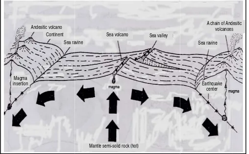
A process similar to Fig. 1.3 also takes places inside the earth. Constant heating from the inner core layer of the earth causes convection on the mantle layer. The flow of convection current from the mantle layer will continuously hit the earth crust. The crust will gradually curve upwards. If the curved crust is still bumped by the convection current, it will eventually crack or break. The broken crust (called fault) will finally be dragged by the convection current just like the piece of wood put into the pan with boiling water inside. The theory about the process of moving the earth crust (plate) which is caused by the influence of convection current is called plate tectonics theory. Pay attention to Fig. 1.4.
On Fig. 1.4 we can see the broken crust will be moved by the convection current. The right fault will move to the right and the left fault will move to the left. Because the broken plates are continuously moving, the oceanic plate will finally bump into the continental plate.
If an oceanic plate crashes into a continental plate, generally the oceanic plate will thrust or move downwards. In a certain depth, the oceanic plate will melt because of the heat of mantle layer. The melting oceanic plate will turn into magma and emits energy. If this happens continuously, there will be loads of magma and energy which may bring about the following things:
Water current
Water current
In front of the class, your teacher has heated some water in a pan until it is boiling. Some fried tea leaves have been dropped into the water. Observe the movement of the water current. After each group observes the esperiment, please discuss the following questions:
1. Where is the source for heating placed?
2. Based on your observation, to what direction are the tea leaves moving? 3. If a piece of wood is put into the
middle of water, in which direction will it move?
`
Fig. Fig Magm insert1. Magma and the 2. If the lo
vibrate vibratio earthqu 3. The tw
move o phenom The all the for (endo = in
1. 5 Convect Water current
g. 1.4 a Con pan Sea ra Continent Andesitic volcano ma tion
a will thrus en form a vo
oad of ener the contin on is called uake). This p wo plates th
or shift. A menon is ca e three phen rce that exis nside).
tion current water
Wa cur
nvection in a
Mantle semi-solid roc Sea volcano avine
st out of the olcanoe. Th rgy in thru nental plate
earthquake.
phenomeno hat crash ea
s a result, lled tectonis
nomena me sts inside th
and relief for ater rrent heated k (hot) Sea valley o
e continenta his phenome st area is s as well as (In Figure on is called ach other ca the earth's
sm.
entioned abo he earth. Th
rming. Fig. 1.
Earthquake center Sea ravine
A chain of And volcanoes
Socia
al plate abo enon is calle o huge, the the oceani 1.5, the star
seism.
an cause th s crust wil
ove, i.e. vol herefore, th
Earth cru
M a n
.4 b Convecti
R form (a) o valle or oc R form subd trenc mou esitic s
l Sciences
ove it throu ed volcanism
e energy wi ic plate aro rs represent
e stone lay ll bend or
lcanism, sei is force is c ust
t l e
ion in the man
Relief of t med in the c oceanic volc eys, and (c)
ceanic ridge Relief of t med in the
duction zone
ches, (b) ac untains, and
Chapter 1
ugh the crac
m.
ill be able t ound it. Thi t the center
yers on the even break
ism and tec called endog
ntle layer the earth convection canoes, (b) oceanic m es. the earth crash area
e) is: (a) d ctive volcan d (4) fold isl
4
ck or break
to shake or is shake or r of tectonic
earth crust k off. This
tonism, are
genetic force.
Social Sciences Chapter 1
5
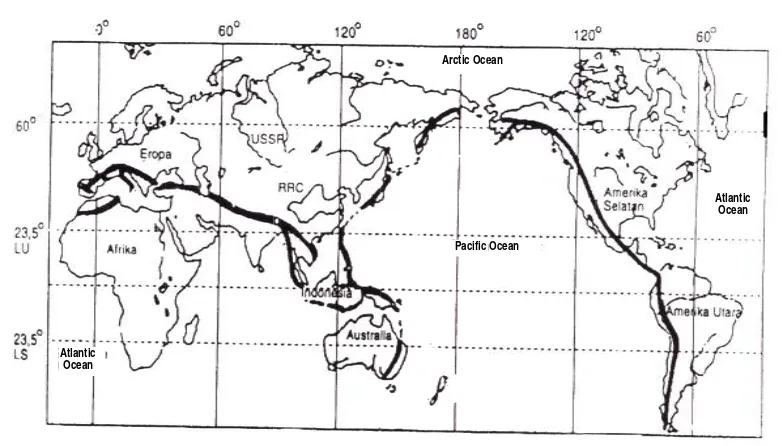
Fig. 1.6. The movement of islands in Indonesia.C. VOLCANISM
The process of releasing magma from inside the earth out into the earth's surface is called volcanism. The magma is generally released to the earth's surface through cracks, faults, and crater.
1. Intrusion and Extrusion of Magma
Inside the earth's crust, exactly under a volcano, there is a big room with irregular walls that is called magma chamber. Magma chamber contains very hot semisolid liquid, which is called magma. If the hot magma comes out and reaches the earth's surface, it is called lava. After some time, the temperature of lava will be colder and finally harden. The hardened or frozen lava is called frozen stone.
The magma which intrudes or moves upwards can reach the earth's surface, but sometimes it can harden and freeze before it reaches the earth's surface. If the moving magma cannot reach the surface, it is called magma intrusion, while if it reaches the surface of the earth, it is called magma extrusion.
2. Shapes of Volcanoes
According to their shape, volcanoes can be classified into three types:
a. Shield volcano, i.e. the volcanoe that is shaped like a shield. This volcanoe has a very flat slope. The material being emitted when there is eruption is very liquid lava. Example: Mount Manoa Loa in Hawaii.
b. Strato volcano, i.e. the volcano that is shaped like a cone. The material being emitted when there is eruption varies between very liquid lava and very thick, semisolid lava. This type of volcano will become higher each time it erupts. Generally, the volcanoes in Indonesia are of strato types.
c. Maar, i.e. the volcane that has high-explosive eruptions. When it erupts, the stones around its crater will be ruined and pushed outward, so that the crater will form a funnel. Example: Mount Paricutin in Meksiko, and Mount Rinjani di Nusatenggara, Indonesia. If the bottom and the wall surrounding the funnel
Social Sciences Chapter 1
6
are impermeable, the crater will form a crater lake, like that of Mount Rinjani and Mount Kelud.
Fig. 1.7 Strato Volcano Fig. 1.8 Maar
3. Materials Being Erupted
When a volcano erupts, it will blow out three types of material, i.e. solid material, liquid material (lava) and gas. The solid material is called piroclasticss, and can be categorized into: (a) big stones, called bombs, (b) small stones, called lapili, (c) pebbles and sand, and (d) dust or volcanic ash.
Gases brought out from volcanoes are called exhalation.Those gases can be in the forms of sulfide acid (H2S), sulfat acid (H2SO4), carbon dioxyde (CO2), chloride
(CL), water (H2O) and sulfida (HCL).
Extraordinary explosion can destroy the peak of a volcano, so that it forms a very large crater with steep walls. The diameter ranges from one to fifty kilometers. Such kind of crater is called kaldera. For example Tengger Caldera (8 km), Ijen Caldera (11 km) , Iyang Caldera (17 km), Tambora Caldera (6 km), Batur Caldera (10 km), and Aso Caldera (in Japan, 25 km wide).
A volcano which is about to explode usually shows the following signs: (1) temperature around the crater rises;
(2) many water resources around the volcano dry out; (3) volcanic earthquakes takes place quite often;
(4) tumultuous sounds comes out of the volcano frequently; (5) many animals come down the slope.
Several animals such as swan, bat, elephants, and tigers, can detect the natural signs whether a volcano is about to erupt.
4. Post Volcanic Symptoms
Social Sciences Chapter 1
7
a. Emitting carbon dioxide and monooxiode (CO2 and CO) gases which are called
mofet. This kind of gas is dangerous and can cause death to the people who breath it in. For example: Timbang and Nila Craters in Dieng (Central Java), Tangkuban Perahu, and Papandayan (West Java).
b. Emitting sulphuric gas, called solfatara. For example: Tangkuban Perahu (West Java), Dieng (Central Java), Rinjani (West Nusa Tenggara) and Minahasa (North Sulawesi).
c. Emitting water vapor, called fumarol. For example: Dieng, and Kamojang (West Java).
d. Source of hot water. The hot water is caused by the ground water which is absorbed down the surface and reaches the place with a high temperature, i.e. the place where there are still remains of magmatic activities. The hot water will comes out as a spring, and if it contains sulphur it can be used as medication for several types of skin diseases.
e. Source of mineral water. This kind of spring contains certain minerals, such as sulphur. Examples of mineral water spring can be found in Ciater and Maribaya (West Java), Lourdes (France) and Minahasa (North Sulawesi).
f. Geyser, i.e. the source of hot water, whose water bursts out of the ground periodically. The famous geyser is in Yellow Stone National Park, California (USA), where the water burst can reach up to 40 meters high. Such water burst can also found in Cisolok, Sukabumi, West Java.
5. Advantages of Volcanoes
a. The volcanic ash emitted by the volcanoes during explosion can fertilize the soils because it contains lots of natural fertilizers.
b. The materials comeing out of the volcanoes are in the forms of sand, pebbles, and big stones. All constitute industrial minerals that can be used as materials for buildings.
c. Volcanoes are formed from the extrusion of magma out of the earth. Magma that comes out brings minerals, metals, and many other mining materials. Therefore, in the mountainous and volcanic area, many valuable minerals and precious stones are found.
d. High volcanoes can bring about the orografic rains, which makes the area fertile and good for agriculture.
6. Disadv a. W liv b. Ex bu c. On the for the d. Th rai flo W e. Hi Th Le f. Th the g. Vo dis bre
7. Lines o Br the wor F
vantages of When eruptin ving things. xploding vo urn out wha n a certain v
e blazing l rming hot v e mudflow he deposits in, can turn owing stone Whatever com
igh volcano he rain shad embah Palu he explosion
e explosion lcanic ash sturb the pl eath.
of Mountain roadly spea rld, i.e. the M
Fig. 1.9 Lin Atlantic
Ocean
Volcanoes ng, the volc
olcanoes can atever it pas
volcano, the lava will co volcanic mu
coming dow of frozen l n into cold es, small ro mes across t oes which s
dow area h , Central Su n of a volca n of Krakata
from erupt lane flying
n and Volca aking, there
Mediteran a
nes of Volcan
anoes put o
n also extin sses through
ere is a crat ome out an udflow. Thi
wn from M lava on top d mudflow.
ock, and wa this cold mu
tand up ne has a relativ ulawesi.
ano can als au in Sunda ting volcan
around the
anoes e are two li
and Circum
noes in Medit
Socia
out blazing
nguish extre h.
ter lake on i nd get mix is mudflow Mount Kelud
p of a volca This cold ater-saturate
udflow can xt to each o vely low ra
so bring ab Strait in 18 no can float e area, ruin
ines of volc m Pacific.
teran and Ci Pacific Arctic Oce
l Sciences
lava which
emely hot g
its top. Wh xed with th w is very dan d (East Java)
ano, when mudflow c ed sand, sli be destroye other can fo ainfall and
out tsunam 883.
t in the air ning the cro
canoes (kno ircum Pacific Ocean ean
Chapter 1
h is very dan
gas (hot clou
en the volc he water in ngerous. Fo ).
poured ou can be in t iding down ed and ruin orm a rain s
is drier. Fo
mi wave. Fo
for severa ops, and aff
own as Ring
c
8
ngerous for
ud) and can
ano erupts, n the lake, or example:
ut by heavy he form of n the slope. ned.
shadow area. or example:
or example:
al days and fect human
g of Fire) in
Social Sciences Chapter 1
9
8. Volcanoes in IndonesiaThe total number of active volcanoes in Indonesia is approximately 119. Since the early Seventeenth Century, 70 of all the volcanoes have frequently exploded.
Fig. 1. 10. Mountainous area in Indonesia
There are two lines of mountains in Indonesia, that is:
a. Sunda Mountain Chain, i.e. the line of mountains rowing from Sumatera Island, to Java, Nusa Tenggara, South Moluccas, and ends up Banda Island.
b. Sahul or Circum Australia Mountain Chain, i.e. the line of mountains rowing from Australia, to the east end of Papua Island, continuing to the middle part of Papua with the highest peak Jayawijaya.
c. Sangihe Mountain Chain, i.e. the line of mountains rowing from Sangihe Islands (North Sulawesi) to Minahasa, Gorontalo Bay (with Mount Una-Una which often erupts) up to South Sulawesi.
d. Halmahera Mountain Chain, i.e. the line of mountains rowing from Talaut Island, Maju and Tifor Islands in North Moluccas, continuing to Halmahera, Ternate and Tidore Islands, and then turning east up to the Bird Head area.
e. Kalimantan Mountain Chain, i.e. the line of mountains rowing from Palawan Island (The Philippines) down to North Kalimantan (Malaysia), still down to Indonesian region in Kalimantan.
D. EARTHQUAKE
Do you still remember that, based on the plate tectonics theory, a load of potential energy will escalate in the thrust area which, if the force is too high, will be able to release itself? Releasing the energy will cause vibration or shake on the earth's plate or crust around it. This kind of shake or vibration on the earth's crust is
a
e
b
c
d
South ChineseSea
Indian Ocean
Celebes Sea
Social Sciences Chapter 1
10
called earthquake or seism. The science that studies about earthquake is called
seismology.
In 2003 there was a large earthquake in Nabire (Papua) and Padang Panjang (Sumatera). In 2006, another devastating earthquake also took place in Yogyakarta. The earthquake caused many vatalities, damaged houses, broken pipes of drinking water, and landslides. Therefore, if an earthquake is taking place, you should get out of your house to an open place (field or yard), get away from buildings to avoid danger. If there is an earthquake and you cannot get out of your room, protect your head with a pillow and move away from glass cupboards or windows, and get down under a table.
1. Types of Earthquakes
Based on what causes them, earthquakes can be distinguished into three types, i.e.: a) Volcanic Earthquakes
Earthquakes that are caused by volcanic eruptions are called volcanic earthquakes. For example: Merapi earthquake (Central Java), Una-Una earthquake (Tomini Bay), and Pericutin earthquake.
b) Tectonic Earthquakes
Tectonic earthquakes are the ones caused by the movement of the earth's crust. This crust movement is caused by the release of potential energy on the thrust area. The 2006 earthquake in Yogyakarta is an example of tectonic earthquake. c) Debris Earthquakes
Debris earthquakes are the earthquakes that are caused by landslide, falling caves, and other similar events. This kind of earthquakes usually only has small impacts.
2. Intensity/Magnitude of an Earthquake
The shakes of an earthquake are rapidly transformed in any directions. The focus of earthquake inside the earth's crust is called hypocentrum. The point on the surface directly above the hypocentrum is called epicentrum. The epicentrum area usually experiences the most damage. The farther an area from the epicentrum the weaker shock it will receive and the less damage it will experience. To measure the magnitude of an earthquake we use a tool named seismometer. Seismometer which can record by itself is called seismograph. The record of a seismograph is called
seismogram.
Social Sciences Chapter 1
11
weak earthquake from a strong one. The measurement of an earthquake is very important to determine the quality of buildings that are resistant to earthquakes.
The seismic waves radiate outwards from the hypocentrum and spread out in any directions in the form of shock waves. The shock waves consist of two types, i.e.: primary wave (P) and secondary wave (S). Besides that, there is another wave creeping through the earth's surface in the form of long wave(L).
To calculate the distance of epicentrum we use Laska Formula, i.e.:
=
{ (S - P) - 1} x 1 megameterWhere
:
=
distance of epicentrum from the earthquake recording station.
S – P
=
time difference between the first and second waves (minutes) 1 megameter = 1.000 km.Example of using LASKA Formula:
The station of Meteorology and Geophysics Agency (BMG, Badan Meteorolgi dan Geofisika,) in Jakarta, on 26 December 2004 recorded an earthquake. The primary wave was recorded at 08.22’ while the secondary wave was at 08.24’.30’’. How far is the distance of the epicentrum from Jakarta?
Jawab: = {(4.24’30’’ – 4.22’) – 1)} x 1 megameter = (2’30’’ - 1) x 1,000 km = 2½ - 1 x 1,000 km = 1,500 km.
So, the distance of epicentrum from Jakarta is 1,500 km.
3. Risky areas for Earthquakes in Indonesia and in the World
Indonesia is one of the countries that most often experiences earthquakes. This is because Indonesia is surrounded by subduction zone (the point where oceanic platec thrust downwards). The places that often experience earthquakes are Jayawijaya mountain, northern beach of Irian, Maluku, Central Sulawesi, and North Sulawesi, Nusatenggara, southern part of Java and western part of Sumatera. Earthquakes are quite often followed by landslides and tsunamis. Therefore, the people who live in the earthquake-risk areas should always be alert, and the houses as well as other buildings should be designed to be resistant to earthquakes. Waves of
tsunami can come inland (up to the beach) until several kilometers away from the beach line.
Other countries in the world that often experience earthquakes are Chinese, Japan, Philipines, Afganistan, Iran, Turkey, United States, and the countries on the west coast of Southern America. In Japan, school children are often trained how to face the danger of earthquakes and tsunamis.
E. T
con fold
the clas classroo earthqu
TECTONI
The pla ntinental pla d (forming c
W upward w downward area is call
If fault, whe or move si
H
while slen
located b track of f Slenk Sem Toba, Lak
sses to the om has an uake).
ISM
ate that is ate. The cra curves) or e
We can see will become
d will be va led anticline
f the compr re the crust ideways.
Horst (the cr
nk or graben
between lin fault runnin mangko. Al ke Kerinci, Vertical fol Isocline fold
school fiel emergency
moving le ash and com even break.
Fig. 1. 11 T
this pheno e lines of alleys betwe
e, while the ressional fo t fractures. P
rust that is
n (the crust nes of moun ng across fr
long the Sle and Lake R
ding
ing
ld as soon y exit door
eft or right mpressiona
Types of fold
omenon in o mountains een the mou
downfold a orce to the
Parts of the
s shifted up that is shif ntains or hi rom the nor enk Semang Ranau.
Down fo b. Oblique fol napp
Socia
as possible that can be
will finall al force can
ding (Katili)
our neighb or hills, w untains or h area is calle crust conti
fracture ca
pward) wil fted downw ills (Fig. 1.1 rth end to th
gko there a olding
lding became a pe fault
l Sciences
e. (Note: It e used anyt
ly crash ov cause the e
orhood. Th while the c hills. In a fo
d syncline. inues, the f an be shifted
ll be seen l ward) will b 12). In Sum he south en are several b Down folding mo became a nappe
Hang
Chapter 1
will be bet time when
ver and com earth's crus
he crust tha crust that w olded crust,
folding can d upward, d
like block be seen like
atera Island nd of the isl
big lakes su oved and
fault ging folding
12
tter if each there is an
mpress the st bend and
at is folded was folded , the upfold
n become a downward,
E. C
f
CHANGIN The m endogeneti
force. The e
creatures. sedimentat 1. Weathe W parts or all part dead tr wet rai turned weathe tree bec process beings is called
Fig. 1.13 P its outer w
mechan
NG RELIEF mountains, ic force, afte
exogenetic fo
In fact, th tion.
ering Weathering
r decay into ts of the m ree, for exam
in in the r to small p ering is calle
cause the e s is called ch
or other liv d biological w
Pyramid in E wall experien ical weather
g
OF THE EA hills, and o er tens or h
orce can be he exogenet
is the proc o more stab material are mple, is exp rainy weath pieces and ed mechanic
end part of
hemical weat
ving creatur
weathering o
Egypt, nces ing F ( a graben, the valley part o
Fig. 1.12 T
ARTH'S SU other relief hundreds of sunlight, ra tic force in
ess that ma le substanc
rotten. Do posed to hot her. Eventu decompos
cal weatherin
the roots e
thering. Som res (ant, wo or organic w
Fig 1.14 Stala (chemical we and undergro
of a fault
Socia
Types of Faul
URFACE of the earth years will ain, wind, f n nature c
akes earth m e. If a mater you know
t sunlight e ually, the tr
sed into si
ng. A hard s expels a cer metimes ston orm, lichen, eathering. agtit eathering) ound river horst, the up
l Sciences
lts (Katili).
h's surface w be broken o flowing wat auses wea materials br rial decays, what caus everyday, co
ree will be mpler subs stone can b rtain chemi nes are brok , mold). Suc
Fig the wit plift of a fault
Chapter 1
which were or ruined by
ter, glacier, thering, er
reakdown in , it means th ses the wea
old wind at e decayed a
stances. Th e broken by ical substan ken because ch kind of w
1.15 Stone w temple are c th lichen (bio weatherin
13
e formed by y exogenetic
and living rosion, and
Social Sciences Chapter 1
14
2. ErosionThe decayed stones will gradually be scraped off and transformed into another place by the exogenetic force. The exogenetic force that can scrape off and move the decayed stones consists of water, wind, and glacier. The process of scraping and transporting materials as a result of weathering is called erosion.
a. Water Erosion
Types of erosion by water are:
1) splash erosion, erosion caused by raindrops. Raindrops can break soil granules. 2) sheet erosion, erosion of ground surface layer by the flowing water on the
surface.
3) gully erosion, scraping the earth layer until it forms a channel with < 40 cm wide and < 25 cm deep.
4) ditch erosion, scraping the earth layer until it forms a channel with > 40 cm wide and > 25 cm deep.
5) slope erosion, eroding the river bank by the flowing water of the river. 6) abrasion, abrading the beach by sea waves.
b. Wind Erosion
This kind of erosion takes place in the dry area and desert. The process of grinding stones by wind is called deflation. The fast-flowing wind in the desert can fly away dust and lift up sand grains. If the grains bump into the lower part (foot) of a big stone it can scrape the stone in such a way that it forms a mushroom stone (Fig. 1.16). This process of erosion by wind is called corrasion.
Fig. 1.16 Mushroom stone in Fig. 1.17 Mesa and butte Atacama (Chili) in Arizona (USA)
c. Glacial Erosion (exarasion).
Social Sciences Chapter 1
15
Fig. 1.14 Iceberg in the ocean Fig. 1.15 Tracks of glacier erosion3. Sedimentation
Sedimentation is the process of depositing materials as a result of erosion by water, wind, tidal waves, and glacier. Materials resulted from the erosion will be brought by the flowing water (or wind, waves, or glacier) and will be deposited in the lower area.
a. Sedimentation by water
Mud and other materials resulted from the erosion brought by the flowing water will be put down or deposited in the lower area. The place where the materials are deposited might be: lowland, reservoir, dam, lake, estuary, beach, and the bottom of the sea. The lake, reservoir, dam, and swamp will be shallowed and finally extinct if the sedimentation of mud resulted from the erosion continuous for a long time. What should we do to keep the reservoir and lake can be maintained?
What will happen if the mud or material resulted from erosion is deposited on estuaries or on the beach? The mud sedimentation will form delta and sandbar.
Delta is a land on the estuary which is formed by river sedimentation, while sandbar is a pile or deposit of sand on the beach which stands out of the sea water when the tide subsides and get underwater again when tide rises.
Fig. 1.16. Delta in an estuary
The ground water in beach-ridge is generally plain water, even though the other ground water around it is salty. Therefore, beach-ridge is often used by sailors to fulfil their needs on plain water on the beach.
Social Sciences Chapter 1
16
a. Sedimentation by windMaterials resulted from erosion carried out by wind will be deposited in several forms (appearance), i.e.:
a. Loess. Dust carried out by wind from the desert will be accumulated around the desert and form loess. Loess is very fertile and good for agriculture, if there is enough water.
b. Sand dunes, i.e. sand deposits on the beach resulted by wind sedimentation.
c. Barchan, i.e. sand deposits by wind forming shapes like horse shoes. Barchan is typically found in desert and beach. In Indonesia, barchan can be found in Parangtritis beach, Yogyakarta.
b. Sedimentation by glacier
When glacier moves downward it will scrape off the soil or rock below that is goes through. The material resulted from this scrape will be accumulated and deposited at the end of the glacier. The sediment may form moraine or drumlin.
F. TYPES OF ROCKS
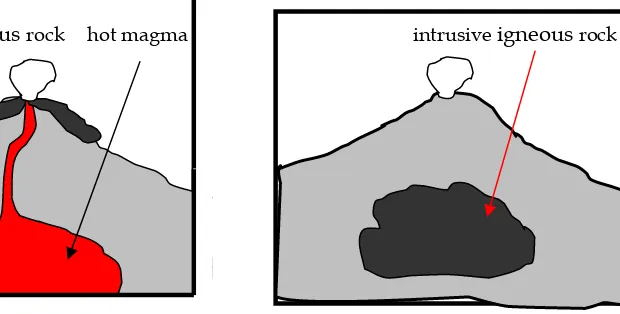
On the earth's surface there are three types of rocks, i.e. igneous rock, sedimentary rock, and metamorphic rock. Igneous rock originated from the cooling and solidification of magma or lava. Based on the location where it got cooled, igneous rock can be distinguished into three types, i.e.: extrusive igneous rock, hypabyssal frozen rock, and intrusive igneous rock.
1. Igneous rock
extrusive
igneous rock hot magma intrusive igneous rockFig. 1.17 Barchan in Parangtritis
Fig. 1.18 Extrusive igneousrock
Hyp
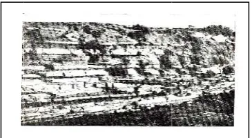
2. Sedi
scrap carri lakes sedim type is tha Fig. a
pabissal igne
imentary r
In the rain ped by win
ed out, accu s, swamps,
mentation. O of rock is c at it consists
1.19 Hypabi
Fig. 1. 22 S
a
Fig 1.23 a. Br
eous rock Roc
rock
ny season, t d, water, an umulated, and lowla Over time, th
called sedim
s of layers. issal igneou
Sedimentary
reccia b. Con
k layers
the frozen r nd other ex and deposi ands. The p
he sedimen
entary rock. us rock
y rock b nglomerate
Socia
rock that ha xogenetic fo ited on the process of d ntation will
The main c Fig. 1.21
Specifi sedime nature,
conglom
rock c sharp-p conglom which Inside someti animal turned
fossil. T being f shells o
l Sciences
as experienc orce. The scr
lower grou depositing be solid an characteristi Taj Mahal, m
c and u entary rock
, such
merate. Brec
composed pointed
merate is is compose
the s mes there ls or plan d into ston The remains
fossilized ar of sea anima
Chapter 1
ced weather raped mate und such as the materia nd turn into
ic of sedime made from m
unique ty k are often
as brecc ccia is sedi
of fragmen ends, sedimenta ed of dull fra
sedimentary e are rem ts that ha ne, which
s of living c re, for exam
als, shrimps
17
ring will be erial will be s the ocean, al is called o rock. This entary rock marbles
ypes of found in
cia and
Social Sciences Chapter 1
18
Based on the agent carrying materials that form the deposit, sediment can be categorized into three types, i.e.:
a. Aeolic or aeric sediment, i.e. sedimentary rock formed by wind. b. Aquatic sediment, i.e. sedimentary rock formed by water. c. Glacial sediment, i.e. sedimentary rock formed by glacier.
3. Metamorphic rock
Both the frozen rock and sedimentary rock can turn into metamorphic rock if it obtains excessive pressure, high temperature, and for a long time (millions of years). The term metamorphic comes from the words meta = other and morph = form. So, metamorphic rock is the type of rock that has changed its form, because of obtaining excessive pressure and high temperature for a long time. For example, limestone, after getting excessive pressure and high temperature for a long time, turns to be marble.
Do the exercise in small groups
Fill in the following tablesNo N
Name of Rock Nama batuan
Type of rock (select one)
Frozen Sedimentary Metamorphic
Social Sciences Chapter 1
19
G. RELIEF OF EARTH'S SURFACE
Relief of the earth's surface can be distinguished into two groups, i.e. land relief and ocean relief.
1. Land Relief
In general, the land relief can be classified as follows:
a. Volcanoes, mountain and hills.
The earth's surface has some parts that convex (bend upwards) and some others concave (bend downwards). The appearance of such a surface is called the
earth's relief. The surface that bends upwards can be the volcanoes, mountains, and hills. Volcanoes are the place where magma may expels out from the inner part of the earth. This kind of volcano is called active volcano and can explode anytime. The volcano that has no record of eruption is called extinctvolcano.
Fig. 1.24 Active Volcano. Fig. 1.25 Mountains
b. High land and low land
An area that is relatively flat with the height less than 200 meters above sea level is called low land. Low land is mostly found in coastal area. If the relatively flat area is found in higher position, it is called high land or plateau. For example: Gayo high land (Nanggroe Aceh Darussalam), Bandung high land (West Java), and Dekan high land (India). The high land area is generally a fertile agricultural region which functions as potential producer for agriculture. In Indonesia, high lands and mountains constitute potential producers for vegetables and fruit.
Social Sciences Chapter 1
20
c. BeachThe land that is located on the seaside is called beach. Part of the beach which lies between surface levels of high tide and low tide is called the seaside area. In the coastal area, the possible relief is as follows:
1) Cape, i.e. the land that extends out to the sea. A very long cape is called
peninsula.
2) Gulf, i.e. the sea that extends out to the land.
3) Delta, i.e. sedimented soil in the estuary. The eroded soil from mountain was carried out by the river water, and then it is deposited in the estuary. Similarly, soil or sand deposited on the beach which is drowned during high tide and appears out during low tide is called sandbar.
Fig. 1.28 Bay Fig.1. 29 Cape
1. Make a sketch about the relief of earth's surface around your neighborhood.
Write down the names of hills, mountains, or rivers in the picture.
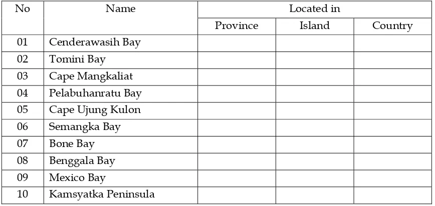
2. Take your atlas and do the following task in groups
No Name Located in
Province Island Country
01 Cenderawasih Bay
02 Tomini Bay
03 Cape Mangkaliat 04 Pelabuhanratu Bay 05 Cape Ujung Kulon
06 Semangka Bay
07 Bone Bay
08 Benggala Bay
09 Mexico Bay
Social Sciences Chapter 1
21
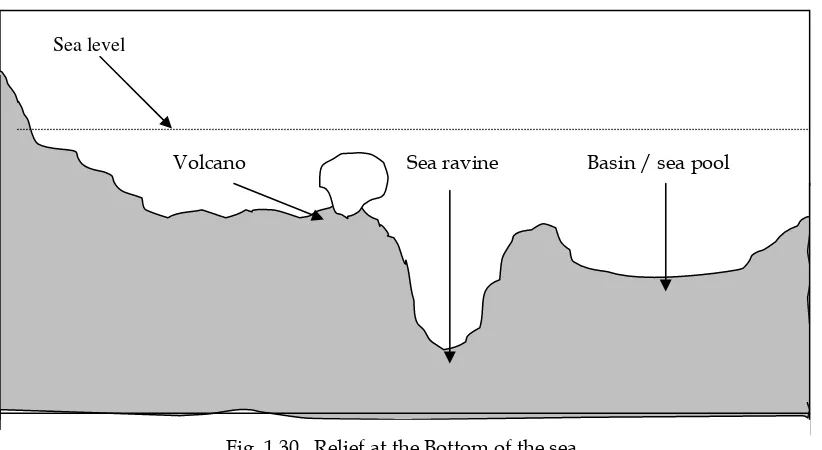
2. Ocean ReliefThe relief of the bottom of the sea is not flat as well. It is similar to the land relief, with some parts bend upwards (convex) and some other curve downwards (concave), as seen in the following picture.
Sea level
Volcano
Sea ravine
Basin / sea poolFig. 1.30 Relief at the Bottom of the sea
The forms of earth's surface on the sea bottom can be distinguished as follows: a. Sea ravine, i.e. the ocean valley with deep and steep sides.
b. Basin or sea pool, i.e. the sea bottom that is similar to the sea ravine, but the bottom is wider and more flat..
c. Rift valley, i.e. a curve like a wide and long trench on the sea bottom
d. Under water Mountain, i.e. series of mountains that is located under the sea level. e. Oceanic volcano, i.e. the volcano located on the sea bottom and under the sea
level.
The relief of earth's surface is formed as a result of endogenetic and exogenetic forces. The endogenetic force is volcanism, seism and tectonism. The endogenetic force functions as the former of earth's surface relief. The exogenetic force is sunlight, temperature, water, wind, glacier, and living creatures. The exogenetic force is destructive to the relief that has been formed by the endogenetic force.
Social Sciences Chapter 1
22
After learning this chapter, you should understand about:
1. The endogenetic natural process that causes the earth's relief. 2. Indonesia's position in the risky area of earthquakes and volcanoes. 3. Things to do when there is an earthquake.
4. Differences between folding and fault.
5. Weathering process, erosion and sedimentation. 6. Forms of relief on earth's surface in land and in ocean.
7. The positive and negative impact from endogenetic and exogenetic forces and the efforts to overcome it.
1. On 5 July 2004 the BMG Cirebon station recorded an earthquake occurred. The primary wave (P) was recorded at 04.20’ and the secondary wave (S) was recorded at 04.25’30”. The distance of epicentrum from the BMG Cirebon station was …
a. 6,000 km c. 4,500 km.
b. 5,500 km. d. 5,300 km.
2. In the convection area, the newly formed relief will be … a. Ocean volcano, sea ravine, and basin.
b. Ocean ridge, ocean volcano, and ocean rift. c. Underwater island, sea ravine, and ocean ridge. d. Andesit mountain, sea ravine, and ocean valley.
3. Relief that is formed in the subduction zone is ... a. Sea ravine and basin.
b. Sea ravine and chain of mountain. c. Ocean volcano and ocean rift. d. Ocean valley and ocean ridge.
4. The phenomenon of magma intrusion from magma chamber towards the earth surface is called …
a. Tectonism. b. Seisme. c. Diatropism. d. Volcanism.
5. Limestone cave, stalagtit and stalagmit are formed from the …. weathering. a. mechanical c. chemical
Social Sciences Chapter 1
23
B. Complete the Concept Map below:Relief of Earth's Surface
is formed by
Endogenetic force Exogenetic force
in the form of
Volcanism Seism Tectonism
which is which is which is
The relief formed: The relief formed: The relief formed:
1. ………. 1. …………. 1. ………..
2. ………. 2. ………… 2. ………..