THE SPATIAL DEVELOPMENT OF HERITAGE CITIES
OF HINDU KINGDOM IN BALI
Case: Karangasem City
I Gusti Ngurah Wiras Hardy1, Bakti Setiawan2, Budi Prayitno3
1
Karangasem City is one of the heritage cities of Hindu Kingdom in Bali that has established its sovereignty ever since the seventeenth century. From the very beginning, Karangasem City played a significant role as the central government of Karangasem Kingdom. The spatial development of Karangasem City is remarkable; so that the spatial development process needs to be observed in order to get various factors that influence it. This research applied qualitative method covering field observations, interviews, and literature studies. Field observations were conducted to empirically explore the condition of Karangasem City, whereas the interviews and literature studies were conducted to explore the history and condition of Karangasem City. Based on the exploration results, the spatial development process of City-Kingdom of Karangasem is caused by two main factors, namely: (1) the residential development of upper community (puri, jero, and geria); and (2) the residential development of lower community (umah-banjar pakraman and rumah-kampung). It implies that the development of residential and the existence of community groups have become the determinants of spatial development of Karangasem City, ever since the initial formation until the present day.
Keywords: spatial development of the city; Karangasem City; residential; community groups
ABSTRAK
Kota Karangasem merupakan salah satu kota peninggalan Kerajaan Hindu di Bali yang berdiri secara berdaulat sejak abad XVII. Pada masa awal berdirinya, Kota Karangasem berperan penting sebagai pusat pemerintahan Kerajaan Karangasem. Perkembangan spasial Kota Karangasem menarik untuk diidentifikasi untuk memperoleh pemahaman mengenai proses perkembangan spasial kota dan pelbagai faktor yang mempengaruhinya. Penelitian ini menerapkan metode penelitian kualitatif dengan observasi lapangan, wawancara, dan studi literatur. Observasi lapangan dilakukan untuk menelusuri secara empiris mengenai kondisi Kota Karangasem, sedangkan wawancara dan studi literatur dilakukan untuk menelusuri sejarah dan kondisi Kota Karangasem. Berdasarkan hasil penelusuran, proses perkembangan spasial Kota Kerajaan Karangasem disebabkan oleh dua faktor utama, yaitu: (1) perkembangan hunian kelompok masyarakat atas (puri, jero, dan geria); dan (2) perkembangan hunian kelompok masyarakat bawah (umah-banjar pakraman dan rumah-kampung). Hal ini menunjukan bahwa perkembangan hunian dan keberadaan kelompok masyarakat, menjadi faktor penentu perkembangan spasial Kota Karangasem sejak awal terbentuknya hingga sekarang.
Kata kunci: perkembangan spasial kota; Kota Karangasem; hunian; kelompok masyarakat
1.
INTRODUCTION
In this era, city has been the important part of human life and civilization. A city can be considered as life entity, which is continuously developing as the place for human beings to perform various activities and to satisfy various human needs. Therefore, each city in the wold experiences various development caused by various factors derived from inside or outside the city, particularly those derived from environmental condition and society (Sujarto, 1970: 1; Nelissen, 1974: 94 in Nas, 1979: 57).
In the initial era of the kingdom, Karangasem Kingdom established Karangasem City with its components, which had main function as capital city and the central government of Karangasem Kingdom. In its development, Karangasem City experienced various dynamics, derived from inside and outside Karangasem City. Until now, various developments still can be identified by exploring the heritage of Karangasem Kingdom which still survives and is utilized until now. Therefore, Karangasem City is interesting for more comprehensive investigation, so that the description regarding spatial development of Karangasem City and the influential factors can be obtained.
The result of this investigation is expected to be able to be used as the input for government and policy makers, in determining the direction of spatial development of Karangasem City which is more comprehensive and useful, for the citizens of Karangasem City in the future. Moreover, the result of this research is expected to be able to be used as the foundation and approach for the researchers or academicians, who attempt to explore the spatial development of other cities in Bali or similar cities. Therefore, the result of this research can be used extensively to formulate the direction of spatial development of Karangasem City and other cities in Bali.
2.
LITERATURE REVIEWS
a.
Concept of City
City is the place of complex human life and becomes inseparable part of human life development history. The understanding about city involves a complex scope and canbe understood from various scholarly perspective. According to Nas and Boender (2002: 206), a city can be considered as a social phenomenon related to various kinds of aspect, such as: politics, social, culture, and economy.
A city can be seen as the central terriroty, for it has a significant function and is strategical to serve the surrounding areas or hinterland. According to Christaller (in Nas, 1979: 29), a city is the center of service, particularly for the surrounding areas. In supporting the function, a city has various complete facilities compared to the surrounding areas. This, a city has an appeal and becomes the center of activity and residences for people (Mumford, 1956 in Gallion dan Eisner, 1986; Harris and Ullman, in Nas, 1979: 30).
In more extensive explanation, Kostof (1991: 37-40) stated that a city is a place for people and buildings in performing various activities regulated according to regulation and certain order. Even so, a city cannot independently stand but it has relationship which city and the surrounding areas need each other, especially in case of the need for primary supply for people. Therefore, a city can be considered as the center of human life, buildings, and the center for the surrounding areas.
A city is the center of complex human life, so that it needs various aspects to understand, such as: morphological aspect, functional, administrative, population, social and economical (Sujarto, 1970; Hoekveld, 1973, in Nas, 1979: 32). According to morphological aspect, a city is one of modal points which is as a place for people and various facilities needed by human beings. According to functional aspect, a city is considered as focal point which constitutes the center of various people’ activities. In relation to population aspect, Hansen (2006: 147) stated that a city is at least occupied by thousands of people. Meanwhile, according to social and economical aspects, a city is occupied by heterogeous people with very complex needs.
Residence is the primary part of a city and can be considered as the city itself. In relation to it, Doxiadis (1968; 1977: 52) called residences occupied by human as human settlements, which is an area as the place for human staying to assure their living. Human settlement defined in the description does not only cover micro scale, but also cover macro scale, so that the city can be seen as human settlements. In understanding and studying the human settlements, Doxiadis (1968; 1977) mentioned five elements of human settlement developer, which are: nature, anthropos/man, society, shells, and networks.
In Indonesia, a city is initially understood as a fort, an area protected and maintained, important position, the central government, or the center of kingdom (Mulyandari, 2011: 24). Thus, the cities in Indonesia have important role as central government and community economic activity. According to Nas and Boender (2002: 207), old cities in Indonesia can be classified into two types: (1) remote city is cities centered in remote area with the economic activity based on agriculture; and (2) coastal city is cities centered in coastal area with the economic activity is based on trade.
is generally occupied by kingdom as the king residence, surrounded by religious leaders, temporal leader, servants, soldiers, and craftsmen so that a concentric circle will be established.
Based on the description, it can be understood that a city is the center of life, activity, area, and residence for human beings. Thus, a city has been the part of and appeal for people to enhance life degree and as the place to satisfy the human needs. Therefore, a city can be consicered as the reflection of human civilization storing various values, which are continuously developing in accordance with the purpose and the need of its society.
b. City Development Process
City development process is a complex process and takes place in relatively long period. Generally, the process of city development is initiated by the changing process of rural area into urban area, as a result of structural change in society (Mumford, 1956 in Gallion and Eisner, 1986; Nas, 1979: 42). The structural changes are: life needs change, livelihood change, and people life style change. The structural development taking place in the society also affects the city development to be more complex. This makes a pierce difference between rural and urban areas.
Rural and urban areas basically can be distinguished based the area orientation. According to Mumford (in Nas, 1979: 28), a village can be seen as interal-oriented place, homogenous, and the citizens mostly work in agricultural field. Meanwhile, a city is considered as external-oriented place, heterogenous, and the people mostly work in the field of service and trade. Thus, village plays role as the supply of food, whereas a city plays role as the center for services for society.
The process of city development generally takes place almost in all cities existing in the world, consistent with the development of people life. According to Sujarto (1970: 2), the process of city development in the world has started since antiquity, although the population is not as many as now. In Romanian era, the cities developed with high cultural level according to the improvement of culture and people standard of living, but the cities have not been connected intensively with other citites surrounding.
In middle ages, domination of nobility causes cities surrounded by forts as the defense. In the era of industrial revolution, the cities in various countries experienced physical and functional development (Sujarto, 1970). The city development physically will give more opportunities for society to perform increasingly varied activities. Meanwhile, the diversity of people activity, will encourage physical development of city to be more complex.
In relation to it, Sujarto (1970: 1) explained that there were several factors affecting city development, namely: (a) the growth of human awareness as social beings; (b) the availability of various opportunities; (c) food material surplus; and (d) transportation development. Meanwhile, according to Nelissen (1974: 94 in Nas, 1979: 57), the factors influencing city development process, such as: (1) ecology comprising: land condition, climate, and natural resources; (2) technology, comprising: transportation, and information; and (3) social organization.
Based on those different explanations, it can be understood that a city developes in relatively long period, starting from an area with limited citizens, developing to a more complex area as a result of internal and external influences. Physical and functional development taking place in a city will give specific characteristics to a city. According to Sujarto (1970: 1), a city which has specific characteristics will be able to reflect the level of civilian and the natures of people occupying. Therefore, different values, ideas, and goals hold by urban people, and different needs and activities performed by urban citizens, are able to determine and direct the development of a particular city.
3.
METHOD
4.
DISCUSSION
a.
Brief History of Karangasem Kingdom
Spatial development of Karangasem City is closely related to the history of Bali and the history of Karangasem City. The history of Karangasem Kingdom, was initiated by the fall of Gelgel Kingdom as a result of various rebellions taking place in Gelgel Kingdom. In 1556 A.D. occurred a great rebellion in Gelgel Kingdom, performed by Patih Agung Batanjeruk (I Gusti Arya Batanjeruk) together with I Dewa Anggunan. The success of Gelgel soldiers to solve the rebellion, forcing Patih Agung Batanjeruk to escape to Bungaya Village in Karangasem area, but he was finally killed by the soldiers of Gelgem Kingdom in 1556 (Putra Agung, 2009: 43). At the time, the wife and foster child of Patih Agung Batanjeruk named I Gusti Oka (Oka Prince), succeeded to escape and flee to Budakeling, Karangasem.
At the particular time, there were two notable events as the beginning of Karangasem ruler, namely: (1) the wedding ceremony between I Dewa Karang Amla with the widow of Patih Agung Batan Jeruk; and (2) the appointment of I Gusti Oka as Karangasem ruler replacing I Dewa Karang Amla, pursuant to the agreement between I Dewa Karang Amla with the widow of Patih Agung Batan Jeruk (Putra Agung, 2009: 44-45). This was characterized the establishment of Karangasem Kingdom and the reign of Batan Jeruk Dinasty in Karangasem area. Since then, ruler replacement had occurred several times with various notable events marking them.
In the middle of XVII century, I Gusti Anglurah Ktut Karang as the King of Karangasem III, establishing Puri Amlaraja or Puri Kelodan, as the residence of the King of Karangasem and his family and the central government of Karangasem Kingdom at the time. The next period, Karangasem Kingdom was ruled by the King of Karangasem IV or the King of Tri Tunggal, consisting of three kings, namely: I Gusti Wayan Karangasem, I Gusti Anglurah Nengah Karangasem, and I Gusti Anglurah Ktut Karangasem. According to Putra Agung (2009: 45-46), at the time Karangasem Kingdom developed into a big kingdom which had territory in Bali and Lombok Island.
In the rule of the King of Karangasem VII, Karangasem Kingdom had ruled the most of Bali and Lombok Islands, covering Buleleng, Jembrana, and almost all areas of Lombok. Even so, it could not survive any longer for after the leaving of the King of Karangasem VII, Karangasem Kingdom started to experiencing deterioration as a result of intervention from Colonial government of Netherland. In 1849, the Government of Netherlands had ruled Karangasem Kingdom and performed modernization in various fields (Putra Agung, 2009: 176).
The transition from colonial era to independence until now, characterized the end of kingdom ruling era in the territory of Indonesia, including Karangasem. Even so, various heredity of the history of Karangasem Kingdom still could be identified until now. This was separable from the attempt of society and government, in maintaining various heredity of the kingdom which was full with historical and cultural values.
3.4 The Citizens of Karangasem City
The citizens of Karangasem City could be divided into several social groups, based on the livelihood, descent, people’ origin, and social activity. According to Putra Agung (2009: 14-17), the citizens of Karangasem could be classified into catur warna based on the type of livelihood, and catur wangsa/jatma based on the descent. Catur warna and catur wangsa, could be divided into four groups, namely: (1) brahmana was religious leaders and intellectuals; (2) ksatrya was the leaders in the field of government and military; (3) wesya was the nobles, merchants, or traders; and (4) sudra was the workers, farmers, or labors. In Bali, the first three groups (brahmana, ksatrya and wesya) were known as triwangsa, whereas sudra group was known as jaba.
Karangasem citizens were relatively heterogenous citizens, for they did not only come from Bali Island. According to Putra Agung (2009: 107), based on the origin, Karangasem citizens could be divided into two primary groups, namely: (1) kawula or kaula was the native citizens of Karangasem; and (2) wong dura-desa was citizens coming from outside Bali Island or foreigners from abroad. Citizens from the outside Bali Island were still dominated by the citizens of Sasak Muslim coming from Lombok Island, whereas the foreigners, among them came from: China (Tiongkok), Malay, Java, Arab and Europe.
The citizens of Karangasem, particularly the kaulas, generally stayed in bigger traditional social groups and managed various activities in the field of social, culture and religion. The groups were: desa pakraman (Balinese traditional village) and banjar pakraman (Balinese traditional hamlet). Desa Pakraman was a relatively big social group and consisted of several banjar pakraman. According to Geertz and Geertz (1975: 14), the existence of desa pakraman was characterized with the existence of Pura Kahyangan Tiga as the place of worship, consisting of: (1) Pura Puseh as the place of worship of Ida Sang Hyang Widi/The God Almighty in the manifestation as Brahma or the Creator; (2) Pura desa or Pura Bale Agung as the place of worship of Ida Sang Hyang Widi/The God Almighty in the manifestation as Vishnu or The Preserver/The Corrector; and (3) Pura Dalem as the place of worship of Ida Sang Hyang Widi/The God Almighty in the manifestation as Shiva or the Destroyer/Pemralina. Meanwhile, the existence of banjar pakraman was characterized by bale banjar or community hall around the residence (Geertz and Geertz, 1975: 17).
Various explanations showed that the social groups in Karangasem City had various purposes and benefits. The groups established people awareness toward various rights and responsibilities as the part fo Karangasem City citizens, which also influenced the progress and sustainability of Karangasem City. By that awareness, the rulers and citizens of Karangasem, believed that harmonious, peaceful and prosperous life would be achieved. In its development, the existence of social groups also influenced the direction of spatial development of Karangasem City since the initial era of establishment until now.
3.5 Territory of Karangasem and Karangasem City
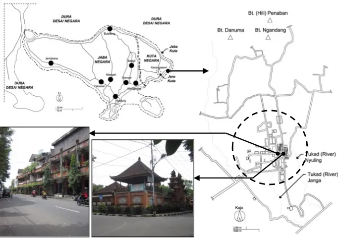
Administratively, Karangasem is located in the eastern edge of Bali Island. The borders of Karangasem territory consist of: (1) the north, has border with Bali Sea; (2) the east, has border with Lombok Strait; (3) the south, has border with Indonesia Ocean; and (4) the west, has border with Buleleng, Bangli, and Klungkung Regencies (BPS of Karangasem Regency, 2013: 3). Meanwhile, Karangasem City is the capital of Karangasem Regency located in the southeast edge of Karangasem Regency. In this era, Karangasem City is more known as Amlapura City, which is customarily a part of Pakraman Village territory of Karangasem (fig. 1).
Geographically, the territory of Karangasem is surrounded by tukad or river, namely: Tukad Janga, Tukad Nyuling, and Tukad Pati, whereas the hilly area extending in the side of kaja (north), comprising: Danuma Hill, Ngandang Hill, and Penaban Hill. This natural condition makes the territory of Karangasem City relatively rich, so that many citizens utilizing it as agricultural land and plantation. Meanwhile, the outer territory of Karangasem City is rural areas, settlements or agricultural land located in outside geographical borders.
If it is explored historically, the division system of Karangasem territory becomes the areas inside and outside the city, has been known since the era of kingdom or around XVII-XIX century. In the era, the King of Karangasem mentioned the territory of Karangasem or the territory of Karangasem Kingdom as kuta negara (Putra Agung, 2009: 102). According to Putra Agung (2009: 102), based on its hierarchy and function, the territory of kuta negara can be divided into two primary areas: (1) jero kuta; and (2) jaba kuta. Jero kuta is understood as the territory in Karangasem City serving as the capital and the central government, whereas jaba kuta is understood as the outer territory of Karangasem City which is still the part of Karangasem area. The territory of jero kuta and jaba kuta is bordered by landscape and settlements serving as the place to stay and the kingdom defense.
78
Based on the historical exploration, people condition, and the condition of Karangasem City, can be idenfied two phenomena influencing the spatial development of Karangasem City from the era of kingdom up to now, which are: (1) spatial development of the city as a result of residence development of upper-class communities or triwangsa; and (2) spatial development of the city as a result of residence development of lower-class communities, comprising kaula/jaba and wong dura desa. The residence development of upper-class communities in relation to the development of puri, jero, and geria as the residence of brahmana, ksatrya, and wesya or triwangsa group. Meanwhile, the residence development of lower-class communities in relation to the development of banjar-banjar pakraman as the residences of kaula or jaba group, and villages as the residences of wong dura desa, particularly Muslim Sasak people.
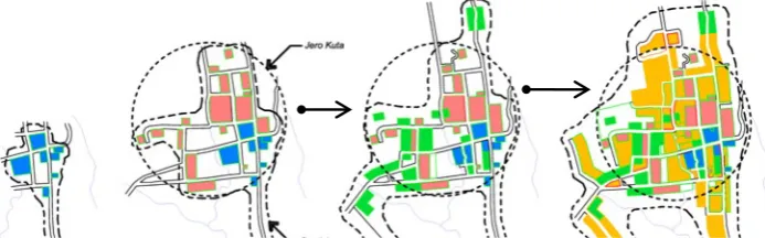
The process of spatial development of Karangasem City as a result of residence development of upper-class community, can be divided into four periods namely: (1) initial era of kingdom; (2) the heyday of kingdom; (3) colonial era; and (4) independence era until now (fig. 3). The initial era of kingdom was started in XVII century, marked by the establishment of Karangasem Kingdom sovereignly. In the middle of XVII century, the King of Karangasem III established Puri Amlaraja or now is called as Puri Kelodan, which is the first puri of Karangasem Kingdom, as the residence of the king and central government of Karangasem Kingdom.
Puri Kelodan was established in the north side of Puri Batuaya or Sriwedari, which was the residence of the ruler of Karangasem prior to Karangasem Kingdom establishment sovereignly. Thus, Puri Kelodan remains considered as the first puri marking the establishment of Karangasem Kingdom sovereignly. The existence of Puri Kelodan also marked the initial era of Karangasem City which played important role as capital city, the central government, the center of economy, social, and culture in Karangasem territory (fig. 2).
Around eary of XVII century, Karangasem Kingdom reached the heyday peak and became one of big kingdoms in Bali and Lombok Islands. In this era, the King of Karangasem established Puri Kaleran or now is called as Puri Gede/Ageng Karangasem, in the north side of Puri Kelodan. The establishment of Puri Gede Karangasem was accompanied with the movement of king residence and the central government of Puri Kelodan to Puri Gede Karangasem, whereas Puri Kelodan served as kepatihan. In XIX century, the King of Karangasem re-established several puri around Puri Gede Karangasem, namely: Puri Ageng Kanginan which is currently called as Puri Kanginan, and Puri Kaleran serving as the king of residence and king family.
Figure. 2. The scheme of puri development and the transfer of central power and government in Karangasem Kingdom City
Source: Hardy, et. al., 2015
Other residences located around the puri are geria which is the residence of brahmana or Hindu hermit. Based on its hierarchy, geria is a residence whose value is madya under puri, for it has more simple room functions. In the era of the kingdom, several gerias which can still be identified until now, namely: Geria Pendem, Geria Karang Sidemen, Geria Cawu, Geria Pidada, Geria Punia, Geria Tegeh, Geria Gerembeng, and Geria Sindhu.
After the fall of Karangasem Kingdom in the middle of XIX century, the condition of Karangasem City did not experience significant change. At that time, Dutch Colonial Government established several modern buildings to support various activities of government in Karangasem City, such as: landschap office, controller office, arsenal, hospitals and schools. One significant development taking place in Karangasem City was the establishment of new palebahan (yard) in the north side of Puri Kanginan or Puri Agung Karangasem, as the residence of stadehouder (the representative of Dutch government) and new central government.
Figure. 3. The process of spatial development of Karangasem City as a result of the development of upper-class community residence (puri, jero, and geria)
Source: Hardy, et. al., 2015
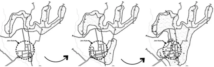
In other exploration, it can be seen that the development of desa pakraman, banjar pakraman, and kampung (village) as the residence of lower-class communities, also influenced the spatial development of Karangasem City from the initial era of establishment until now. In this case, desa pakraman dan banjar pakraman in Karangasem is a Balinese traditional community established by the native people of Karangasem or the kaulas, to manage different heterogenous activities, social and cultural activities. Meanwhile, kampung (village) in Karangasem is a traditional community established the new comers or wong dura desa, which generally come from Lombok (fig. 4).
Based on the exploration of the history of Karangasem, the process of spatial development of Karangasem City as a result of the development of lower-class communities, can be divided into three periods, which are: (1) the initial era of kingdom establishment; (2) the era of incoming Muslim Sasak; and (3) the era of independence until now (fig. 5). The early establishment of kingdom, it was marked by the establishment of Desa Pakraman Karangasem and banjar-banjar pakraman murwa consisting of eleven banjar pakraman, as the founder of Desa Pakraman Karangasem. This event was estimated taking place in the era of the King of Karangasem IV or King Tri Tunggal.
Figure. 4. The scheme of development of custom banjar/pakraman and villages in Karangasem Kingdom City
Source: Hardy, et. al., 2015
In 1691 to 1740, Karangasem started to extend the territory to Lombok Island (Putra Agung, 2009: 55). In the government of the King of Karangasem IV, Karangasem Kingdom had succeeded to be able to rule the most of Lombok Island. This was marked by the establishment of Karangasem Kingdom-Sasak as the representative of Karangasem Kingdom in Lombok Island. In that era, Muslim Sasak citizens started to come to Karangasem City as tetadtadan or the followers of the King of Karangasem. In its development, the King of Karangasem gave several lands to Muslim Sasak citizens to stay until Muslim Sasak villages (kampung) around Karangasem City were built.
Based on its location, these villages were spread in the territory of Karangasem City, presicely in the territory of border between jero kuta and jaba kuta. This aims at establishing natural fort for kingdom and is based on the consideration of agricultural lands and plantation location. The existence of Muslim villages in the territory of Karangasem City can be accepted well by the society, due to the mutual assistance and tolerance beyween both communities. This was markerd by what so called nyama Sasak for Muslim Sasak citizens stayed in Karangasem. In this case, nyama means relatives or part of family.
Figure. 5. The process of spatial development of Karangasem City as a result of the development of lower-class community residences (desa pakraman, banjar pakraman, and villages/kampung)
Source: Hardy, et. al, 2015
Based on the various explanations, it can be understood that the development of desa pakraman, banjar pakraman, and village (kampung) becomes one factor determining the spatial development of Karangasem City. The process of development can be observed from the early of Desa Pakraman Karangasem and eleven banjar pakraman murwa establishment centered on the side of Karangasem City. After Muslims of Lombok entering, Muslim villages start to establish on the side of Karangasem City as the fort of kingdom defense. In the era of independe until now, the rapid growth encouraged the establishment of banjar-banjar pakraman asesabu in the territory of Karangasem City. This development showed the form of harmonious and tolerant life, between people living in Karangasem City.
4
CONCLUSION
The process of spatial development of Karangasem Kingdom City has started since the establishment of Karangasem Kingdom until now. Based on the result of historic exploration and physical condition of Karangasem City, the spatial development of the city is caused by two primary factors, namely: (1) spatial development of Karangasem City as a result of residences of upper-class community consisting of: puri, jero, and geria; and (2) spatial development of Karangasem City as a result of the development of lower-class communities, consisting: desa pakraman, umar-banjar pakraman and rumah-kampung (Muslim village). The development process as a result of the first factor can be divided into four periods, whereas the development processes as a result of the second factor can be divided into three periods. Therefore, it can be understood that the development of residences and the existence of communities can be one primary influential factor and determines the direction of spatial development of Karangasem City. Therefore, the existence of communities can be used as the foundation and approach to explore the spatial development of similar cities in Bali. Thus, the result of approach later on can be utilized extensively as the input in formulating policies and the direction of spatial development of cities in Bali.
ACKNOWLEDGEMENT
In this part, the author is grateful for Ida Sang Hyang Widi Wasa/The God Almighty for all blessings. Thanks to Mr. Prof. Dr. Anak Agung Gede Putra Agung, S.U. and Mr. Gede Wijaya Kusuma for all information which has been given during the research process. Thanks to family and all parties which have given motivation. Hope this writing can be useful for all readers and society.
REFERENCES
1) BPS of Karangasem Regency. (2013). Karangasem in Figures 2013. Karangasem: Badan Pusat Statistik Kabupaten Karangasem, Bali
2) Doxiadis, C. A. (1968). Ekistics: an Introduction to the Science of Human Settlements. London: Hutchinson and Co. Ltd.
3) Doxiadis, C. A. (1977). Ecology and Ekistics (Westview Environmental Studies: Volume 6). Colorado: Westview Press, Boulder
4) Gallion, A. B. and Eisner, S. (1986). The Urban Pattern: City Planning and Design (fifth edition). New York: Van Nostrand Reinhold Co. Inc.
5) Geertz, C. (1980). Negara, The Theatre State in Nineteenth-Century Bali. Princeton University Press
6) Geertz, H. and Geertz, C. (1975). Kinship in Bali. The University of Chicago Press
8) Hardy, I G. N. W., Setiawan, B., and Prayitno, B. (2015). Tata Spasial Kota Kerajaan Karangasem (unpublished research report). Universitas Gadjah Mada, Yogyakarta
9) Kostof, S. (1991). The City Shaped: Urban Patterns and Meanings Through History. London: Thames and Hudson Ltd.
10) Mulyandari, H. (2011). Pengantar Arsitektur Kota. Yogyakarta: Penerbit C.V. Andi Offset
11) Munandar, A. A. (2005). Istana Dewa Pulau Dewata: Makna Puri Bali Abad ke 14-19. Depok: Komunitas Bambu
12) Nas, P. J. M. (1979). Kota di Dunia Ketiga: Pengantar Sosiologi Kota (jilid 1). Jakarta: Bhratara Karya Aksara
13) Nas, P. J. M. and Boender, W. (2002). Kota Indonesia Dalam Teori Perkotaan, in Nas, P. J. M. (2007). Kota-kota Indonesia: Bunga Rampai. Yogyakarta: Gadjah Mada University Press
14) Parimartha, I G., et. al. (2013). Sejarah Bali Pertengahan Abad XIV-XVIII, in Ardika, I W., dkk. (2013). Sejarah Bali, Dari Prasejarah Hingga Modern. Denpasar: Udayana University Press
15) Putra Agung, A. A. G. (2009). Peralihan Sistem Birokrasi dari Tradisional ke Kolonial. Yogyakarta: Pustaka Pelajar