Open Geospatial Consortium
Submission Date: 2016-04-04
Approval Date: 2016-09-23
Publication Date: 2017-02-23
External identifier for OGC® document: http://www.opengis.net/doc/BP/CDB-core-annexes/1.0
Internal reference number of this OGC® document: 16-005r2
Version: 1.0
Category: OGC® Best Practice
Editor: Carl Reed
Volume 2: OGC CDB Core: Model and Physical
Structure: Informative Annexes
Copyright notice
Copyright © 2017 Open Geospatial Consortium
To obtain additional rights of use, visit http://www.opengeospatial.org/legal/.
Warning
This document defines an OGC Best Practices on a particular technology or approach related to an OGC standard. This document is not an OGC Standard and may not be referred to as an OGC Standard. It is subject to change without notice. However, this document is an official position of the OGC membership on this particular technology topic.
Document type: OGC® Best Practice Document subtype: Volume 2
2
License Agreement
Permission is hereby granted by the Open Geospatial Consortium, ("Licensor"), free of charge and subject to the terms set forth below, to any person obtaining a copy of this Intellectual Property and any associated documentation, to deal in the Intellectual Property without restriction (except as set forth below), including without limitation the rights to implement, use, copy, modify, merge, publish, distribute, and/or sublicense copies of the Intellectual Property, and to permit persons to whom the Intellectual Property is furnished to do so, provided that all copyright notices on the intellectual property are retained intact and that each person to whom the Intellectual Property is furnished agrees to the terms of this Agreement.
If you modify the Intellectual Property, all copies of the modified Intellectual Property must include, in addition to the above copyright notice, a notice that the Intellectual Property includes modifications that have not been approved or adopted by LICENSOR. THIS LICENSE IS A COPYRIGHT LICENSE ONLY, AND DOES NOT CONVEY ANY RIGHTS UNDER ANY PATENTS THAT MAY BE IN FORCE ANYWHERE IN THE WORLD.
THE INTELLECTUAL PROPERTY IS PROVIDED "AS IS", WITHOUT WARRANTY OF ANY KIND, EXPRESS OR IMPLIED, INCLUDING BUT NOT LIMITED TO THE WARRANTIES OF MERCHANTABILITY, FITNESS FOR A PARTICULAR PURPOSE, AND NONINFRINGEMENT OF THIRD PARTY RIGHTS. THE COPYRIGHT HOLDER OR HOLDERS INCLUDED IN THIS NOTICE DO NOT WARRANT THAT THE FUNCTIONS CONTAINED IN THE INTELLECTUAL PROPERTY WILL MEET YOUR REQUIREMENTS OR THAT THE OPERATION OF THE INTELLECTUAL PROPERTY WILL BE
UNINTERRUPTED OR ERROR FREE. ANY USE OF THE INTELLECTUAL PROPERTY SHALL BE MADE ENTIRELY AT THE USER’S OWN RISK. IN NO EVENT SHALL THE COPYRIGHT HOLDER OR ANY CONTRIBUTOR OF
Contents
1. Scope ... 5
2. Conformance ... 7
3. References ... 7
4. Terms and Definitions ... 7
5. Conventions ... 7
5.1 Identifiers ... 8
6. Annex A: Conformance Class Abstract Test Suite (Normative) ... 9
7. Annex B Rationale: Sensor Simulation - Achieving Device-Independence ... 10
8. Annex C: Reasons for Using Jpeg ... 12
9. Annex F Rationale: Partitioning the Earth into Tiles ... 14
10. Annex G Rationale: Importance of Level of Detail ... 18
11. Annex H Informative: JPEG ... 20
12. Annex I Informative: ZipFile Format Notes ... 22
13. Annex J: Light Names and Hierarchy ... 24
14. Annex M: CDB Directory Naming and Structure ... 36
15. Annex O: List of Texture Component Selectors ... 37
16. Annex Q: Table of Dataset Codes ... 45
17. Annex R: Derived Datasets within the CDB ... 48
4 i.
Abstract
This document provides the Annexes for the CDB Core: Model and Physical Structure standard. The only exception is Annex A, Abstract Test Suite. The CDB ATS Annex is in Volume 1: Core document.
ii.
Keywords
The following are keywords to be used by search engines and document catalogues. ogcdoc, OGC document, CDB, annexes
iii.
Preface
Attention is drawn to the possibility that some of the elements of this document may be the subject of patent rights. The Open Geospatial Consortium shall not be held
responsible for identifying any or all such patent rights.
Recipients of this document are requested to submit, with their comments, notification of any relevant patent claims or other intellectual property rights of which they may be aware that might be infringed by any implementation of the standard set forth in this document, and to provide supporting documentation.
iv.
Submitting organizations
The following organizations submitted this Document to the Open Geospatial Consortium (OGC):
CAE Inc.
Carl Reed, OGC Individual Member Envitia, Ltd
Glen Johnson, OGC Individual Member KaDSci, LLC
The OGC CDB standard is based on and derived from an industry developed and
maintained specification, which has been approved and published as OGC Document 15-003: OGC Common DataBase Volume 1 Main Body. An extensive listing of
contributors to the legacy industry-led CDB specification is at Chapter 11, pp 475-476 in that OGC Best Practices Document
(https://portal.opengeospatial.org/files/?artifact_id=61935) .
v.
Submitters
All questions regarding this submission should be directed to the editor or the submitters:
Name Affiliation
Carl Reed Carl Reed & Associates David Graham CAE Inc.
1.
Scope
This document contains a number of annexes related to the OGC CDB Core standard. For the purposes of being able to cross reference this OGC Best Practice with the previous versions of the CDB standard, the following annex “crosswalk” is provided.
OGC Best Practice and CDB 3.2 OGC CDB Standard Version 1.0 Formerly Annex A10 in Volume 2 Annex B Rationale: Sensor Simulation -
Achieving Device-Independence
Main Body: Rationale for using JPEG Annex C Reasons for Using JPEG
6
Formerly Annex D in Volume 2 Annex E: ShapeFile dBASE III Guidance Formerly Annex A.11 in Volume 2 Annex F: Annex F Rationale: Partitioning the
Earth into Tiles
Formerly Annex A.12 Annex G Rationale: Importance of Level of Detail
Formerly Annex A.17 Volume 2 Annex H: JPEG Informative annex
Was Annex U, Volume 2 Annex I ZIP File Informative annex
Formerly Annex E, Volume 2 Annex J: Light Hierarchy
Formerly Annex M, Volume 2 Annex M: CDB Directory Naming and Structure Formerly Annex O, Volume 2 Annex O: List of Texture Component Selectors Formerly Annex Q, Volume 2 Annex Q: Table of Dataset Codes
Formerly Annex R, Volume 2 Annex R: Derived Datasets within the CDB Formerly Annex S, Volume 2 Annex S: Default Read and Write values to be
used by Simulator Client-Devices
For ease of editing and review, the standard has been separated into 12 Volumes and a schema repository.
● Volume 0: OGC CDB Companion Primer for the CDB standard. (Best Practice)
● Volume 1: OGC CDB Core Standard: Model and Physical Data Store Structure. The main body (core) of the CBD standard (Normative).
• Volume 2: OGC CDB Core Model and Physical Structure Annexes (Best Practice).
● Volume 3: OGC CDB Terms and Definitions (Normative).
● Volume 4: OGC CDB Use of Shapefiles for Vector Data Storage (Best Practice).
● Volume 5: OGC CDB Radar Cross Section (RCS) Models (Best Practice).
● Volume 7: OGC CDB Data Model Guidance (Best Practice).
● Volume 8: OGC CDB Spatial Reference System Guidance (Best Practice).
● Volume 9: OGC CDB Schema Package: provides the normative schemas for key features types required in the synthetic modelling environment. Essentially, these schemas are designed to enable semantic interoperability within the simulation context. (Normative)
● Volume 10: OGC CDB Implementation Guidance (Best Practice).
● Volume 11: OGC CDB Core Standard Conceptual Model (Normative)
● Volume 12: OGC CDB Navaids Attribution and Navaids Attribution Enumeration Values (Best Practice)
2.
Conformance
This section is not applicable to this document.
3.
References
The following normative documents contain provisions that, through reference in this text, constitute provisions of this document. For dated references, subsequent
amendments to, or revisions of, any of these publications do not apply. For undated references, the latest edition of the normative document referred to applies.
4.
Terms and Definitions
This document uses the terms defined in Sub-clause 5.3 of [OGC 06-121r8], which is based on the ISO/IEC Directives, Part 2, Rules for the structure and drafting of
International Standards. In particular, the word “shall” (not “must”) is the verb form used to indicate a requirement to be strictly followed to conform to this Best Practice.
Other Terms and Definitions may be found in Volume 3: OGC CDB Terms and Definitions (normative) of Best Practice.
5.
Conventions
8
5.1 Identifiers
The normative provisions in this Best Practice are denoted by the URI http://www.opengis.net/spec/CDB/1.0/annexes
6.
Annex A: Conformance Class Abstract Test Suite (Normative)
10
7.
Annex B Rationale: Sensor Simulation - Achieving
Device-Independence
Formerly Annex A10 in Volume 2
One of the primary objectives of the CDB Standard is to provide and integrate all of the data required by all sensor devices, not just Image Generators producing the Out the Window (OTW) scenes. The purpose of this integration, among other things, is to achieve and maintain a high level of correlation among the many client-devices (subsystems) within a simulator. Furthermore, this integration must be done independently of the client-device or the sensor type, with little or no duplication of data amongst clients. In addition to the OTW, many simulator client-devices are required to simulate the synthetic environment over different portions of the electromagnetic spectrum, infrared (e.g. FLIR, NVG), microwaves (e.g. radar), audio (e.g. sonar), etc. Up to now, the current state of the art approaches to the simulation of sensors has typically been quite proprietary to the client-device implementation of the various vendors. There have been no universally accepted simulation models suitable for use in simulation. Sensor simulation typically requires a simulation of the device itself, supplemented by a complete simulation of the synthetic environment over the portion of the electromagnetic spectrum that is relevant to this device. The former simulation is referred to as the
Sensor Simulation Model (SSM) while the latter is called the Sensor Environmental
Model (SEM). In the past, the SEM relied heavily on environmental databases whose content was designed to match the functionality, fidelity, structure and format requirements of the SEM. The level of realism possible by the SEM depended heavily
on the quality, quantity and completeness of the data available. The environmental database was highly device-specific and could not be readily ported to other platforms. A SEM is usually based on mathematical model of the environment for the portion of the electromagnetic spectrum of interest. The SEM acts much as a black box that produces a response in accordance to input data. A significant portion of this data must come from the CDB; however, the key is to segregate all device-dependent data and all SEM-dependent data from the modeling data that represents the synthetic environment. In order to accommodate the most different kind of sensors possible, a common denominator must be chosen. In the CDB standard, this common denominator is called a material. This is the subject of this annex.
a) the sensor types to be supported.
b) the vendors’ sensor simulation implementations to be supported.
c) the level of fidelity, functionality and precision of the SEMs to be supported.
Clearly, the task of determining a definitive list of material properties that would accommodate all of the above requirements for the today’s sensor types, vendor implementations and SEMs would be a significant challenge. Furthermore, once released, the materials properties would limit any SEM innovation by the industry. As a result, the CDB Standard limits its jurisdiction over the material properties.
Instead, the CDB standard defines and publicly defines a list of materials that can be used in a CDB. It is the responsibility of each vendor to define the properties (that satisfies the sensor type) for these CDB materials. As a result, vendors are totally free to select material properties that satisfy the fidelity, functionality and precision requirements of the SEM for the sensor type of interest. Alternately, if the vendors have their own list of materials, they can create a mapping between CDB materials and their internally supported list of materials. This approach allows client-devices to retain their SEMs as well as their own sets of material properties.
12
8.
Annex C: Reasons for Using Jpeg
(Formerly from body of Best Practice Volume 1)
The CDB Standard prescribes the use of an industry standard compression algorithm for its storage intensive raster imagery datasets. This not only provides a substantial
reduction in storage, but also reduces the data transmission bandwidths associated with simulator’s access to the synthetic environment database at runtime. As a result of its storage efficiency, the CDB Standard relies on relatively few data formats for storing its datasets. There is no benefit (other than storage efficiency) to be gained in supporting any other specialized data formats whose underlying objective is only for storage efficiency. The CDB Standard embodies the JPEG 2000 industry standard format for raster imagery because it has comparable storage efficiency to all of these image formats without
sacrificing any generality. JPEG 2000 has been chosen by the CDB Standard as a format for the storage of OTW raster imagery because of the following characteristics:
1. High compression efficiency: Compression better than 0.25 bits per pixels. Virtually indiscernible loss in image quality for 10:1 – 20:1 compression.
2. Lossless and lossy compression: Lossless compression ratios approx. 1.7:1 3. Perceptual color space internal coding: Allow dark images to be reconstructed without banding artifacts.
4. High dynamic range: Compress and decompress images with various dynamic ranges (e.g., 1-bit to 16-bit) for each color component.
5. Large images sizes: Up to (2^32 - 1)
There are other characteristics of the JPEG 2000 that are worth mentioning but are not directly beneficial to the CDB Specification. Those are:
1. Progressive image reconstruction: Allow images to be reconstructed with increasing pixel accuracy and resolution.
3. Seamless quality and resolution scalability: Without having to download the entire file
4. Error resilience during transfers.
14
9.
Annex F Rationale: Partitioning the Earth into Tiles
Formerly Appendix A11 in Volume 2 of the CDB Best Practice.
This section provides rationale for partitioning the world into tiles.
The design of the CDB standard tile representation is centered on three primary considerations:
(1) A tile representation comprehensive enough to accommodate the entire earth.
(2) A tile representation that lends itself to real-time implementation by a CDB system and all of its attached simulator client-devices.
A numerically straightforward mapping (such as a simple scaling) to map lat-long coordinates into CDB coordinates and vice versa is highly desirable for real-time implementation considerations.
(3) A tile representation with a system of units that conforms as much as possible to geographic standards.
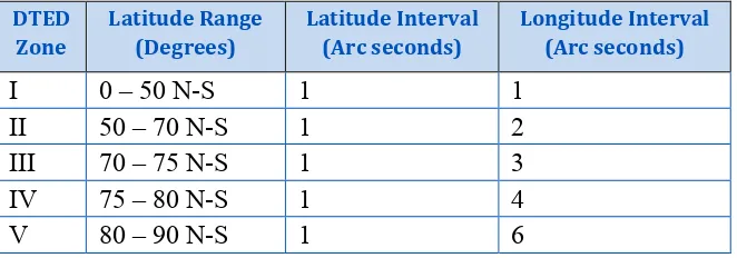
Table A-3. INTERVALS FOR DTED LEVEL 2 the guiding principles that constrain the approach used by the CDB tile representation:
(1) The earth model is divided (in latitude) into slices. (2) The slice’s x-axis is aligned to WGS-84 lines of latitude. (3) The slice’s y-axis is aligned to WGS-84 lines of longitude.
(4) The number of units along the slice’s y-axis for a given level of detail is the same for all slices.
The earth surface geodetic dimension in arc-second of y-axis units within an earth slice and in all earth slices is exactly the same, regardless of latitude.
(5) The geodetic dimension of an x-axis unit in arc-second is constant within a zone, but is re-defined at pre-selected latitudes to achieve a greater level of spatial sampling uniformity in all tiles; this overcomes the narrowing effect of increased latitudes on longitudinal distances. The definition of zones in the CDB is the same as those in DTED (with the exception of the poles).
(6) The number of units along the slice’s x-axis for a given level of detail is the same within each zone.
(7) The number of units along the slice’s y-axis is constrained to a 2n-multiple in all slices.
16
arrays; each array represents the same content but at successively finer levels of resolution.
(8) The number of units along the slice’s x-axis will vary depending on which zone the latitude of the slice belongs. At this point we introduce the concept of a CDB Geocell, which differs slightly from a DTED Geocell. A DTED cell is always 1 × 1 degrees. In contrast, a CDBGeocell always has a height of 1 degree but has a varying width depending on its latitude. Table A-4. Size of CDB Geocell per zone shows the dimensions of a CDB Geocell per zones of latitude. For instance, in latitude zone 5, which goes from –50 to 50 degrees latitude, a CDB Geocell is 1 × 1 degree, in zone 4 and 6 which goes from latitude 50 to 70 degrees the cell size is 1 × 2 degrees. The main reason to introduce this concept is to maintain a reasonable eccentricity between the sides by trying to keep them as close to a square as possible. Two criteria are used to define the size of a CDB Geocell:
(a) A CDB Geocell must contain a whole number of DTED Geocells; in other words a CDB Geocell must start and end on a whole degree along the longitudinal axis. This is done so as to facilitate mapping from CDB Geocells to DTED Geocells.
(b) The length of the CDB Geocell must be a whole factor of 180, in other words length of 1, 2, 3, 4, 6 and 12 degrees are legal but lengths of 7 and 8 degrees would not be since these are not exact factors of 180.
Table A-4. Size of CDB Geocell per zone
9 +80 ≤ lat < +89 1 x 6 6
10 +89 ≤ lat < +90 1 x 12 12
The variable CDB Geocell size in the CDB standard has the following benefits:
1. Reduces the simulator client processing overheads associated with the switching from one zone to another. (Due to the small number of zones across the earth.) 2. Reduces the variation of longitudinal dimensions (in meters) to a maximum of
50%.
18
10.
Annex G Rationale: Importance of Level of Detail
Formerly Appendix A-12 of Volume 2 of the OGC CDB Best Practice.
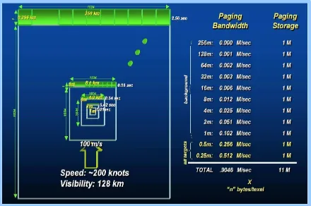
The availability of LODs for most datasets is critical for real-time performance. Many simulator client-devices can readily take advantage of an LOD structure because many clients naturally require less detail with increasing distance away from the simulated own ship position. For example, the projection of screen pixels (i.e. pixels in an IG image plane) onto near-field terrain subtends much less area than the projection of screen pixel onto far-field terrain near the horizon; as a result, much less detail is required at far range. In addition, clients may need to revert to an alternate coarser representation if they cannot cope with the paging bandwidths, memory footprint or computational requirements of finer LODs. This provides a solid basis on which client-devices can build paging managers, load management and memory management algorithms.
The following example illustrates the important performance considerations and the inherent performance advantage that can be achieved with an LOD structure. Consider a simulator client-device, with a capability to display terrain imagery out to 128 km; the imagery is 1m at its finest available resolution and the simulated ownship is flying at 100 m/s. Under these conditions, and without the benefit of an LOD organization (as illustrated in Figure A-15: Paging of Terrain Imagery without an LOD Structure), the client-device would require access to the imagery at a rate of ~100 Mpixels/sec. Consider on the other hand the same operating conditions but with the client-device accessing LOD-organized imagery (as illustrated in Figure A-14: Paging of Terrain Imagery with an LOD Structure). Furthermore, assume that the client-device only requires 1m imagery for ranges less than 1/2 km, 2m for ranges less than 1km, 4m for ranges less than 2km, and so on. With the benefit of an LOD structure, the client-device would require access to the imagery at a much lower rate of ~1 Mpixels/sec, reducing access bandwidth by a factor of ~100x over the non-LOD approach. Clearly, such performance gains cannot be ignored for real-time applications such as flight simulators, especially when one realizes that access bandwidth increases as the square of the imagery resolution.
LOD process; these guidelines are provided with each of the raster-organized dataset (or list-organized datasets in future releases of the CDB standard).
20
Figure A-15: Paging of Terrain Imagery without an LOD Structure
11.
Annex H Informative: JPEG
Formerly Appendix A.17 in Volume 2 of the OGC CDB Best Practice
The CDB standard supports JPEG2000 for both VSTI and VSTLM component data. As a result of the high rates of compression there are no real advantages to be gained in supporting a broad range of alternate color representations (such as single channel representations, indexed color representations, RGB-triplet color encoding such as 5-6-5, etc.). The underlying motivation behind all such schemes is driven by a desire to reduce storage and transmission bandwidths. JPEG-2000 achieves these goals and many others, refer to Table A-8 JPEG 2000 Features.
High compression efficiency:
Compression better than 0.25 bits per pixels, 20% compression efficiency improvement over
JPEG.
High dynamic range: Compress images with various dynamic ranges (e.g. 1-16 bit) for each
color component.
Lossless and lossy compression:
Lossless compression ratios approx. 1.7:1.
Seamless quality / resolution scalability:
Without having to download the entire file.
Progressive image reconstruction:
Allows images to be reconstructed with increasing pixel accuracy and resolution.
Large images sizes - up to (232 - 1).
Perceptual color space internal coding. Single decompression architecture. Region of interest coding:
Permits certain ROI’s in the image to be coded and transmitted with better quality and less distortion than the rest of the image.
22
12.
Annex I Informative: ZipFile Format Notes
Formerly Annex U in Volume 2 of the OGC CDB Best Practice
The archive zip format used in the CDB standard is based on APPNOTE.TXT - .ZIP File Format Specification
URL: http://www.pkware.com/documents/APPNOTE/APPNOTE-6.3.1.TXT
Version: 6.3.1
Revised: April 11, 2007
Copyright (c) 1989 - 2007 PKWARE Inc., All Rights Reserved.
The use of certain technological aspects disclosed in the currentAPPNOTE is available pursuant to the below section entitled "Incorporating PKWARE Proprietary Technology into Your Product".
CDB zip compliant reader is required to support as a minimum the following features defined in APPNOTE.TXT:
• Local file header (Note: Extra field can be inserted but not required to be read)
• File data
• Data descriptor:
• Central directory structure (Note: Digital signature is supported but will not be read)
• End of central directory record: (Note: ZIP file comments are supported but will not be read)
The compression methods supported:
• No compression
• Deflate (Enhanced Deflate is not required to be supported)
The following features are not required to be supported thus are optional and left to the implementation
• Archive decryption header:
• Archive extra data record.
• Zip64 end of central directory record
• Zip64 end of central directory locator
• Encryptions of any type
24
36
14.
Annex M: CDB Directory Naming and Structure
Formerly Appendix M, Volume 2 of the OGC CDB Best Practice
In previous versions of the CDB specification, Appendix M was used to present the complete list of names allowed to construct the directories of the CDB. As of version 3.2, the appendix has been replaced by a combination of folder hierarchy and metadata files delivered with the CDB Distribution Package.
The /CDB folder hierarchy provides a complete list of directory and file name patterns of the CDB; it summarizes the structure of the CDB presented in chapter 3, Volume 1: Core. The following files are necessary to expand the patterns:
• /CDB/Metadata/Feature_Data_Dictionary.xml provides the list of directory names associated with feature codes.
• /CDB/Metadata/Moving_Model_Codes.xml provides the list of names for DIS Entity Kinds, Domains, and Categories.
• /CDB/Metadata/DIS_Country_Codes.xml contains the list of DIS Country Names.
15.
Annex O: List of Texture Component Selectors
Formerly Appendix O, Volume 2 of the OGC CDB Best Practice
38
006 – Airline Paint Scheme
001 AAH Aloha Airlines Inc. 002 AAL American Airlines Inc. 003 AAR Asiana Airlines Inc. 004 AAW Afriqiyah Airways
005 ABR Air Contractors (UK) Limited 006 ACA Air Canada
007 ACI Air Caledonie International
008 ADR Adria Airways - The Airline of Slovenia 009 AEA Air Europa Lineas Aereas, S.A.
010 AEE Aegean Airlines S.A. 011 AEW Aerosvit Airlines 012 AFG Ariana Afghan Airlines 013 AFL Aeroflot Russian Airlines 014 AFR Air France
015 AGN Air Gabon
016 AHY Azerbaijan Hava Yollary 017 AIC Air-India Limited
018 AIZ Arkia - Israeli Airlines Ltd 019 AJM Air Jamaica
020 ALK SriLankan Airlines Limited 021 AMC Air Malta p.l.c.
022 AML Air Malawi Limited
023 AMU Air Macau Company Limited 024 AMX Aeromexico
025 ANA All Nippon Airways Co. Ltd. 026 ANG Air Niugini Pty Limited 027 ANS Air Nostrum L.A.M.S.A. 028 ANZ Air New Zealand Limited 029 ARG Aerolineas Argentinas 030 ASA Alaska Airlines Inc. 031 ATC Air Tanzania Company Ltd. 032 AUA Austrian Airlines, Osterreichische 033 AUI Ukraine International Airlines 034 AUT Cielos del Sur S.A.
035 AVA Aerovias del Continente Americano – Avianca 036 AVN Air Vanuatu (Operations) Limited
Texture Kind CS1 (Sxxx)
Texture Index CS2 (Txxx)
Description
042 BBC Biman Bangladesh Airlines 043 BCS European Air Transport 044 BCY Cityjet
045 BEE Jersey European Airways Limited 046 BER Air Berlin GmbH & Co. Luftverkehrs KG 047 BKP Bangkok Airways Co. Ltd.
048 BLF Blue1 Oy
049 BLV Bellview Airlines Ltd. 050 BMA British Midland Airways Ltd. 051 BOT Air Botswana Corporation 052 BPA Blue Panorama Airlines S.p.A. 053 BRA SAS Braathens AS
054 BRU Belavia 055 BRZ Samara Airlines
056 BWA BWIA West Indies Airways Limited 057 CAL China Airlines
058 CAW Comair Ltd. 059 CCA Air China Limited 060 CDG Shandong Airlines 061 CES China Eastern Airlines
062 CHH Hainan Airlines Company Limited 063 CLH Lufthansa CityLine GmbH
064 CLX Cargolux Airlines International S.A. 065 CMI Continental Micronesia, Inc.
066 CMP Compania Panamena de Aviacion, S.A. 067 CNW China Northwest Airlines
068 COA Continental Airlines, Inc. 069 CPA Cathay Pacific Airways Ltd.
070 CPN Caspian Airlines Service Company Ltd.
071 CRL CORSAIR
072 CSA Czech Airlines a.s., CSA 073 CSN China Southern Airlines 074 CTN Croatia Airlines
075 CUB Cubana de Aviacion S.A. 076 CXA Xiamen Airlines
077 CYH China Yunnan Airlines 078 CYP Cyprus Airways Limited 079 DAH Air Algerie
40
091 ELY El Al Israel Airlines Ltd. 092 ETD Etihad Airways
093 ETH Ethiopian Airlines Enterprise 094 EVA EVA Airways Corporation 095 EWG Eurowings AG 101 GEC Lufthansa Cargo AG 102 GFA Gulf Air Company G.S.C. 103 GHA Ghana Airways Corp. 104 GIA Garuda Indonesia 105 HCY Helios Airways
106 HDA Hong Kong Dragon Airlines Limited 107 HEJ Hellas Jet S.A.
108 HHN Hahn Air Lines
109 HLF Hapag Lloyd Fluggesellschaft
110 HZL Hazelton Airlines dba Regional Express 111 IAC Indian Airlines
112 IAW Iraqi Airways 113 IBB Binter Canarias
114 IBE Iberia - Lineas Aereas de Espana 115 ICE Icelandair
116 ICL C.A.L. Cargo Airlines Ltd. 117 IRA Iran Air
118 IRC Iran Aseman Airlines 119 IRM Mahan Airlines
120 ISR Israir Airlines and Tourism Ltd. 121 ISS Meridiana S.p.A.
122 IYE Yemenia - Yemen Airways 123 JAI Jet Airways (India) Limited
124 JAL Japan Airlines International Co., Ltd. 125 JAT Jat Airways
126 JAZ JALways Co. Ltd. 127 JKK Spanair S.A. 128 KAC Kuwait Airways
129 KAL Korean Air Lines Co. Ltd. 130 KHA Kitty Hawk Aircargo, Inc. 131 KLM KLM Royal Dutch Airlines 132 KOR Air Koryo
Texture Kind CS1 (Sxxx)
Texture Index CS2 (Txxx)
Description
136 LAM LAM - Linhas Aereas de Mocambique 137 LAN Lan Airlines S.A.
138 LAP TAM - Transportes Aereos del 139 LBC Albanian Airlines MAK S.H.P.K. 140 LBH Laker Airways (Bahamas) Limited 141 LCO Lan Chile Cargo S.A.
142 LDA Lauda Air Luftfahrt AG 143 LDI Lauda Air S.p.A. 144 LGL Luxair
145 LIL Lithuanian Airlines
146 LLB Lloyd Aereo Boliviano S.A. (LAB) 147 LOT LOT - Polish Airlines
148 LPE Lan Peru S.A.
149 LRC Lineas Aereas Costarricenses S.A. 150 LTU LTU International Airways 151 LXR Air Luxor, S.A.
152 MAH Malev Hungarian Airlines Limited 153 MAK Macedonian Airlines
154 MAS Malaysia Airline System Berhad 155 MAU Air Mauritius
156 MAZ Zambian Airways 157 MDG Air Madagascar
158 MEA Middle East Airlines AirLiban 159 MGL MIAT - Mongolian Airlines 160 MGX Montenegro Airlines 161 MLD Air Moldova
162 MPX Aeromexpress S.A. de C.V. 163 MRS Air Marshall Islands, Inc. 164 MSR Egyptair
165 MXA Compania Mexicana de Aviacion 166 NBK Albarka Air Services Ltd. 167 NCA Nippon Cargo Airlines 168 NMB Air Namibia
169 NTW Nationwide Airlines (Pty) Ltd. 170 NWA Northwest Airlines, Inc. 171 OAL Olympic Airlines
172 OAS Oman Aviation Services Co. (SAOG) 173 PAL Philippine Airlines, Inc.
174 PAO Polynesian Limited
175 PGA Portugalia - Companhia Portuguesa de 176 PIA Pakistan International Airlines
177 PLK Pulkovo Aviation Enterprise 178 PNW Palestinian Airlines
42
183 RBA Royal Brunei Airlines Sdn. Bhd. 184 REU Air Austral
185 RJA Royal Jordanian
186 ROT TAROM - Transporturile Aeriene Romane 187 RSN Royal Swazi National Airways Corp. 188 RWD Rwandair Express
189 SAA South African Airways
190 SAS Scandinavian Airlines System (SAS) 191 SAT SATA - Air Acores
192 SBI Siberia Airlines 193 SER Aero California 194 SEY Air Seychelles Limited 195 SFR Safair (Proprietary) Ltd. 196 SIA Singapore Airlines Limited 197 SKX Skyways AB
198 SLA Sierra National Airlines 199 SLK SilkAir (S) Pte. Ltd. 200 SLM Surinam Airways Ltd. 201 SNG Air Senegal International 202 SOL Solomon Airlines
203 SQC Singapore Airlines Cargo Pte. Ltd. 204 SUD Sudan Airways Co. Ltd.
205 SVA Saudi Arabian Airlines 206 SWD Southern Winds S.A.
207 SWR SWISS International Air Lines Ltd 208 SYR Syrian Arab Airlines
209 TAI Taca International Airlines, S.A. 210 TAM TAM Linhas Aereas S.A. 211 TAP TAP - Air Portugal 212 TAR Tunisair
213 TAY TNT Airways S.A.
214 THA Thai Airways International Public 215 THT Air Tahiti Nui
216 THY Turkish Airlines Inc.
217 TMA Trans-Mediterranean Airways 218 TNA TransAsia Airways Corporation 219 TSO Transaero Airlines
220 TUA Turkmenistan Airlines 221 UAE Emirates
222 UAL United Airlines, Inc.
223 UPS UPS
Texture Kind CS1 (Sxxx)
Texture Index CS2 (Txxx)
Description
230 VLK Vladivostok Air JSC 231 VRG Varig S.A.
232 VSP Viacao Aerea Sao Paulo, S.A. (VASP) 233 VTA Air Tahiti
234 WIF Wideroe's Flyveselskap A.S. 235 WNT Cargojet Airways Ltd. 236 CRX Crossair
237 WJA WestJet Airlines Ltd. 238 JAS Japan Air System 239 NWW North West Airlines 240 MEP Midwest Express Airlines 241 TWA Trans World Airlines 242 SAB Sabena
243 TUI Tuninter
244 SRT Trans Asian Airlines 245 JBU JetBlue Airways 246 TSC Air Transat 247 SWG Sunwing Airlines 248 FFM Firefly
249 BVT Berjaya Air 250 VLG Vueling Airlines 251 SKY Skymark Airlines 252 JST Jetstar Airways 253 ABX ABX Air 254 CQH Spring Airlines 255 POE Porter Airlines 256 EAQ Eastern Australia 257 EZY EasyJet
258 NLY Niki
259 VOZ Virgin Australia 260 KNA Kunming Airlines 261 CSC Sichuan Airlines 262 VRD Virgin America 263 DKH Juneyao Airlines 264 KEN Kenmore Air 265 XAK Air Kenya
266 NZM Mount Cook Airline 267 FDA Fuji Dream Airlines
268 TAE TAME (Línea Aérea del Ecuador) 269 CFE BA CityFlyer
270 JZA Jazz Aviation 271 CSH Shanghai Airlines 272 BEE Flybe
44
277 GCR Tianjin Airlines 278 VOI Volaris
279 ARA Arik Air 280 LNI Lion Air 281 RYR Ryanair 282 SHU Aurora
283 NIG Aero Contractors 284 SCW Malmö Aviation 285 NAX Norwegian Air Shuttle 286 RAR Air Rarotonga
009 – Quarter 001 First quarter of the year 002 Second quarter of the year 003 Third quarter of the year 004 Fourth quarter of the year 054 – Contaminant 001 Wet Surface
002 Snowy Surface 003 Icy Surface 004 Slushy Surface 005 Patchy Wet Surface 006 Patchy Snowy Surface 007 Patchy Icy Surface 008 Patchy Sandy Surface 009 Patchy Dirty Surface 010 Volcanic Ash 011 Patchy Volcanic Ash 055 – Skid Mark 001 Tire Mark
Examples:
• A geospecific City Hall especially decorated for the Halloween during the month (S002) of October (T010) could have a texture named Geocell_D301_S002_T010_LOD_UREF_RREF_City-Hall.rgb.
• The texture of a geotypical house used during the first (T001) quarter
(S009) of the year could be named
D501_S009_T001_Wxx_House.rgb.
• Similarly, the uniform (S004) grey (T001) texture used with a Cobra helicopter could be named D601_S004_T001_Wxx_Cobra.rgb.
• An Airbus 380 model 800 operated by the Emirates (T221) Airlines (S006) could be stored in a file named D601_S006_T221_Wxx_A380-800.rgb.
Notes:
• Texture Kind 002 and 009 are complete; the number of months and quarters will not change.
• Texture Kind 004 will expand as new colors are added. Color names are defined here: http://en.wiktionary.org/wiki/Appendix:Colors.
• Texture Kind 005, the Camouflage Paint Scheme, follows a similar numbering scheme as the HLA’s RPR-FOM Version 2 Draft 17. The list will expand as new camouflages are needed or new values added to the RPR-FOM.
• Texture Kind 006 will expand as ICAO assigns new airline acronyms.
• Texture Kind 054 and 055 will expand as new contaminants and skid marks are deemed necessary.
16.
Annex Q: Table of Dataset Codes
Formerly Appendix Q in Volume 2 of the OGC CDB Best Practice.
The table below summarizes the CDB dataset codes along with their names and their applicability to the three active versions of the CDB standard.
Dataset Specification
Name Code 3.0 3.2
Elevation 001 √ √
MinMaxElevation 002 √ √
46
RailRoadNetwork 202 √ √
PowerLineNetwork 203 √ √
HydrographyNetwork 204 √ √
GSModelGeometry 300 √ √
GSModelTexture 301 √ √
GSModelSignature 302 √ √
GSModelDescriptor 303 √ √
GSModelMaterial 304 √
GSModelInteriorGeometry 305 √
GSModelInteriorTexture 306 √
GSModelInteriorDescriptor 307 √
GSModelInteriorMaterial 308 √
GSModelCMT 309 √
T2DModelGeometry 310 √
NavData 400 √ √
Navigation 401 √ √
GTModelGeometry 500 √ √
510 √
GTModelTexture 501 √
511 √
GTModelSignature 502 √
512 √
GTModelDescriptor 503 √ √
GTModelMaterial 504 √
GTModelCMT 505 √
GTModelInteriorGeometry 506 √
GTModelInteriorTexture 507 √
GTModelInteriorDescriptor 508 √
GTModelInteriorMaterial 509 √
GTModelInteriorCMT 513 √
MModelGeometry 600 √ √
MModelTexture 601 √ √
MModelSignature 602 √
606 √
MModelDescriptor 603 √ √
Dataset Specification
Name Code 3.0 3.2
MModelCMT 605 √
Metadata 700 √
ClientSpecific 701 √
Reserved for CDB Extensions 9xx
Dataset Code is not used
√ Dataset Code is in use
Dataset Code is deprecated
48
17.
Annex R: Derived Datasets within the CDB
As seen throughout this document, the CDB Specification provides all the means and mechanisms to populate all the simulation datasets without involving data duplication by using Industry Standards. However, there are situations where a specific dataset
information type needs to be derived from another existing one in order to specialize further the information into another dataset type or form.
This consideration becomes a grey area where the off-line tools’ capability and the run-time simulation clients’ performance levels enforces this data derivation.
It is such a case with the Mip-Map data, Min-Max Elevation datat, Tile Presence data, RCS data, and Raster Material data for example.
Source
In order to produce the various Level Of Details within the Elevation Dataset, it is often necessary to over-sample or sub-sample a primary set of data values. Since those values within the LOD hierarchy may come from a single data source, the LODs can be seen as derived information which can better accommodate the client needs based on their performance level.
Elevation LODs
Elevation Dataset
Source
geocell going down as for maximums. Currently the pyramid size is fixed and goes down to level 9 which covers areas that are approximately 256x256 meters square; note that the depth level can be modified to a finer or coarser level but level 9 is suggested as a reasonable compromise of performance vs. storage. A tool will pre-determine the minimum and maximum elevations within a geocell’s elevations and generate the quad-trees described previously; note that the tool will use all of the elevation data that is present in the elevation dataset to determine the maximums or minimums in a given area. The tool will provide Min-Max values to client devices through the Min-Max Elevation datasets in the CDB.
Vector clients that need to compute line of sights (LOS) between simulation entities spread across a vast terrain area that take into account the maximum cultural feature heights. The dataset helps rapidly assess an intersection status of line-of-sight with cultural features. This dataset is derived from the Vector Datasets of the CDB for corresponding tiles. The storage is done via a quad-tree similar to that of the min/max elevation the top of the pyramid represents the height of the highest cultural feature in the dataset going down to a suggested depth level of 9.
Max Culture Height Geospecific or Moving Models cannot readily be computed at run-time due to the complex mathematical computing algorithms and resources required to determine the Electro-Magnetic Energy absorption levels by the model’s materials, the corner reflections, the multi-path reflections, EM parameters (frequency, polarization) effects, and so on.
50
Source Dataset
Data Manipulation Description
Resulting Dataset(s)
analyze the 3D model geometry and its materials in order to produce the RCS dataset specifically for different frequencies and polarizations.
Vector Datasets (Point, Lineal and Areal Features)
Since the material attribution is normally done in the vector data, a rasterization operation among all features is required to come up with a raster grid of attributed materials.
18.
Annex S: Default Read and Write values for Simulator
Client-Devices
As seen throughout this document, the CDB standard provides guidelines with respect to default values in cases where no data could be read from the CDB for requested datasets. Those default parameters are captured in a Metadata file within the CDB. The Table below summarizes all the Default Parameters Names and the suggested initial values to be used by client-devices. In cases where the default parameter would be missing altogether from \CDB\Metadata\Defaults.xml, Client-Devices shall use the “Default Value” found in the fourth column. A “Read” default refers to the value being assumed while reading the CDB data. A “Write” default refers to the value being written to the file when content-generation tools have partial source data.
Parameter Name Dataset Type Default Value R/
W
Default_Elevation-1 001_Elevation float 0 m R
Default_Elevation-[2-99] 001_Elevation float 0 m R
Default_Primary_Elevation_Control 001_Elevation intege
r INSIDE (1) R
Default_Bathymetry 001_Elevation float 0 m R
Default_Tide 001_Elevation float 2.5 m R
Default_MinElevation_CaseI 002_MinMaxElevation float Default_Elevation-1 R Default_MaxElevation_CaseI 002_MinMaxElevation float Default_Elevation-1 R Default_MinElevation_CaseII 002_MinMaxElevation float -400 m R Default_MaxElevation_CaseII 002_MinMaxElevation float 8846 m R Default_MinElevation_CaseIII 002_MinMaxElevation float 8846 m W Default_MaxElevation_CaseIII 002_MinMaxElevation float -400 m W
Default_MaxCulture_CaseI 003_MaxCulture float 600 m R
Default_MaxCulture_CaseII 003_MaxCulture float 0 m R
Default_VSTI_Y_Mono 004_Imagery float 0.5 R
Default_VSTI_Y_Red 004_Imagery float 0.5 R
Default_VSTI_Y_Green 004_Imagery float 0.5 R
Default_VSTI_Y_Blue 004_Imagery float 0.5 R
52
Parameter Name Dataset Type Default Value R/
W
Default_VSTLM_Green 004_Imagery float 0.0 R
Default_VSTLM_Blue 004_Imagery float 0.0 R
Default_Imagery_Gamma 004_Imagery float 1.0 R
Default_RoadNetwork_LTN 201_RoadNetwork intege
r 2 R
Default_RailRoadNetwork_LTN 202_RailRoadNetwork intege
r 1 R
Default_GSModelTexture_Gamma 301_GSModelTexture float 1.0 R Default_GSModelInteriorTexture_Ga
mma
306_GSModelInteriorText
ure float 1.0 R
Default_GTModelTexture_Gamma 511_GTModelTexture float 1.0 R Default_GTModelInteriorTexture_Ga
mma
507_GTModelInteriorText
ure float 1.0 R
Default_MModelTexture_Gamma 601_MModelTexture float 1.0 R
Default_Base_Material string BM_LAND-MOOR R
Default_Material_Layer intege
r 0 R
Default_AO1 float 0.0 R
Default_SCAL[x,y,z] float 1.0 R
Default_TRF intege