Open Geospatial Consortium
Publication Date: 2014-07-16
Approval Date: 2014-06-14
Posted Date: 2014-05-15
Reference number of this OGC
®
project document:
OGC 12-027r3
Reference URL for this document: http://www.opengeospatial.net/doc/DP/wfs-temporality-extension
Category: OGC
®
Discussion Paper
Editor: Timo Thomas
OGC Web Feature Service (WFS) Temporality Extension
Copyright © 2014 Open Geospatial Consortium
To obtain additional rights of use, visit http://www.opengeospatial.org/legal/.
Warning
This document is not an OGC Standard. This document is an OGC Discussion
Paper and is therefore not an official position of the OGC membership. It is
distributed for review and comment. It is subject to change without notice and may
not be referred to as an OGC Standard. Further, an OGC Discussion Paper should
not be referenced as required or mandatory technology in procurements.
Document type:
OGC
®
Discussion Paper
Document subtype:
NA
Copyright © 2014 Open Geospatial Consortium
ii
License Agreement
Permission is hereby granted by the Open Geospatial Consortium, ("Licensor"), free of charge and subject to the terms set forth below,
to any person obtaining a copy of this Intellectual Property and any associated documentation, to deal in the Intellectual Property
without restriction (except as set forth below), including without limitation the rights to implement, use, copy, modify, merge, publish,
distribute, and/or sublicense copies of the Intellectual Property, and to permit persons to whom the Intellectual Property is furnished to
do so, provided that all copyright notices on the intellectual property are retained intact and that each person to whom the Intellectual
Property is furnished agrees to the terms of this Agreement.
If you modify the Intellectual Property, all copies of the modified Intellectual Property must include, in addition to the above
copyright notice, a notice that the Intellectual Property includes modifications that have not been approved or adopted by LICENSOR.
THIS LICENSE IS A COPYRIGHT LICENSE ONLY, AND DOES NOT CONVEY ANY RIGHTS UNDER ANY PATENTS
THAT MAY BE IN FORCE ANYWHERE IN THE WORLD.
THE INTELLECTUAL PROPERTY IS PROVIDED "AS IS", WITHOUT WARRANTY OF ANY KIND, EXPRESS OR IMPLIED,
INCLUDING BUT NOT LIMITED TO THE WARRANTIES OF MERCHANTABILITY, FITNESS FOR A PARTICULAR
PURPOSE, AND NONINFRINGEMENT OF THIRD PARTY RIGHTS. THE COPYRIGHT HOLDER OR HOLDERS INCLUDED
IN THIS NOTICE DO NOT WARRANT THAT THE FUNCTIONS CONTAINED IN THE INTELLECTUAL PROPERTY WILL
MEET YOUR REQUIREMENTS OR THAT THE OPERATION OF THE INTELLECTUAL PROPERTY WILL BE
UNINTERRUPTED OR ERROR FREE. ANY USE OF THE INTELLECTUAL PROPERTY SHALL BE MADE ENTIRELY AT
THE USER’S OWN RISK. IN NO EVENT SHALL THE COPYRIGHT HOLDER OR ANY CONTRIBUTOR OF
INTELLECTUAL PROPERTY RIGHTS TO THE INTELLECTUAL PROPERTY BE LIABLE FOR ANY CLAIM, OR ANY
DIRECT, SPECIAL, INDIRECT OR CONSEQUENTIAL DAMAGES, OR ANY DAMAGES WHATSOEVER RESULTING
FROM ANY ALLEGED INFRINGEMENT OR ANY LOSS OF USE, DATA OR PROFITS, WHETHER IN AN ACTION OF
CONTRACT, NEGLIGENCE OR UNDER ANY OTHER LEGAL THEORY, ARISING OUT OF OR IN CONNECTION WITH
THE IMPLEMENTATION, USE, COMMERCIALIZATION OR PERFORMANCE OF THIS INTELLECTUAL PROPERTY.
This license is effective until terminated. You may terminate it at any time by destroying the Intellectual Property together with all
copies in any form. The license will also terminate if you fail to comply with any term or condition of this Agreement. Except as
provided in the following sentence, no such termination of this license shall require the termination of any third party end-user
sublicense to the Intellectual Property which is in force as of the date of notice of such termination. In addition, should the Intellectual
Property, or the operation of the Intellectual Property, infringe, or in LICENSOR’s sole opinion be likely to infringe, any patent,
copyright, trademark or other right of a third party, you agree that LICENSOR, in its sole discretion, may terminate this license
without any compensation or liability to you, your licensees or any other party. You agree upon termination of any kind to destroy or
cause to be destroyed the Intellectual Property together with all copies in any form, whether held by you or by any third party.
Except as contained in this notice, the name of LICENSOR or of any other holder of a copyright in all or part of the Intellectual
Property shall not be used in advertising or otherwise to promote the sale, use or other dealings in this Intellectual Property without
prior written authorization of LICENSOR or such copyright holder. LICENSOR is and shall at all times be the sole entity that may
authorize you or any third party to use certification marks, trademarks or other special designations to indicate compliance with any
LICENSOR standards or specifications.
This Agreement is governed by the laws of the Commonwealth of Massachusetts. The application to this Agreement of the United
Nations Convention on Contracts for the International Sale of Goods is hereby expressly excluded. In the event any provision of this
Agreement shall be deemed unenforceable, void or invalid, such provision shall be modified so as to make it valid and enforceable,
and as so modified the entire Agreement shall remain in full force and effect. No decision, action or inaction by LICENSOR shall be
construed to be a waiver of any rights or remedies available to it.
Copyright © 2014 Open Geospatial Consortium
iii
Contents
1
Scope ... 1
2
Conformance ... 1
2.1
Conformance Classes ... 1
3
References ... 2
4
Conventions and Abbreviated Terms ... 3
4.1
Abbreviations ... 3
4.2
Namespace bindings for XML elements ... 4
5
AIXM 5 Temporality Model ... 5
5.1
Issues with GML DynamicFeature Model ... 5
5.2
Time Slice Interpretation ... 6
5.3
Sequences, Corrections and Cancelations ... 7
5.4
Lifetime of a feature ... 8
5.5
Properties with Schedules ... 8
5.6
Differences to the GML Dynamic Feature Model ... 8
5.7
Conclusion ... 10
6
Use Cases for a WFS Service Serving AIXM 5 Data ... 11
6.1
Data Retrieval ... 11
6.2
Data Storage ... 13
7
Limitations of the WFS/FES 2.0 standards when applied to AIXM data ... 13
7.1
GetFeature ... 14
7.1.1
Ad Hoc Queries ... 14
7.1.2
Stored Queries ... 15
7.2
GetPropertyValue ... 16
7.3
Summary ... 17
8
Filter Encoding Specification Temporality Extension ... 17
8.1
Terms and Definitions ... 17
8.1.1
Dummy Time Slice ... 17
8.1.2
Set of Snapshot Time Slices for Time Periods ... 18
8.2
Requirements Class: FES-TE Core ... 19
8.2.1
Requirement: /req/core/dynamic-feature-filter-on-aixm-features ... 22
8.2.2
Requirement: /req/core/dynamic-feature-filter-on-static-features ... 22
8.2.3
Requirement:
/req/core/dynamic-feature-filter-with-time-instant-time-indicator ... 22
8.2.4
Requirement:
/req/core/dynamic-feature-filter-with-time-period-time-indicator ... 23
Copyright © 2014 Open Geospatial Consortium
iv
8.3
Requirements Class: FES-TE Time Instant Schedule Evaluation For
Filter ... 24
9.2
Requirements Class: WFS-TE Time Slice Projection ... 29
9.2.1
Requirement: /req/time-slice-projection/time-slice-filter ... 30
9.4
Requirements Class: WFS-TE Time Instant Schedule Evaluation For
Snapshots ... 34
9.4.1
Requirement
/req/time-instant-schedule-evaluation-snapshots/evaluate-schedules ... 34
9.5
Requirements Class: WFS-TE Time Period Schedule Evaluation For
Snapshots ... 35
9.6
Requirements Class: WFS-TE Property Exclusion ... 37
9.6.1
Requirement /req/property-exclusion/property-name ... 38
10
Indicating Support for Temporality Extension ... 39
11
Compatibility with Existing WFS 2.0 Based Systems ... 39
12
Alternative Approaches ... 40
A.2.2
Alternative Request using the valueFor() XPath function (Future Work,
see
13.1) ... 45
A.3 Data Retrieval Use Case 3 (see
6.1) ... 46
Copyright © 2014 Open Geospatial Consortium
v
A.5 Data Retrieval Use Case 5 (see
6.1) ... 47
A.6 Data Retrieval Use Case 6 (see
6.1) ... 48
A.7 Data Retrieval Use Case 7 (see
6.1) ... 49
A.8 Data Retrieval Use Case 8 (see
6.1) ... 49
A.9 Evaluation of Properties with Schedule (see
9.4) ... 50
A.9.1
Data Store Contents ... 50
A.9.2
Request ... 51
A.9.3
Response ... 51
A.10 Property exclusion (see
9.6) ... 52
Annex B Working Examples on the DONLON Dataset ... 52
B.1 Dynamic Filter on gml:identifier of a canceled commissioning ... 53
B.1.1
Request ... 53
B.4 Dynamic Filter with time instant and without evaluation of properties with
schedules ... 54
B.4.1
Request ... 54
B.4.2
Response ... 55
B.5 Dynamic Filter with time period and without evaluation of properties with
schedules ... 55
B.5.1
Request ... 55
B.5.2
Response ... 56
B.6 Dynamic Filter with time instant and with evaluation of properties with
schedules ... 56
B.6.1
Request ... 56
B.6.2
Response ... 56
B.7 Dynamic Filter with time period and with evaluation of properties with
schedules ... 56
B.9 SnapshotGeneration on time instant without evaluation of schedules ... 59
B.9.1
Request ... 59
B.9.2
Response ... 59
B.10 SnapshotGeneration on time period without evaluation of schedules ... 60
B.10.1
Request ... 60
B.10.2
Response ... 61
B.11 SnapshotGeneration on time instant with evaluation of schedules ... 64
Copyright © 2014 Open Geospatial Consortium
vi
B.11.2
Response ... 64
B.12 SnapshotGeneration on time period with evaluation of schedules ... 65
B.12.1
Request ... 65
B.12.2
Response ... 65
Annex C (normative) XML Schema ... 69
C.1 FES Temporality Extension Schema ... 69
C.2 WFS Temporality Extension Schema ... 70
Annex D (normative) UML Models ... 72
Annex E (normative) Abstract Conformance Test Suite ... 73
E.1 FES Temporality Extension ... 73
E.1.1
Conformance Class: FES-TE Core ... 73
E.1.2
Conformance Class: FES-TE Time Instant Schedule Evaluation For
Filter ... 77
E.1.3
Conformance Class: FES-TE Time Period Schedule Evaluation For
Filter ... 79
E.2 WFS Temporality Extension ... 81
E.2.1
Conformance Class: WFS-TE Core ... 81
E.2.2
Conformance Class: WFS-TE Time Slice Projection ... 82
E.2.3
Conformance Class: WFS-TE Snapshot Generation ... 84
E.2.4
Conformance Class: WFS-TE Time Instant Schedule Evaluation For
Snapshots ... 86
E.2.5
Conformance Class: WFS-TE Time Period Schedule Evaluation For
Snapshots ... 87
Copyright © 2014 Open Geospatial Consortium
vii
i.
Abstract
This OGC discussion paper provides a proposal for a temporality extension for the WFS
2.0 and FES 2.0 standard. It is based on the work of and experiences made in several
OWS test beds, in particular OWS-7, OWS-8 and OWS-9, Aviation threads and
discussions at the 2011 OGC TC meeting in Brussels, Belgium. It partially replaces and
advances the document “OWS-8 Aviation: Guidance for Retrieving AIXM 5.1 data via
an OGC WFS 2.0” [4].
ii.
Keywords
ogcdoc, ogc documents, wfs, fe, aviation, temporality, temporal
iii.
Submission contact points
All questions regarding this submission should be directed to the editor or the
contributors:
CONTACT
COMPANY
Timo Thomas
Johannes Echterhoff
interactive instruments GmbH
Jeroen Dries
Luciad NV
Andreas Höfer
COMSOFT GmbH
iv.
Revision history
Date
Release
Author
Paragraph
modified
Description
2012-10-16
1.0
Timo Thomas,
Johannes Echterhoff
All
Initial draft for general review.
Copyright © 2014 Open Geospatial Consortium
viii
Copyright © 2014 Open Geospatial Consortium
ix
Introduction
The Aeronautical Information Exchange Model (AIXM) is designed to enable the
management and distribution of Aeronautical Information Services (AIS) data in digital
format. The newest version of this model, AIXM 5.1, is based on GML 3.2 and features
an exhaustive temporality model loosely based on the GML Dynamic Feature Model.
Various interoperability test-beds at OGC, in particular OWS-7 and OWS-8, have applied
OGC’s WFS 2.0 and FES 2.0 standards on AIXM 5 data. Though it could be
demonstrated that a basic interoperability is possible, it turned out that some key
requirements could not be fulfilled. This paper summarizes the observations made and
shows that these requirements are not specific to AIXM 5, but more generally apply to
any data model featuring temporality. To overcome these shortcomings, a proposal is
made for an extended type of WFS query: a dynamic feature query.
Attention is drawn to the possibility that some of the elements of this document may be
the subject of patent rights. Open Geospatial Consortium Inc. shall not be held
responsible for identifying any or all such patent rights. However, to date, no such rights
have been claimed or identified.
Copyright © 2014 Open Geospatial Consortium
1
1
Scope
This document specifies the AIXM 5 temporality extensions of the WFS 2.0 and FES 2.0
standards. It identifies the required functionality and use cases, analyses the existing WFS
and FES standards, documents their limitations and defines extensions to overcome them.
2
Conformance
2.1
Conformance Classes
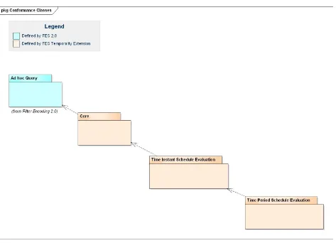
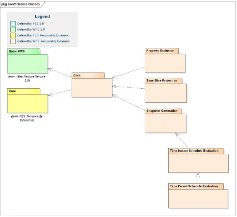
The following figures outline the conformance classes defined by this specification.
Details and the definition can be found in Annex E.
2
Copyright © 2014 Open Geospatial Consortium
Figure 2: WFS Temporality Extension Conformance Classes
3
References
The following normative documents contain provisions that, through reference in this
text, constitute provisions of this document. For dated references, subsequent
Copyright © 2014 Open Geospatial Consortium
3
[1]
ISO/DIS 19142 and OGC 09-025r1, OpenGIS® Web Feature Service 2.0 Interface
Standard (2010-11-02)
[2]
ISO/DIS 19143 and OGC 09-026r1, OpenGIS® Filter Encoding 2.0 Encoding
Standard (2010-11-22)
[3]
OGC 11-093r2, OGC® OWS-8 Aviation Architecture ER (2011-09-30)
[4]
OGC 11-073r2, OGC® OWS-8 Aviation: Guidance for Retrieving AIXM 5.1 data
via an OGC WFS 2.0 (2011-11-04)
[5]
OGC 10-131r1, OGC® OWS-7 Aviation – AIXM Assessment Report
(2010-08-18)
[6]
OGC 05-007r7, OpenGIS® Web Processing Service (2007-06-08)
[7]
XQuery 1.0: An XML Query Language (Second Edition), W3C Recommendation
14 December 2010, at
http://www.w3.org/TR/2010/REC-xquery-20101214/
[8]
OGC 11-171, Requirements for Aviation Metadata - OGC Best Practice
(2011-11-10)
[9]
OGC 11-172, Guidance on the Aviation Metadata Profile (2011-11-10)
[10]
AIXM 5 Temporality Model 1.0 (2010-09-15)
[11]
Lake R. et al., GML Geography Mark-Up Language, Wiley 2004
[12]
“Donlon” data set,
https://extranet.eurocontrol.int/http://webprisme.cfmu.eurocontrol.int/aixmwiki_public/bi
n/view/Main/XML_Tags#HExampleDonlondataset
(2014-04-26)
4
Conventions and Abbreviated Terms
4.1
Abbreviations
AIP
Aeronautical Information Publication
AIRAC
Aeronautical Information Regulation And Control
AIXM
Aeronautical Information Exchange Model
4
Copyright © 2014 Open Geospatial Consortium
ER
Engineering Report
FES
Filter Encoding Specification (Version 2.0 – if not stated otherwise)
GML
Geography Markup Language
HTTP
Hypertext Transfer Protocol
ISO
International Organization for Standardization
NOTAM
Notice To Airmen
OGC
Open Geospatial Consortium
UML
Unified Modeling Language
URL
Uniform Resource Locator
W3C
World Wide Web Consortium
WFS
Web Feature Service (Version 2.0 – if not stated otherwise)
WPS
Web Processing Service
XML
eXtended Markup Language
XPath
XML Path Language
4.2
Namespace bindings for XML elements
Prefix
Bound Namespace
gml
http://www.opengis.net/gml/3.2
aixm
http://www.aixm.aero/schema/5.1
fes
http://www.opengis.net/fes/2.0
wfs
http://www.opengis.net/wfs/2.0
fes-te
http://www.opengis.net/fes-te/1.0
wfs-te
http://www.opengis.net/wfs-te/1.0
Copyright © 2014 Open Geospatial Consortium
5
5
AIXM 5 Temporality Model
AIXM 5 is based on GML 3.2. All features inherit from the type
gml:DynamicFeature
which is the base class of the GML Dynamic Feature Model (DFM). The properties of a
feature are all time-variant and encoded in time slices. The only exceptions to this are
global identifiers, names, metadata and a bounding box. A detailed comparison of the two
models is given in 5.6.
The following section describes issues with the GML Dynamic Feature Model. Then a
brief introduction is given to the AIXM Temporality Model and to what makes it special
compared to the Dynamic Feature Model in GML 3.2.
5.1
Issues with GML DynamicFeature Model
The GML 3.2.1 standard [OGC 07-036] defines the UML model and XML Schema
encoding of the DynamicFeature, DynamicFeatureCollection and AbstractTimeSlice
types. The UML model is provided in [OGC 07-036] D.3.11 while the XML Schema is
defined in section 14.5 of that document.
The GML standard provides an example (see [OGC 07-036] section 14.5.7) in which a
cyclone is modeled as a DynamicFeature, with its movement status captured in time
slices that together constitute the history of the cyclone.
GML does not define modeling and management aspects of dynamic features in
sufficient detail:
Modeling/encoding:
o
GML does not clearly specify the rules for modeling and encoding
dynamic features.
Section 14.5.1 says that “… dynamic feature classes will normally
be extended to suit particular applications.”
Section 14.5.3 states that “this [the gml:dynamicProperties group]
allows an application schema developer to include dynamic
properties in a content model in a standard fashion.” That the
gml:dynamicProperties group allows the inclusion of dynamic
properties in a content model causes confusion, as it may suggest
that it is this group which needs to be extended by an Application
Schema developer – although no UML type exists for this group.
Section 14.5.6 says: “A timeslice encapsulates the time-varying
properties of a dynamic feature - it shall be extended to represent a
time stamped projection of a specific feature.”
o
These statements suggest that the DynamicFeature and AbstractTimeSlice
types are extended when modeling a specific DynamicFeature type in an
Application Schema by adding the same properties to both of them. This
would then enable snapshots as well as the full feature history to be
6
Copyright © 2014 Open Geospatial Consortium
to be optional to enable representation of snapshots and the complete
feature history.
Management:
o
Section 14.5.4 in GML states that “each time-stamped instance [of a
dynamic feature] represents a ‘snapshot‘ of a feature.” This appears to
refer to the gml:validTime, which is an optional property of a GML
DynamicFeature type. However, the relationship to gml:validTime is not
explicitly stated there. Section 14.5.5, though, states that “a
gml:DynamicFeatureCollection is a feature collection that has a
gml:validTime property (i.e. is a snapshot of the feature collection)”
which provides a hint that this assumption is correct.
o
GML also does not clearly define what a snapshot is if the ‘time-stamp’
(presumably the gml:validTime) is not a gml:TimeInstant (or a
gml:TimeNode). Again the reader is forced to make assumptions, though
an obvious assumption would be that if a gml:TimePeriod or –Edge is
given for a ‘snapshot’ that then the state of the dynamic feature is constant
for that time.
o
GML does not define how to solve situations in which multiple time slices
contain a value for a dynamic property for a given point in time. The
AIXM-TM avoids this potential ambiguity through the definition of
sequence and correction numbers for time slices.
o
Other application aspects that are covered in the AIXM-TM, such as deltas
for complex or multi-occurring properties, or canceling a time slice are not
defined in GML.
Apparently the GML standard only defines the basic model and encoding of the dynamic
feature base type. Actual rules for modeling/encoding and management of specific
dynamic features that are defined in an Application Schema are neither covered in GML
3.2.1 nor in the current OGC or ISO standards baseline.
5.2
Time Slice Interpretation
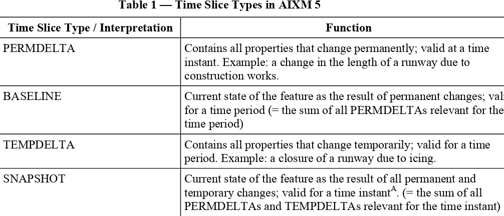
AIXM 5 distinguishes four types of time slices: BASELINEs, PERMDELTAs,
TEMPDELTAs and SNAPSHOTs. The time slice type is encoded in a time slice property
called ‘interpretation’. From now on, the term
time slice interpretation
may be used as a
synonym to
time slice type
in this document. The function of the time slice types are
described in Table 1. BASELINEs and SNAPSHOTs are the direct result of
PERMDELTAs and TEMPDELTAs, which means that they are only a different
Copyright © 2014 Open Geospatial Consortium
7
Table 1 — Time Slice Types in AIXM 5
Time Slice Type / Interpretation
Function
PERMDELTA
Contains all properties that change permanently; valid at a time
instant. Example: a change in the length of a runway due to
construction works.
BASELINE
Current state of the feature as the result of permanent changes; valid
for a time period (= the sum of all PERMDELTAs relevant for the
time period)
TEMPDELTA
Contains all properties that change temporarily; valid for a time
period. Example: a closure of a runway due to icing.
SNAPSHOT
Current state of the feature as the result of all permanent and
temporary changes; valid for a time instant
A
. (= the sum of all
PERMDELTAs and TEMPDELTAs relevant for the time instant)
A
The concept of snapshots is extended to time periods later in this document
SNAPSHOT time slices cannot be stored in a WFS and a WFS cannot retrieve them from
a persistent storage. This is because in theory, an unlimited number of SNAPSHOT time
slices exist as they are valid for a single point in time only.
5.3
Sequences, Corrections and Cancelations
An AIXM 5 feature never forgets its history, which includes expected events on the state
of a feature to happen in the future, that were known at some point in the past. This
implies that a time slice is never deleted or updated. Every change is communicated
through the insertion of new time slices, for which overwrite rules apply. For this purpose
AIXM 5 introduced the concepts of
sequences
,
corrections
and
cancelations
. Every time
slice of a feature has a unique identifier (key) which consists of the following properties:
the interpretation (time slice type),
the sequence number and
the correction number
For every sequence (i.e. the set of time slices that share a sequence number), there is
always only one
active
time slice: it is the one with the highest correction number. All
time slices with a lower correction number (in a sequence) are considered to be outdated.
If the active time slice is a cancelation, which is indicated by a specific value of the
validTime property, then the sequence is considered to be canceled
1
. This functionality
8
Copyright © 2014 Open Geospatial Consortium
supports communicating both updates and deletions without losing the history. For
simplification we define:
a
sequence
: the set of time slices of a feature that share the same interpretation value
and sequence number
the
active time slice
: the time slice of a sequence with the highest correction number
a
canceled sequence
: a sequence whose active time slice is a cancelation
canceled time slices
: the time slices of a canceled sequence
corrected time slices
: all time slices of a sequence except the active time slice
5.4
Lifetime of a feature
AIXM 5 defines two time slices that mark the beginning and the end of the feature’s
lifetime. They are called commissioning and decommissioning time slices, respectively.
Both are PERMDELTA time slices that contain a
featureLifetime
property. For
simplification we define:
commissioning
: the start of life / existence of a feature
decommissioning
: the end of life / time of withdrawal of a feature
lifetime of a feature
: the time period from commissioning to decommissioning, i.e. all
points in time that are not before and not after that period
5.5
Properties with Schedules
In AIXM 5, a special property type exists for modeling periodic events:
PropertiesWithSchedules
[10]. It introduces an additional temporality aspect to
properties which is overlaid onto the underlying temporality model. Good examples for
schedules are the opening times of an airport (e.g. daily 8-18h) and the regular activation
of airspaces for military operations (e.g. weekly on Saturday 8-16h). Schedules consist of
a list of consecutive time sheets, where each time sheet contains a validity period and set
of values.
5.6
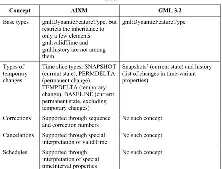
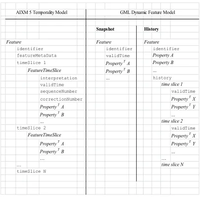
Differences to the GML Dynamic Feature Model
AIXM 5 is only loosely based on the GML Dynamic Feature Model. Important
differences exist both
Copyright © 2014 Open Geospatial Consortium
9
in the structure of the features (see Figure 3).
Table 2 — Differences between AIXM and GML temporality models, conceptual
level
Concept
AIXM
GML 3.2
Base types
gml:DynamicFeatureType, but
restricts the inheritance to
only a few elements.
gml:validTime and
gml:history are not among
them
gml:DynamicFeatureType
Types of
temporary
changes
Time slice types: SNAPSHOT
(current state), PERMDELTA
(permanent change),
TEMPDELTA (temporary
change), BASELINE (current
permanent state, excluding
temporary changes)
Snapshots
2
(current state) and history
(list of changes in time-variant
properties)
Corrections
Supported through sequence
and correction numbers
No such concept
Cancelations
Supported through special
interpretation of validTime
No such concept
Schedules
Supported through
interpretation of special
timeInterval properties
No such concept
10
Copyright © 2014 Open Geospatial Consortium
Snapshot
History
identifier
validTime
Property
T
A
Property
T
B
interpretation
…
validTime
sequenceNumber
validTime
correctionNumber
Property
T
X
Property
T
A
Property
T
Y
Property
T
B
…
…
validTime
Property
T
X
Property
T
A
Property
T
Y
Property
T
B
…
…
…
…
identifier
identifier
AIXM 5 Temporality Model
GML Dynamic Feature Model
Feature
Feature
Feature
featureMetaData
Property A
timeSlice 1
Property B
FeatureTimeSlice
…
timeSlice N
history
time slice 1
time slice 2
timeSlice 2
FeatureTimeSlice
time slice N
Figure 3 — Comparison of the XML structure in the AIXM 5 Temporality Model
and the GML Dynamic Feature Model
Figure 3
explained: each item below “Feature” represents an XML element (including the
Feature element itself). Because XML can be quite verbose, tags, attributes and namespaces have
been omitted because they are of little value in this comparison. Elements in
type
-writer
notation
denote real existing elements, whereas elements in italic letters denote elements of a
certain type or class. Feature properties specific to a concrete feature type fall into two classes:
time-variant properties (
Property
T
) and time-invariant properties (
Property
). The latter only exist
in the GML Dynamic Feature Model.
5.7
Conclusion
Copyright © 2014 Open Geospatial Consortium
11
between temporary and permanent changes, corrections, cancelations and properties with
schedules. However, both models share the approach of modeling time-variant data by
the introduction of time slices, which associate properties with a validity time. Most
important of all is that the AIXM Temporality Model completely defines how dynamic
features with time-varying property values are modeled, encoded, interpreted and
managed.
The Temporality Extension specified in this document defines the necessary additions to
FES 2.0 and WFS 2.0 that support specific data retrieval use cases required by the
Aviation domain. The Temporality Extension thus enables better support for retrieval of
AIXM data, but in general supports retrieval of dynamic feature data that follows the
principles of the AIXM Temporality Model. As outlined in [OGC 11-093r2] the
Temporality Model can become a standalone standard that extends the concepts of the
General Feature Model (GFM) to support modeling, encoding, interpretation and
management of dynamic features.
6
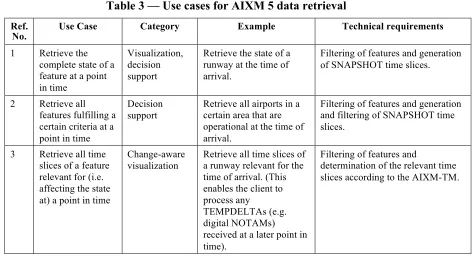
Use Cases for a WFS Service Serving AIXM 5 Data
6.1
Data Retrieval
The use-cases for the retrieval of AIXM 5 data are manifold and come from different
areas of applications. Table 3 categorizes them, gives examples and derives the technical
requirements for a query processor.
Table 3 — Use cases for AIXM 5 data retrieval
12
Copyright © 2014 Open Geospatial Consortium
Four technical requirements of a query operation on AIXM 5 data follow from this
analysis:
a)
The ability to filter features and time slices.
b)
A filter expression to easily identify corrected and canceled time slices
4
.
c)
A filter expression to easily identify the time slices that are relevant for a point in
time.
5
d)
The ability to generate SNAPSHOT time slices and to filter them.
These requirements will form the basis for the extensions introduced in sections 8 and 9.
3
For details on what BASELINEs are and how to compute them, see the AIXM-TM.
4
Identifying corrected time slices is not trivial using FES 2.0. The maximum correction number of a sequence has to
be calculated for this purpose, which would involve a complex XPath expression.
Copyright © 2014 Open Geospatial Consortium
13
6.2
Data Storage
Because AIXM-TM does not allow the permanent deletion of information
6
, there are only
two use cases:
a)
insert a feature
b)
insert a time slice into a feature
This is already possible with the existing
Transaction
operation. If a feature is inserted,
the
Insert
action has to be used. If a time slice is to be inserted, the
Update
action is
necessary, because technically, the feature is changed (updated) by adding a new time
slice to its list of properties.
EXAMPLE
Insertion of a time slice into a feature of type T, with a gml:identifier I. Please note that the order of
the time slices is irrelevant in AIXM.
<
<
<
< a
<
<
<
. . .
<
<
<
<
fes
F
< ! " #
< g <
< $ ! < $
< ! " #
<
fes
F
<
<
7
Limitations of the WFS/FES 2.0 standards when applied to AIXM data
In this chapter we will show that there is only little support for the identified
requirements in the WFS 2.0 and FES 2.0 standards.
The WFS 2.0 interface provides two operations for retrieving data:
GetFeature:
returns a response containing a selection of zero or more features
corresponding to the criteria defined in the request
GetPropertyValue:
returns a response containing zero or more of the selected
feature property values corresponding to query criteria defined in the request
14
Copyright © 2014 Open Geospatial Consortium
There is also a
GetFeatureWithLock
operation, but this does not extend the power of
the query language compared to
GetFeature
and is therefore ignored in the following.
Both the
GetFeature
and
GetPropertyValue
operations support two types of query:
wfs:Query:
these are ad hoc queries generated by a client to retrieve specified feature
types or property values
wfs:StoredQuery
: this is a pre-defined parameterized query that has been stored on
the server for re-use by clients
In the following it is shown that neither of them fully supports the requirements identified
in the previous section.
7.1
GetFeature
The
GetFeature
operation request is used to retrieve features using one or more ad hoc
queries (
wfs:Query
) or stored queries (
wfs:StoredQuery
).
7.1.1
Ad Hoc Queries
The
wfs:Query
element consists of two parts: a selection and a projection part.
The selection part is a FES 2.0 filter expression and selects the features matching given
criteria. An additional selection criterion is given by the
typeNames
attribute on the
wfs:Query
element: it is used to restrict the types of features to be returned.
The projection part is optional and may contain one or more projection clauses. In WFS
2.0, there is only one projection clause available:
wfs:PropertyName
. By default,
non-mandatory properties of a feature are not returned in the response document unless they
are referenced by a
wfs:PropertyName
element in the request. In WFS, the properties of
a feature are made up of all first-level child elements of the feature. For AIXM 5 data
these are the gml:identifier, gml:name, gml:description, gml:boundedBy,
gml:featureMetadata and aixm:timeSlice elements. Except for the list of aixm:timeSlice
elements, all of these are non-mandatory. Thus, the
wfs:PropertyName
clause enables
the client to include gml:identifier, gml:name, gml:description, gml:boundedBy,
gml:featureMetadata in the response which are excluded otherwise.
Obviously the
wfs:PropertyName
projection clause was designed for static feature data
only, where all properties are encoded in the feature’s first-level child elements. In the
DynamicFeatureQuery
class introduced in 9, we also introduce
PropertyExclusion
,
which replaces
wfs:PropertyName
and is capable of handling dynamic feature
properties as well.
Copyright © 2014 Open Geospatial Consortium
15
support neither for the generation of SNAPHOTs nor the filtering of time slices. Only the
use case “Retrieve the full history of a feature“ is supported.
7.1.2
Stored Queries
From the specification:
“A stored query expression is a persistent, parameterized, identifiable query
expression. A stored query can be repeatedly invoked using its identifier with
different values bound to its parameters each time.” [1] 7.9.3.1
Stored queries can use any language to implement their behavior. The given parameters
can be of any type. Hence, stored queries naturally have the power to support all AIXM 5
use cases
7
. Those queries could be predefined
8
for the server and tailored to the required
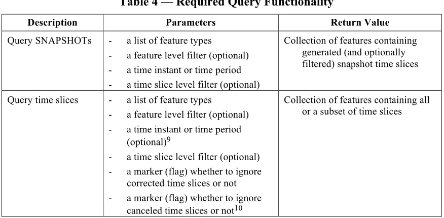
use cases. Table 4 shows that 3 different queries would be required. That said, what are
the reasons that this paper does not simply define stored queries but instead promotes the
introduction of new types for WFS 2.0 and FES 2.0? They are:
Demanding predefined stored queries is not very different from introducing a new
query type: generic WFS 2.0 clients cannot support any of them because they cannot
know about the semantics of the query parameters or elements.
Using predefined stored queries would require the definition of the overall semantics
involved in the execution of these queries. Basically, this would result in the
definition of a new query language or in the extension of an already existing one. The
latter is what this document does. By extending the
wfs:Query
and adding
functionality tailored to the AIXM-TM, queries with Temporality Extension
functionality can be executed in both ad hoc and stored queries.
The intended use of stored queries is to parameterize complex queries to improve
readability, speed up server processing (by query pre-compilation on server side) and
reduce the amount of text in the request document. Typical parameters are concrete
values or objects like numerical values in a certain unit of measurement, a spatial
object for comparison, etc.
For temporal queries, however, the parameters include complex filters, which are
used to define the query itself, and because of which the query cannot be
pre-compiled.
7
The specification says ‘A stored query expression may be used in a [,,,] GetFeature […] operation to identify a set of
features to be operated upon’ ([1], section 7.9.3.1). Strictly speaking, this implies that no transformation of features can
take place and hence no time slice selection or snapshot generation is possible. However, we are not sure if this was the
intention of the standard and assume for the following reasoning that the result of a stored query can be an arbitrary set
of features, new ones or modified ones.
16
Copyright © 2014 Open Geospatial Consortium
Table 4 — Required Query Functionality
Description
Parameters
Return Value
Query SNAPSHOTs
-
a list of feature types
-
a feature level filter (optional)
-
a time instant or time period
-
a time slice level filter (optional)
Collection of features containing
generated (and optionally
filtered) snapshot time slices
Query time slices
-
a list of feature types
-
a feature level filter (optional)
-
a time instant or time period
(optional)
9
-
a time slice level filter (optional)
-
a marker (flag) whether to ignore
corrected time slices or not
-
a marker (flag) whether to ignore
canceled time slices or not
10
Collection of features containing all
or a subset of time slices
7.2
GetPropertyValue
From the specification:
“The GetPropertyValue operation allows the value of a feature property or part of the
value of a complex feature property to be retrieved from the data store for a set of
features identified using a query expression.” [1] 10.1
In other words,
GetPropertyValue
is a combination of a
GetFeature
request and an
XPath expression. A given filter is used to select features by criteria (this is the regular
GetFeature
operation), and in a subsequent process the XPath expression is used to
extract XML elements out of the result.
One of the requirements is to generate and filter SNAPSHOT time slices. This
requirement cannot be met by the
GetPropertyValue
operation, because the XPath
expression is only capable of identifying a feature property (or any of its sub-properties)
11
(for the discussion to use stored queries for this, see above). Another central requirement
is the capability to filter the list of time slice properties contained in the feature. This is
possible with
GetPropertyValue
. However, significant disadvantages are observed:
9
Avoids a lengthy check on the valid time in the time slice filter.
10
The two markers are technically time slice filters, but cannot be realized with the subset of XPath syntax defined for
FES.
Copyright © 2014 Open Geospatial Consortium
17
The filter criteria for time slices are likely to be quite complex. Spatial and temporal
criteria are required for almost every common use case. The existing FES operators
cannot be used for this purpose, because they are not available as XPath functions.
Further on, custom XPath functions have to be introduced to make the exclusion of
corrected and canceled time slices possible.
The XPath expression has to be encoded in a single string. This string cannot be
validated through an XML schema. The expression will be very hard to read (and
debug) for humans, especially if complex spatio-temporal functions are involved.
The result of a
GetPropertyValue
operation is a collection of XML elements. In our
case, these are timeSlice elements. A timeSlice element does not contain a reference
to its parent feature. In addition, the
GetPropertyValue
operation response does not
indicate which property values contained in the response belong to which features.
Together this means that if property values from multiple features are contained in the
result, the result is ambiguous.
7.3
Summary
This chapter showed that WFS 2.0 and FES 2.0 were designed to support static feature
data, following the General Feature Model. They do not support the use cases for
querying AIXM 5 data. Predefined stored queries can work around this limitation. In
chapters 8.28 and 9 we will introduce extensions to FES 2.0 and WFS 2.0 as a general
solution that works with ad hoc and stored queries.
8
Filter Encoding Specification Temporality Extension
The following requirements classes extend the Filter Encoding Specification by filter
constraints based on time.
8.1
Terms and Definitions
In addition to the definitions from 5.3 and 5.4 we extend the concept of SNAPSHOT time
slices to time periods and introduce a dummy time slice to work around schema
validation issues.
8.1.1
Dummy Time Slice
The projection and transformation clauses introduced may produce features without time
slices in some cases. As this is not schema-valid, and we cannot redefine or relax the
schema of the features returned by the service, we need to introduce a
dummy time slice
to work around this limitation. A dummy time slice is structured as follows:
% & ' ( ) * + ' ) , / 0 ' 1 , 2