CHAPTER I
INTRODUCTION
1.1. General
Disaster is an event, natural or man-made, sudden or progressive, which impacts with such severity that affected the community, has to respond by taking exception measures (Carter, 1991). The disaster has been occurring in human civilizations as long as recorded history, and presumably even longer. Human from generation to generations have had to withstand the disaster until today. In fact, disaster always gives negative impacts for human civilization. However, on small scale of disaster are still threaten human being. These disasters have been continuing causing grievous human casualties, economic, social loss, culture, and damage to the environment. There are so many lives gone and many properties have lost caused by the disaster. However, the disasters are caused by different factor which challenges the modern society. (Carter, 1991):
a. First factor is that there has not been very much reduction in what might be called the traditional disaster. It includes natural phenomena such as: earthquakes, volcanic eruption, tsunamis, wildfires, floods, landslides, and droughts, which are most of the old problems, and still exist.
b. Second factor which bears upon today’s situation is the new disaster threat have developed, particularly since World War II. For instances, high jacking, terrorism, civil unrest, and conflict with conventional arms have become, commonplace, generally termed hazardous material or substances like atom, nuclear, etc.
c. Third factor concern what might be called the geography of disaster. Disaster can be strong aggravating factor in differences between wealthy nations and poor nations, that is, between the “haves” and the “have-not”. d. Fourth factor is relationship between the contemporary disaster threat and
the losses it may impose.
by disaster. To overcome these problems, people from all levels of society must cooperate to manage the disaster integrated. It needs an absolute awareness of the society and public participation to minimize disaster impacts. Therefore, these efforts need a proper management which called disaster management. Disaster management is an applied science which seeks, by the systematic observation and analysis of disaster, to improve measures relating to prevention, mitigation, preparedness, emergency, recovery (Carter, 1991). Disaster management is a continuously measure, and it is not periodic measure. The following types of disaster are (Carter, 1991):
1. Earthquakes. 2. Volcanic eruptions. 3. Tsunamis.
4. Tropical cyclone (typhoon, hurricane). 5. Floods.
6. Landslides.
7. Bushfire or wildfire. 8. Drought.
9. Epidemic. 10. Major accident. 11. Civil unrest.
From the types of disaster above only flood which will be described more intensely in this final assignment. Flood is common problem which always occurs in many regions in Indonesia, especially in the dense populated areas. Floods are a natural disaster that have been affecting human since time immemorial. A flood is a ‘great of water, causing overflow and inundations’ (Chambers, 1981). Commonly it is considered to be a phenomenon associated with an unusually high stage or over land or coastal area, which results in serve detrimental effect. In nature, the problems associated with floods inundate built-in property, endanger lives, and prolonged high flood stages delay transportation traffic (Ghosh, 1996). There are some causes which make floods (Kodoatie and Sugiyanto, 2002):
b. Trash / waste.
c. Erosions and sedimentation.
d. Slum along the riverbank / drainage are included illegal building. e. Incorrect planning of floods control.
f. Rainfall intensity. g. Geophysics of river.
h. Ability of river / drainage capacity. i. Affect of the water tide (rob). j. Land subsidence.
k. Drainage system. l. Dam.
m. Damage of flood control.
Changes of land use are the major factor which causes floods. For instance, some regions have been changed from a forest into residences. This transformation of land use decreases rainfalls infiltrating into the soil. It will make run off increase, and will make discharge of river increasing from 5 to 20 bigger than before. Simple and quantitative of land use changing shown on figure 1.1.
10 23 17 25
Figure 1.1 Increasing discharge effect of land use changing, forest as reference
Floods have many characteristic as follows (Carter, 1991):
a. Long, short or warning, depending on type of flood (e.g. flooding within part of major river may develop over a number of days or even weeks, whereas flash flood may give no usable warning).
b. Speed of onset may be gradual or sudden. c. There may be seasonal patterns to flooding.
d. Major effects arise mainly from inundation and erosion; specifically, they may include isolation of communities or areas, and involve the need for large-scale evacuation.
The same with other disasters, floods always give negative impacts. Identification of the losses from the flood impacts might be direct or indirect. The following are some examples affect that caused directly by the flood:
a. Loss of life’s and / or injures. b. Loss of properties.
c. Infrastructure damage, etc.
Flood impacts which effect indirectly are: a. Disturbed of education.
b. Health.
c. Communication disruption. d. Economic problems. e. Social problems, etc.
1.2. Background
Semarang City is one of the biggest cities in Indonesia. Semarang is located in the north of Central Java. It lies from 6º50’ to 7º10’ of south latitude and from 109º35’ to 110º50’ of east longitude. The territory of Semarang municipality shows on map 1.1. Semarang municipality has border to other district in Central Java Province, they are:
a. West boundary : Regency of Kendal.
c. South boundary : Regency of Semarang. d. North boundary : Java Sea.
The width of Semarang municipality is 37370, 39 hectare. The existing width consists of 3956, 30 hectare rice field and 33414,09 hectare are dry field, most of dry field are use as yard and housing. Total population on Semarang municipality is 1.419.478 peoples which consist of 705.627 male and 713.851 female (BPS, 2005). Semarang is a unique municipal, because this city is divided into two regions. The southern is a hilly region and the northern is a low land. Semarang is a capital of Central Java province. Therefore Semarang City has developed become a metropolitan city. Because of this development, many areas are covered by road and buildings or other changing of land use which makes water can not infiltrate into soil. Land use changing gives dominant contribution to run-off. Furthermore, land use transformation makes coefficient run-off will increase, this condition will make surface run-off also increase and will make floods.
As happens in other big cities in Indonesia, Semarang has potency to happen a disaster especially floods. The north side of Semarang City has many areas which have possibility of flood strike, rob mainly. Because it elevation has not significant differences with the water sea level. Even, some elevation regions are under the water sea level. Nowadays, the inundation happens not only in wet season but also on dry season caused by tide level. The water level which effected tide level will make back water on the rivers and drainages which are empty into the sea furthermore will cause the inundations. The inundations will cause problems for peoples and the existences of environment. If floods happened annually, it will increase the losses.
1.3. Purposes and Objectives
a. To understand measures of floods treatment with non structural method in north Semarang City.
b. To find out the cycle of disaster (flood) management from pre until after disaster.
c. To understand the right non structural measures to manage floods.
d. To identify the implementation measures of non structural method on flood prone areas in North Semarang City.
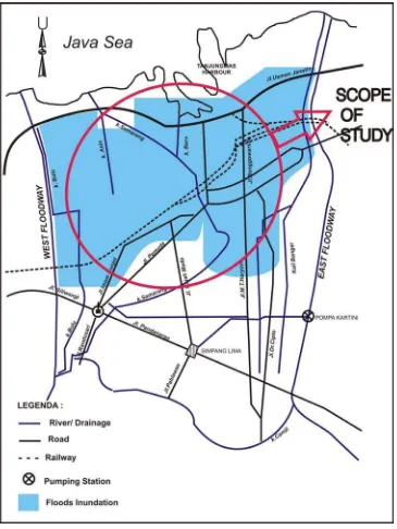
1.4. Scope of Report
Figure 1.2 The spatial scope of study between west and east flood ways
1.5. Organizing of The Report
ed of this final assignment is as follows:
R I BACKGROUND
the general, background of the topic that was chosen as ent, the purpose and objectives of the study, scope of study contains substances scope d the out line of assignment. The outlin
CHAPTE
This chapter contains of the core of this assignm
CHAPTER II LIT
This chapter contains of the theories a relevant to the selected topics, basic epts s with the issues of study based on various literatures.
Semarang City as the object of is research, including geographical condition, also social condition.
HAPTER V ANALYSIS OF NON STRUCTURRAL METHOD
primer also secondary hich have correlations with floods in Semarang City, Non structural measure are
anaging the isaster especially floods in Semarang City.
ERATURE STUDY
re conc in relation
CHAPTER III METHODOLOGY
In this chapter contains of methodology, achieving data method, sampling method, conceptual approach, and methodology data analysis.
CHAPTER IV GENERAL CONDITION OF NORTH SEMARANG
CITY
This chapter consists of general condition north th
C
FOR DISASTER (FLOOD) MANAGEMENT IN
SEMARANG CITY
This chapter mainly contains about the analysis of data w
expected have obtained from the analysis. This chapter also contains with the structural method as an alternative solution for coping flood which is river’s normalization in Semarang River.
CHAPTER VI CONCLUSION AND RECOMENDATION
This chapter contains of the conclusions of the study, and also the recommendations, due to the future disaster management for m