International Conference on Sustainable Infrastructure and Built Environment in Developing Countries November, 2-3, 2009, Bandung, West Java, Indonesia
ISBN 978-979-98278-2-1
The Density, Road Network Pattern Identification and Isoprice Perspectives (Case Study in Semarang City-Central Java)
Ferry Hermawan1,*, Ismiyati1 1
Lecturer of Civil Engineering –Engineering Faculty of Diponegoro University Jl. Prof. Sudharto,SH Tembalang Semarang,Central Java, Indonesia
Phone: +62 24 7474770 Fax: +62 24 7460060 cell: 0811-271463 *Corresponding author: [email protected]
Abstract
The endowment problems of urban growth is the density. Based on the Land-Rent theorem, people move to suburban area. After that, the access is built to accommodate people’s activities. This article describes the density, road network pattern identification and isoprice as the new approach to capture the macroscopic evaluation. By using literature study from previewed study and spatial methodology by geographic information system, the problems are simulated quantitatively. The result of this study indicates that Semarang City has radial concentric topology with pattern of density commencing to south district with cheaper cost of transportation in the dense network of public transportation.
Keywords: density, isoprice, road network pattern.
1. Background
While cities occupy only two percent of the earth’s landmass, they contain 50 percent of world population, consume 75 percent of the world’s resources and produce 75 percent of its waste, the overriding priority of 21st century planning and urban design will support the global agenda for environmental responsibility, social equity, and economic opportunity for all people. That challenge, in turn, is inexorably linked to the sustainability of the world’s cities and urban areas. (Fornos, Desikan T. and Burdett in Watson et al., 2003). In 1900, only 160 million people or one-tenth of the world’s population lived in cities. In 2000, half of the world population or more than 3 billion people were urban dwellers. In the last hundred years, world population has grown from about 1.6 billion to 6 billion. This almost four-fold increase is accompanied by an alarming twenty-fold increase in the world’s urban population. The most rapid urban growth over the next two decades is expected to occur in cities with populations from 250,000 to one million. The total annual growth of such cities is currently more than 28 million per year. Fifteen years from now, it will increase to 31 million per year. The concentration of population in urban areas has generated a growing need for land for urban development as well as public services to support it. In addition, the decentralization of job centers to the suburbs, the availability of automobiles coupled with abundant highways, and the pursuit of single-family homes have drawn people to outlying areas for housing
(Suen, 2005). In Wheaton and Schussheim’s (1955) study, the effects of development
water, and drainage varied with the length of street per dwelling, which in turn was a direct function of lot size. This study also pointed out that infill developments produced the lowest costs of all by maximizing the use of available capacities in schools, roads, sewers, water, and fire systems. Isard and Coughlin (1957) also analyzed the costs of roads, sanitary sewers, storm sewers, and schools for developments with various densities. Their findings indicated that higher development densities usually incurred lower costs of public services per dwelling unit as compared with other development patterns. Kain (1967) investigated the impact of density, lot size, and urban form for different urban services and identified that the cost of facilities depends primarily on the shape and size rather than density of the region being served.
Java island is one part of Indonesian Archipelago. More than half of the Indonesian people live in Java (Statistic of Indonesia, 1930-2005). There is one megapolitan city, Jakarta, and five Metropolitan cities: Bandung, Semarang, Yogyakarta, Surakarta or Solo and Surabaya. Most of their citizens prefer to live in the urban area. Transportation problem is getting more complicated day by day. For example, in 2009, Jakarta needs the Ring Road freeway as an alternative of congestion (Kompas, 2009) but the vehicle rate grows very rapidly. Even though the public transportation in Jakarta as megapolitan meets that situation, this typical problem solving is sometimes impossible to be adopted in other cities. There are limited infrastructures in the urban area that cause low services even though the technology became more excellent year by year. The private automobile or motorcycle is the biggest contributor of traffic congestion, while the public transportation is usually not comfortable enough. The planning system of infrastructure also has an important role in the economic growth. But the generalized system planning does not match with the local characteristic of the certain city (metropolitan cities). The equilibrium of demand-supply in transportation system cannot match with the Four Step Model as Conventional Method of Transportation Solution. So the research on the local characteristic will be an important thing to do in the future. Sustainable Transportation will be a part of World Energy Conservation, therefore this article will discuss about the behavior of characteristic based on density, road network and isoprice as a new approach for transportation paradigm in the future.
2. Objectives
The objectives of this article are :
1. To identify the density and road network pattern and isoprice perspectives related to behavior of city consumption in Semarang city.
2. To describe the demand pattern based on the density, road network pattern which impact the urban activities.
3. Methodology
The methodology used in this research apply the literature study from the previous research and combined by quantitative approach with spatial tools of density, network pattern from street and isoprice in the certain sampling area of location study. The spatial matters described by 3D view, the network pattern by comparative study with the typology of street pattern theoretically and the isoprice as the demand review in the scope of study of the dense area.
4. Data Collection
5. Literature Review
The center of gravity will be the main point in which the average distance per person is the shortest. One can also identify special areas of the city such as its central business district (CBD). One will be able then to calculate what the average distance per person to the CBD is and whether the CBD and center of gravity are coincidence. Suen (2005) research about residential development pattern is characterized by residential parcel density and an aggregated parcel shape index. The analysis factor shows that the length of streets is an appropriate indicator to represent overall infrastructure provision. Logarithmic multiple regression analysis reveals a good relationship between residential development pattern and infrastructure provision variables. Parcel shape has a stronger influence on infrastructure provision than parcel density does, and together they explain more than 55% of the variation in infrastructure provision. The results of this empirical study establish a mean to evaluate development proposals on the basis of development pattern and the associated infrastructure provision cost.
Most residential location models in urban economic-related studies are originated from Alonso’s location model (Alonso, 1964). That model assumes that all workplaces are concentrated in a highly compact central business district (CBD) on the side of city configurations. Commuters’ homes are continuously dispersed over the residential area surrounding the CBD. All commuters are employed at the CBD. Only homogeneous surface streets are assumed to be available on the side of transportation systems. Thus, the complicated two-dimensional city configuration can be simplified to a one-dimensional round city.
6. Result and Discussion
6.1. Transport opportunities for high urban densities
The opportunity that high urban density presents to public transport is exemplified by the case of Hong Kong, where in 1990 public transport carried 82% of all motorized passenger kilometers traveled. (Barter, 2000). Another opportunity presented by high densities is the possibility that many trips can be short and therefore easily made on foot or by non-motorized vehicles. In Asia the urban density versus proportion of public transport demonstrates that a significant role for non-motorized transport is possible even in medium-density cities. In theory, there is considerable potential for non motorized transport to play a large role in dense Asian cities. (Barter, 2000). The cities of the United States having, on average, among the lowest urban densities, the highest usage of private motor vehicles and the lowest use of public transport. The Asian cities are, on average, at the opposite extreme, with high densities, low vehicle use and high public transport use. The European, Canadian and Australian cities fall between these extremes.
6.2. The Density of Semarang
Semarang density has the typical typology with Jakarta, the megapolitan. The density grows to South region. Jakarta has more than ten million people with the area about 2.942 square kilometers. Until 2009, the jobs centralized to CBD like Sudirman, Thamrin, Monas etc. The trend of settlement growth gradually commences to South Jakarta.
Spatially, the people growth direction is to South East and South of Semarang City. Starting along corridor of Pedurungan district in the southeast and commence to Banyumanik, Tembalang and Gunungpati in the south of Semarang. Land used of south district is concentrated as settlement area. Spatial growth of the people from the expansion district is described from 1994 until 2006. There are two phases of settlement growth in Semarang, the first step is linier along the regional access to Southeast and South district, then braided growth as a network within the dense resident of settlement area. It would be the reason of the phenomenon of the grid network in some settled areas as described before.
6.3. Road Network Typology and Consumptions of the City
The complexities of shape and structure set street pattern apart from many other objects of urban or transport analysis. There is no straightforward or standard descriptor that is used to capture street pattern. (Marshall, 2006). The typology introduced here has been developed with the intention of reflecting typical street patterns that are encountered in different kinds of urban analysis. The four types are best introduced by considering different patterns featuring at different stages of growth of towns and cities, arranged as if stretching outwards from the historic core of a settlement to its outskirts (Figure 1).
Figure 1 ABCD typology as transect. The four types are presented as if extending out from
the core of a settlement (left) to the periphery (right). Not all types are necessarily present or in order; but normally, where present, the A-type would be the core and the D-type at the periphery. (Marshall, 2006).
One way to elaborate on this complex relationship between consumption and place is to look at a specific example of a significant tourist site that is also a site of everyday consumption, making the familiar strange. One good example is highlighted by Peter Jackson in 1998, who suggested that since the nineteenth century, or the year before, ‘the street’ has been regarded as a lively and contested public domain, the site of popular protest and political struggle. Similarly, Valentine in 1998 discussed the relationship between consumption and streets. She suggested that in western cities there has been a long ‘civilizing process’ in defining what is acceptable to do in the street and when behavior is out of place. For example, in medieval times it was commonplace for people to eat, belch, fart, spit, shit, and so on in public. Today, such antisocial behavior would of course be frowned upon (Jayne, 2006).
social impacts of increased private transport.(Jayne, 2006). Hall (2003) argues that there are important issues of social exclusion in terms of individuals’ lack of access to and hence participation in civic resources and opportunities. He argues that social exclusion has been exacerbated by the increased domination of the automobile of the planning and landscape of the city. Moreover, urban life is also qualitatively degraded by traffic and it has been shown that social interaction on streets declines as traffic volume increases. Where the car dominates our cities it is often to the detriment of human interaction and the marginalization of the social and cultural life of urban areas.
6.4 Pattern of Road Network in Semarang
Shape has proven one of the most elusive of geometric characteristics to capture in any exact quantitative fashion. (Haggett and Chorley, Network Analysis in Geography within
Marshall, 2006). Semarang commonly has the radial concentric typology. But some of the
components are linier and grid along the certain part. North district of Semarang has an old city typology, with the dense configuration of street network. The linier pattern growth separates along the road at suburban area, like Mijen sub district, Gunupati sub district and South of Banyumanik sub district. The CBD reference is Simpang Lima area. The trend of growth pattern of road network become a triangle formation with tree major directions to Genuk sub district (Suburban-4), to Tugu and Mijen sub district (Suburban-1) and to Banyumanik-Tembalang sub districts (Subdistrict-2 and 3). The schematic diagram of road network in Semarang can be seen in Figure 2. below.
Figure 2. The Road Network Development Direction of Semarang City (Analysis, 2009)
The direction of road pattern is conducted by the settlement growth trends in each region and sub district. Based on the Alonso’s (1964) that workplaces are concentrated in a highly compact central business district (CBD) on the side of city configurations suit with old city configuration would be realistic. The fact is residential areas are surrounding the CBD of the old city in Kauman area (Central sub district). The other reasons of Alonso match with homogeneous surface streets assumed to be available on the side of transportation systems. This modern development of Semarang City will not match with Semarang because the hilly land of Semarang in the recent years become dense as settlement area such as Perumnas Banyumanik, Gunungpati Resident, Pudak Payung Resident, Graha Estetika Real Estate,
CBD OLD CITY
Sub Urban‐1
Sub Urban‐2
Sub Urban‐4
North‐Coastal
Sub Urban‐3
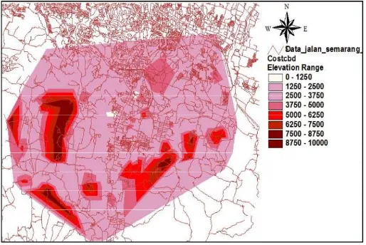
Gedawang Resident etc. The dense area such as settlement area influences the level of payable people in the suburban area. Hermawan (2008) used the isoprice model with Geographic Information System tools to describe the people’s cost of transportation. The research is done by using questionnaire and price index of cost transport in 3 sub districts (Banyumanik, Tembalang and Gunungpati area) along the public transport trajectory. The cost transport is interpolated then the isoprice is constructed as shown in Figure 3.
Figure 3. Isoprice of Public Transport Service Area in Banyumanik-Tembalang and
Gunungpati Sub district. (Hermawan, 2009).
Hermawan (2008) measured that the high dense of residential ratio and length of road
network ratio per residential area has a good service performance of public transports although the amount of mode was inefficient because there are many overlapping public transport trajectories in that area. The cost of transport in the study area is not related with the characteristic of activities and Land Price. The price of activity based on the distance to CBD does not always have a significant correlation between cost transport and distance to CBD. For example at Gunungpati sub district, and apart of Tembalang near the Pedurungan sub district. For the exception, the condition does not comprehensively same with North District of Semarang. The Environmental quality becomes uncomfortable because the tidal water phenomenon and useless drainage system cause the Land price lower than the nearer place from CBD.
7. Conclusions
1. The density growth of Semarang is commencing to South District because the CBD has
more expensive land value from one year to another year. The street network has the same typology with radial concentric. Mobility of the people to work has the centralized system like the road network pattern.
2. Centralized system of transportation with the CBD as the core of activities causes the circumstances of people as demand which is performed by Isoprice model. The dense settlement and street network has cheaper cost transportation than other settlement that is not too dense. Isoprice will be the real indicator to manage the system supply in transportation. Sometimes the street pattern can be the benchmark of the macroscopic capturing of the urban phenomena.
8. References
Alonso, W. , 1964, Location and land use-Toward a general theory of land rent, Harvard University Press, Cambridge, Mass.
Barter, Paul A., 2000, Transport Dilemmas in Dense Urban Area: Example in Eastern Asia, Spon Press, PP. 271-284.
-, 1995-2006, Biro Pusat Statistik (BPS) Kota Semarang, Semarang dalam Angka
Hall, T. , 2003, Car-ceral cities: social geographies of everyday urban mobility, in Miles, M. and Hall, T. (eds) Urban Futures: Critical Commentaries on Shaping the City, London: Routledge, 92–107.
Hermawan, F. , 2008, Pengembangan Angkutan Umum di Daerah Suburban Kota Semarang Berbasis Sistem Informasi Geografi, Tesis, Program Pascasarjana, Magister Teknik Sipil Universitas Diponegoro.
Hermawan, F. , Basuki ,K.H. dan Riyanto, B. , 2008, Pengembangan Angkutan Umum di
Daerah Suburban Kota Semarang Berbasis Sistem Informasi Geografi, The 11th
Symposium of Indonesian Inter-University Forum on Transportation Study, Post Graduate-Diponegoro University.
Isard, W., and Coughlin, R. E. , 1957, Municipal cost and revenues resulting from growth, Chandler-Davis, Wellesley, Mass.
Jayne, M. , 2006, Cities and Consumption, Routledge 270 Madison Ave, New York, NY 10016
Kain, J.F. , 1967, Urban form and the costs of urban services, MIT-Harvard Joint Center for Urban Studies, Cambridge, Mass.
Kompas, March 20th, 2009, Tol JORR II Mendesak Direalisasikan
Marshall, S. , 2006, Streets & Pattern, First published 2005 by Spon Press 2 Park Square, Milton Park, Abingdon, Oxon OX14 4RN.
Suen, I.S., 2005, Residential Development Pattern and Intraneighborhood Infrastructure Provision, Journal of Urban Planning & Development-ASCE Vol.131 No.1, March, 1-9 Watson et al, 2003, Time-Saver Standards for Urban Design, Mc Graw Hill, USA