THE OPEN SPACES ADDED VALUE OF THE EAST COAST OF SURABAYA
RESIDENTIAL DEVELOPMENT
Timoticin KWANDA1
ABSTRACT: Surabaya is the second largest city in Indonesia, and half of the city at the eastern part has a coastline that extended from the north to the south. In 1990‘s, three developers have been granted to develop the area of 3,200 hectares, the so-called the East Coast of Surabaya. The East Coast of Surabaya is inherently vulnerable to climate change impacts such as rising sea level, changes in rainfall. These impacts would put this coastal area at greater risk of flooding, land subsidence, and sinking land. Therefore, before the area can be developed for residential area, some studies have to be done, namely environmental study, transportation study, hidrology study, and soil investigation to cope with issues, such as accessibility, flooding, soil settlement, and land reclamation. This article aims to show that these environmental issues of the East Coast of Surabaya is not a constraint for development, and it argues that coping these environmental issues with open space namely retention ponds, canals, green open space such as mangrove coastline zone and parks are indeed added value for residential development namely economic benefits. The economic benefit of the residential area is the increasing of land price.
KEYWORDS:East Coast, Surabaya, Residential, Open Space, Added Value
1. INTRODUCTION
Surabaya is the capital of East Java that most of the municipal territory at the north-south corridor has already urbanized, and new residential development can only be done at the open land areas at the western, and the eastern part of the city with a long coastline, the so-called the East Coast of Surabaya. The situation of the East Coast of Surabaya is though highly potential as it is very close from the city centre that can be enhanced to develop a new residential area. In 1990s, the East Coast of Surabaya with 3,190 hectares was granted to three developers for residential development.2 This coastal area is a lowland area occupied
by fish and shrimp pond activities with the presence of seven rivers flowing toward the sea that is inherently vulnerable to climate change impacts such as rising sea level, extreme weather events, and changes in rainfall. These impacts would put this coastal area at greater risk of flooding, land subsidence, and sinking land.
As a lowland coastal area, to develop the East Coast of Surabaya as a livable residential area, some studies have to be conducted, namely a district spatial planning, an environmental study, a transportation study, a hydrology study, and a soil investigation to cope with issues such as accessibility, flooding, soil settlement, the impact of land reclamation. Based on these studies of environmental issue, the area can only be developed with 31 per cent of the land for open space, and only 47 per cent for housing, public facilities (6%), industries (3%), and roads (13%). For the developers, this land composition with large open space is not worth to be quantified, as the revenue (return) on investment of open spaces is often not paid back to the developers, but to other parties namely communities benefiting from the green-space. The subdivided lots only are worth to be quantified as revenue for return on investment allocated for land filling, facilities provision and roads construction.
1
Doctor of Philosophy (Ph.D.), lecturer at the Department of Architecture-Petra Christian University, Indonesia.
2
Current reality reveals that the environment is often sacrificed in order to benefit residential development, mainly because in the East Coast of Surabaya open space such as retention ponds, canals, and green-spaces are seen as a luxury, a visual attribute of the area, and not a necessity. Open spaces on the other hand are believed to be more valuable, due to their direct benefit which can be determined in monetary value, thus the financial value of green-spaces needs to be quantified. In short, this article aims to show that environmental issues are not a constraint in residential development, and instead it has economic benefits.
2. OPEN SPACES AS ADDED VALUE
The literature study will explain the environmental issues as added value that affects the context of planning, they be used as a base for innovative approaches and processes. Environment is no longer approached as a constraint but as an added value that will have a transversal impact on all future residential developments. Some studies show that environmental issues such as green open spaces have direct and indirect benefits. These indirect benefits of green-spaces are hard to quantify in monetary terms (Harnik, 2009:6), and therefore classified as an indirect benefit of green-spaces.
These indirect benefits include social benefit that is the aesthetic value it offers, creating a qualitative living environment for all residents. Ahmed & Hassan (2003:9) concluded that the lack of green-space and the exponential increase of the population enhance physical, social, psychological and environmental hazards. Community cohesion is built through the use of green-spaces, as users are bound by location and common interest. Alongside the social benefits, open space especially green-spaces also have direct economic benefits such as increase of house or land prices (Perman et al., 2003). Direct benefits of green-spaces can be measured in monetary terms, but it is this value that is neglected within current planning procedures. Green-spaces needs to be expressed in monetary terms in order to become comparable to economic factors and consequently have more weight in the decision-making processes (Luttik, 2000:161-162). Numerous studies have also shown that housing and land value, which are adjacent to green spaces, may increase by 8% to 20% (Circea & Pîrlogea, 2011). It is known that most people are willing to pay more if they close a park, a school, a police station and any other facility of its kind. Therefore, urban green space can help increase revenue in real estate as a result of high property prices.
In this environmental issues, the East Coast of Surabaya has a map of constraints, such as flooding, and therefore the concept of a large portion of open space of residential development is selected with 31 per cent of the land for green open space, and only 47 per cent for housing. The 31 per cent of open space comprises mangrove coastline zone, green open space such as parks, canals and retention ponds. This study will focus how this land use composition is applied to the residential development and its economic benefits such as increase of property prices.
3. METHODOLOGY
Ruang Kota Pantai Timur Surabaya). Analysis and interpretation are based on the author personal experiences as part of the residential development team during the process of development from 1990 to 1996.
4. COPING WITH ENVIRONMENTAL ISSUES
Planning guides and ensures the orderly development of settlements. In the planning stage, in 1990 the East Coast of Surabaya as a lowland coastal area was planned to deal with the environmental issues through some studies as follows:
4.1 HYDROLOGY AND GEOTECHNICAL STUDIES
As a lowland coastal area that used for fish and shrimp ponds, it is inherently vulnerable to greater risk of flooding due to tidal seas and rains. In addition, there are seven rivers, also function as the rain water system, flowing from the eastern part of the city to the sea or the strait of Madura. Aware of this condition, the developers agreed to do various studies to develope the area as a livable residential area, such as hydrology and geotechnical studies. The hydrology studies was carried out aim to set an efficient flood control and drainage systems, and the geotechnical studies was done to look for the most efficient land reclamation methods, such as whether to use the maximum level of land reclamation, the polder system, or the combination of the both systems. As a result of the studies, it is decided to use the combination system as the most efficient system, which is the area has to be filled at a level of 4 meter above the sea level (+1 meter of the existing level)) and equipped with some retention ponds that equals to 7 per cent of the total area, and barrages along the coast and rivers at a level of 5 meter above the sea level (+2 meter of the existing level) to block flooding due to high tides and heavy rains.
For the land filling, a conventional way of land filling through the city‘s roads was not possible due to its huge volume, for it will destroy the roads and disturb the nearby community with noise and dusts. Hence, the existing fishponds were filled with sands that obtained by dredging sand from the bottom of the sea and pumped them to the site for at least 20,000 m3 per day.
4.2 THE ENVIRONMENTAL IMPACT STUDY
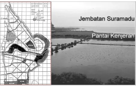
According to the Master Plan of Surabaya Year 2000, the area was planned for open space with mangrove forests, and limited used for fish and shrimp ponds. In order to sustain this condition, the municipal government asked the developers to do the Environmental Impact Study (AMDAL). As a result, the recommendation is 100 to 200 meter of coastal setback line to conserve the mangrove plant, 50-meter river setback line for Wonokromo river and 25-meter for the other smaller rivers (Figure 1). Another study such as transportation study was also carried out. This study tries to look for some access to the area from the western part of the city in order to connect the main road system of the two areas, and to accommodate the eastern outer ring road that passes from the north to the south in the area.
4.3 THE DISTRICT SPATIAL PLAN OF THE EAST COAST OF SURABAYA
Coastal setback line from 100 to 200 meter, and 50-meter river setback line for Wonokromo river and 25-meter for the other smaller rivers,
Providing a flood control system with north-south canal to hold flood from the west side of the area, and 7 percent of the area for retention pond
31 percent of the land for green open space, land use composition for the rest are housing (47%), public facilities (6%), industries (3%), and roads (13%).
Figure 1. The co-production between the Municipal government and the developers for the District Spatial Plan of the East coast of Surabaya (left), and the mangrove of the East coast of
Surabaya (right). Source: The Municipality Government of Surabaya (left), and author (right)
4.4 THE MASTER PLAN: THE ELEMENT OF OPEN SPACE
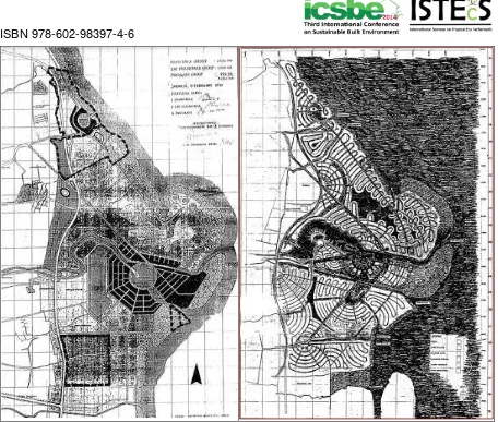
Figure 2. The conceptual Master Plan of the East Coast of Surabaya designed by Paul M. Rudolph (1918-1997) in 1990 (left), and the final Master Plan designed in 1991 (right).
Sources: author.
5. THE BENEFITS OF OPEN SPACE
After six year of development through various stages such as land acquisition, planning, and marketing, in 1996, Pakuwon group developed the first zone of the area at the northern part with an area of 590 hectares. The rest of the area belongs to the two developers can not be fully acquired by them before 2009, consequently they cannot develop it as according to the Surabaya Spatial Plan 2009–2029, the area was planned for natural retention pond. The residential area was developed based a site plan designed by an American consultant that was totally different with the Rudolph‘s master plan due to the market demands. In the Rudolph‘s master plan, inefficient curved and circular road pattern will create irregular shape of lots, and it is difficult to sell irregular shape of lots, as most consumers of high-income groups and Chinese ethnics are unwilling to buy this kind of lots for geomancy reasons (Figure 3). The site plan still has to be confirmed with the District Spatial Plan such as the land use composition, the main streets pattern, and the most important elements of the area the open spaces (31 per cent of open space), such as mangrove coastline of 100 meter wide, parks, the retention ponds and the canals.
boulevards and an outer ring road (Figure 3). The commercial center consists of East Coast Center, an 8-storey retail mall with area of 23,372 square meters with anchored shops, specialty shops and alfresco dining and Soho (shop and home office). The mall was opened in October 22, 2010 (Figure 4).
As mentioned previously, direct benefits of green-space increases property value as many empirical studies have shown that parks have a positive impact (8% to 20%) on nearby residential property values (Harnik, 2009; Circea & Pîrlogea, 2011 ). Most people are willing to pay more for a home close to a green-area, this being reason for an increase in the market value. This was proven in Windsor, Canada where homes of 30 feet from a green-space were valued $6,995 more than those at a mean distance of 1,035 feet (Environment Canada, 1991). In four British Columbia urban communities it was found that a 10% to 15% increase in property value could be attributed to the land‘s proximity to a riparian greenway system (Evergreen, 2009:1).
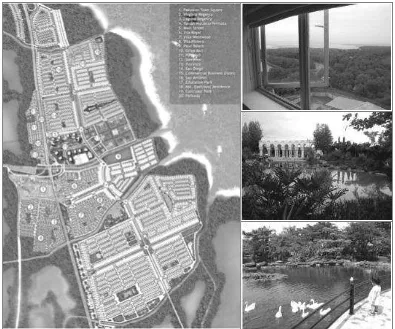
Figure 3. The current site plan showing the developed area coded with numbers (left), and one of the park with retention pond, the Goose Park (top and middle right), and the mangrove along
the coastal line as seen from the window of the East Coast apartment (bottom left). Sources: PT. Pakuwon Jati.
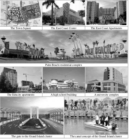
percent per year. This current land price is not only influenced by the open space, but also the provision of amenities in the residential complex, however as shown in the price list of lots, a certain lot close to a park is valued 10 to 20 percent higher than those far from the parks. One popular park with retention pond is Taman Angsa or Goose Park (Figure 3). In 2014, a new residential area has been developed related to the ‗open space as added value‘ such as the Grand Island cluster is developed as a canal resort, a residential complex with water recreation and sports, and the land price of a lot is 21,500,000 per m2 (Figure 4).4
The Town Square The East Coast Center The East Coast Apartments
Palm Beach residential complex
The Educity apartments A high school building A university complex
The gate to the Grand Island cluster The canal concept of the Grand Island cluster
Figure 4. The livable residential areas with public facilities at the Pakuwon City. Source: PT. Pakuwon Jati
3 The land price of the first cluster, Westwood, launced in 1994, and in 2014 the land price of the Palm Beach
Cluster at Pakuwon City as offered by broker, http://rumahdijual.com/surabaya/128227-dijual-tanah-di-palm-beach-malibu-pakuwon-city-surabaya (downloaded on September 14, 2014).
4
6. CONCLUSION
Residential planning is constantly faced with conflicts between pro-development approaches and pro-environment approaches. In the case of the East Coast of Surabaya, especially the Pakuwon City, it can be concluded that the development of the residential area has been developed in line with the environment approach. Following the environment approach, the master plan of the East Coast area was designed based on the various studies such as a hydrology study, a geotechnical study, and an Environmental Impact Study. Subsequently, the residential area was planned with a large open space or 31 percent of the land area for open space namely retention ponds, and green open space (parks and mangrove).
This environment approach is no longer as a constraint but as added value as in this residential area, the green-spaces have economic benefits that increase house or lots prices when green space is present. It is proven that the land price has been increased for more than 30 times since its first launching of the residential area in 1994. Thus, open space has been seen as added value for residential development. Unfortunately, this green space of the high-end residential development in Surabaya is used only for the people who live in the residential complex, except for the Goose Park that located outside the residential cluster.
7. REFERENCES
Ahmed, M.R. & Hassan, R., 2003, People's Perception towards Value of Urban Green space in Environmental Development, Paper submitted to the XII World Forestry Congress, 2003, Canada, Sept 23-30, 2003.
Circea, C. & Pîrlogea, C., 2011, Green Spaces and Public Health in Urban Areas,‘ Theoretical and Empirical Researches in Urban Management, Vol. 6, no. 1, pp. 83-92. Evergreen 2009, Common grounds, Imagine your city with nature, Nature of cities Alberta
Professional Workshop series, http://www.evergreen.ca (date of use: 14 December 2009).
Environment Canada 1991, Community Green space are Worth Money, (Fact Sheet).
Ottawa: Environment Canada, http://www.on.ec.gc.ca/community/greenspace/ intro. html (date of use: 13 December 2009).
Harnik, P. & Welle, B. 2009, Measuring the Economic Value of a City Park System, Philadelphia, Pennsylvania: Trust for Public Land.
Lee, S.L. Prof, et al., 1990, A Feasibility Study on Pantai Timur Project Surabaya: Preliminary Study on Marina No.1, Surabaya: PT. Pakuwon Jati.
Luttik, J. 2000, The value of trees, water and open spaces as reflected by house prices in the Nederlands, in Landscape and Urban Planning, Vol. 48, pp. 161-16.
Pemerintah Kota Surabaya 1991, Rencana Detil Tata Ruang Kota Unit Pengembangan Pantai Timur Surabaya (Detail Spatial Planning for the East Coast of Surabaya District Development), Surabaya: Pemerintah Kotamadya Daerah Tingkat II Surabaya.
Perman, R., MA, Y., McGilvray, J. & Common, M., 2003, Natural Resource and Environmental economics, London: Pearson.