Examining Spatial Effects of Regional Income
Convergence in Sumatra Island
S. Halim1, Inggrid2and I. Bisono1
1
Faculty of Industrial Technology, Industrial Engineering Department, Petra Christian University, Jl. Siwalankerto 121-131 Surabaya 60238, Indonesia;
Email: [email protected], [email protected]
2
Faculty of Economics, Business Management Department, Petra Christian University, Jl. Siwalankerto 121-131 Surabaya 60238, Indonesia;
Email: [email protected]
ABSTRACT
Spatial income disparities have become a central discussion in regional development. This study aims at addressing this issue by examining spatial effects of regional income convergence in Sumatra Island. We also take into account the possible role of the tsunami disaster of 2004 in shaping growth trajectories among provinces in Sumatra. Our results do suggest a persistence income convergence in the island regardless of the onset of the tsunami. The spatial effects indicate a nontrivial spillover effect of the Aceh’s economy on the other provinces only during the pre-disaster period.
Keywords: Spatial effects, regional income convergence, tsunami.
Mathematics Subject Classification: 62P20, 91B62, 91B72
Journal of Economic Literature (JEL) Classification: C11, O47, R12
1. INTRODUCTION
Receding regional income disparity has become a major challenge for the long-term national development agenda. Spatial income inequalities among islands and provinces are the special features of this fact. To date, few studies have been devoted to test convergence and divergence of regional income in Indonesia. The most recent study suggests the presence of convergence in per capita gross regional domestic product (GRDP) during the period 2005-2008. It also highlights the important role of neighborhood effects on convergence processes (Vidyattama, 2013).
In this article, we revisited the income convergence hypothesis across Indonesian provinces. This paper differs from (Vidyattama, 2013) in several important aspects. First, we focus on the convergence process among provinces in Sumatra. The spatial analysis of regional income in Sumatra is an interesting case study because this island has experienced a persistent inter-provincial income inequality as a result of the uneven geographical distribution of natural resources, especially oil and gas. Second, Sumatra which is located in the western part of the Ring of Fire is very susceptible to natural disasters. A notable example is the Indian Ocean tsunami in 2004. It was reported that the disaster caused sizeable economic damages and losses, accounting for
ISSN 0973-1377 (Print), ISSN 0973-7545 (Online) Copyright © 2015 by CESER PUBLICATIONS
approximately 97.4% of Aceh’s GRDP in 2003 (Athukorala, 2005,2012). Hence, we also address the question whether the catastrophic tsunami disaster has a substantial influence on the speed of income convergence among Sumatra regions. Third, we employ the hierarchical modeling for univariate spatial data (Gelfand, 2003; Finley, 2009) allowing for parameter heterogeneity in regional income regressions and spatial economic spillovers among neighboring provinces in Sumatra. From the economic literature, the former contributes to debate on the validity of the traditional Solow growth model (Kourtellos, 2011), whereas the latter points to the advantage of core regions instead of peripheral regions in terms of the rate of growth convergence (Egger and Pfaffermayr, 2006)
The remainder of the paper proceeds in the following way. Section 2 introduces modeling regional income with spatially varying coefficients and gives a brief overview of the data. Section 3 presents and discusses the main findings. The final section summarizes and concludes.
2. METHODS AND DATA
In this section we explore the methods and describe the data set. The methods are summarized particularly from Cressie (1993), Gelfand (2003), and Finley (2009), whereas the used dataset comprises a set of variables that are supposed to be important in the growth accounting model.
2.1. Methods
We model the economic growth rate (ܻ) to follow a univariate Gaussian stationary spatial process as (Cressie, 1993):
ܻሺ࢙ሻ ൌ ߤሺ࢙ሻ ܹሺ࢙ሻ ߝሺ࢙ሻ
where ߤሺ࢙ሻ ൌ ሺ࢙ሻ்ߚ and ߝሺ࢙ሻ is a white noise process, i.e.,
ܧ൫ߝሺ࢙ሻ൯ ൌ Ͳǡ൫ߝሺ࢙ሻ൯ ൌ ߬ଶǡ ሺߝሺ࢙ሻǡ ߝሺ࢙ᇱሻሻ=0, and ܹሺ࢙ሻ is the spatial random effects. ܧ൫ܹሺ࢙ሻ൯ ൌ
Ͳǡ൫ܹሺ࢙ሻ൯ ൌ ߪଶ, ൫ܹሺ࢙ሻǡ ܹሺݏᇱሻ൯ ൌ ߪଶߩሺ࢙ǡ ࢙ᇱǢ ߶ሻǡ where ߩ is a valid two-dimensional correlation
function.
Letߤሺ࢙ሻ ൌ ߚ ߚଵሺ࢙ሻ, write ܹሺ࢙ሻ ൌ ߚሺ࢙ሻ and define ߚ෨ൌߚ ߚሺ࢙ሻ. Then ߚሺ࢙ሻ can be interpreted as a random spatial adjustment at location ࢙to the overall intercept ߚand ߚ෨ can be interpreted as a random intercept process (Gelfand, 2003). In the empirical exercises, we try to assess the possible differences between growth determinants across the provinces within Sumatra Island by using province-specific intercepts.
Moreover, the distribution of ࢼൌ ሺߚሺݏଵሻǡ ǥ ǡ ߚሺݏሻሻ் is derived as ݂ሺࢼȁߪଶǡ ߶ሻ ൌ ܰሺǡ ߪଶܪሺ߶ሻሻ
whereሺܪሺ߶ሻሻൌ ߩ൫ݏെ ݏǢ ߶൯ǡand ߩሺࢎǡ ߶ሻ itself is the Mattern correlation function. ߩሺࢎǡ ߶ሻ ן ሺߛԡࢎԡሻఔȥ
ఔሺߛԡࢎԡሻ
where ȥఔ is a modified Bessel function, ߶ ൌ ሺߛǡ ߥሻ,ߛ is a decay parameter and ߥ is a smoothness parameter.
The Bayesian model is fitted using the marginal likelihood with posterior݂ሺߚǡ ߚଵǡ ߬ଶǡ ߪଶǡ ߶ ȁ࢟ሻ. So that
݂ሺࢼȁ࢟ሻ ൌ න ݂ሺࢼȁߚǡ ߚଵǡ ߬ଶǡ ߪଶǡ ߶ ǡ ࢟ሻ ݂ሺߚǡ ߚଵǡ ߬ଶǡ ߪଶǡ ߶ ȁ࢟ሻ
݂ሺࢼȁߚǡ ߚଵǡ ߬ଶǡ ߪଶǡ ߶ ǡ ࢟ሻ ൌ ܰ ൮൭߬ͳଶߪͳଶܪሺ߶ሻ൱
(see Gelfand, 2003 for a more detailed discussion)
To estimate the above model, we use the R package for the hierarchical modeling for univariate spatial (Finley, 2009).
2.2. Data
We study the regional income convergence for the period 2003-2008 utilizing provincial data sets for all provinces of Sumatra from the Indonesian Central Bureau of Statistics (BPS). To maintain long-term comparability, we merge Kepulauan Riau and Bangka Belitung, the new separated provinces, with their original provinces, Riau and South Sumatera respectively, and this leaves us with 8 provinces. The details of the geographical position of Sumatra Island along with its map are given in Appendix A.
Our main data are the GRDP of provinces in Indonesia by industrial origin and expenditure category at the 2000 constant prices, and the proxy for human capital from the publication of the National Social Economic Survey (SUSENAS). The outcome variable is the growth in per capita GRDP which is calculated as the annual growth rate of GRDP by including the oil and gas sector. As the original Solow model, the covariates are divided into two thematic groups as follows:
1. The measures of convergence, factor accumulation, stabilization policies: the initial GRDP per capita (1995, in logs), the share of capital in GRDP, and the share of government expenditure in GRDP.
2. Human capital: the literacy rate of the population aged 15 and above.
3. RESULTS
Table 1 presents our main findings. We begin our analysis by discussing the evidence of regional income convergence during 2003-2008. Theoretically, there are two concepts of income convergence which are related each other: sigma convergence and beta convergence. Sigma convergence (࣌ െconvergence) occurs when the dispersion of per capita income across provinces declines over time. The second notion is beta convergence (ࢼ െconvergence) which is used in this paper. It suggests that provinces with higher initial income levels grow slowly than provinces with lower income levels or referring to the catching-up effect. At the empirical level, ࢼ െconvergence holds when the relationship between growth in income and its initial level is negative. The results do show the present ofࢼ െconvergence among provinces in Sumatra Island. However, the estimated coefficients vary significantly during the study period, ranging from 0.90% to 14.9% per year. This large variation is probably due to the use of mining GRDP instead of non-mining GRDP, while the production of oil and gas continues to fluctuate throughout the year.
Aceh was remarkably affected (Halim et al., 2013) it could recovered quickly as the rehabilitation and reconstruction of basic socioeconomic infrastructure went well. Moreover, the pattern of the convergence seems to demonstrate the Solow-Swan neo-classical model which predicts temporarily growth in the aftermath of natural disasters.
Table 1. The estimated parameters for growth determinants, 2003-2008
Parameter 2003 2004 2005 2006 2007 2008
Intercept 0.871 -0.304 -1.400 1.610 -0.885 3.160 Initial income -0.149 -0.073 -0.071 -0.009 -0.077 -0.086 Share of government -1.020 -0.315 -0.166 -0.324 -0.325 -0.435 Share of capital -0.192 0.126 -0.095 0.038 0.139 0.556 Literacy rate 0.302 0.860 2.010 -1.590 1.500 -2.710
I
18.500 15.500 16.400 14.700 16.600 14.5002
V
0.238 0.365 0.254 0.219 0.224 0.2502
W
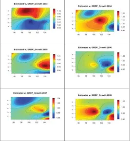
0.256 0.240 0.243 0.234 0.265 0.280The final exercise is to assess whether the neighborhood effect or the spatial effect determines regional income growth of Sumatra. Specifically, we are interested in understanding the role of the Aceh’s economy on the economic performance of its neighboring provinces after experiencing the tsunami of December 2004. The spatial effect of economic growth among provinces in Sumatra is illustrated in Figure 1.
The figure clearly documents a strong spatial effect of income growth in Aceh before the tsunami and this effect is rather weak in the post tsunami period. We interpret this finding as the trivial economic spillovers from Aceh to the rest of Sumatra’s provinces in the aftermath of the catastrophic disaster.
4. DISCUSSION AND CONCLUSION
This paper has attempted to test the income convergence hypothesis and identify the spatial economic effect among provinces in Sumatra. We also give emphasis to the role of the tsunami in 2004 in shaping economic growth of Sumatra Island. The results demonstrate the existence of
ߚ െ
convergence and this continue to hold during the post-tsunami period. The inclusion of the spatial effects in our model confirms that a significant spillover effect of the Aceh’s economy on the other provinces only pertains to the sample before the disaster.5. ACKNOWLEDGEMENT
The authors gratefully acknowledge the generous financial support for this research from the Indonesian Directorate General of Higher Education (DIKTI) under a grant from SP-DIPA-023.04.2.415015/2014.
6. REFERENCES
Athukorala P., 2012, Indian Ocean Tsunami: disaster, generosity, and recovery. Asian Econ J;26, 211-31.
Athukorala P, Resosudarmo BP., 2005, The Indian Ocean Tsunami: economic impact, disaster management, and lessons. Asian Econ Pap,4,1-39.
Cressie N., 1993,Statistics for spatial data. New York: Wiley.
Egger P, Pfaffermayr M., 2006, Spatial convergence. Pap Reg Sci,85,199-215.
Finley AO, Banerjee S., 2009,Exploring Spatial Data in R.
Gelfand AE, Kim H-J, Sirmans CF, Banerjee S., 2003,Spatial modeling with spatially varying coefficient processes. J Am Stat Assoc,98:387–96.
Halim S, Inggrid, Ottemoesoe RDS., 2013,The synthetic regression method: how the Indian Ocean Tsunami affects growth trajectories. Paper was presented at The International Conference on Applied Statistics (ICAS), September 16-19.
Kourtellos A. 2011, Modeling parameter heterogeneity in cross-country regression models. In Beladi O, Choi EK, editors. Frontiers of Economics and Globalization, Bradford: Emerald Group Publishing Ltd; p.367-87.
APPENDIX
Table A. The geographical position of Sumatra Island
Province Capital City Longitude Latitude
Aceh Banda Aceh 95.317 5.550
North Sumatera Medan 98.669 3.592 West Sumatera Padang 100.353 -0.950
Riau Pekanbaru 101.447 0.534
Jambi Jambi 103.610 -1.590
South Sumatera Palembang 104.757 -2.990
Bengkulu Bengkulu 102.262 -3.792
Lampung Bandar Lampung 105.265 -5.448