Issue:
RESIDENTIAL FLOODING
Description of Concern:
While much of Aquidneck Island’s geography lies outside the reach of coastal flooding, some of the region’s most densely populated areas are at risk. Stakeholder discussions revealed concern regarding flooding at the following sites:Newport: The Point, Downtown and the 5th Ward Portsmouth: Melville, Island Park, Common Fence Point Middletown: Atlantic Beach District, Newport Naval Station
A review of the state and municipal hazard mitigation plans revealed that storm surge, coastal flooding and hurricane/nor’easter events represent a significant threat to these areas. In Newport specifically, the threat of flooding along the harbor front poses a threat to many historically significant homes and buildings in residential neighborhoods. The same flood waters that threaten homes also inundate access and evacuation routes, resulting in a significant threat to residents.
Maintaining compliance with regulations and zoning requirements has been seen as a further complication by residents looking for solutions. in economically and socially diverse cities like Newport the threats related to flooding are present for the most vulnerable segments of society as well as those with more financial stability.. Similarly, Island Park, a year-round neighborhood in Portsmouth lies within reach of flood waters and is commonly known as a moderate income neighborhood. Middletown’s residential neighborhoods for the most part are out of the high hazard flood areas.
Residents have begun to take action. The typical solutions for dealing with sea level rise and coastal threats fall under the
categories of protection, accommodation or retreat. Many of these actions can require
difficult and potentially costly decisions to be made by people with strong emotional attachments to their homes. This human element further complicates a complex issue and is faced by a population that covers the spectrum from climate change deniers to vehement environmental activists and everyone in between.
Discussions with a range of Aquidneck Island stakeholders have revealed the following issues and concerns related to the topic of residential flooding:
1) Low-lying areas are already flooding regularly, especially during extreme astronomical (King Tide) events.
2) Preserving the historic integrity of buildings and neighborhoods while adapting them to flooding threats often makes it difficult for property owners to take action.
3) Flood insurance is a complex issue with implications for multiple stakeholder groups.
a. Increasing cost burden as Federal subsidies are reduced b. Though recommended, flood
insurance is not required for older (and potentially more vulnerable structures) that are no longer under a mortgage. c. Lack of public information
available on who has flood insurance and who does not makes management and outreach more difficult
The uncertain future of an indebted Federal Flood Insurance program.
4) Flooding is not always exclusively caused by tidal water; it’s often exacerbated by rainwater and/or aging drainage infrastructure
Background:
Many different governing agencies are involved in addressing residential flooding. When a resident seeks to begin the building permit process, either before or after flooding occurs, they must work with municipal building officials, the Coastal Resources Management Council and the Department of Environmental Management. In addition, the Rhode Island Emergency Management Agency (RIEMA) plays a facilitating role at the municipal level in the Hazard Mitigation planning and the Community Rating System (CRS) in some communities.
Municipal building Officials and state agency officials are well versed in the current codes and regulations and will provide property owners with information on how to ensure they are in compliance. The building code is based on minimum standard to protect life, property and safety. For flood standards, RI Building Code requires that all construction be one foot above the Base Flood Elevation required by the National Flood Insurance Program, and has specific requirements on bringing buildings up to current code.
Often, property owners seeking to build concentrate on how meeting codes will affect the project’s financial bottom line and want to identify how they can get around costly requirements. The tendency to build in a way that focuses on meeting minimum standards can be risky. For example, just because a parcel is outside of a FEMA Special Flood Hazard Area, does not mean it is guaranteed not to experience flooding. Similarly, many property owners do not maintain mandatory flood insurance because of cost or a perceived lack of risk.
Based off geospatial analysis in the Rhode Island Coastal Resources Management Council’s (CRMC’s) STORMTOOLS, Aquidneck Island’s residential communities are located in a range of elevations, some of which are more exposed to coastal flooding than others. The threat of flooding
combined with rising seas serves to quickly amplify the amount of inundation.
Analysis by Rhode Island Statewide Planning indicates that coastal flooding damage to residential property on Aquidneck Island rises dramatically when sea level rise reaches the three foot mark and beyond, a milestone projected to occur by approximately 2065.
Figure 1. Impact of Sea Level Rise alone on Aquidneck Island Residents
(Source: Rhode Island Division of Planning)
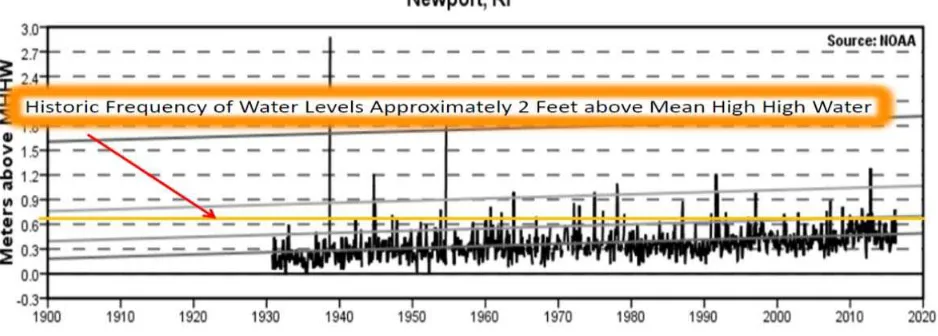
As Aquidneck Island residents know, the coastal waters rarely remain flat and calm. Data from the Newport Tide Gauge reveals that surge events exceeding the mean high water mark have been occurring for some time and appear to be increasing in frequency. Based off historical trends, within the next twenty years residents can expect to see a weather event with two feet of storm surge combine with 1 foot of sea level rise, resulting in a comparable amount of inundation to the SLR predictions for 2065.
Effectively, the variations in amount of sea level rise and storm surge don’t matter if the same amount of flood water is coming. That amount of water has come in the past and can come at any time in the future, not just decades from now.
Figure 3. Number of Exposed Residential E-911 Points by Municipality and Island-wide in 1’SLR Plus a 25 Year Storm and 3’ SLR Plus a 100 Year Storm
1’ SLR + 25 Year Storm 3’ SLR + 100 Year Storm
Middletown 20 32
Newport 696 1,008
Portsmouth 726 1,102
Island
‐
wide
1,442
2,142
(Source: CRMC Rhode Island e911 Exposure Assessment)
The City Newport’s vulnerable population, in combination with the city’s low-lying geography, makes it particularly at risk to rising seas and coastal threats. That being the case, the other municipalities on the Island also have a significant portion of their population with limited means for adaptation to coastal threats. Rising flood insurance costs and the significant expenses involved in either relocating or raising a home significantly limit the potential options for these population segments.
Figure 4. Vulnerable Population Data (source: 2010 census)
Municipality Population With a
disability
In labor force,
Unemployed
Single Mother
w/ children
(0‐18 yrs old)
households
Over 65
living alone
Living
below
poverty
level
Middletown 16,150 1566 744 401 927 1129 Newport 24, 672 2785 821 823 1352 2493 Portsmouth 17,389 2139 721 334 845 1355 Total 58,211 6490 2286 247 3124 4977
There are many resources available for homeowners concerned about flooding on their property:
Newport: William Hanley, Building Official Portsmouth: George Medeiros, Building Official
The Coastal Property Guide developed by the URI Coastal Resources Center and Seagrant provides information for property owners (as well as those looking to purchase coastal property) regarding the conditions that shape Rhode Island’s coastal zone and the policies in place to protect it.
Historic Coastal Communities and Flood Hazard: A Preliminary Evaluation of Impacts to Historic Properties (2015) is a report that is particularly useful for residents in coastal historic properties.
More information on Zoning Ordinances specific to each municipality can be found in: Section F of Article 3 of Portsmouth’s Zoning Ordinance
Article 10 of Chapter 152 of Zoning within the Middletown Town Code Chapter 15.24 of Newport’s Code of Ordinances
The FORTIFIED Home Program by the Insurance Institute for Business & Home Safety (IBHS) is a voluntary program, that aims tostrengthen homes from hurricanes, high winds, hail, and severe thunderstorms by setting criteria for construction standards and methods. CRMC now offers incentives for property owners to use this to reduce their risk.
Recommendations/Potential Actions:
1) Create an “Aquidneck Island Strong” network: a cross sector collaboration that includes non-profit, public and private organizations involved in resilience work to align efforts, share best practices, and leverage resources to advance resilience efforts island-wide.
2) Share lessons learned from experience with Newport and Middletown’s Community Rating System (CRS) program. As a start, review local bylaws and outreach programs to determine how relevant they can be for all Island municipalities and residents.
3) Review Hazard Mitigation Plan actions related to residential neighborhoods to determine priority actions to reduce risk.
4) Incorporate vulnerable population data and analysis into municipal, regional and state hazard mitigation plans with the help of social service providers so that vulnerable populations are clearly identified and represented at all levels of hazard mitigation planning.
5) Engage private landowners as well as renters with different approaches to implement that reduce flood hazards.
6) Carry out an information sharing campaign for property owners on flooding and climate change related property threats targeted towards community and neighborhood associations.
7) Invest in education and outreach for surveyors and builders to increase literacy regarding flood and climate change science and management practices.
8) Evaluate the option to have a coordinate warning through Code Red to residents in vulnerable neighborhoods for flooding events, including extreme tides, heavy rain events, and storms 9) Collaborate on grants and partnerships for mitigating risks, such as residential rain gardens or