Date: 2007-07-17
Reference number of this document: OGC® 07-000
Version: 1.0.0
Category: OpenGIS® Implementation Specification
Editor: Mike Botts Co-Editor: Alexandre Robin University of Alabama in Huntsville
OpenGIS
®Sensor Model Language (SensorML)
Implementation Specification
Copyright © 2007 Open Geospatial Consortium, Inc. All Rights Reserved.
To obtain additional rights of use, visit http://www.opengeospatial.org/legal/
Recipients of this document are invited to submit, with their comments, notification of any relevant patent rights of which they are aware and to provide supporting
documentation.
Document type: OpenGIS® Publicly Available Standard Document subtype: Implementation Specification
ii Copyright © 2012 Open Geospatial Consortium License Agreement
Permission is hereby granted by the Open Geospatial Consortium, ("Licensor"), free of charge and subject to the terms set forth below, to any person obtaining a copy of this Intellectual Property and any associated documentation, to deal in the Intellectual Property without restriction (except as set forth below), including without limitation the rights to implement, use, copy, modify, merge, publish, distribute, and/or sublicense copies of the Intellectual Property, and to permit persons to whom the Intellectual Property is furnished to do so, provided that all copyright notices on the intellectual property are retained intact and that each person to whom the Intellectual Property is furnished agrees to the terms of this Agreement.
If you modify the Intellectual Property, all copies of the modified Intellectual Property must include, in addition to the above copyright notice, a notice that the Intellectual Property includes modifications that have not been approved or adopted by LICENSOR. THIS LICENSE IS A COPYRIGHT LICENSE ONLY, AND DOES NOT CONVEY ANY RIGHTS UNDER ANY PATENTS THAT MAY BE IN FORCE ANYWHERE IN THE WORLD.
THE INTELLECTUAL PROPERTY IS PROVIDED "AS IS", WITHOUT WARRANTY OF ANY KIND, EXPRESS OR IMPLIED, INCLUDING BUT NOT LIMITED TO THE WARRANTIES OF MERCHANTABILITY, FITNESS FOR A PARTICULAR PURPOSE, AND NONINFRINGEMENT OF THIRD PARTY RIGHTS. THE COPYRIGHT HOLDER OR HOLDERS INCLUDED IN THIS NOTICE DO NOT WARRANT THAT THE FUNCTIONS CONTAINED IN THE INTELLECTUAL PROPERTY WILL MEET YOUR REQUIREMENTS OR THAT THE OPERATION OF THE INTELLECTUAL PROPERTY WILL BE UNINTERRUPTED OR ERROR FREE. ANY USE OF THE INTELLECTUAL PROPERTY SHALL BE MADE ENTIRELY AT THE USER’S OWN RISK. IN NO EVENT SHALL THE COPYRIGHT HOLDER OR ANY CONTRIBUTOR OF INTELLECTUAL PROPERTY RIGHTS TO THE INTELLECTUAL PROPERTY BE LIABLE FOR ANY CLAIM, OR ANY DIRECT, SPECIAL, INDIRECT OR CONSEQUENTIAL DAMAGES, OR ANY DAMAGES WHATSOEVER RESULTING FROM ANY ALLEGED INFRINGEMENT OR ANY LOSS OF USE, DATA OR PROFITS, WHETHER IN AN ACTION OF CONTRACT, NEGLIGENCE OR UNDER ANY OTHER LEGAL THEORY, ARISING OUT OF OR IN CONNECTION WITH THE IMPLEMENTATION, USE, COMMERCIALIZATION OR PERFORMANCE OF THIS INTELLECTUAL PROPERTY. This license is effective until terminated. You may terminate it at any time by destroying the Intellectual Property together with all copies in any form. The license will also terminate if you fail to comply with any term or condition of this Agreement. Except as provided in the following sentence, no such termination of this license shall require the termination of any third party end-user sublicense to the Intellectual Property which is in force as of the date of notice of such termination. In addition, should the Intellectual Property, or the operation of the Intellectual Property, infringe, or in LICENSOR’s sole opinion be likely to infringe, any patent, copyright, trademark or other right of a third party, you agree that LICENSOR, in its sole discretion, may terminate this license without any compensation or liability to you, your licensees or any other party. You agree upon termination of any kind to destroy or cause to be destroyed the Intellectual Property together with all copies in any form, whether held by you or by any third party. Except as contained in this notice, the name of LICENSOR or of any other holder of a copyright in all or part of the Intellectual Property shall not be used in advertising or otherwise to promote the sale, use or other dealings in this Intellectual Property without prior written authorization of LICENSOR or such copyright holder. LICENSOR is and shall at all times be the sole entity that may authorize you or any third party to use certification marks, trademarks or other special designations to indicate compliance with any LICENSOR standards or specifications.
This Agreement is governed by the laws of the Commonwealth of Massachusetts. The application to this Agreement of the United Nations Convention on Contracts for the International Sale of Goods is hereby expressly excluded. In the event any provision of this Agreement shall be deemed unenforceable, void or invalid, such provision shall be modified so as to make it valid and enforceable, and as so modified the entire Agreement shall remain in full force and effect. No decision, action or inaction by LICENSOR shall be construed to be a waiver of any rights or remedies available to it.
Table of Contents
i. Preface... viii
ii. Document Terms and Definitions... viii
iii. Submitting Organizations ... viii
iv. Submission Contact Point ... ix
v. Revision History ... ix
vi. Recommended Changes to the OpenGIS Abstract Specification... x
vii. Future Work... x
Foreword... xii
Introduction... xiii
1 Scope... 15
2 Conformance ... 18
3 Normative references... 18
4 Terms and definitions ... 20
5 Conventions ... 23
5.1 Symbols (and abbreviated terms)... 23
5.2 UML Notation... 25
6 Background ... 27
6.1 Motivation... 27
6.2 Importance to archival needs ... 28
6.3 Importance to software support ... 29
6.4 Importance to Sensor Web Enablement... 30
7 Design Criteria and Assumptions for SensorML... 32
7.1 Basic definition of a sensor... 32
7.2 Applications of SensorML... 32
7.3 Sensor aggregation concepts... 33
7.4 Relationship of the sensor to a platform ... 33
7.5 Coordinate reference systems ... 35
7.6 Measurement / observation concepts ... 36
7.7 Sensor response characteristics... 36
7.8 Sample and collection geometry concepts... 36
8 SWE Common Conceptual Models... 38
8.1 Simple Data Types... 38
8.1.1 DataComponents... 39
8.1.2 Boolean ... 40
8.1.3 Category... 40
8.1.4 Text ... 40
8.1.5 Numerical data types... 40
8.1.6 Quantity and QuantityRange... 40
8.1.7 Count and CountRange ... 41
8.1.8 Time and TimeRange... 41
8.1.9 Union Types... 41
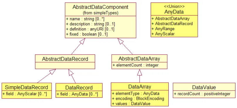
8.2 Aggregate Data Types... 41
8.2.1 Generic Aggregates... 42
8.2.2 Specialized Aggregates... 44
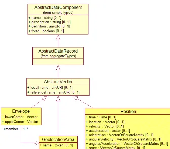
8.3 Position Data... 44
8.3.1 Position ... 45
8.3.2 Envelope, GeoLocationArea... 46
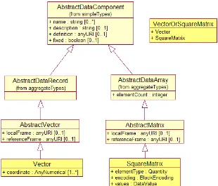
8.3.3 Vector... 46
8.3.4 SquareMatrix... 47
8.4 Temporal Aggregates... 47
8.4.1 Scope... 47
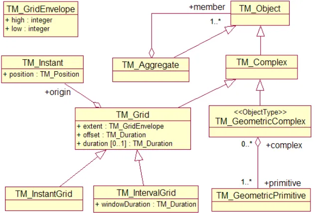
8.4.2 TM_Aggregate... 48
8.4.3 TM_GeometricComplex ... 48
8.4.4 TM_Grid, TM_InstantGrid, TM_IntervalGrid ... 48
8.5 Encoding ... 49
8.5.1 TextBlock... 49
8.5.2 BinaryBlock ... 50
8.5.3 StandardFormat... 50
8.5.4 MultiplexedStreamFormat ... 50
8.5.5 XMLBlock ... 50
8.6 Phenomenon... 51
8.6.1 Scope... 51
8.6.2 Derived Phenomenon... 52
8.6.3 Concrete Phenomenon classes ... 52
8.7 ObservableProperty... 53
SensorML Conceptual Models... 54
8.8 ProcessType ... 54
8.9 Non-physical (or pure) processes... 56
8.9.1 ProcessModel... 57
8.9.2 ProcessMethod... 57
8.9.3 ProcessChain... 57
8.10 Physical Processes ... 58
8.10.1 Component... 60
8.10.2 System... 60
8.11 Process Metadata Group ... 61
8.11.1 General Information (Identifier and Classifier) ... 61
8.11.2 Constraints ... 62
8.11.3 Properties (Capabilities and Characteristics) ... 62
8.11.4 References (Contacts and Documentation)... 63
8.11.5 History... 63
8.12 SensorML as Applied to Sensors... 64
8.12.1 Sensor Response and Geolocation ... 64
8.12.2 Observations and Data Encoding... 64
8.12.3 Sensor Response Model... 65
8.12.4 Sensor Models... 65
9 SWE Common XML Encoding and Examples (Informative) ... 66
9.1 Encoding principles ... 66
9.1.1 XML Encoding Conventions ... 66
9.1.2 ID, URI, and Linkable Properties ... 67
9.2 SWE Common Data... 68
9.2.1 Simple data components (hard-typing and soft-typing)... 68
9.2.2 Simple data types ... 68
9.2.3 ObservableProperty... 71
9.2.4 Data Aggregates... 71
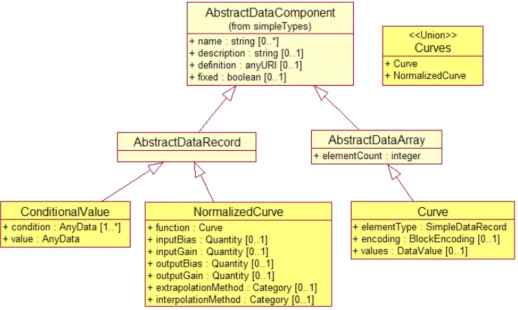
9.2.5 Curves ... 76
9.2.6 TimeAggregates... 77
9.2.7 Phenomenon... 77
10 SensorML XML Encodings and Examples (Informative) ... 80
10.1 ProcessModel (Atomic Non-Physical Process) ... 80
10.1.1 ProcessMethod... 81
10.2 Component (Atomic Physical Process) ... 83
10.3 ProcessChain (Composite Non-Physical Process)... 87
10.4 System (Composite Physical Process) ... 91
10.5 Metadata Group ... 102
10.5.1 Keywords, Identification, and Classification... 103
10.5.2 Constraints ... 104
10.5.3 Characteristics and Capabilities... 104
10.5.4 References... 106
10.5.5 History... 106
10.6 SensorML Profiles ... 107
11 Future Directions and Remaining Issues... 108
Annex A. XML Schemas for SensorML (normative) ... 109
A.1 base.xsd... 109
A.2 process.xsd. ... 117
A.3 method.xsd. ... 123
A.4 system.xsd... 126
A.5 sensorML.xsd... 132
Annex B. XML Schemas for SWE Common (normative) ... 133
B.1 swe.xsd... 133
B.2 basicTypes.xsd. ... 133
B.3 simpleTypes.xsd... 138
B.4 aggregateTypes.xsd... 150
B.5 data.xsd. ... 155
B.6 encoding.xsd. ... 156
B.7 curveTypes.xsd ... 159
B.8 positionTypes.xsd. ... 160
B.9 temporalAggregates.xsd... 163
B.10 phenomenon.xsd. ... 168
B.11 xmlData.xsd. ... 172
Annex C. Annex C: Model for Detector (Informative) ... 174
Annex D: History of SensorML (Informative)... 177
References... 180
i. Preface
The primary focus of SensorML is to define processes and processing components associated with the measurement and post-measurement transformation of observations. This specification is one of five engineering specifications produced under OGC’s Sensor Web Enablement (SWE) activity, which is being executed under OGC’s Interoperability Program. The initial version was produced during OGC Web Services (OWS) 1.1 Initiative, conducted in 2001. The previous version was produced under the OGC Web Services (OWS) 3.0 Initiative, conducted March 2005 - October 2005. This version is in response to recommendations during the Release for Public Comment (April – August 2006), as well as efforts that have been continued since the OWS 3 initiatives and during the OWS 4 Initiative, conducted May 2006 – December 2006. This document provides version 1.0 of the SensorML core specification and supersedes all previous document versions including 05-086r3.
ii.
Document Terms and Definitions
This document uses the specification terms defined in Subclause 5.3 of [OGC 05-008], which is based on the ISO/IEC Directives, Part 2. Rules for the structure and drafting of International Standards. In particular, the word “shall” (not “must”) is the verb form used to indicate a requirement to be strictly followed to conform to this specification.
iii. Submitting
Organizations
The following organizations submitted this document to the Open Geospatial Consortium, Inc:
a. University of Alabama in Huntsville
b. Commonwealth Scientific and Industrial Research Organisation (CSIRO) Australia
c. IRIS Corporation d. Distributed Instruments e. Galdos Systems, Inc f. Image Matters, LLC g. SeiCorp, Inc.
iv.
Submission Contact Point
All questions regarding this document should be directed to the editor or the contributors:
CONTACT COMPANY ADDRESS
Mike Botts (Editor) University of Alabama in Huntsville
ESSC / NSSTC Huntsville, AL 35899
Alexandre Robin University of Alabama in Huntsville
ESSC / NSSTC Huntsville, AL 35899
Simon Cox CSIRO, Australia PO Box 1130, Bentley WA 6102 Australia
Steve Havens IRIS Corporation 4220 Varsity Drive Suite E Ann Arbor, MI 48108
Jeff Ricker Distributed Instruments 33 West Shore Drive Putnam Valley, NY 10579
Ron Lake Galdos Systems, Inc. Suite 200, 115 West Pender Street, Vancouver, B.C. V6E 2P4
Harry Niedzwiadek Image Matters, LLC 214 South King St. Leesburg VA 20175
Bill Craig SeiCorp, Inc. 5870 Trinity Parkway, Suite 350 Centreville, VA 20120-1970
v. Revision
History
Date Release Author Section modified Description
2006-06-01 05-086r3 meb Version 0.0, approved in July 2006
2007-01-10 07-000 bc throughout Extensive editorial corrections
2007-01-10 07-000 meb, ar throughout Reflects several changes to the schema based on recommendations during the RFC process:
(1) derivation from GML 3.1.1,
(2) modifications to SWE Common data types to better reflect ISO data models,
(3) better separation of physical and non-physical processes
2007-03-02 07-000 sc, meb 8.4, 8.6, 10.2.6, 10.2.7
Added models and examples for Time Aggregates and Phenomenon
2007-03-02 07-000 meb 8.7, 10.2.3 Added ObservableProperty as by-reference only simple type for measureably properties of Phenomenon or ontologies
2007-03-02 07-000 meb throughout Reorganized sections, splitting SWE Common sections from SensorML sections
2007-03-06 07-000 meb, body,
reynolds throughout General editing
2007-03-30 07-000 meb, sc 8.0 Revised UML models for SWE Common
2007-05-04 07-000 meb throughout Replaced “role” attribute with “arcrole”
2007-05-04 07-000 meb 9.2.5 corrected the curve example
2007-07-17 07-000 meb throughout corrected URNs in examples to reflect current design
Any issues in this specification are captured in the following format:
Issue Name: [Issue Name goes here. (Your Initials, Date)]
Issue Description: [Issue Description.]
Resolution: [Insert Resolution Details and History.] (Your Initials, Date)]
vi.
Recommended Changes to the OpenGIS Abstract Specification
It is recommended that OGC Abstract Specifications dealing with spatial referencing (e.g. OGC Topic 1 – ISO 19107) be revisited to provide more robust definitions of location, position, orientation, coordinate system, and coordinate reference system. The current definitions are heavily “point-biased” rather than “body-bias”. Precise
georeferencing of sensor observations requires the potential disclosure of the full state of a body, including location and orientation, as well as possibly velocity, acceleration, angular velocity, and angular acceleration. The current definitions of coordinate systems in these specifications ignore the role of the Coordinate System (CS) axes in supporting rotations. Furthermore, the definition of coordinate reference system depends on a “datum” yet the definition of a datum is not provided.
In addition, the robust georeferencing of sensor observations depends on the ability to robustly specify the dynamic state of one body to another (e.g. the state of a sensor to its platform, or to other sensors). The concepts for Coordinate Reference Systems (CRS) within the Abstract Specifications have been derived first to support geodetic coordinates and datums, with engineering or local CRSes being defined relative to these. It is
recommended that CRS definitions and concepts begin with more general mathematical principals for axes and coordinate systems, and that the definitions for geodetic CRSes be defined as a specialization of general principals. Furthermore, it is recognized that a robust specification of one body to another (or to a geodetic CRS) requires that one first define a local CRS for the local object and that the state of the local object is thus defined by relating the local CRS to the external CRS. These principals are not considered in the current Abstract Specifications.
vii. Future
Work
In future versions of this work, it is planned to:
1. make the UML conformant with ISO 19103, ISO 19118 and ISO 19136 Annex E 2. harmonize between the SWE Common datatypes model and ISO 19103 and ISO
19123
3. harmonize between SensorML and the sensor model to be defined in ISO 19130
4. refactor the “SWE Common” components into a separate document
5. invesitigate harmonization between SensorML and OGC Web Processing Service (WPS)
6. harmonize between SensorML and TransducerML
7. further harmonization of metadata with ISO 19115 and 19139
8. harmonize between SensorML event/history with ISO 19108 and 19109 9. harmonize between SensorML and the Abstract Specification documents for
spatial positioning
Foreword
This specification originated under NASA Advanced Information Systems Technology (AIST) funding and has been further advanced under the OGC OWS 1.1, OWS 1.2, OWS 3, and OWS 4 initiatives, and through separate funding from the National Geospatial-Intelligence Agency, Northrop Grumman Corporation TASC, Defense Intelligence Agency, NASA, European Space Agency, and SAIC.
Additional information is available at http://vast.uah.edu/SensorML. In addition, one can subscribe to the SensorML forum and listserver at:
http://mail.opengeospatial.org/mailman/listinfo/sensorML.
This document includes four annexes; Annexes A and B are normative, while Annexes C and D are informative.
Attention is drawn to the possibility that some of the elements of this document may be the subject of patent rights. The OGC shall not be held responsible for identifying any or all such patent rights.
Introduction
The Open Geospatial Consortium (OGC) Sensor Web Enablement (SWE) activity, is being executed through the OGC Web Services (OWS) initiatives (under the
Interoperability Program). The SWE initiatives are establishing the interfaces and protocols that will enable a “Sensor Web” through which applications and services will be able to access sensors of all types over the Web. These initiatives have defined, prototyped and tested several foundational components needed for Sensor Web Enablement, namely:
1. Sensor Model Language (SensorML) – The general models and XML encodings for sensors and observation processing. SensorML originated under OWS 1.1, was significantly enhanced under OWS 1.2, OWS 3, and OWS 4 Initiatives.
2. Observations & Measurements (O&M) - The general models and XML encodings for sensor observations and measurements. O&M originated under OWS 1.1 and was significantly enhanced under OWS 1.2, OWS 3, and OWS 4.
3. TransducerML (TML) – A model and encoding for streaming
multiplexed data from a sensor system, and for describing the system and data encoding. Developed initially by the IRIS Corporation, this service is being brought into the OGC SWE framework and has undergone further development as part of the OWS 3 and OWS 4 Initiatives.
4. Sensor Observation Service (SOS) – A service by which a client can obtain observations from one or more sensors/platforms (can be of mixed sensor/platform types). Clients can also obtain information that describes the associated sensors and processes. This service originated under OWS 1.1 and was significantly enhanced under OWS 1.2, OWS 2, OWS 3, and OWS4.
5. Sensor Planning Service (SPS) – A service by which a client can determine collection feasibility for a desired set of collection requests for one or more mobile sensors/platforms, or a client may submit collection requests directly to these sensors/platforms. This service was defined under OWS 1.2 and enhanced under OWS 3 and OWS 4.
6. Sensor Alert Service (SAS) – A service for advertising, subscribing to, and publishing alerts to alert listener clients. This service is being defined under the Sensor Alert Service Interoperability Experiment and enhanced under the OWS 4 Initiative.
7. Web Notification Service (WNS) – A service by which a client may conduct asynchronous dialogues (message interchanges) with one or more other services. This service is useful when many collaborating services are
required to satisfy a client request, and/or when significant delays are involved is satisfying the request. This service was defined under OWS 1.2 in support of SPS operations. WNS has broad applicability in many such multi-service applications.
This document specifies SensorML, as well as several SWE Common data components utilized throughout the SWE framework. The other SWE encodings and web services components are specified under separate documents.
While SensorML serves as a component within the OGC Sensor Web Enablement
framework, SensorML does not depend upon the presence of the other SWE components. It is envisioned that SensorML will be utilized both as part of, and independent of, the OGC Sensor Web Enablement framework.
Sensor Model Language: An Implementation Specification
1
Scope
This document specifies models and XML encoding for the core SensorML, as well as the definition of several SWE Common data components utilized throughout the SWE framework. The primary focus of SensorML is to define processes and processing components associated with the measurement and post-measurement transformation of observations.
The purposes of SensorML are to:
• Provide descriptions of sensors and sensor systems for inventory management
• Provide sensor and process information in support of resource and observation discovery
• Support the processing and analysis of the sensor observations
• Support the geolocation of observed values (measured data)
• Provide performance characteristics (e.g., accuracy, threshold, etc.)
• Provide an explicit description of the process by which an observation was obtained (i.e., it’s lineage)
• Provide an executable process chain for deriving new data products on demand (i.e., derivable observation)
• Archive fundamental properties and assumptions regarding sensor systems
SensorML provides a common framework for any process and process chain, but is particularly well-suited for the description of sensor and systems and the processing of sensor observations. Within SensorML, sensors and transducer components (detectors, transmitters, actuators, and filters) are all modeled as processes that can be connected and participate equally within a process chain or system, and which utilize the same process model frame as any other process.
Processes are entities that take one or more inputs and through the application of well-defined methods using specific parameters, results in one or more outputs. The process model defined in SensorML can be used to describe a wide variety of processes,
including actuators, spatial transforms, and data processes, to name a few. SensorML also supports linking between processes and thus supports the concept of process chains, which are themselves defined as processes.
SensorML provides a framework within which the geometric, dynamic, and observational characteristics of sensors and sensor systems can be defined. There are a great variety of sensor types, from simple visual thermometers to complex electron microscopes and earth observing satellites. These can all be supported through the definition of atomic process models and process chains.
The models and schema within the core SensorML definition (i.e., within this document) provide a “skeletal” framework for describing processes, process chains, and sensor
systems. In order to achieve interoperability within and between various sensor communities, implementation of SensorML will require the definition of community-specific semantics (within online dictionaries or ontologies) that can be utilized within the framework. In addition, we envision the development of small, general-use, atomic processes that can serve as components within process chains. This will include a general model and XML profile to be used for defining most if not all detectors, actuators, and filters within a sensor system, as well as general process definitions for fundamental spatial transforms and basic signal processing components. These can also include more specific models used within the remote sensing community, for example, including rigorous and polynomial sensor geolocation models.
Within SensorML, all processes and components are encoded as application schema of the Feature model in the Geographic Markup Language (GML) Version 3.1.1.
With regard to Observations and Measurements, we assume four fundamental components of information:
1. There are properties of physical entities and phenomena that are capable of being measured and quantified. Within the SWE context, a property that is capable of being measured is considered as an “ObservableProperty” or “Phenomenon”. Each of these can be referenced in an online dictionary or ontology. Such definitions might include, for example, properties such as temperature, count, rock type, chemical concentration, or radiation emissivity. Within SensorML, such definitions will typically be referenced through URIs (particularly URNs). 2. There are sensors that are capable of observing and measuring particular
properties. Either by design or as a result of operational conditions, these sensors have particular response characteristics that can be used to determine the values of the measurements, as well as to assess the quality of these measurements. In addition to the response characteristics, these sensor systems have properties of location and orientation that allow one to associate the measured values with a particular geospatial location at a particular time. The role of the SensorML is to provide characteristics required for processing, georegistering, and assessing the quality of measurements from sensor systems.
Within this context, SensorML documents can serve two possible roles. The first is to describe the procedure by which an existing observation was obtained. This would include the sensor measurement process, as well as any post processing of the raw observations. The second possible role is to provide processing chains with which SensorML-enabled software could derive new data from existing observations on-demand. One might consider this as a “Derivable Observation”, since the values don’t exist prior to execution of the processing chain.
3. Finally, there are data values that are returned by a sensor system or are derived from sensor measurements. These measurements may be accessed directly from the sensor, or from caches or data stores that distribute and possibly process these data into various products. The processing and georegistration of these measured values require knowledge of the properties of the sensor system. Within the context of the OGC Sensor Web Enablement framework, values returned by
sensors can be provided within the Observations and Measurements schemas or other data provider types.
Within the Observation model provided by the Observations and Measurements schema, a procedure describes the processes of measurement and
post-measurement processing that resulted in the observation. This procedure can be encoded within SensorML and can be referenced using the procedure property of an Observation. Furthermore, a sensor can observe one or more features of interest during a given observation event; these features can be defined with the
featureOfInterest property of an Observation. The location of these features, which may perhaps include a swath of the earth’s surface observed by a remote sensor, can be provided by a SensorML process.
All three of these components are linked within the Sensor Web Enablement concepts. While these links will be discussed within this document, only the second component is within the scope of this document.
SensorML can, but generally does not, provide a detailed description of the hardware design of a sensor. Rather it is a general schema for describing functional models of the sensor. The schema is designed such that it can be used to support the processing and geolocation of data from virtually any sensor, whether mobile or dynamic, in-situ or remotely sensed, or active or passive. This allows one to develop general, yet robust, software that can process and geolocate data from a wide variety of sensors, ranging from simple to complex sensor systems.
SensorML enables robust definitions of sensor models for providing geolocation of observations from remote sensors. SensorML supports both rigorous geolocation models and mathematical geolocation models. A rigorous sensor model is defined here as one that describes the geometry and physical dynamics of the instrument and provides the ability to utilize this information along with position and orientation of the platform in order to derive geolocation of the sensor data. Mathematical sensor models are typically derived using a rigorous model, perhaps augmented by human interaction. These general mathematical models typically hide the physical characteristics of the sensor and allow for geolocation of sensor data through the use of polynomial functions. Different mathematical models can be designed to define a sample location within a variety of coordinate systems, including the local sensor frame, the local frame for the associated platform, or a geographic coordinate reference frame.
Within SensorML, one may choose to model a sensor platform as a system, with its own Coordinate Reference System, to which on-board sensor positions can be referenced. One may also choose to provide relative positions between various sensors while ignoring the platform reference frame, by defining any sensor position relative to an onboard GPS sensor and an orientation (gimbal) sensor. Either way, for the case of rigorous sensor models, we allow one to separate the description of the sensor from that of its platform. Common platforms include: ground stations, automobiles, aircraft, earth-orbiting satellites, ocean buoys, ships, and people. A deployed sensor is mounted on a static or dynamic platform (or an assembly of nested platforms).
There are several data component definitions that were previously defined jointly within the SensorML and O&M specifications. These common components are utilized
throughout the SWE encodings and web services. For this reason, these have been separated from the SensorML namespace (namespace prefix: “sml”), and have been defined within a “SWE Common” namespace (namespace prefix: “swe”). These are defined within the current document, although it is anticipated that the definition (but not the use) of the SWE Common components will be removed from future versions of SensorML and will instead be defined in a separate document.
2 Conformance
Conformance and Interoperability Testing for SensorML may be checked using all the relevant tests that pertain to Annex A (normative). The framework, concepts, and methodology for testing, and the criteria to be achieved to claim conformance are specified in ISO 19105: Geographic information — Conformance and Testing.
3 Normative
references
The following normative documents contain provisions, which through reference in this text, constitute provisions of this document. For dated references, subsequent
amendments to, or revisions of, any of these publications do not apply. However, parties to agreements based on this document are encouraged to investigate the possibility of applying the most recent editions of the normative documents indicated below. For undated references, the latest edition of the normative document referred to applies.
IETF RFC 2396, Uniform Resource Identifiers (URI): Generic Syntax. (August 1998)
ISO 8601:2004, Data elements and interchange formats — Information interchange Representation of dates and times
ISO/IEC 11404:1996, Information technology — Programming languages, their environments and system software interfaces – Language-independent datatypes ISO 19101:2002, Geographic Information--ReferenceModel
ISO/TS 19103:2005, Geographic Information — Conceptual schema language
ISO 19107:2003, Geographic Information — Spatial schema
ISO 19108:2002, Geographic Information — Temporal schema
ISO 19109:2005, Geographic Information — Rules for application schemas
ISO 19115:2003, Geographic Information — Metadata
ISO 19118:2005, Geographic Information — Encoding
ISO 19123:2005, Geographic Information — Coverages
ISO FDIS 19136:2006, Geographic Information — Geography Markup Language
ISO FDTS 19139:2006, Geographic Information — Metadata — XML schema Implementation
IETF RFC 2396, Uniform Resource Identifiers (URI): Generic Syntax. (August 1998)
OpenGIS® Implementation Specification Filter Encoding version 1.1. OGC Document
04-095 http://www.opengeospatial.org/
OpenGIS® Implementation Specification Geography Markup Language, version 3.2.
OGC Document 06-XXX http://www.opengeospatial.org/
OpenGIS® Abstract Specification Observations and Measurements – Part 1: Observation Schema, OGC document 07-022.
UCUM, Unified Code for Units of Measure, Schadow, G. and McDonald, C. J. (eds.),
http://aurora.rg.iupui.edu/UCUM
W3C XLink, XML Linking Language (XLink) Version 1.0. W3C Recommendation (27 June 2001)
W3C XML, Extensible Markup Language (XML) 1.0 (Second Edition), W3C Recommendation (6 October 2000)
W3C XML Namespaces, Namespaces in XML. W3C Recommendation (14 January 1999)
W3C XML Schema Part 1, XML Schema Part 1: Structures. W3C Recommendation (2 May 2001)
W3C XML Schema Part 2, XML Schema Part 2: Datatypes. W3C Recommendation (2 May 2001)
4
Terms and definitions
For the purposes of this document, the following terms and definitions apply.
4.1 Actuator
A type of transducer that is a simple element that converts a signal to some action or real world phenomenon. In SensorML a actuator is a particular type of Process Model.
4.2 Coordinate Reference System (CRS)
A spatial or temporal framework within which a position and/or time can be defined. According to ISO 19111, a coordinate system that is related to the real world by a datum.
4.3 Coordinate System (CS)
According to ISO19111, a set of (mathematical) rules for specifying how coordinates are assigned to points. In this document, a Coordinate System is extended to be defined as a set of axes with which location and orientation can be defined.
4.4 Datum
Undefined in ISO 19111. Defined here as a means of relating a coordinate system to the real world by specifying the physical location of the coordinate system and the orientation of the axes relative to the physical object. For a geodetic datum, the definition also includes a reference ellipsoid that approximate the surface of the planetary body.
4.5 Detector
Atomic part of a composite MeasurementSystemdefining sampling and response characteristic of a simple detection device. A detector has only one input and one output, both being scalar quantities. More complex Sensors, such as a frame camera, which are composed of multiple detectors can be described as a detector group or array using a System or Sensor. In SensorML a detector is a particular type of Process Model.
4.6 Determinand
A Parameter or a characteristic of a phenomenon subject to observation. Synonym for
observable. [O&M]
4.7 Location
A point or extent in space relative to a coordinate system. For point-based systems, this is typical expressed as a set of n-dimensional coordinates within the coordinate system. For bodies, this is typically expressed by relating the translation of the origin of an object’s local coordinate system
with respect to the origin of an external reference coordinate system.
4.8 Location Model
A model that allows one to locate objects in one local reference frame relative to another
reference frame.
4.9 Measurand
Physical parameter or a characteristic of a phenomenon subject to a measurement, whose value is described using a Measure (ISO 19103). Subset of determinand or observable. [O&M]
4.10 Measure (noun)
Value described using a numeric amount with a scale or using a scalar reference system
[ISO/TS 19103]
. When used as a noun, measure is a synonym for physical quantity.
4.11 Measurement (noun)
An observation whose result is a measure[O&M]
4.12 Measurement (verb)
An instance of a procedure to estimate the value of a natural phenomenon, typically involving an instrument or sensor. This is implemented as a dynamic feature type, which has a property containing the result of the measurement. The measurement feature also has a location, time, and reference to the method used to determine the value. A measurement feature effectively binds a value to a location and to a method or instrument.
4.13 Observable, Observable Property (noun)
A parameter or a characteristic of a phenomenon subject to observation. Synonym for
determinand. [O&M]
4.14 Observation (noun)
An act of observing a property or phenomenon, with the goal of producing an estimate of the value of the property. A specialized event whose result is a data value. [O&M]
4.15 Observed Value
A value describing a natural phenomenon, which may use one of a variety of scales including
nominal, ordinal, ratio and interval. The term is used regardless of whether the value is due to an instrumental observation, a subjective assignment or some other method of estimation or
assignment. [O&M]
4.16 Orientation
The rotational relationship of an object relative to a coordinate system. Typically expressed by relating the rotation of an object’s local coordinate system relative to an external reference coordinate system.
4.17 Phenomenon
A physical property that can be observed and measured, such as temperature, gravity, chemical concentration, orientation, number-of-individuals.
A characteristic of one or more feature types, the value for which must be estimated by application of some procedure in an observation.
4.18 Position
The location and orientation of an object relative to a coordinate system. For body-based systems (in lieu of point-based systems) is typically expressed by relating the object’s local coordinate system to an external reference coordinate system. This definition is in contrast to some definitions (e.g. ISO 19107) which equate position to location.
4.19 Process
A process that takes one or more inputs, and based on parameters and methodologies, generates one or more outputs.
4.20 Process Method
Definition of the behavior and interface of a Process. It can be stored in a library so that it can be reused by different Process instances (by using ‘xlink’ mechanism). It essentially describes the process interface and algorithm, and can point the user to existing implementations.
4.21 Process Chain
Composite processing block consisting of interconnected sub-processes, which can in turn be
Process Models or Process Chains. A process chain also includes possible data sources as well
as connections that explicitly link input and output signals of sub-processes together. It also precisely defines its own inputs, outputs and parameters.
4.22 Reference Frame
A coordinate system by which the position (location and orientation) of an object can be referenced.
4.23 Result
an estimate of the value of some property generated by a known procedure [O&M]
4.24 Sample
A subset of the physical entity on which an observation is made.
4.25 Sensor
An entity capable of observing a phenomenon and returning an observed value. In SensorML, modeled as a specific type of System representing a complete Sensor. This could be for example a complete airborne scanner which includes several Detectors (one for each band).
4.26 Sensor Model
In line with traditional definitions of the remote sensing community, a sensor model is a type of Location Model that allows one to georegister observations from a sensor (particularly remote sensors).
4.27 (Sensor) Platform
An entity to which can be attached sensors or other platforms. A platform has an associated local coordinate frame that can be referenced to an external coordinate reference frame and to which the frames of attached sensors and platforms can be referenced.
4.28 System
Composite model of a group or array of components, which can include detectors, actuators, or sub-systems. A System relates a Process Chain to the real world and therefore provides additional definitions regarding relative positions of its components and communication interfaces.
4.29 Transducer
An entity that receives a signal as input and outputs a modified signal as output. Includes detectors, actuators, and filters.
4.30 value
member of the value-space of a datatype. A value may use one of a variety of scales including nominal, ordinal, ratio and interval, spatial and temporal. Primitive datatypes may be combined to form aggregate datatypes with aggregate values, including vectors, tensors and images [ISO11404].
5 Conventions
5.1
Symbols (and abbreviated terms)
The following symbols and abbreviated terms are used in this document. AIRDAS Airborne Infrared Disaster Assessment System
AIST Advanced Information Systems Technology API Application Programming Interface
CCD Charge-Coupled Device
CEOS Committee for Earth Observation Satellites CPU Central Processing Unit
CRS Coordinate Reference System
DDMS Department of Defense Discovery Metadata Specification
DN Digital Number
ECEF Earth-Centered Earth-Fixed ECI Earth Centered Inertial EOS Earth Observing System
GML Geographic Markup Language
gml:* namespace prefix for the GML schema GMTT Global Mapping Task Team
GPS Global Positioning System
IC ISM Intelligence Community Information Security Marking IEC International Electrotechnical Commission
IERS International Earth Rotation and Reference Systems IMU Inertial Measurement Unit
I/O Input/Output
IP Interoperability Program
ISO International Organization for Standardization JPL Jet Propulsion Laboratory
MASINT Measurements and Signals Intelligence MPP Military Pilot Project
NASA National Aeronautics and Space Administration
NAIF Navigation and Ancillary Information Facility NGA National Geospatial-Intelligence Agency OGC Open Geospatial Consortium
om:* namespace prefix for the Observations and Measurement schema OLS Optical Line Scanner
OSI Open System Interconnection
OWS OGC Open Web Services
O&M Observations and Measurements RGB Red/Green/Blue
RPC Rapid Position Coordinates SAS Sensor Alert Service SensorML Sensor Model Language
sml:* namespace prefix for the SensorML schema SOS Sensor Observation Service
SPS Sensor Planning Service
SWE Sensor Web Enablement
swe:* namespace prefix for the SWE Common schema TML Transducer Markup Language
UAH University of Alabama in Huntsville uom Unit(s) of measure
UCUM Unified Code for Units of Measure UML Unified Modeling Language URI Universal Resource Identifier? URN Universal Resource Name? VAST VisAnalysis System Technologies WGS84 World Geodetic System 1984 WNS Web Notification Service XML eXtensible Markup Language
xs:* namespace prefix for XMLSchema.2002
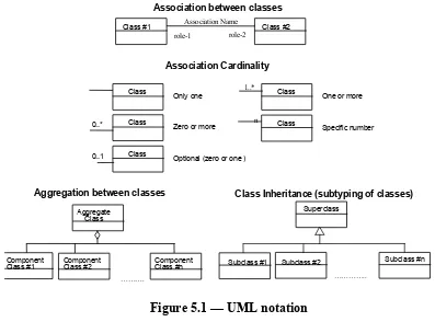
5.2 UML
Notation
The diagrams that appear in this document are presented using the Unified Modeling Language (UML) static structure diagram. The UML notations used in this document are described in the diagram below.
Association between classes
role-1 role-2 Association Name
Class #1 Class #2
Association Cardinality
Class Only one
Class
Zero or more
Class Optional (zero or one )
1..*
Class One or more
n Class
Specific number
Aggregation between classes
Aggregate Class
Component
Class #1 ComponentClass #2 ComponentClass #n
……….
0..*
0..1
Class Inheritance (subtyping of classes) Superclass
Subclass #1
…………..
Subclass #2 Subclass #n
Figure 5.1 — UML notation
The following three stereotypes of UML classes are used:
a) <<Interface>> A definition of a set of operations that is supported by objects having this interface. An Interface class cannot contain any attributes.
b) <<DataType>> A descriptor of a set of values that lack identity (independent existence and the possibility of side effects). A DataType is a class with no operations whose primary purpose is to hold the information.
c) <<Enumeration>> A data type whose instances form a list of alternative literal values. Enumeration means a short list of well-understood potential values within a class.
d) <<CodeList>> A flexible enumeration for expressing a long list of potential
alternative values. If the list alternatives are completely known, an enumeration shall be used; if the only likely alternatives are known, a code list shall be used.
e) <<Type>> A stereotyped class used for specification of a domain of instances (objects), together with the operations applicable to the objects. A Type class may have attributes and associations.
In this document, the following standard data types are used: a) CharacterString – A sequence of characters
b) Integer – An integer number
c) Double – A double precision floating point number
d) Float – A single precision floating point number
6 Background
6.1 Motivation
While sensors play a fundamental part of our everyday lives, as well as play vital roles within the environmental, intelligence, emergency management, and defense
communities, the state of the art is of heterogeneous networks of disparate sensors. These sensors are rarely easily discoverable, and access and processing of observations from these sensors are often confined to stovepipe systems. Even if interoperability has been achieved to some degree within a given sensor community, it usually comes at a cost of inflexible turnkey systems that are expensive and difficult to maintain and extend. The ability to easily discover, access, and process sensors existing within different
communities is very rare. SensorML provides a common framework for describing virtually any sensor system, as well as the processing that might be associated with these sensor systems.
The importance of long-term monitoring of the Earth’s environment and the development of improved data processing techniques, has raised awareness of the need for preserving low-level sensor data and the information required for reprocessing this data.
Unfortunately, such information is often lost or difficult to find five to ten years after completion of a sensor’s original mission life. The proposed SensorML is one step toward preserving part of the vital information. required for geolocation and processing of sensor data for both real-time and archival observations.
Often one is unaware of private or public sensor systems that are available for a particular application. Particularly in disaster prevention or remediation, it is vital that one be able to discover and gather observations of relevance from any appropriate sensors in the affected area. SensorML provides a standard means by which sensor and platform
capabilities and properties can be published and discovered. As will be discussed in more detail below, SensorML also provides information that allows for geolocation and
processing of these sensor observations without a priori knowledge of the sensor’s properties.
Web-enabled sensors provide the technology to achieve rapid access to accurate environmental information from the field. Streaming sensor information in standard formats facilitates integration, analysis, and creation of various data “views” that are more meaningful to the end user and avoids the drawbacks of locating and accessing incompatible archived data. This provides a significant advantage in that it reduces the time lag between making measurements and applying those measurements in decision-making. Time savings are particularly noticeable in the management of time critical events such as emergency response, advanced warning systems, and forecasting. A second benefit is in the routine use of data for everyday decision-making. Together, these developments will advance the realization of an integrated, yet distributed, monitoring and assessment system used by government, researchers, businesses, and the public in improving decision making based on high quality, near real time data and information. Furthermore, recent research and development activities have demonstrated several significant benefits of providing demand sensor geolocation within desktop or on-board tools. These include:
• Significant reduction of distributed data from remote sensors; large data volumes resulting from the distribution and storage of per-pixel latitudes and longitudes, as well as other pre-processed geometric relationships can be replaced with the calculation of these values on-demand;
• Improved capabilities for visually integrating and analytically comparing multi-sensor data;
• The ability to more easily correct geolocation errors from within the end-user tools and to redistribute these corrections to the user community;
• The ability to take advantage of several adaptive methods in computer graphics for improving interactivity within visualization tools; and
• Greatly improved capabilities for search and query of spatial-temporal sensor data without the need to request and perhaps store large data sets
SensorML supports the ability to describe the process by which an observation is measured or derived, and can therefore provide the lineage of a sensor observation or simulation results. Using the same framework, SensorML also provides the ability to provide executable process chains for deriving higher-level information. This might support, for example, on-the-fly geolocation of remote sensor observations or on-demand processing of raw data into more meaningful results.
Traditionally, the geolocation and processing of low-level sensor data has required
writing or utilizing software specifically designed for that sensor system. The availability of a standard model language for describing platform position and rotation, as well as instrument geometry and dynamics, allows for the development of generic multi-purpose software that can provide geolocation for potentially all remotely sensed data. The availability of such software in turn provides a simple, single Application Programming Interface (API) for tool developers to incorporate sensor geolocation and processing into their application software.
One intent of the SensorML standard is to allow the development of software libraries that can parse these files and calculate required look angles and timing for each sensor pixel. Other efforts are establishing standards for storage and transmission of sensor platform location and rotation in order to insure that such formats are also maintained, available, and readable by similar APIs.
6.2
Importance to archival needs
A standard description format for sensors is important for the long-term definition of the sensor model’s fundamental characteristics and assumptions for use in future
reprocessing and refining of sensor data.
We are currently entering an era of Earth observation in which we have realized the importance of long-term observation of the Earth’s environment. Thus, archiving the raw or low-level sensor data for future reprocessing has taken on greater importance. Equally important is that we preserve the characteristic metadata and assumptions required to reprocess the sensor data. The characteristic data include what is needed for geolocation, calibration, and radiometric processing of the remotely sensed data. Simply archiving the
latitude and longitude values will not only be expensive, but will also prove to be highly inadequate. It is anticipated that further efforts within organizations such as the CEOS Data Subgroup, ISO TC211, and the Open Geospatial Consortium, will be directed toward insuring proper standardization and archiving of other required data, such as platform position and rotation, and target or planet models. This current paper is directed specifically at the adequate description and standardization of fundamental geometric, dynamics, and measurement characteristics of the sensor.
As an example, sensor look angles have traditionally been either pre-calculated and stored within a data array structure, or calculated as needed within software systems developed specifically for that sensor. With time, unfortunately, the actual parameter values for the geometric and dynamic characteristics of the sensor are often lost as contract reports and software become obscure, and as look angle arrays and hardwired software prove difficult to deconvolve into the characteristic sensor parameters. Once the initial mission has been completed and the processing teams dispersed, reprocessing, correction, or refinement of the sensor data thus become very difficult, if not impossible. For example, this was the case for reprocessing of the archived Optical Line Scanner (OLS) data (Ken Knowles/University of Colorado, personal communication), as well as for the 20 year-old data from the Viking Mission to Mars (Bill Taber/JPL, personal communication).
6.3
Importance to software support
The standardization and the availability of SensorML documents for all sensors will allow for significant opportunities for software systems to support the processing, analysis, and visual fusion of multiple sensors.
Traditionally software that supported multiple sensors has been forced to deal with proprietary software designed for each individual sensor. When such software systems still exist and can be located, the software developer is often faced with trying to merge incompatible software architectures and development languages, or with rewriting the software to meet the requirements of his or her software. Even then, the addition of each new sensor system that the developer wishes to support requires the development of individual software modules specific to that sensor, often resulting in redundant code for manipulating and transforming the data.
In contrast, SensorML is based on the concept that the availability of standard sensor system descriptions allows for the development of general processing software capable of geolocating and transforming any sensor data for which such a description exists. This concept is built around the availability of description files for providing sensor-system specific information regarding platform position and rotation, instrument geometry and dynamics, target planet shape and position, and perhaps other time-tagged information, such as data dropouts, instrument modes of operation, or spacecraft clock adjustments. This concept is dependent on the availability of generic software for parsing these files, and calculating the transformations required to geolocate, and execute processing of the sensor data. A significant advantage of this concept for the developer and ultimately the end user, is that it provides a single source, single application programming interface, for
the geolocation and processing of any sensor system, rather than requiring the developer to locate and implement proprietary software for each sensor system.
In addition, this concept allows for the development of tools that can provide on-demand geolocation and mapping. As SensorML-enabled application software becomes more common, there will be less need to store and distribute volumetrically costly latitude, longitude, altitude, and incident angles values per pixel. Furthermore, correction of sensor geolocation requires only the redistribution of much smaller description files, rather than the redistribution of large collections of reprocessed sensor data. In fact, correction or refinement of geolocation can be conducted by the end user as necessary, rather than relying strictly on the instrument team. Finally, the ability to provide spatial-temporal knowledge of the sensor’s coverage, independent of the on-line presence of sensor data, allows much needed search and query capabilities for determining sensor coverage for given a location or time, or for determining coincident sampling between two or more sensors.
In addition to the significant benefits discussed above, on-demand processing of geolocation has in many cases been shown to be as fast or faster than reading in and processing pre-calculated location values. With CPU power increasing faster than I/O rates, the improvement in on-demand calculation of geolocation will increase even further in the future, with the added benefit of not wasting valuable capacity with storage of blocks of latitude and longitude values.
6.4
Importance to Sensor Web Enablement
The SWE architecture and design provides an important contribution for the enablement of future sensor webs. However, it is important to note that while SensorML is a key component to the SWE initiative, SensorML is not dependent on the SWE framework and can be used on its own or in conjunction with other sensor system architectures.
In much the same way that HTML and HTTP standards enabled the exchange of any type of information on the World Wide Web, the OGC Sensor Web Enablement (SWE)
initiative is focused on developing standards to enable the discovery and exchange of sensor observations, as well as the tasking of sensor systems. The functionality that has been targeted within a sensor web includes:
• Discovery of sensors and sensor observations that meet our needs
• Determination of a sensor’s capabilities and quality of measurements
• Access to sensor parameters and processes that automatically allow software to process and geolocate observations
• Retrieval of real-time or time-series observations and coverages in standard encodings
• Tasking of sensors to acquire observations of interest
• Subscription to and publishing of alerts to be issued by sensors or sensor services based upon certain criteria
SensorML is a key component for enabling autonomous and intelligent sensor webs. SensorML provides the information needed for discovery of sensors, including the sensor’s capabilities, location, and taskability. It also provides the means by which real-time observations can be geolocated and processed “on-the-fly” by SensorML-aware software. SensorML describes the interface and taskable parameters by which sensor tasking services can be enabled, and allows information about the sensor to accompany alerts that are published by sensor systems. Finally, intelligent sensors can utilize
SensorML descriptions during on-board processing to process and determine the location of its observations.
7
Design Criteria and Assumptions for
SensorML
7.1
Basic definition of a sensor
Sensors are devices for the measurement of physical quantities. A sensor measurement can be modeled as a process by which an input phenomenon is observed by the sensor at some discrete moment in time. Some measure of some property of that phenomenon is then output from the sensor. The values of the measurement are dependent on the sampling and response characteristic of that sensor, as well as on the sampling and detection methodologies. Often, either through hardware processing or subsequent processing in software, the raw observations are processed to higher-level knowledge. The SensorML model does not try to define where observation measurement and observation processing begin or end. These are both simply considered as part of the process.
There are a great variety of sensor types from simple visual thermometers to complex electron microscopes to radiometers on-board earth orbiting satellites. In some cases, sensing may be accomplished by a person rather than a device, and the result of the “measurement” may be a category rather than a numeric quantity.
Typically, sensors fall into one of two basic types. In-situ sensors measure a physical property of the medium immediately surrounding the sensor, while remote sensors measure physical properties which can be associated with features at some distance from the sensor, generally by measuring radiation reflected or emitted from an observed object. Regardless, any geometric properties described within the SensorML schema are defined within the sensor’s local coordinate frame and are only related to the geospatial domain through it frame’s association with the platform, mount, and their association with some geospatial reference frame. For example, to fully describe a wind profiler’s wind speed and direction measurements, the height of the sensor needs to be known as that sensor could be situated on the roof of a building, mounted to a 10-meter tower, or sitting at ground-level.
7.2
Applications of SensorML
There are at least three fundamental approaches to implementing and utilizing SensorML instance documents. In the first approach, one would define a sensor system description that remains valid over a long period of time (including perhaps the future), and all time-varying parameters or other data would be considered as potential input into the system process chain. This method can support both real-time and archived observations and provides maximum flexibility for on-demand discovery and processing of observations. The second approach is to provide a SensorML system description that is only valid over a certain period of time. For example, a data supplier might provide a satellite image derived from a scanner, and as part of the metadata for that image, would provide a SensorML system description that allows one to geolocate or further process that imagery data.
The third approach considers a SensorML instance document as instructions on how to further process existing data. In other words, a scientist could advertise and provide a particular algorithm, using a SensorML process chain definition, that can take Earth observations from a particular sensor and derive sea surface temperature or algae concentration, for example. Applying this “drag-n-drop” executable process to any segment of the observed data would allow on-demand generation of this higher-level product, as well as enable the ability to tweak parameters within the algorithm, perhaps. In additional, one could provide simply a process chain that allows geolocation of remotely sensed observation, without necessarily needing to describe the process by which the observations were made.
7.3
Sensor aggregation concepts
Detectors are typically simple devices (real or virtual) that take one input signal and generate one or more output signals. These are typically based on simple models that map the input values to output values, based on a few fixed or adjustable parameters. There are other simple processes that might exist either in hardware or software that do basic conversion of input to output. The methodology for each of these devices is fairly well defined and can be supported in software using a general model consisting of calibration curves and look-up-tables. In SensorML, these simpler atomic processes are defined as “process models”, if they are pure processes with no real connection to a spatial or temporal domain, and as “components” if they are physical processing devices, such as detectors and actuators.
Sensors typically consist of several such processes that can be linked in series or parallel resulting in a mapping from input to output that is better defined as a process chain. Other chains can be conceived that take inputs and through a series of individual processes generates new output values. In SensorML, these composite processes are modeled as “process chains” if they are pure processes that don’t exist in the physical domain. For most sensors of interest to the geospatial community, there is a need to relate the sensor observations to some temporal and spatial domain in order for them to be relevant. In SensorML, composite processes that can be related in space and time are modeled as a ”system”. Thus, typically, a System defines a collection of sensors that are related spatially and temporally to one another, as well as related to some geospatial domain. Process chains and systems in SensorML use the Composite Design pattern, such that a process chain is itself a process, such that it can have inputs, outputs, and parameters, and can itself participate as part of a bigger process chain. [PAT1995]
7.4
Relationship of the sensor to a platform
A sensor system is typically composed of one or more sensors mounted on a platform. Only the sensor element is viewed as being able to measure physical quantities. A platform such as an aircraft (carrying a frame camera) may be able to determine its own instantaneous orientation and position, and in such a case, these measurements would be obtained by other sensors attached to the platform. Within SensorML, platforms and sensors are treated as separate entities. Typically a sensor will be modeled as consisting
of one or more detectors, whereas a platform will be modeled as a System that contains all of the sensors and defines positional and temporal relationships among them. The platform may be staionary or moving with respect to the geodetic reference frame. For moving platforms, the geospatial position and orientation of a sensor is often derived from the platform on which it is mounted. It is therefore often beneficial to relate the sensor’s coordinate frame to the coordinate frame of the platform’s (e.g., through mounting angles and position) and then depend on the platform for determining
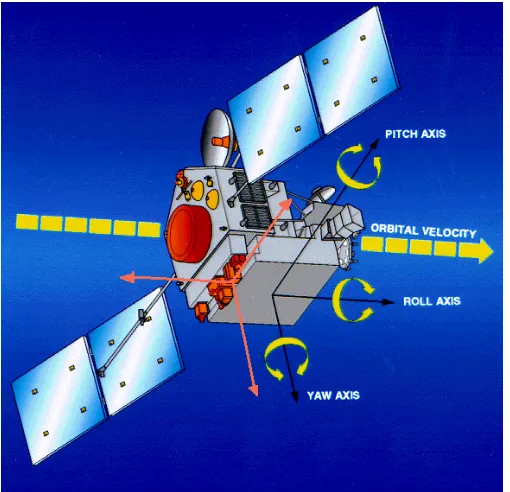
geospatial positioning. It is also possible to ignore the platform’s reference frame, and to strictly provide positional information relative to other sensors that provide positional observations (e.g., a GPS or IMU device). All of the frames of reference in SensorML can in general be dynamic or static. Figure 7.1 illustrates the relationship of a sensor’s frame (in pink) that is fixed but has been translated and rotated relative to the moving spacecraft frame (in black).
Figure 7.1. Relationship of sensor frame (pink) to the moving platform frame (black).
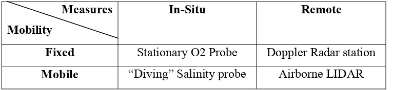
Based on the type of sensor and on the characteristics of the platform, a sensor system can be classified according to Table 7.1. Based on the dynamics of the platform, a sensor system may be fixed (stationary) or mobile (dynamic). Based on the sensor
characteristics, a sensor system may measure either in-situ (in place) or remotely. Thus, a remote sensing atmospheric profiler might be fixed to the ground (fixed remote) or
attached to an aircraft (mobile remote). Similarly, an in-situ water quality sensor might be attached to a fixed station (fixed in-situ) or to a boat (mobile in-situ).
As previously discussed, we separate the description of the sensor from that of its platform. The main importance of the associated platform(s) is in providing the