3D DOCUMENTATION OF
A HISTORICAL MONUMENT USING TERRESTRIAL LASER
SCANNING CASE STUDY: BYZANTINE WATER CISTERN, ISTANBUL
T. Temizer a, G. Nemli a, E. Ekizce b, A. Ekizce b , S. Demir c, B.Bayram d, Askin F.H e, A. V. Cobanoglu f, H. F. Yilmaz g
a Fatih Municipality, Survey and Project Department, 34080 Fatih, Istanbul, Turkey - (taliptemizer,
gulsennemli)@fatih.bel.tr
b MDM Mimarlik, 34365 Sisli, Istanbul, Turkey - (eylem, ali)@mdmmimarlik.com c
Imge Harita, 34730, Goztepe, Istanbul, Turkey - [email protected]
d YTU, Civil Engineering Faculty, Department of Geomatic Engineering, Division of Photogrammetry, Davutpasa
Campus, 34210 Esenler, Istanbul, Turkey - [email protected] e
Msc. Geomatic Engineer, Istanbul, Turkey - [email protected] f
IU, Bachelor of Arts Faculty, Dept. of Art History, 34452, Fatih, Istanbul, Turkey - [email protected] g Art of History, Istanbul, Turkey - [email protected]
KEY WORDS: Cultural Heritage, Terrestrial Laser Scanning, 3D Modelling, Point Cloud
ABSTRACT:
3D modelling of architectural structures for monitoring, conservation and restoration alterations in heritage sites has special challenges for data acquisition and processing. The accuracy of created 3D model is very important. In general, because of the complexity of the structures, 3D modelling can be time consuming and may include some difficulties. 3D terrestrial laser scanning technique is a reliable and advantageous method for reconstruction and conservation of monuments. This technique is commonly acknowledged due to its accuracy, speed and flexibility. Terrestrial laser scanners can be used for documentation of the cultural heritage for the future. But it is also important to understand the capabilities and right conditions of use and limitations of this technology.
Istanbul is a rich city with cultural monuments, buildings and cultural heritage. The presented study consists of documentation of a Byzantine water cistern situated underground the court of Sarnicli Han building. The cistern which represents a very good living example of its period has been modelled in 3D by using terrestrial laser scanning technology and the accuracy assessment of this modelling is examined.
.
1. INTRODUCTION
Inspecting, monitoring, modelling, restoring and preserving of historical monuments in 3D require automated and accurate methods (Askin, et al., 2011; Abmayr, 2005). 3D advanced measurement techniques are becoming a potential and efficient tool for preservation and mapping (Wei (a), et al., 2010; Demir, et al, 2004). Terrestrial laser scanners (TLS) can collect a large number of 3D points for reconstruction of 3D models of objects (Wei (b), et al, 2010). Three different methods can be widely used for modelling of cultural objects; (i) photogrammetry, (ii) TLS, (iii) combination of TLS and photogrammetry (Lerma, et al, 2010). Photogrammetry is a useful and accurate method for complex objects. TLS has also become an advanced technology for 3D modelling issues nowadays. Compared to photogrammetry, TLS produces 3D point clouds during the measuring process (Haddad, 2011) and it offers continuous monitoring opportunity. Historical objects can have damaging risk by atmospheric agents and other external factors (Pieraccini, et al., 2001) and the rapid TLS technique provides documentation of the objects without requiring a direct contact with the object. Since the restoration of historical buildings needs detailed information such as comprehensive determining
of the structure, types of materials and reliable 3D model of historical objects; TLS technique is a very efficient data collecting tool, because it is the first one of all non-invasive surveying techniques. The gathered information can easily be integrated with high resolution digital images and converted into the CAD systems (Pesci, et al., 2012). Change detection on the object is also made precisely possible by using TLS technique: 3D models of cultural objects -before and after the restoration- can be created easily (Vela, et al. 2010).
In the presented study, Sarnicli Han has been scanned with Faro Focus 3D laser scanner. For 3D modelling of Sarnicli Han, Geomagic commercial software has been used. Rapidform commercial software (trial version) has been used also for accuracy analysis and analyzing the data for reduction and finding the best set of data.
2. STUDY AREA
other cisterns were built. One of them is Cistern of Philoxenos (Binbirdirek) which dates back to 5th century and is situated between the Forum and the Hippodrome of Constantinople. Another well known and large cistern is Basilica Cistern. It’s known that there were more than 60 various sized cisterns built during Byzantine era (Eyice, S. 2013)
Sarnicli Han is on the west of Grand Bazaar in Istanbul in Turkey, where Cadircilar Street and Muhurdar Street intersect (Block 647, Parcel 30-31) (Figure 1). The building is consisting of two underground and two normal floors, as the court being the entrance level is about 2 meters above the street level. The Cistern is accessed via a two-flight staircase hidden under a metal lid on the North-Eastern corner of the court.
Figure 1. The location of the Sarnicli Han in cadastre map
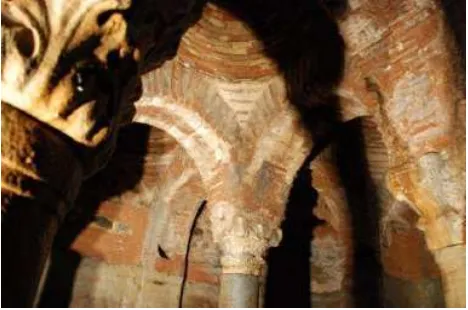
The Cistern has a square-like plan scheme with sides of 8.0 x 8.0 x 8.3 x 9.8 meters and height of 7.10 meters from ground to the keystone of dome. 3 corners of the inner walls being hydraulic plastered (Figure 2) below the arches are chamfered; and the fourth corner protruding outwards has an oval shape. On 6 of the 10 domes that form the topmost structure, there are cylindrical ventilation shafts that may also be used for access to take out water from above. Brick masonry can easily be observed on the non-plastered upper part of the construction, starting with the arches (Figure 3). The thick layer of mortar observed between thick bricks in arches and pendentives tells us that these parts are made up with “concealed brick laying technique”. There are stripes on grouts which are made with a trowel. It’s known that this brick laying technique was used between 11th and 12th centuries. Thus, it is reasonable to address the Cistern to Middle Byzantine Period. Probably the Cistern was under another structure during the Byzantine Period, hence it can be said that there may be traces of other ruins around. Possibly alterations to walls were made by applying cement based mortar on time of the reconstruction of the han. The Cistern, situated within Block 647/Parcel 31 is listed as a “cultural heritage to be preserved” by the order of “1st Committee of Conservation of Cultural and Natural Heritage of Istanbul” dated 19.04.1988 and issued 297.
Figure 2. Hydraulic plastered walls of the cistern
Figure 3. Brick masonry of the arches supporting domes
Sarnicli Han is situated in is called “Region of Hans” that consists of 8 hans and additional independent parcels around these; and they carry too much importance with their relation to Grand Bazaar, being connected economically and physically. As we know that the Grand Bazaar is always mentioned as the first shopping mall of history, these hans are the places that enclose shops, stores, ateliers, workshops, warehouses and accommodation that support and supply to Grand Bazaar. Both the Region of Hans and Grand Bazaar are functionally permanent areas of traditional economy and trade through human history.
3. MATERIAL AND METHOD
The cistern has been scanned with Faro Focus 3D laser scanner. The instrument distributes the laser beam at a vertical range of 3050 and a horizontal range of 3600. The measurement rate is up to 976,000 points per second. Distance accuracy is up to +/-2 mm, its range is between 0.6 m and 120 m in daylight and it reaches up to 153 m in closed areas.
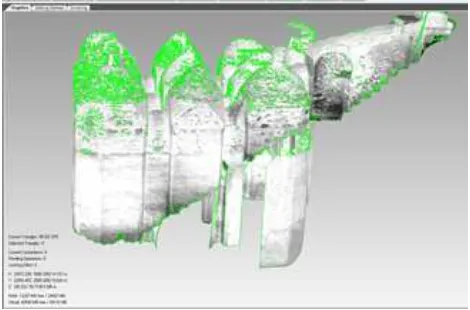
Figure 4. General workflow data processing
Figure 5. Scanning plan of the cistern
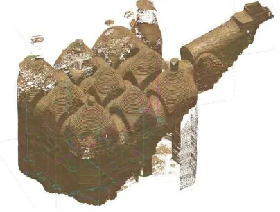
The scanning has been realized from fifteen stations. Ten of them were inside stations and used to scan walls and ten domes, three of them were at the entrance and last five stations were used to scan stairs. The cistern has ten domes therefore the scanning process was made from ten stations. By using ground control points which have been placed on the exterior walls of the cistern, point clouds have been registered to the ground coordinate system. The scanning distance was 10 meters; the footprint size had a 3 mm diameter. The modelling result is given in Figure 6.
Figure 6. Reconstructed 3D model of the cistern
Due to density of the point cloud, processing can be time consuming as well as it was in the presented study. But medium density point cloud may not be such difficult (Wand et al., 2008). If 536 million points of point cloud is taken into consideration, it can be apparently found out that their
processing takes a lot of time (Roca-Pardiñas, et al., 2008).Therefore, point clouds have to be filtered before modelling. Filtering is necessary not only for reduction of points, but also for noise reduction. In the presented study, in the first step the level of filtering has been researched. Therefore, the original point cloud data has been filtered 25%, 50% and 75%; and mesh smoothing has been researched to find accurate and efficient set of data.
After filtering operation, mesh models have been created for each filtered point cloud data set. Again, each mesh models have been smoothed in the minimum, medium and maximum level. There are several methods for surface reconstruction. One of them is B-spline (NURBS) curves, which is used commonly because of their accurate approaching for surface reconstruction (Sun, et al, 2001). Delaunay triangulation method is also a favourite method (Gao, vd. 2012) for many commercial types of software such as “Geomagic” and “Rapidform” which were used in the presented study. Mesh quality affects the accuracy of the result. The Voronoi/Delaunay approach is used due to its strong capability. However, the created mesh should be smoothed after applying mesh generation methods to reduce noise and mesh errors (Vartziotis, vd., 2013). In the presented study, reference mesh model has been created from original point cloud data first(Figure 7). Than minimum, medium and maximum smoothed mesh models from 25% filtered point cloud, from 50% filtered point cloud and from 75% filtered point cloud have been created. The medium smoothing results for 25% , 50% and 75% filtered point clouds have been given in Figure 8-a,b,c.
Figure 8-a. Medium mesh models from 25% filtered point cloud
Figure 8-b. Medium mesh models from 50% filtered point cloud
Figure 8-c. Medium mesh models from 75% filtered point cloud
Due to complexity and type of material of the Sarnicli Han, some holes appeared after scanning. The holes have been filled and evaluated for each filtering and related mesh smoothing level. In the presented study, the holes have been filled for meshes which have been created from 25%, 50% and 75% filtered point cloud data and smoothed minimum, medium and maximum. For hole filling, linear and curvative methods have been used. The curvative hole filling results for 25% filtered point cloud and medium smoothed mesh, 50% filtered point cloud and medium smoothed mesh and 75% filtered point cloud and maximum smoothed mesh have been presented in Figure 9-a,b,c.
Figure 9-a. 25% filtered point cloud and medium smoothed mesh
Figure 9-b. 50% filtered point cloud and medium smoothed mesh
Figure 9-c. 75% filtered point cloud and maximum smoothed mesh
4. RESULTS AND DISCUSSION
survived almost a thousand years, with its authentic workmanship, almost intact materials and texture that gives you the feeling of travelling through ages. Of course, compared to other great cisterns of Istanbul that supplied water to thousands of people; this one is yet small, but is a very rare example of this size cisterns with this quality.
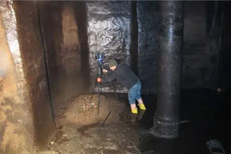
The restricted maneuver area and difficult working conditions such as; lack of fresh air, darkness, difficulty to stay for a long time period because of bad odor and harmful gases, the certain level of water in the cistern and difficulties to discharge it, thick layer of mud covering the floor, limited the number of scanning stations. Therefore some of the scans resulted with uncovered areas. By the help of the 3D scanner that was positioned and stabilized on proper points, the scanned data was integrated with high-resolution photographs and control measurements made with total-station, handheld laser distance-meter and simple tape measures. At the end, an almost perfect and accurate model of the cistern was obtained.
It can be said that the presented study can be considered as one of the most appropriate proofs of effective use of terrestrial laser scanning technology. If the position of the cistern, illumination conditions and difficulty of access to the cistern is taken into consideration, it can easily be seen that it is impossible to document and model this monument with the help of any other techniques (Figure 10-a,b).
Figure 10-a. Working conditions inside the cistern
Figure 10-b.Level of the mud and water on time of scanning
The results of filtering and smoothing steps have been evaluated. For this, 30 reference control points on the mesh from original point cloud have been measured. These points
have been compared with the measurements on the minimum, medium and maximum smoothed meshes from %25 filtered point cloud data, %50 filtered point cloud data and %75 filtered point cloud data. The results have been presented in Table 1.
As it can be seen in Table 1, maximum difference between the original mesh and smoothed meshes created from filtered point cloud data is 1.82 mm. This difference is between original mesh and maximum smoothed mesh from %75 filtered point cloud data. If the results have been interpreted, it can be seen that % 50 filtered and medium smoothed mesh data is available and acceptable for reconstruction of Sarnicli Han. Thus, processing time can be reduced dramatically without meaningful data loose. But this result is limited with this presented study only. Different objects have to be processed and analyzed to generalize obtained results from this study. The cistern which represents very good living example of its period has been modelled in 3D by using terrestrial laser scanning technology. The experience obtained from this study was not only about using this technology in difficult circumstances, but also about the methods to be followed in. We are planning to develop efficient algorithms for integration of laser scanning results with point clouds collected with photogrammetric method; to enhance hole filling results, by merging point cloud data -which are created from both TLS and photogrammetric
REFERENCES
Abmayr T., Härtl F., Reinköster M., Fröhlich C., 2005. Terrestrial Laser Scanning-Applications In Cultural Heritage Conservation And Civil Engineering
http://www.isprs.org/proceedings/XXXVI/5-W17/pdf/19.pdf (20 June 2013).
Benli, G., 2007. Han Buildings in Historical Peninsula of Istanbul and Conservation Issues of Han Buildings with Courtyards, PhD Thesis, Y.T.U. Graduate School of Science, Istanbul.
Demir N., Bayram B., Alkis Z., Helvaci C., Cetin I, Voegtle T., Ringle K., Steinle E., 2004. "Laser Scanning for Terrestrial Photogrammetry, Alternative System or Combined with Traditional System" (poster), XXth Congress International Society for Photogrammetry and Remote Sensing, Proceedings, Commission V, p. 193 – 197, 12-23 July ,Istanbul, Turkey.
Eyice, S., 2013. Semavi Eyice ile Istanbul’a Dair. IBB Kultur A.S. Yayinlari, Istanbul.
Feyza Hale Askin, Bülent Bayram, D. Zafer Şeker, Solution For The Problems Encountered During The Modeling Of Terrestrial Laser Scanner Data, XXIIIrd International CIPA Symposium Proceedings http://dev.cipa.icomos.org/index.php?id=69, Prague, Czech Republic, September, 12-16, 2011.
Firatli, N., Yucel, F., 1952. Some Unknown Byzantine Cisterns Of Istanbul, Turkiye Turing ve Otomobil Kurumu, Istanbul
Forchheimer, P., Strzygowski, J.. 1893. Die Byzantinischen Wasserbehälter Von Konstantinopel, Druck und Verlag Der Mechitharisten Congregation, Wien
Gao Zhanheng, Yua Zeyun, Holst Michael, 2012. Quality tetrahedral mesh smoothing via boundary-optimized Delaunay Triangulation, Computer Aided Geometric Design 29 (2012) 707–721.
Guran, C., 1976. Evolution of Turkish Han Buildings and Architecture of Han Buildings of Istanbul, Vakiflar Genel Mudurlugu Yayinlari, Ankara
Haddad Naif Adel, 2011. From ground surveying to 3D laser scanner: A review of techniques used for spatial documentation of historic sites, Journal of King Saud University – Engineering Sciences (2011) 23, 109–118.
Lerma Jose´ Luis, Navarro Santiago, Cabrelles Miriam, Villaverde Valentin, 2010. Terrestrial laser scanning and close range photogrammetry for 3D archaeological documentation: the Upper Paleolithic Cave of Parpallo as a case study, Journal of Archaeological Science 37 (2010) 499–507.
Pesci Arianna , Bonali Elena, Galli Claudio, Boschi Enzo, 2012. Laser scanning and digital imaging for the investigation of an ancient building: Palazzo d’Accursio study case (Bologna, Italy), Journal of Cultural Heritage 13 (2012) 215–220.
Pieraccini Massimiliano, Guidi Gabriele, Atzeni Carlo, 2001. 3D digitizing of cultural heritage, Journal of Cultural Heritage 2 (2001) 63−70.
Roca-Pardiñas J., Lorenzo H., Arias P., Armesto J., 2008. From laser point clouds to surfaces: Statistical nonparametric methods for three-dimensional reconstruction, Computer-Aided Design 40 (2008) 646–652.
SunW., Bradley C., Zhang Y.F., Loh H.T.,2001. Cloud data modeling employing a unified, non-redundant triangular mesh, Computer-Aided Design 33 (2001) 183-193.
Vartziotis Dimitris, Wipper Joachim, Papadrakakis Manolis, 2013. Improving mesh quality and finite element solution accuracy by GETMe smoothing in solving the Poisson equation, Finite Elements in Analysis and Design 66 (2013) 36–52.
Vela Ela, Babic Luka, Dapo Almin, Kordic Branko, Pribicevic Boško, Medak Damir, 2010. Terrestrial laser scanning for the digital preservation of a Croatian historical village “Dobranje” FIG Congress 2010 Facing the Challenges – Building the Capacity, Sydney, Australia, 11-16 April 2010, p.1-14
Wand Michael, Berner Alexander, Bokeloh Martin, Jenke Philipp, Fleck Arno, Hoffmann Mark, Maier Benjamin, Staneker Dirk, Schilling Andreas, Seidel Hans-Peter, 2008. Processing and interactive editing of huge point clouds from 3D scanners, Computers& Graphics 32 (2008) 204–220.
Wei(a), O. C., Chin, C. S., Majid, Z., Setan, H., 2010. 3d Documentation And Preservation Of Historical Monument Using Terrestrial Laser Scanning Geoinformation Science Journal, Vol. 10, No. 1, 2010, pp: 73-90.
Wei(b) Yan , Ajit Behera, Pankaj Rajan, Recording and documenting the chromatic information of architectural heritage, Journal of Cultural Heritage 11 (2010) 438–451.
ACKNOWLEDGEMENTS
The authors wish to thank undergraduate student Mehmet Can Yaras from Yildiz Technical University of Istanbul