APPLICATION OF DIGITAL TERRESTRIAL PHOTOGRAMMETRY IN
ARCHITECTURAL CONSERVATION: THE MOSQUE OF ABDULLAH IBN SALAM OF
ORAN
I.Boukerch, B. Takarli, R. Mahmoudi, S.Tellai, D.Chadli
Centre des Techniques Spatiales Arzew Oran Algeria - [email protected]
KEY WORDS: 3D modelling, terrestrial photogrammetry, camera calibration, accuracy
ABSTRACT:
Studies on the architectural heritage can now be supported by three-dimensional reconstruction of actual buildings. The 3D digital model can be an effective medium for documenting the current state of historic buildings but also to create a resource for researchers who conduct their analysis on historical evolution. Architectural photogrammetry has its own specifications in relation to other photogrammetric applications, however it meets these expectations.
The traditional approach requires the use of metric cameras but with the development of computational techniques, this requirement is overcome and opens the way for the use of non-metric camera.
The use of the shots that is no longer restricted to the parallel configuration of bundles, the images may be convergent, horizontal or oblique. Combining and modelling several cameras increasingly powerful in resolution and stability, has great scope and the same workflow can be used in varied applications.
ISPRS and ICOMOS created CIPA because they both believe that a monument can be restored and protected only when it has been fully measured and documented and when its development has been documented several times, i.e. monitored, also with respect to its environment, and stored in proper heritage information and management systems.
In this paper the 3D modelling of an important cultural site using terrestrial photogrammetric techniques for architectural preservation is presented. The site is the mosque of Abdullah Ibn Salam, Built in 1880 at the initiative of Simon Kanoui, also known as the Great Synagogue of Oran was inaugurated in 1918 only. It was one of the largest and most beautiful synagogues in North Africa. It was built with stone imported from Jerusalem. This place of worship became in 1975 the mosque of Abdullah Ibn Salam who was a rich Jew of Medina who was converted to Islam.
The structure is modelled using 321 oriented photos taken in five series of shots that cover all the façade and the interior of the building where more than 9200 points are created.
Also some orthophotos of the important elements are produced and used as materials in the final stage which is the edition in a 3D modelling software. And a video virtual tour is generated using this software.
1. OVERVIEW
1.1 Heritage in Algeria
Algeria is one of the countries that contain a large and diverse architectural heritage. It is inherited from different civilizations that have succeeded, from the Phoenician era to the Islamic civilization, also the ancient civilizations of the Sahara which have left their footprints in the Tassili and ahagar.
The Algerian government attaches strategic attention to the architectural heritage, at most, the ancient heritage of our ancestors. Now, the preservation and preventive maintenance of the national architectural heritage is a priority or even a challenge for the Ministry of Culture which has drawn up a strategy in the sense of preserving this piece of our history and identity.
The celebration of Heritage Month, held this year under the slogan "Heritage and Identity", provides information on the willingness and commitment of officials from the Ministry of Culture to maintain and preserve cultural and architectural heritage that are an essential part of the collective memory of the nation and this is reflected in the field by the start of several restoration sites and ancient monuments.
1.2 A promising methodology
The use of the close range photogrammetry for the architectural heritage preservation purpose require a knowledge how, hardware and software (A. N. Andrés et al. 2012) not always available in sufficient way to ensure their use in a under
developed country which is the case in Algeria. This obliged us to opt for a low cost solution that assure the standard accuracy and quality required for this kind of survey, and also can be easily introduced in to educational institutions (M. A. N. Andrés and Pozuelo 2009; Gomez-Lahoz and Gonzalez-Aguilera 2009; Colosi et al. 2009)
2. SITE DESCRIPTION
Oran (Wahran in Arabic), is the second largest city of Algeria and one of the largest in the Maghreb. It is a port city on the Mediterranean, north-western Algeria, and the chief town of the wilaya of the same name bordering the Gulf of Oran.
In 1877 the Jewish Consistory, at the initiative of Simon Kanaoui a rich merchant, decides to build a synagogue in Oran. It is located in the old Boulevard Joffre, renamed Boulevard Maata Mohamed El Habib. The land was given freely by the municipality. In 1880 the first stone was posed.
It was one of the largest synagogues in North Africa. Built with stone imported from Jerusalem. And on May 12, 1918 the synagogue was inaugurated (Figure 1). (Badia, 1997)
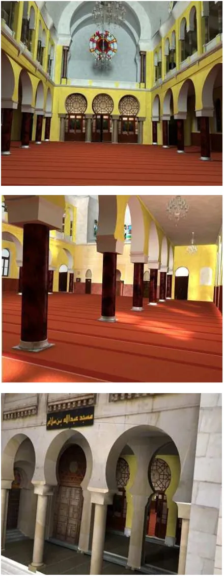
This site became in 1975 the mosque Abdellah Ben Salem(Figure 2), who was a rich Jew of Medina converted to Islam and remained faithful to his new faith to the end of his life.
Viewed from outside, the building is very important. The facade where a rose-colored stained glass windows illuminate the interior is adorned on each side of two towers of twenty meters high in which two wings are attached to the domes complete the The International Archives of the Photogrammetry, Remote Sensing and Spatial Information Sciences, Volume XLI-B5, 2016
harmonious whole. Within three large stained glass doors open onto overcome the nave (Badia, 1997).
Figure 1. synagogue of Oran 1927.
Figure 2. The mosque of Abdullah Ibn Salam 2010.
This one is separated from the aisles by arches decorated with arabesques and support columns of red marble (Figure 3).
3. PRELIMINARY WORKS
Since this is our first experience of using the close range photogrammetry for the cultural heritage in Algeria some preliminary works were done to understand the optimal way to use this technique.
Essentially the preliminary work was the calibration and the positioning accuracy assessment of this technique , also the use of targets give us a better accuracy so, what is the optimal size of the target to use? (Sanz et al. 2010).
3.1 Calibration and accuracy assessment
Concerning the camera calibration, the development of the digital cameras and the techniques of digital images analysis, let any digital camera can be calibrated and used for metric purposes, so its distortions, focal length and the exact position of the principal point must be determined with a sufficient accuracy (Sanz et al. 2010; Lerma et al. 2010; Barazzetti et al. 2011).
Figure 3. The interior of the mosque.
For the calibration of our cameras the software present two methods, the first is using The Calibration Grid which is a pattern of dots specifically designed for the Camera Calibrator. The second one is the method called Self/Field Calibration where an object is photographed responding to some special conditions so the software can extract the calibration parameters of the camera.
In our application two cameras are used SONY DSC W200 with a resolution of 12.1 Megapixels with a focal length of 7.6 to 22.8mm. The second one is the Olympus SP 500 UZ with a resolution of 6Megapixels and a focal length of 6.3 to 63 mm. The grid calibration method gives a focal length of 7.7018mm for the first one and 6.4040 mm for the second one. Also the other calibration parameters are extracted such as the format size, principal point and the lens distortions.
The field calibration gives slightly different results so the focal length of the Sony camera is 7.8035mm and 6.3677mm for Olympus.
To check the accuracy of these results, a calibration polygon of 36 points was created using a LEICA TC 1101 total station (Figure 4).
Figure 4. The calibration polygon.
The coordinates obtained by the photogrammetric way using the different calibration results are compared to the coordinates obtained using the total station.
Sony Olympus
Table 1. First calibration results using three points (results are in mm).
Table 1 present the statistics on the residuals in millimetres between the coordinates obtained from the photogrammetric measurement and the total station measurements, where Dx, Dy, Dz are the residuals in the X, Y and Z directions and D on the residual vector. The external orientation of the photogrammetric model was done using the minimum required of three points. The use of more points can increase the accuracy, so several tests were done using additional points, we notice that for five or more points the results are similar (Table 2).
Sony Olympus
Table 2. Second calibration results using five points (results are in mm).
Therefore, the field calibration technique is recommended since it gives a 1mm RMS on manually measured points (without the use of subpixel point measuring option which increases the accuracy), and the use of five points for the absolute orientation is recommended.
3.2 Targets size
The used software (Photomodeler) propose the creation of coded targets to provide an accurate sub-pixel point marking, the calculation of the size of these targets is based on a criteria where the central dot of the target must have about 10 pixels of diameter on the image (Barazzetti et al. 2011).
So if we use the Sony camera at a distance of 30 meters from the object the target size will be 372.68mm which is very large and can hide some interesting detail.
For this reason a test to determine the optimal target size have been performed. In this test four targets of different sizes (6, 15, 25 ad 35 mm) are printed on A4 sheet, 20 targets sets were to get the 3D position of the targets; the absolute orientation is done using five of the surveyed points.
We conclude that the targets of 6mm give the best result but cannot be used for a distance greater than 20 meters because they becomes barely visible, for a distance less that 40m the other targets gives a slightly similar results so the 15 mm target is preferred since it hide less details.
Figure 5. Targets distributed on the façade.
4. DATA ACQUISITION
The survey of the mosque of Abdullah Ibn Salam was carried out with a photogrammetric approach.
The images were captured using the SONY DSC W-200 camera with a resolution of 12Megapixels (4000*3000) and a single zoom position which was calibrated with a field calibration method and the focal length was 7.8035mm with a FOV of 51° ( field of view).
The images were acquired obeying to the 3x3 rules(Kasser and Egels 2001). In the field a methodological approach must be followed to guarantee the total and right cover of the whole site. For the parallelepiped or cylindrical objects the photos must be taken from all around the object (the ring method) (Figure 6).
Figure 6. photography ring.
For a façade, two series of shots were taken from a line parallel to the façade the first with an angle of 45° and the second with -45° (Figure 7)
Figure 7. photography positions for a façade.
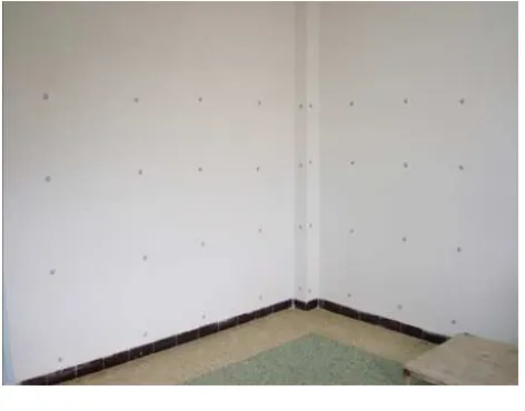
For a room two or more photos are taken from the centre of each wall to cover all the room corners (Figure 8).
Figure 8. photography positions for a room.
In the case of a corridor, if it is sufficiently wide it will be similar to the room case with multiple photographing stations along the long side (Figure 9).
Figure 9. photography positions for a wide corridor.
But, if the corridor is narrow the horizontal separation between photograph stations will provide low intersection angles which decrease the accuracy, so to resolve this problem we have used a vertical separation where two shots were taken from each position with different heights (Figure 10).
Figure 10. photography positions for a narrow corridor.
According to these rules 332 photos were taken to cover the mosque (façade, gate and entrance, prier hall 1st and 2nd floor). These photos were shot in five days by reason of 3hours per day when the mosque is unoccupied (avoiding the prier time).
5. ORIENTATION AND MODELLING
The first step and before the orientation process, is the photos selection where we eliminate the unusable photos (convergence problem, blurred...).
Due to the relatively height number of photos the project was divided into eight parts, with overlapping points, which simplifies the orientation and reduce the calculation time and the risk of orientation failure, at the end the eight parts are merged to get a unique project covering all the mosque. Each part is processed using PhotoModeler through the following workflow:
1. Importing photos 2. Camera definition 3. Photo idealization 4. Photos referencing 5. Orientation processing 6. Marking structural points 7. Line marking (Figure 11a)
8. Creating surfaces and cylinders (Figure 11b) 9. Texture extraction.
Figure 11. a. A model after line marking (up) b. a model after surfaces creation (bottom).
Once each part is finalized, we proceed to the merge step where we get a unique model based on 312 photos and contain about 9200 point. The obtained model is scaled and oriented using 3D scale and orientation tool (Figure 12).
Figure 12. The result merged projects Floor
5.1 3D extraction problems
Some problems are noticed (Figure 13): • Texture problems due to the lightening • Misplaced texture problems
• Non textured zones
Other problems are related to the software: • The use of only one distance for th • The orientation is base on 2 points • The lake of some modelling extrusion) that can reduce the phot
Figure 13. The misplaced texture and the li
5.2 The edition
To overcome these problems we export the Cinema 4D, one of the most known 3D mo software.
In this software we proceed first to the geom of the model, and all the missed surfaces. T apply texture for the essential elements suc columns, white and yellow paint, sto orthophotos for sculptures, frescos, arabes doors and windows (Figure 15).
5.3 Results
5.3.1 Orthophotos
Many orthophotos of the most important façade, frescos and the stained glasses (Figure 14).
ing conditions
the model scaling nts for each direction. ng tools (essentially hoto number.
e lightening problem.
the resulting model to modelling and edition
eometrical completing s. Then we create and uch as red marble for stones, carpet, and esques, stained glass
ant elements such as has been extracted
Figure 14. Example of the e
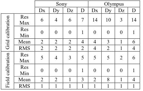
5.3.2 Photorealistic 3D model
A complete photorealistic 3D m interior of Abdullah Ibn Salam m definition render is performed to o the mosque.
e extracted orthophotos.
model of the façade and the mosque was created, and high o obtain a video virtual tour of The International Archives of the Photogrammetry, Remote Sensing and Spatial Information Sciences, Volume XLI-B5, 2016
Figure 15. Example of the final photorealistic 3D model
6. CONCLUSION
This is the first experience of using the close range photogrammetry for the cultural heritage preservation in Algeria. This experience permits us to determine the potentialities of applying photogrammetry in this field, also to reach the limits of this technique.
The field/self calibration technique is preferred to assure a better geometrical accuracy; as well the accuracy is depending to camera resolution, the lens quality and the camera positions.
In the general case for architectural modelling, where the maximum shot distance is about 40 meters, the best target size is 15mm.
Lots of products can be obtained using the close range photogrammetry, such as a metric document readable and interpretable by architect or archaeologist for archiving and restoration, orthophotos for safeguarding patterns and frescos, photorealistic 3D models for virtual visits, E-learning and tourism promotion.
Of course other solution exists (Haala and Kada 2010), like 3D laser scanning, but the low cost of the close range photogrammetry is a great advantage essentially for the developing countries.
REFERENCES
BADIA, P. 1997. AFN Collections, Bulletin n°10, http://afn.collections.free.fr/pages/10_bulletin/10_synago.html (28/04/2016).
Andrés, Amparo Núñez, Felipe Buill Pozuelo, Joaquín Regot Marimón, and Andrés de Mesa Gisbert. 2012. ‘Generation of Virtual Models of Cultural Heritage’. Journal of Cultural
Heritage 13 (1): 103–106.
Andrés, Ma Amparo Núñez, and Felipe Buill Pozuelo. 2009. ‘Evolution of the Architectural and Heritage Representation’.
Landscape and Urban Planning 91 (2): 105–112.
Barazzetti, Luigi, Luigia Binda, Marco Scaioni, and Paolo Taranto. 2011. ‘Photogrammetric Survey of Complex Geometries with Low-Cost Software: Application to the ‘G1′ Temple in Myson, Vietnam’. Journal of Cultural Heritage 12 (3): 253–262.
Colosi, Francesca, Gabriele Fangi, Roberto Gabrielli, Roberto Orazi, Andrea Angelini, and Carlo Alberto Bozzi. 2009. ‘Planning the Archaeological Park of Chan Chan (Peru) by Means of Satellite Images, GIS and Photogrammetry’. Journal
of Cultural Heritage 10: e27–e34.
Gomez-Lahoz, Javier, and Diego Gonzalez-Aguilera. 2009. ‘Recovering Traditions in the Digital Era: The Use of Blimps for Modelling the Archaeological Cultural Heritage’. Journal of
Archaeological Science 36 (1): 100–109.
Haala, Norbert, and Martin Kada. 2010. ‘An Update on Automatic 3D Building Reconstruction’. ISPRS Journal of
Photogrammetry and Remote Sensing 65 (6): 570–580.
Kasser, Michel, and Yves Egels. 2001. Photogrammétrie
Numérique. Hermès science publication.
Lerma, José Luis, Santiago Navarro, Miriam Cabrelles, and Valentín Villaverde. 2010. ‘Terrestrial Laser Scanning and Close Range Photogrammetry for 3D Archaeological Documentation: The Upper Palaeolithic Cave of Parpalló as a Case Study’. Journal of Archaeological Science 37 (3): 499– 507.
Sanz, Juan Ortiz, Maria de la Luz Gil Docampo, Santiago Martínez Rodríguez, María Teresa Rego Sanmartín, and Gonzalo Meijide Cameselle. 2010. ‘A Simple Methodology for Recording Petroglyphs Using Low-Cost Digital Image Correlation Photogrammetry and Consumer-Grade Digital Cameras’. Journal of Archaeological Science 37 (12): 3158– 3169.