MULTI GEOPHYSICAL OBSERVATIONS AT BLAWAN - IJEN VOLCANO
GEOTHERMAL COMPLEX FOR REGIONAL DEVELOPMENT
Sukir Maryanto1, Agus S Wicaksono2, Anjar P. Azhari3, Cinantya N. Dewi4, James Foster5, Ahmad Nadhir6,
Abdurrouf
71,6,7
Department of Physics, Faculty of Science, Brawijaya University, Malang, Indonesia. 2
Postgraduate Program, Brawijaya University, Malang, Indonesia. 3,4
Postgraduate Program of Physics, Faculty of Science, Brawijaya University, Malang, Indonesia. 5
Hawaii Instittute of Geophysics and Planetary, University of Hawaii, Manoa, USA. Email: [email protected], [email protected], [email protected], 4
[email protected], [email protected], [email protected], [email protected]
ABSTRACT
Geothermal resource investigation by using multi geophysical observation was accomplished for Blawan-Ijen geothermal system. Geological and surface investigation found about 21 hot springs have been found in Blawan area with the surface temperature ranged from about 40oC-55oC. Based on resistivity and GPR data known that the underground seepage of hot water following the fault direction. This fault structure is identified based on the high distribution of microseismicity and thermal infrared remote sensing (TIR) analysis which associated with high land surface temperature (LST). Meanwhile, the heat source of Blawan - Ijen geothermal system are found in the southwest part based on high magnetic anomaly which represents the igneous rocks. All methods used shows the results indicating that Blawan-Ijen volcano complex is an interesting area for geothermal energy development and suitable for pilot project on regional development of caldera (Fig. 1) formed more than 50,000 years ago as a result of the collapse of the Ijen stratovolcano (van Hinsberg et al., 2010). Ijen volcano is a part of Sunda-Banda volcanic arc stretching from Sumatra to Banda, along 3,700 km which is known to contain a lot of metal ore deposits (Carlile and Mitchell, 1994) and manifestations (Prabawa et al., 2013).
Fig.1. Ijen caldera
Blawan-Ijen volcano complex have both geothermal energy resources potential and plantation potential. The primary commodity is coffee, and the other commodities are timber,
106 P-ISSN:2356-3109 E-ISSN: 2356-3117 importance of this geothermal energy, some
visual observation and geophysical observations have been developed in search of this resources energy. The proposed study was designed to be an intial study of Blawan-Ijen geothermal prospect based on multi geophysical observations. Magnetic, geolectric resistivity, GPR, microearthquake and remote sensing observations have been done to analysis the quality and quantity of geothermal prospect and geohazard in Blawan-Ijen area.
Geomagnetic method is one passive method which is sensitive to analyze the geothermal reservoir based on the magnetic susceptibility of rocks. The magnetic susceptibility proportional to the concentration of a group of magnetite minerals in the rocks. A rocks which not contains magnetite mineral will have a small magnetic intensity, for example in an alteration or weathering rocks (Foeh and Rosli, 2005).
The geoelectrical resistivity and GPR method are used to investigate the underground seepage of hot water in the study area. Geoelectrical resistivity and GPR are the most frequently used geophysical techniques in exploring the groundwater. It offers a quick and cost-effective imaging of the shallow subsurface with acceptable resolution (Metwaly and AlFouzan, 1998).
In 2006, the seismic activity in Mount Ijen was dominated by tectonic earthquakes in micro scale. This earthquake was expected as a result of structure activities around Mount Ijen (Hendrasto, 2006). The domination of microearthquake activities are possible to trigger the volcanic activity of Mount Ijen (Salim et al., 2013). A microearthquakes observation was conducted in order to determine the characteristics and the epicenter distribution of Blawan-Ijen volcano complex.
In the other side, the thermal infrared remote sensing (TIR) images have been used to provide data with synoptic coverage for investigating the surface manifestations (such as hot springs, geysers, fumaroles, and heated ground) of geothermal systems (Coolbaugh et
al., 2007; Haselwimmer et al., 2011; Reath and Ramsey, 2011).
2. METHODS
Basically, this initial study began with visual observations, satellite imagery and literature review. The visual observations perfomed to determine the environmental condition and everything that supports the data processing. Preferred geophysical observations results lava flows around the site, from Jampit towards Blawan. In addition, some slope measurements also done. It is done to determine the extent of lava flows flowing from upstream to downstream.
Beside that, hot spring investigation, magnetic, geoelectric resistivity, GPR, seismic and remote sensing observation also have been done Blawan-Ijen area. The magnetic acquisition is done using Proton Precession Magnetometer (PPM-856) with closed lopping method, it means that the measurement cycle begin and end in the same place. The closed lopping method is needed to measure the diurnal corrections. Moreover, IGRF correction is also applied to eliminate the effects of internal earth. The local magnetic anomalies was obtained by performing upward continuation. Upward continuation is a transformation from a flat plane to a higher level.
Fig.2. Resistivity and GPR acquisition sites around Blawan factory coffee
Meanwhile, microseismic observation begins with the collection of seismic data in Blawan-Ijen complex. After obtaining seismic data, we identify the parameters of the earthquake include S-P wave arrival time and also the frequency of the seismic event. Based on these data we can see the distribution of epicenters in the Blawan-Ijen area.
Landsat 8 OLI path 117 row 66, May 8th, 2015 images were used as remote sensing data. A sorbel filter and edge detection is applied to get lineaments of the structure. The result is visually compared with the 2012 DEM SRTM 1 arcsecond image which has 30 meters resolution. DEM SRTM data is processed by adding a hill shading effect with 10° illumination altitude. The final DEM SRTM is interpreted in 2D view. Meanwhile, The LST calculation using radiance of the TIR single channel method is as follows (Qin et al., 2011):
( ) (1) where Ts is the LST in °C, λ is the wavelength of emitted radiance (11.5µm), h is Planck’s constant (6.626 x 10⁻³⁴ Js), c is the velocity of light (2.998 x 10⁸ m.s-1), j is Boltzmann’s constant (1.38 x 10⁻²³ JK-1).
3. RESULTS AND DISCUSSION
3.1. Visual Observation
Visual observations showed that, lava flows probably derived from Jampit towards
Blawan (Fig. 3). This is confirmed by the data of GPS (Global Positioning System), with an altitude of 1650 m above Jampit sea level and 940 m above Blawan sea level at a distance of 8 km each other. Lava flows are the least hazardous of all processes in volcanic eruptions. How far a lava flow travels depends on the temperature flow, silica content, extrution rate, and viscosity slope (a high resistance to flow). These flows can move at rates of several kilometers per hour. Lava which is rich of silica can move as far away as 1.3 km from their sources and have 100 m of thickness. These high silica content lava can move at rates of a few to hundreds of meters per hour. If a lava flow is channelized or travels underground in a lava tube then the distance it travels is greatly extended.
In Figs. 3a and b showed the lava flow from Jampit to Blawan. Sedimentary rock from the frozen of lava have a high porosity, angular, blackish gray, dense and local sediments. According to Carlile and Mitchell (1994), in the past Blawan area is a lake. Post Ijen volcano caldera lake is changing due to the Pedati fault and lava flow to the Blawan area (called the Paleo Lava Flow), so the water of Blawan Lake evaporates and accommodated due to the Pedati fault rupture which divides the Northern part of the caldera wall. The existence of Pedati fault is reinforced by a waterfall around the Blawan region as a evidence.
108 P-ISSN:2356-3109 E-ISSN: 2356-3117 factory. The appearance of the hot springs is
possible due to the existence of slope and water
accumulation surrounding Ijen caldera as the rest result of Blawan Lake.
Fig. 3. a) Estimated lava flow seen from the Jampit to Blawan, b) Lava flow around Kawah Wurung
3.2. Geophysical Observations
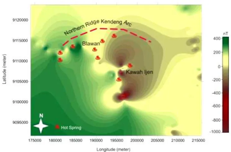
Fig. 4 shows magnetic anomaly maps of the Blawan-Ijen area. In Southwest part, high magnetic anomaly can be easily observed. This anomaly represents the igneous rocks of the Ijen volcano eruption at depth and in turn may indicate the deep heat source for the geothermal activity of the Blawan area. While, low magnetic zone between Blawan and Kawah Ijen can be observed, which might be associated with the destruction of magnetite in the host rocks by hydrothermal alteration.
Based on Pasqua and Massimo (2014) research, the geothermal reservoir at a depth of approximately 2 km and the surface temperature of the hot water that is located in Blawan about 40°C - 55oC. The presence of hot springs around Blawan Ijen, besides due to the lower region also influenced the presence of igneous intrusions Ijen caldera region with a younger age of rocks and carries heat from the volcanic activity. The resulting heat out along with mineral hot springs around Blawan area.
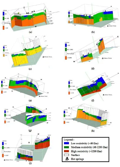
Geoelectric resistivity result data (Fig. 5) show that Blawan area consist of low resistivity values (<40 Ωm) which are interpreted as a hot water layer. Furthermore, the resistivity value between 40-1280 Ωm are interpreted as an aquifer layers and the high resistivity value (>1280 Ωm) are interpreted as
lava rock. Based on resistivity and GPR data known that the underground seepage of hot water in Blawan geothermal field (Fig. 6) are following the fault direction and river flow which evidenced by some hot spring along the Banyupahit river with resistivity value less than 40 Ωm and medium conductivity.
110 P-ISSN:2356-3109 E-ISSN: 2356-3117 Fig. 6. The underground seepage of hot water in Blawan area
Microseismic observation around Blawan-Ijen also clearly outlined that the hot spring rising around the Blawan-Ijen related to the fault zone. This is indicated by high seismicity around the Blawan-Ijen. From the epicenter distribution (Fig. 7) it appears that the source position of the shallow volcanic earthquake and deep volcanic earthquake dominant in distance range around 2 km in the Southeast and Northeast. Local tectonic earthquakes around Mount Ijen occured in a distance about 2-10 km from the crater in the Southeast and Northeast. The epicenter distribution shows the movement of magma from around the crater on the South,
Southeast, East, Northeast and North toward the center of Ijen crater. Prediction of magma migration toward the center of the crater are according to Takano et al (2004) research, which stated that the central activity of Ijen crater is the deepest point in the crater. Additionally, the distribution of microseismicity shows the fracture zone. High seismicity shows the high fracture or fault. These fault structure become the media for fluid circulation from surface to reservoir or from reservoir to surface so the hot spring rice in surface.
Fig. 7. Epicenter distribution of microeartquake event in Blawan-Ijen area
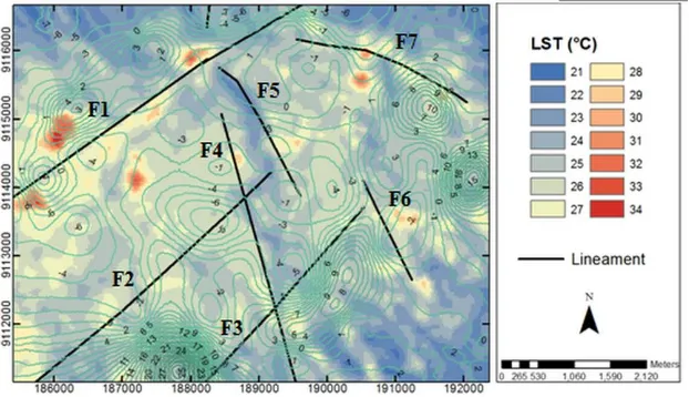
In the other side, the final lineament fault (Fig. 8) from Landsat OLI combined with DEM
springs distribution and also the drainage pattern of the Kalisat at Sempol. The F2 lineament fault is interpreted as a strike slip fault because there is an extreme offset in the Banyupahit River where it crosses the lineament. Dark shading around the Banyupahit river shows the lineament F4 and F5’s fault scarps which both of the faults become a graben. These North - South long scarps have dense contours representing steep slopes with the same inclination.
LST is primarily generated from the total radiation from the Earth’s interior heat and the land surface heat. As the study area has a locally uniform atmosphere, we assume that the atmospheric temperature is constant so it does
not significantly affect the LST estimates (Qin et al., 2011). LST in Blawan area which shown in Fig. 9 is higher than the areas surrounding it, except Ijen crater. The LST for Blawan area is 21°C to 34°C whereas the LST on Ijen complex is 16°C - 40°C while most of the other areas are 21°C - 25°C. Fig. 9 shows that Blawan fault is followed by high LST (red and light orange) and dense contours between positive and negative residual Bouguer anomalies. High densities and positive closure at the north end of the Blawan fault are interpreted as an intrusion heating fluid surrounding the fault and the predicted reservoir. In this case, the Blawan fault is the main structure which controls thermal manifestation in the study area.
Fig. 8. Final lineament fault from Landsat OLI combined with DEM SRTM images
P-ISSN:2356-3109 E-ISSN: 2356-3117 112 Based on the surface manifestation, visual
observation and geophysical observation, the Blawan - Ijen area has a high geothermal potential. Geothermal energy in Blawan - Ijen area can be act as a reserve energy beside biomass, solar and microhydro. Geothermal energy in Blawan - Ijen area can be utilized for geothermal powerplants and also used in industry as a source energy in the coffee drying process. Beside that, the geothermal potential can be used directly for tourism area for local residents and newcomers, so it can increase the local revenue. Blawan - Ijen area will be an attractive conserve area that can provide its own energy for their sustainability and regional development of volcano geothermal region.
Geothermal energy development in Blawan-Ijen area will make an impacts to their sociality, economic and environmental. In this case, the existence of geothermal energy depend on human resources as a key factors or whether such efforts. The principle of geothermal management industry (exploration and exploitation) are high cost of investment, have a high risk (risk of geological, technical, economic, and political uncertainty) and need a modern technology.
4. CONCLUSION
Blawan-Ijen volcano complex has a great geothermal prospect. The heat source of Blawan-Ijen geothermal system predicted to be in the southern part related with high magnetic anomaly, while reservoirs and hydrothermal alteration predicted to be between Blawan and Ijen crater related with the low magnetic anomaly. Geolelectric resistivity, GPR, microseismic and TIR observation clearly outlined that geothermal features such as hot springs at the Blawan-Ijen area occur along lineations providing strong evidence for a fault controlled upflow/outflow of geothermal fluids. Geothermal potential energy in Blawan - Ijen area can be utilized for geothermal powerplants, used in the coffee industry and also for tourism. This high potential of geothermal energy will make Blawan - Ijen be an attractive area that is be able to provide its own energy for their sustainability and regional development of volcano geothermal region.
ACKNOWLEDGEMENTS
Our gratitude to the Directorate General of Higher Education (DIKTI) Republic of Indonesia for their partial supports both in financial and/or facilities under “Hibah Penelitian Unggulan Perguruan Tinggi 2013-2015” and also to USAID project PGA -2000005053.
REFERENCES
Afandi, A.. Maryanto, S and Rachmansyah, A.. 2013. Identifikasi reservoar daerah
panasbumi dengan metode
geomagnetik daerah Blawan, Kecamatan Sempol, Kabupaten Bondowoso. Neutrino, 6(1), 1-10. Carlile, J.C and Mitchell, A.H.G. 1994.
Magmatic arcs and associated gold and copper mineralization in Indonesia.
Journal of Geochemical Exploration, 50(1-3), 91-142.
Claude, N.P., Theopile, N.M., Patrick, A.S., Crepin, K.T. 2014. Evidence of Iron Mineralizaton Channels in the Messondo Area (Centre-Cameroon) using Geoelectrical (DC&IP) Methods : A Case Study. International Journal of Geosciences, vol. 5, pp. 346-361. Coolbaugh, M.F., Kratt, C., Fallacaro, A.,
Calvin, W.M and Taranik, J.V. 2007. Detection of geothermal anomalies using Advanced Spaceborne Thermal Emission and Reflection Radiometer (ASTER) thermal infrared images at Bradys Hot Springs, Nevada, USA.
Remote Sensing of Environment, 106 (3), 350-359.
Foeh, I. M and Rosli, L.R. 2005. Penyelidikan Geomagnetik di Daerah Panas Bumi Kanan Tedong di Desa Pincara
Kecamatan Masamba Kabupaten
Luwu Utara Propinsi Sulawesi Selatan. The exposure of the result activities of geothermal survey. Directorate of Mineral Resources Inventory, Bandung, Indonesia.
Resource Council Annual Meeting, San Diego.
Hendrasto, M. 2006. Gunung Ijen: Pemantauan Seismisitas Gunung Ijen. Center for Volcanology and Geological Hazard Mitigation, Bandung.
Metwaly, M and AlFouzan, F. 1998. Application of 2D Geolectrical Resistivity Tomography for Subsurface Cavity Detection in the Eastern Part of Saudi Arabia.
Geoscience Frontiers, vol. 4, pp. 469-476.
Pasqua, C and Massimo, V. 2014. Remote Sensing Techniques as a Tool for Geothermal Exploration: the Case Study of Blawan Ijen, East Java. EGU General Assembly 2014, April 27 - May 2, Vienna, Austria.
Prabawa, S.E., Taufik, M and Khomsin. 2013. Studi awal pemanfaatan metode GPS geodetik untuk memantau ground deformation sebagai dampak pengembangan lapangan panas bumi. Proceeding National Seminar on Regional Infrastructure Technology Application (ATPW). Surabaya, Indonesia.
Qin, Q., Zhang, N., Nan, P and Chai, L. 2011. Geothermal area detection using landsat ETM+ thermal infrared data and its mechanistic analysis – A case study in Tengchong, China. International Journal of Applied Earth Observation and Geoinformation, 13, 552-559.
Reath, K.A and Ramsey, M.S. 2011. Hyperspectral Thermal Infrared Analysis of the Salton Sea, CA Geothermal Field. AGU Fall Meeting 2011, San Francisco.
Salim, A., Maryanto, S and Purwanto, B.H. 2013. Analisis Gempabumi Mikro (Microearthquakes) di Kompleks Gunung Ijen, Jawa Timur. Physics Student Journal,1(1), 225-228.
Santoso, D.R., Maryanto, S and Wardoyo, A.Y.P. 2012. Development of a simple & low-cost instrumentation system for real time volcano monitoring.
International Journal of Advances in Engineering & Technology, 2(1), 532-542.
Takano, B., Suzuki, K., Sugimori, K., Ohba, T., S.M. Fazlullin., A. Bernard., S. Sumarti., R. Sukhyar and M. Hirabayashi. 2004. Bathymetric and geochemical investigation of Kawah Ijen crater lake, East Java, Indonesia.
Journal of Volcanology and
Geothermal Research, 135, 299-329. Tijani, M.N., Osinowo, O.O. and Ogedengbe,
O. 2009. Mapping of Sub-Surface Fracture Systems using Integrated Electrical Resistivity Profiling and VLF-EM Methods: A Case Study of Suspected Gold Mineralization. RMZ- Materials and Geoenvironment, vol. 56, pp. 415-436.
van Hinsberg, V., Berlo, K., van Bergen, M and Jones, A.W. 2010. Extreme alteration by hyperacidic brines at Kawah Ijen Volcano, East Java, Indonesia:I. Textural and mineralogical imprint. Volcanology and Geothermal Research, 198, 253– 263.
Zaennudin, A., Sumarti, S and Sutaningsih, E.N. 2005. Genetic of an ancient Lake Blawan Ijen Caldera, East Java.
Annual Scientific Meeting of Indonesian Geologists Association.