Open Geospatial Consortium Inc.
Date: 2005-11-03
Reference number of this OGC
®document:
OGC 05-117
Version:
0.0.7
Category: OpenGIS
®Discussion Paper
Editor: Clemens Portele
OWS-3 Schema Maintenance and Tailoring
Copyright notice
Copyright © 2006 Open Geospatial Consortium, Inc. All Rights Reserved.
To obtain additional rights of use, visit http://www.opengeospatial.org/legal/.
Warning
This document is not an OGC Standard. It is distributed for review and comment. It
is subject to change without notice and may not be referred to as an OGC Standard.
Recipients of this document are invited to submit, with their comments, notification
of any relevant patent rights of which they are aware and to provide supporting
documentation.
Document type:
OpenGIS
®Discussion Paper
Document subtype:
OWS IPR Experiment
Document stage:
Approved
Contents
1
Scope...1
2
Conformance ...1
3
Normative references...1
4
Terms and definitions ...2
5
Conventions ...2
5.1
Symbols (and abbreviated terms)...2
5.2
UML Notation ...2
6
Metadata for application schemas...4
6.1
UML Application Schemas ...4
6.1.1
Schema metadata elements ...4
6.1.2
Schema metadata representation ...8
6.2
GML Application Schemas ...14
6.3
Schema metadata representation in the ebRIM Application Profile of
CS-W 2.0 ...17
6.4
Examples for requests to the Catalog Service ...18
6.4.1
Harvesting a GML Application Schema...18
6.4.2
Queryingan application schema ...18
7
Application Schema creation ...20
7.1
Overview ...20
7.2
Application Schema for the NGA Feature Catalog ...20
7.2.1
ISO 19109 Application Schema in UML...20
7.2.2
Dictionaries...28
7.2.3
GML Application Schema...31
7.2.3.1
Overview ...31
7.2.3.2
Using the ShapeChange command line interface...31
7.2.3.3
Using the ShapeChange web interface and Catalog Service client ...32
7.2.4
Known Issues...32
7.2.4.1
Conformance with the proposed GML Profile for Simple Features...32
7.2.4.2
NUNANPO...33
7.2.4.3
Properties with complex values ...36
7.2.4.4
Enumerations ...36
7.2.4.5
Non-linear ranges of allowed values...39
7.2.4.6
Moire 39
7.2.4.7
Multiple imports of Xlink schemas from different locations ...39
7.2.4.8
Categorisations of feature types ...39
7.3
Profile of ISO 19107...40
7.3.2
GML Profile ...40
7.4
Application Schemas for MSD Level 1-3 ...40
7.4.1
ISO 19109 Application Schema in UML...40
7.4.2
Coverages and Themes ...43
7.4.3
Flattened schemas ...47
7.4.4
Other known issues ...48
7.4.5
GML Application Schema...48
i. Submitting
organizations
The following organizations submitted this document to the Open Geospatial Consortium
Inc.:
-
interactive instruments GmbH
ii.
Document Contributor Contact Points
All questions regarding this submission should be directed to the editor or the submitters:
CONTACT COMPANY
Clemens Portele
interactive instruments
Paul Birkel
Mitre
Charles Roswell
NGA
Dave Wesloh
NGA
Wes Kubo
Galdos
Jody Hawkins
Intergraph
James Sullins
CAST
Panagiotis (Peter) Vretanos Cubewerx
David Burggraf
Galdos
Craig Bruce
Cubewerx
Rafael Renkert
interactive instruments
iii. Revision
history
Date Release
Author
Paragraph modified
Description
2005-05-06 0.0.1
CP
First draft (Schema metadata)
2005-05-11 0.0.2
CP
Update (Schema metadata)
2005-05-31 0.0.3
CP
Update (Schema creation)
2005-06-10 0.0.4
CP
Schema metadata changes
2005-10-30 0.0.6
CP
Final
revision
2005-11-03 0.0.7
CP
Number of SAT IPR added (05-121)
2006-04-24 0.0.7
C. Reed
Various
Fix copyright, cover page, etc.
iv.
Changes to the OpenGIS
®
Abstract Specification
Foreword
Introduction
This document contains a description of the schema tailoring process for the application
schema development in the decision support services thread (GeoDSS) during the
OWS-3 initiative. In particular it discusses:
- Metadata describing NGA application schemas to support their discovery and
assessment using CS-W 2.0 services based on the ebXML Registry Information
Model.
- Creation of ISO 19109 Application Schemas in UML for the NSG Feature Catalogue,
MSD Level 1, MSD Level 2, and MSD Level 3
- Derivation of the GML Application Schemas for all four application schemas using
the ShapeChange UML-to-GML-Application-Schema conversion tool
GeoDSS — Schema Maintenance and Tailoring
1 Scope
This OpenGIS
®document describes and discusses the process of creating application
schemas for NGA data. The approach used to create the application schemas starts with
the creation of ISO 19109 application schemas in UML and deriving GML application
schemas from them. It also discusses schema metadata.
2 Conformance
Not required for an IP IPR, DIPR, or Discussion Paper.
3 Normative
references
The following normative documents contain provisions which, through reference in this
text, constitute provisions of this document. For dated references, subsequent
amendments to, or revisions of, any of these publications do not apply. However, parties
to agreements based on this document are encouraged to investigate the possibility of
applying the most recent editions of the normative documents indicated below. For
undated references, the latest edition of the normative document referred to applies.
ISO/TS 19103:2005, Geographic Information – Conceptual Schema Language
ISO 19109:2004, Geographic Information – Rules for Application Schemas
ISO/CD 19136 (February 2004), Geographic Information – Geography Markup
Language (GML)
ISO/TC211/N1784 (April 2005), Geographic Information – Geography Markup
Language (GML)
Catalog Service 2.0, OGC Implementation Specification
ebXML Registry Information Model Application Profile of Catalog Service 2.0, OGC
Recommendation Paper
FACC (NGA Profile), MS Access Database FACC_Manager.mdb, provided by NGA
NGA
MSD Levels 1-3, MS Access Database MSD_Profiles.mdb, provided by NGA
Department of Defense Discovery Metadata Specification (DDMS), Version 1.2,
provided by NGA
DGIWG/TSMAD Profile, Profile(s) of ISO 19107 that support two-dimensional topology
4
Terms and definitions
Not applicable
5 Conventions
5.1
Symbols (and abbreviated terms)
ISO
International Organization for Standardization
OGC
Open Geospatial Consortium
GML
Geography Markup Language
UML
Unified Modeling Language
XML
eXtended Markup Language
1D One
Dimensional
2D Two
Dimensional
3D Three
Dimensional
NGA
National Geospatial Intelligence Agency
FACC
Feature and Attribute Coding Catalogue
DIGEST
Digital Geographic Information Exchange Standard
MSD
Mission Specific Data
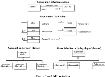
5.2 UML
Notation
The UML notations used in this document are described in the diagram below.
Association between classes
role-1 role-2 Association Name
Class #1 Class #2
Association Cardinality
Class
Only one
Class
Zero or more
Class
Optional (zero or one ) 1..*
Class
One or more
n Class
Specific number
Aggregation between classes
Aggregate Class
Component
Class #1 ComponentClass #2 ComponentClass #n
………. 0..*
0..1
Class Inheritance (subtyping of classes)
Superclass
Subclass #1
…………..
Subclass #2 Subclass #n
Figure 1 — UML notation
In the class diagrams, the following stereotypes of UML classes are used:
a) <<DataType>> A descriptor of a set of values that lack identity (independent
existence and the possibility of side effects). A DataType is a class with no
operations whose primary purpose is to hold the information.
b) <<BasicType>> A special type of a DataType that typically has a canonical
representation in a computing platform, in this case XML Schema.
c) <<CodeList>> is a flexible enumeration that uses string values for expressing a list of
potential values.
d) <<Enumeration>> is a fixed list of valid identifiers of named literal values. Attributes
of an enumerated type can only take values from this list.
e) <<Union>> is a list of attributes. The semantics is that only one of the attributes can
be present at any time.
In this document, the following standard basic data types are used:
a) CharacterString – A sequence of characters
c) Real – A floating point number
d) Boolean – A boolean value (true or false)
6
Metadata for application schemas
6.1
UML Application Schemas
6.1.1
Schema metadata elements
The Catalog Service 2.0 Implementation Specification specifies the following list of
"core queryable properties" (see Catalog Service 2.0, 6.3.2, for the definition of the
properties). The following table specifies their interpretation in the context of OWS-3
application schemas and in particular the mapping to the DDMS metadata specification
and the representation in a UML application schema:
Table 1 — Core queryable properties for UML Application Schemas
Property DDMS
Primary
Category
Representation in UML
Subject Subject
(Mandatory)
Tagged value "Subject" of the package representing the application schema
The content shall be a comma seperated list of values from either the default
MD_TopicCategoryCode codelist from ISO 19115, i.e.
- farming
- biota
- boundaries
- climatologyMeteorologyAtmosphere
- economy
- elevation
- environment
- geoscientificInformation
- health
- imageryBaseMapsEarthCover
- intelligenceMilitary
- inlandWaters
- location
- oceans
- planningCadastre
- society
- structure
- transportation
- utilitiesCommunication
- culture
- hydrography
- hypsography
- physiography
- vegetation
- demarcation
- aeronauticalInformation
- cadastral
- czechNational
- routesSpecial
- specialUse
- general
In addition, additional values shall be specified, where applicable, for the Level of
the Applciation Schema:
- MSD1
- MSD2
- MSD3
- MSD4
- MSD5
Note: These values shall be mapped in the Catalog Service into classifications. The
three classifications (ISO 19115, FACC, MSD-Level) shall be maintained
seperately in the Catalog Service.
To distinguish between the three vocabularies, the following codespace quialifiers
shall be used:
- http://www.isotc211.org/2005/gmd/MD_TopicCategoryCode
- http://www.dgiwg.org/dfdd/category
- http://www.nga.mil/
Title Title
(Mandatory)
Name of the package representing the application schema
Abstract Description
(Optional)
Documentation of the package representing the application schema
AnyText
(not
used)
Format Format
(Optional)
Codelist values are
- text/xml;
subtype="xmi/1.0"
This value is used for a UML model that does not follow the stricter rules
specified by ISO 19109 and/or ISO 19136
- text/xml;
subtype="xmi/1.0/iso19109"
This value is used for a UML application schema that does not follow the
rules specified by ISO 19109, but not the stricter rules specified by ISO 19136
Annex E
- text/xml;
subtype="xmi/1.0/iso19136"
This value is used for a UML application schema that does follow the rules
specified by ISO 19136 Annex E
In OWS-3 all application schemas will be schemas of the format 'text/xml;
subtype="xmi/1.0/iso19136"'.
Identifier Identifier
be the string "urn:uuid:" followed by the hexadecimal representation of a UUID.
Example: "urn:uuid:f81d4fae-7dec-11d0-a765-00a0c91e6bf6"
The Identifier value shall change with every new version of the application
schema.
Modified Date
(Optional)
Tagged value "Modified" of the package representing the application schema
The content shall be specified as "YYYY-MM-DD"
Type Type
(Optional)
Allowed codelist values are:
- Schema
This value is used for schema metadata for an application schema
- FeatureType
This value is used for schema metadata for a feature type
In OWS-3 schema metadata is mandatory for all application schemas and feature
types.
Envelope Geospatial
Coverage,
Temporal
Coverage
(not used)
CRS
(not used)
Association
The following associations are used:
derivedFrom:
Schema/FeatureType resource
is derived from
Schema/FeatureType
resource
(not used in UML)
dependsOn:
Schema resource
depends on
Schema resource
(UML dependency
relationsships between packages representing application schemas)
resource:
Schema/FeatureType resource
is available at
URL
(location of the XMI
document or the element in the XMI document representing the class resepctively)
partOfApplicationSchema:
FeatureType resource
is part of
Schema resource
(containment of a feature type class in a package representing the application
schema)
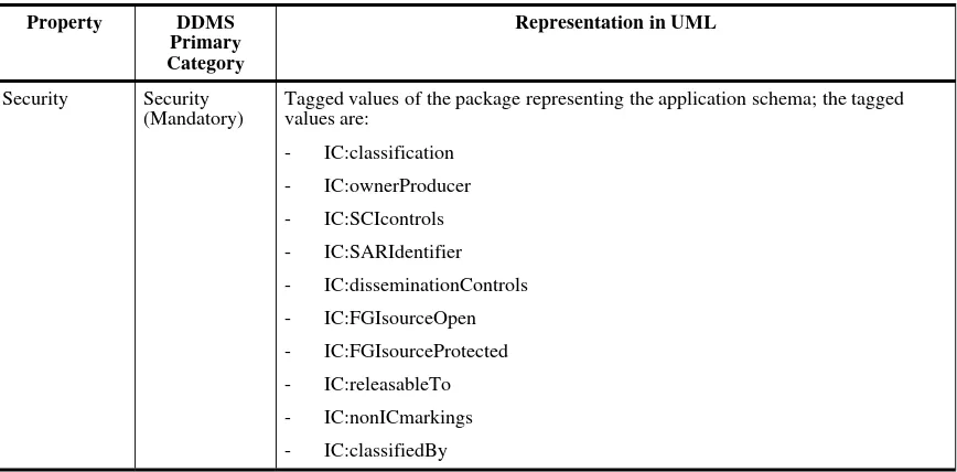
Table 2 — Additional queryable properties for UML Application Schemas
Property DDMS
Primary
Category
Representation in UML
Security Security
(Mandatory)
Tagged values of the package representing the application schema; the tagged
values are:
- IC:classification
- IC:ownerProducer
- IC:SCIcontrols
- IC:SARIdentifier
- IC:disseminationControls
- IC:FGIsourceOpen
- IC:FGIsourceProtected
- IC:releasableTo
- IC:nonICmarkings
- IC:classificationReason
- IC:derivedFrom
- IC:declassDate
- IC:declassEvent
- IC:declassException
- IC:typeOfExemptedSource
- IC:dateOfExemptedSource
- IC:declassManualReview
The values are used to populate XML attribute instances of the following XML
Schema definitions from the Intelligence Community Information Security
Marking (IC ISM) Version 2.0 as the authoritative implementation of CAPCO:
- urn:us:gov:ic:ism:v2:SecurityAttributesOptionGroup
The values therefore shall conform to the rules of this specification.
The value of "IC:classification" shall be stored in the Catalog Service as a
classification. The allowed values for this classification by IC ISM are:
- U
- C
- S
- TS
- R
- CTS
- CTS-B
- CTS-BALK
- NU
- NR
- NC
- NS
- NS-S
- NS-A
- CTSA
- NSAT
- NCA
Creator Creator
(Mandatory)
Tagged Value "Creator" of the package representing the application schema
Publisher Publisher
(Optional)
Tagged Value "Publisher" of the package representing the application schema
Other optional DDMS categories exist (Contributor, Rights, Language, Source) and may
be added if required.
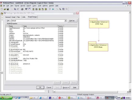
Figure 2 — Application Schema "OWS Test"
The XMI representation of this simple schema is (exported from Rational Rose) shown in
file OWSTest.xml.
6.1.2
Schema metadata representation
To make the schema metadata properties available to the Catalog Service, three principal
options exist:
1. Specification of Xpath expressions to the information within the XML resource (the
XMI document)
2. Specification of a proxy XML resource containing these properties so they can be
accessed by simple Xpath expressions
3. Maintaining the resource information in the Catalog "manually" using explicit
transactions
Subject:
//Foundation.Extension_Mechanisms.TaggedValue.value[ ../Foundation.Extension_Mechanisms.TaggedValue.tag = "RationalRose$ShapeChange:Subject" and
../Foundation.Extension_Mechanisms.TaggedValue.modelElement/ Foundation.Core.ModelElement/@xmi.idref =
//Model_Management.Package[./Foundation.Core.ModelElement.name=$asname]/@xmi.id ]
Title:
//Model_Management.Package[./Foundation.Core.ModelElement.name=$asname]/Foundation.Core.M odelElement.name
Abstract
//Foundation.Extension_Mechanisms.TaggedValue.value[
../Foundation.Extension_Mechanisms.TaggedValue.tag = "documentation" and ../Foundation.Extension_Mechanisms.TaggedValue.modelElement/
Foundation.Core.ModelElement/@xmi.idref =
//Model_Management.Package[./Foundation.Core.ModelElement.name=$asname]/@xmi.id ]
Format
Fixed value: text/xml; subtype="xmi/1.0/iso19136"
Identifier
//Foundation.Extension_Mechanisms.TaggedValue.value[ ../Foundation.Extension_Mechanisms.TaggedValue.tag = "RationalRose$ShapeChange:Idenifier" and
../Foundation.Extension_Mechanisms.TaggedValue.modelElement/ Foundation.Core.ModelElement/@xmi.idref =
//Model_Management.Package[./Foundation.Core.ModelElement.name=$asname]/@xmi.id ]
Modified
//Foundation.Extension_Mechanisms.TaggedValue.value[ ../Foundation.Extension_Mechanisms.TaggedValue.tag = "RationalRose$ShapeChange:Modified" and
../Foundation.Extension_Mechanisms.TaggedValue.modelElement/ Foundation.Core.ModelElement/@xmi.idref =
//Model_Management.Package[./Foundation.Core.ModelElement.name=$asname]/@xmi.id ]
Type
Fixed value: Schema
Association "dependsOn"
//Foundation.Extension_Mechanisms.TaggedValue.value[ ../Foundation.Extension_Mechanisms.TaggedValue.tag = "RationalRose$ShapeChange:Identifier" and
../Foundation.Extension_Mechanisms.TaggedValue.modelElement/ Foundation.Core.ModelElement/@xmi.idref =
//Model_Management.Package[
./@xmi.id=//Foundation.Core.Dependency.supplier[
]/@xmi.id ]
If such Xpath expressions can be supported by the Catalog Service(s), then this option
would in principle be the preferred approach. However, taking into account that support
for the various XMI dialects exported by different UML tools would require even more
complex Xpath expressions, the risks associated with the approach do not seem justified.
Therefore, an approach using a proxy resource (option 2) should be applied. An example
resource file consisting of one schema resource and multiple feature type resources would
be:
<Resource xmlns="http://metadata.dod.mil/mdr/ns/DDMS/1.2/"><identifier ddms:qualifier="urn:uuid" ddms:value="c03321f1-8129-404f-9d2c-e1ebc2cc34bc"/>
<title ICISM:classification="U" ICISM:ownerProducer="USA">MSD Level 3</title> <subtitle ICISM:classification="U" ICISM:ownerProducer="USA">Version 0.4_2005-04-01</subtitle>
<description ICISM:classification="U" ICISM:ownerProducer="USA">MSD Level 3 application schema. Automatically created from the NGA Access Databases (FACC/DFDD, NGA Feature Catalogue and Mission Specific Data).</description>
<language ddms:qualifier="ISO 639-1" ddms:value="en"/> <dates ddms:created="2005-07-27"/>
<rights ddms:copyright="true"/> <type ddms:value="Schema"/>
<creator ICISM:classification="U" ICISM:ownerProducer="USA"> <Organization>
<name>interactive instruments GmbH</name> <phone>+49-228-91410-70</phone>
<email>[email protected]</email> </Organization>
</creator>
<publisher ICISM:classification="U" ICISM:ownerProducer="USA"> <Organization>
<name>NGA</name>
<phone>+1-703-814-4580</phone> <email>[email protected]</email> </Organization>
</publisher> <format> <Media>
<mimeType>text/xml; subtype="xmi/1.0/iso19136"</mimeType> <extent/>
<medium>digital</medium> </Media>
</format>
<subjectCoverage> <Subject>
<category ddms:label="MSD3" ddms:qualifier="http://www.nga.mil/"/> <category ddms:label="culture"
<category ddms:label="aeronauticalInformation" ddms:qualifier="http://www.dgiwg.org/dfdd/category"/>
<category ddms:label="specialUse" ddms:qualifier="http://www.dgiwg.org/dfdd/category"/> <category ddms:label="general"
ddms:qualifier="http://www.dgiwg.org/dfdd/category"/> <category ddms:label="farming"
ddms:qualifier="http://www.isotc211.org/2005/gmd/MD_TopicCategoryCode"/> <category ddms:label="biota"
ddms:qualifier="http://www.isotc211.org/2005/gmd/MD_TopicCategoryCode"/> <category ddms:label="boundaries"
ddms:qualifier="http://www.isotc211.org/2005/gmd/MD_TopicCategoryCode"/> <category ddms:label="economy"
ddms:qualifier="http://www.isotc211.org/2005/gmd/MD_TopicCategoryCode"/> <category ddms:label="elevation"
ddms:qualifier="http://www.isotc211.org/2005/gmd/MD_TopicCategoryCode"/> <category ddms:label="environment"
ddms:qualifier="http://www.isotc211.org/2005/gmd/MD_TopicCategoryCode"/> <category ddms:label="geoscientificInformation"
ddms:qualifier="http://www.isotc211.org/2005/gmd/MD_TopicCategoryCode"/> <category ddms:label="health"
ddms:qualifier="http://www.isotc211.org/2005/gmd/MD_TopicCategoryCode"/> <category ddms:label="intelligenceMilitary"
ddms:qualifier="http://www.isotc211.org/2005/gmd/MD_TopicCategoryCode"/> <category ddms:label="inlandWaters"
ddms:qualifier="http://www.isotc211.org/2005/gmd/MD_TopicCategoryCode"/> <category ddms:label="location"
ddms:qualifier="http://www.isotc211.org/2005/gmd/MD_TopicCategoryCode"/> <category ddms:label="oceans"
ddms:qualifier="http://www.isotc211.org/2005/gmd/MD_TopicCategoryCode"/> <category ddms:label="society"
ddms:qualifier="http://www.isotc211.org/2005/gmd/MD_TopicCategoryCode"/> <category ddms:label="structure"
ddms:qualifier="http://www.isotc211.org/2005/gmd/MD_TopicCategoryCode"/> <category ddms:label="transportation"
ddms:qualifier="http://www.isotc211.org/2005/gmd/MD_TopicCategoryCode"/> <category ddms:label="utilitiesCommunication"
ddms:qualifier="http://www.isotc211.org/2005/gmd/MD_TopicCategoryCode"/>
<security ICISM:classification="U" ICISM:ownerProducer="USA"/> <relations xmlns="http://www.opengis.net/ows3/geodss/schemametadata"> <relation
xlink:href="urn:uuid:75cbe865-0453-4989-8aa0-91504fa4116d">dependsOn</relation>
<relation
xlink:href="http://www.interactive-instruments.de/ows3/repository/xmi/msd3.xml">resource</relation> </relations>
</Resource>
<Resource xmlns="http://metadata.dod.mil/mdr/ns/DDMS/1.2/">
<identifier ddms:qualifier="urn:uuid" ddms:value="85bbc5c1-a387-4572-a76e-bfd2c30aa249"/>
<title ICISM:classification="U" ICISM:ownerProducer="USA">AFA012</title> <subtitle ICISM:classification="U" ICISM:ownerProducer="USA">Version 0.4_2005-04-01</subtitle>
<description ICISM:classification="U" ICISM:ownerProducer="USA">Contaminated Area: An area which has been exposed to Nuclear, Biological or Chemical (NBC)
agents.</description>
<language ddms:qualifier="ISO 639-1" ddms:value="en"/> <dates ddms:created="2005-07-27"/>
<rights ddms:copyright="true"/> <type ddms:value="FeatureType"/>
<creator ICISM:classification="U" ICISM:ownerProducer="USA"> <Organization>
<name>interactive instruments GmbH</name> <phone>+49-228-91410-70</phone>
</creator>
<publisher ICISM:classification="U" ICISM:ownerProducer="USA"> <Organization>
<name>NGA</name>
<phone>+1-703-814-4580</phone> <email>[email protected]</email> </Organization>
</publisher> <format> <Media>
<mimeType>text/xml; subtype="xmi/1.0/iso19136"</mimeType> <extent/>
<medium>digital</medium> </Media>
</format>
<subjectCoverage> <Subject>
<keyword ddms:value="AFA012"/>
<keyword ddms:value="Contaminated Area"/> </Subject>
</subjectCoverage> <geospatialCoverage> <Place/>
</geospatialCoverage>
<security ICISM:classification="U" ICISM:ownerProducer="USA"/> <relations xmlns="http://www.opengis.net/ows3/geodss/schemametadata"> <relation
xlink:href="urn:uuid:c03321f1-8129-404f-9d2c-e1ebc2cc34bc">partOfApplicationSchema</relation> <relation
xlink:href="http://www.interactive-instruments.de/ows3/repository/xmi/msd3.xml#element(//Foundation.Core.Class[Foundation.Co re.ModelElement.name='AFA012'])">resource</relation>
</relations> </Resource>
<Resource xmlns="http://metadata.dod.mil/mdr/ns/DDMS/1.2/">
<identifier ddms:qualifier="urn:uuid" ddms:value="27d50902-6ecd-4f78-ab5b-6fcc764d95b7"/>
<title ICISM:classification="U" ICISM:ownerProducer="USA">AAQ140</title> <subtitle ICISM:classification="U" ICISM:ownerProducer="USA">Version 0.4_2005-04-01</subtitle>
<description ICISM:classification="U" ICISM:ownerProducer="USA">US-Vehicle Storage/Parking Area UK-Vehicle Storage/Parking Area/Car Park/Boat Park: An open land area used for storing or parking vehicles or vessels (including recreational vehicles). (See also AI020 and AK060)</description>
<language ddms:qualifier="ISO 639-1" ddms:value="en"/> <dates ddms:created="2005-07-27"/>
<rights ddms:copyright="true"/> <type ddms:value="FeatureType"/>
<creator ICISM:classification="U" ICISM:ownerProducer="USA"> <Organization>
<name>interactive instruments GmbH</name> <phone>+49-228-91410-70</phone>
<email>[email protected]</email> </Organization>
</creator>
<publisher ICISM:classification="U" ICISM:ownerProducer="USA"> <Organization>
<name>NGA</name>
<phone>+1-703-814-4580</phone> <email>[email protected]</email> </Organization>
</publisher> <format> <Media>
<mimeType>text/xml; subtype="xmi/1.0/iso19136"</mimeType> <extent/>
<medium>digital</medium> </Media>
</format>
<subjectCoverage> <Subject>
<keyword ddms:value="US-Vehicle Storage/Parking Area UK-Vehicle Storage/Parking Area/Car Park/Boat Park"/>
</Subject> </subjectCoverage> <geospatialCoverage> <Place/>
</geospatialCoverage>
<security ICISM:classification="U" ICISM:ownerProducer="USA"/> <relations xmlns="http://www.opengis.net/ows3/geodss/schemametadata"> <relation
xlink:href="urn:uuid:c03321f1-8129-404f-9d2c-e1ebc2cc34bc">partOfApplicationSchema</relation> <relation
xlink:href="http://www.interactive-instruments.de/ows3/repository/xmi/msd3.xml#element(//Foundation.Core.Class[Foundation.Co
The schema sm.xsd specifying the schema metadata used, i.e. the additions to DDMS is:
<xs:schema targetNamespace="http://www.opengis.net/ows3/geodss/schemametadata"
<xs:import namespace="http://www.w3.org/1999/xlink" schemaLocation="../xlink/xlinks.xsd"/>
<xs:element name="relation" substitutionGroup="dc:relation"> <xs:complexType>
<xs:complexContent>
<xs:extension base="dc:SimpleLiteral">
<xs:attributeGroup ref="xlink:simpleLink"/> </xs:extension>
</xs:complexContent> </xs:complexType> </xs:element>
<xs:element name="relations"> <xs:complexType>
<xs:sequence>
<xs:element ref="relation" minOccurs="0" maxOccurs="unbounded"/> </xs:sequence>
</xs:complexType> </xs:element>
<xs:element name="Resources"> <xs:complexType>
<xs:sequence>
<xs:element ref="ddms:Resource" minOccurs="0" maxOccurs="unbounded"/> </xs:sequence>
</xs:complexType> </xs:element>
</xs:schema>
Option 3 should be avoided to make use of the capabilities of the Catalog Services to
harvest the properties from well-known resources.
6.2
GML Application Schemas
The same schema information specified for the UML application schemas shall also be
available for the GML Application Schemas. Information the original UML application
schema shall be added.
The standard way of encoding the schema metadata in a GML Application Schema in
OWS-3 is by embedding the metadata information in an appinfo annotation of the
<schema> element of the root XML Schema document of the application schema. For
example:
<Resources xmlns:ICISM="urn:us:gov:ic:ism:v2" xmlns:dc="http://purl.org/dc/elements/1.1/" <Resource xmlns="http://metadata.dod.mil/mdr/ns/DDMS/1.2/">
<identifier ddms:qualifier="urn:uuid" ddms:value="02d45a51-bc39-49c2-9973-03b427cdc17d"/>
<title ICISM:classification="U" ICISM:ownerProducer="USA">MSD Level 3</title>
<subtitle ICISM:classification="U" ICISM:ownerProducer="USA">Version 0.4_2005-04-01</subtitle>
<description ICISM:classification="U" ICISM:ownerProducer="USA">MSD Level 3 application schema. Automatically created from the NGA Access Databases (FACC/DFDD, NGA Feature Catalogue and Mission Specific Data).</description>
<language ddms:qualifier="ISO 639-1" ddms:value="en"/> <dates ddms:created="2005-07-27"/>
<rights ddms:copyright="true"/> <type ddms:value="Schema"/>
<creator ICISM:classification="U" ICISM:ownerProducer="USA"> <Organization>
<name>interactive instruments GmbH</name> <phone>+49-228-91410-70</phone>
<email>[email protected]</email> </Organization>
</creator>
<publisher ICISM:classification="U" ICISM:ownerProducer="USA"> <Organization>
<name>NGA</name>
<phone>+1-703-814-4580</phone> <email>[email protected]</email> </Organization>
</publisher> <format> <Media>
<mimeType>text/xml; subtype="gmlas/3.1.1"</mimeType> <extent/>
<medium>digital</medium> </Media>
</format>
<subjectCoverage> <Subject>
<category ddms:label="MSD3" ddms:qualifier="http://www.nga.mil/"/> <category ddms:label="culture"
ddms:qualifier="http://www.dgiwg.org/dfdd/category"/> <category ddms:label="hypsography" ddms:qualifier="http://www.dgiwg.org/dfdd/category"/> <category ddms:label="physiography" ddms:qualifier="http://www.dgiwg.org/dfdd/category"/> <category ddms:label="vegetation" ddms:qualifier="http://www.dgiwg.org/dfdd/category"/> <category ddms:label="demarcation" ddms:qualifier="http://www.dgiwg.org/dfdd/category"/>
<category ddms:label="aeronauticalInformation" ddms:qualifier="http://www.dgiwg.org/dfdd/category"/>
<category ddms:label="specialUse" ddms:qualifier="http://www.dgiwg.org/dfdd/category"/> <category ddms:label="boundaries"
ddms:qualifier="http://www.isotc211.org/2005/gmd/MD_TopicCategoryCode"/> <category ddms:label="economy"
ddms:qualifier="http://www.isotc211.org/2005/gmd/MD_TopicCategoryCode"/> <category ddms:label="elevation"
ddms:qualifier="http://www.isotc211.org/2005/gmd/MD_TopicCategoryCode"/> <category ddms:label="environment"
ddms:qualifier="http://www.isotc211.org/2005/gmd/MD_TopicCategoryCode"/> <category ddms:label="geoscientificInformation" ddms:qualifier="http://www.isotc211.org/2005/gmd/MD_TopicCategoryCode"/> <category ddms:label="health"
ddms:qualifier="http://www.isotc211.org/2005/gmd/MD_TopicCategoryCode"/> <category ddms:label="intelligenceMilitary" ddms:qualifier="http://www.isotc211.org/2005/gmd/MD_TopicCategoryCode"/> <category ddms:label="inlandWaters"
ddms:qualifier="http://www.isotc211.org/2005/gmd/MD_TopicCategoryCode"/> <category ddms:label="transportation"
ddms:qualifier="http://www.isotc211.org/2005/gmd/MD_TopicCategoryCode"/> <category ddms:label="utilitiesCommunication" ddms:qualifier="http://www.isotc211.org/2005/gmd/MD_TopicCategoryCode"/> </Subject>
</subjectCoverage> <geospatialCoverage> <Place/>
</geospatialCoverage>
<security ICISM:classification="U" ICISM:ownerProducer="USA"/>
<relations xmlns="http://www.opengis.net/ows3/geodss/schemametadata"> <relation
xlink:href="urn:uuid:96284A9E-8074-44E2-AF99-012771B4963F">derivedFrom</relation>
<relation xlink:href="urn:uuid:c4a0f991-fe30-4e5f-9da3-f7b986885aaf">dependsOn</relation>
<relation xlink:href="./MSD3.xsd">resource</relation> </relations>
</Resource>
<Resource xmlns="http://metadata.dod.mil/mdr/ns/DDMS/1.2/">
<identifier ddms:qualifier="urn:uuid" ddms:value="7f269990-c0fb-4a3b-b51c-3342a4607bb2"/>
<title ICISM:classification="U" ICISM:ownerProducer="USA">AFA012</title> <subtitle ICISM:classification="U" ICISM:ownerProducer="USA">Version 0.4_2005-04-01</subtitle>
<description ICISM:classification="U"
ICISM:ownerProducer="USA">Contaminated Area: An area which has been exposed to Nuclear, Biological or Chemical (NBC) agents.</description>
<dates ddms:created="2005-07-27"/> <rights ddms:copyright="true"/> <type ddms:value="FeatureType"/>
<creator ICISM:classification="U" ICISM:ownerProducer="USA"> <Organization>
<name>interactive instruments GmbH</name> <phone>+49-228-91410-70</phone>
<email>[email protected]</email> </Organization>
</creator>
<publisher ICISM:classification="U" ICISM:ownerProducer="USA"> <Organization>
<name>NGA</name>
<phone>+1-703-814-4580</phone> <email>[email protected]</email> </Organization>
</publisher> <format> <Media>
<mimeType>text/xml; subtype="gmlas/3.1.1"</mimeType> <extent/>
<medium>digital</medium> </Media>
</format>
<subjectCoverage> <Subject>
<keyword ddms:value="AFA012"/>
<keyword ddms:value="Contaminated Area"/> </Subject>
</subjectCoverage> <geospatialCoverage> <Place/>
</geospatialCoverage>
<security ICISM:classification="U" ICISM:ownerProducer="USA"/>
<relations xmlns="http://www.opengis.net/ows3/geodss/schemametadata"> <relation
xlink:href="urn:uuid:02d45a51-bc39-49c2-9973-03b427cdc17d">partOfApplicationSchema</relation>
<relation xmlns:xs="http://www.w3.org/2001/XMLSchema"
xlink:href="./MSD3.xsd#element(//xs:element[@name='AFA012'])">resource</relation> </relations>
</Resource>
<Resource xmlns="http://metadata.dod.mil/mdr/ns/DDMS/1.2/">
<identifier ddms:qualifier="urn:uuid" ddms:value="f8203a2b-1a89-4471-adbe-804b0e3eba46"/>
<title ICISM:classification="U" ICISM:ownerProducer="USA">AAQ140</title> <subtitle ICISM:classification="U" ICISM:ownerProducer="USA">Version 0.4_2005-04-01</subtitle>
<description ICISM:classification="U" ICISM:ownerProducer="USA">US-Vehicle Storage/Parking Area UK-Vehicle Storage/Parking Area/Car Park/Boat Park: An open land area used for storing or parking vehicles or vessels (including recreational vehicles). (See also AI020 and AK060)</description>
<language ddms:qualifier="ISO 639-1" ddms:value="en"/> <dates ddms:created="2005-07-27"/>
<rights ddms:copyright="true"/> <type ddms:value="FeatureType"/>
<creator ICISM:classification="U" ICISM:ownerProducer="USA"> <Organization>
<name>interactive instruments GmbH</name> <phone>+49-228-91410-70</phone>
<email>[email protected]</email> </Organization>
</creator>
<publisher ICISM:classification="U" ICISM:ownerProducer="USA"> <Organization>
<name>NGA</name>
<phone>+1-703-814-4580</phone> <email>[email protected]</email> </Organization>
<mimeType>text/xml; subtype="gmlas/3.1.1"</mimeType> <extent/>
<medium>digital</medium> </Media>
</format>
<subjectCoverage> <Subject>
<keyword ddms:value="AAQ140"/>
<keyword ddms:value="US-Vehicle Storage/Parking Area UK-Vehicle Storage/Parking Area/Car Park/Boat Park"/>
</Subject> </subjectCoverage> <geospatialCoverage> <Place/>
</geospatialCoverage>
<security ICISM:classification="U" ICISM:ownerProducer="USA"/>
<relations xmlns="http://www.opengis.net/ows3/geodss/schemametadata"> <relation
xlink:href="urn:uuid:02d45a51-bc39-49c2-9973-03b427cdc17d">partOfApplicationSchema</relation>
<relation xmlns:xs="http://www.w3.org/2001/XMLSchema"
xlink:href="./MSD3.xsd#element(//xs:element[@name='AAQ140'])">resource</relation> </relations>
</Resource>
<!-- … more feature types --> </Resources>
</appinfo>
<documentation>MSD Level 3 application schema. Automatically created from the NGA Access Databases (FACC/DFDD, NGA Feature Catalogue and Mission Specific
Data).</documentation> </annotation>
<import namespace="http://www.interactive-instruments.de/ShapeChange" schemaLocation="ShapeChangeAppinfo.xsd"/>
<import namespace="http://www.opengis.net/gml" schemaLocation="base/gml3NGAProfile.xsd"/>
<!-- ... --> </schema>
In principle, in cases where the schema cannot be edited to add the schema metadata, a
proxy resource may be used like in the UML/XMI case. In either case, a relation
"resource" shall be part of the resource description pointing to the root schema document
of the GML application schema or the element definition of the feature type.
The code list of allowed format values is:
- text/xml;
subtype="gmlas/2.1.2"
- text/xml;
subtype="gmlas/3.0.0"
- text/xml;
subtype="gmlas/3.0.1"
- text/xml;
subtype="gmlas/3.1.0"
- text/xml;
subtype="gmlas/3.1.1"
- text/xml;
subtype="gmlas/3.1.1/sfgml"
6.3
Schema metadata representation in the ebRIM Application Profile of CS-W 2.0
6.4
Examples for requests to the Catalog Service
6.4.1
Harvesting a GML Application Schema
<Harvest xmlns="http://www.opengis.net/csw"
xmlns:xsi="http://www.w3.org/2001/XMLSchema-6.4.2
Queryingan application schema
The following query searches the catalog for all schemas and feature types that have the
word "Mine" in their title, subtitle or description. Note that the OWS-3 extension
"matchCase='false'" is used to make the search not case-sensitive.
<GetRecords xmlns="http://www.opengis.net/csw" xmlns:ogc="http://www.opengis.net/ogc" <Query typeNames="csw:Record">
<ElementSetName>full</ElementSetName> <Constraint>
<ogc:Filter> <ogc:Or>
<ogc:PropertyIsLike wildCard="%" singleChar="_" escape="\" matchCase="false">
<ogc:PropertyName>/csw:Record/dc:alternative</ogc:PropertyName> <ogc:Literal>%Mine%</ogc:Literal>
</ogc:PropertyIsLike>
<ogc:PropertyIsLike wildCard="%" singleChar="_" escape="\" matchCase="false">
<ogc:PropertyName>/csw:Record/dc:description</ogc:PropertyName> <ogc:Literal>%Mine%</ogc:Literal>
</ogc:PropertyIsLike>
<ogc:PropertyIsLike wildCard="%" singleChar="_" escape="\" matchCase="false">
<ogc:PropertyName>/csw:Record/dc:title</ogc:PropertyName> <ogc:Literal>%Mine%</ogc:Literal>
</ogc:PropertyIsLike> </ogc:Or>
</ogc:Filter> </Constraint> </Query>
</GetRecords>
A query for requesting a brief result set (other supported values are summary and full):
<GetRecords xmlns="http://www.opengis.net/csw" xmlns:ogc="http://www.opengis.net/ogc"
<ogc:Filter>
<ogc:PropertyIsEqualTo>
<ogc:PropertyName>/csw:Record/dc:publisher</ogc:PropertyName> <ogc:Literal>NGA</ogc:Literal>
The following query illustrates queries on associations. Here, it searches for all resources
that have an association with a resource that is located at a URL that contains
"interactive-instruments.de":
<ogc:PropertyIsEqualTo>
<ogc:PropertyName>/Association/@targetObject</ogc:PropertyName> <ogc:PropertyName>/ExternalLink/@id</ogc:PropertyName>
</ogc:PropertyIsEqualTo>
<ogc:PropertyIsLike wildCard="%" singleChar="_" escape="\">
<ogc:PropertyName>/ExternalLink/@externalURI</ogc:PropertyName> <ogc:Literal>%interactive-instruments.de%</ogc:Literal>
</ogc:PropertyIsLike> </ogc:And>
</ogc:Filter> </csw:Constraint> </csw:Query>
</csw:GetRecords>
There are issues with the schema metadata and their CS-W mapping. While the schema
metadata is harvested as DDMS metadata elements, the CS-W returns the metadata
elements as mapped to the CS-W and ebXML RIM elements. This is not without side
effects. Two examples:
- The <ddms:createor> has three sub elements for an organization: name, phone, and
email. However, the CS-W core queryable property is just a text string so
<creator ICISM:classification="U" ICISM:ownerProducer="USA"> <Organization>
<name>interactive instruments GmbH</name> <phone>+49-228-91410-70</phone>
<email>[email protected]</email> </Organization>
</creator>
ends up in a CS-W response as
- While DDMS has an element <ddms:subtitle> this is mapped to <dc:alternative>
because there is no subtitle element in the CS-W core queryable properties which
may not be what a CS-W client user expects.
7
Application Schema creation
7.1 Overview
Based on existing data specifications used by NGA, a number of application schemas
were created. These application schemas were developed as ISO 19109 application
schemas in UML and as GML application schemas (using GML version 3.1, ISO CD
19136). These are:
-
a NGA profile of the FACC (NGA Feature Catalog)
-
product application schemas for MSD Levels 1, 2 and 3
Since the application schemas are large in terms of the number of feature type and
attribute definitions, the schemas were created automatically based on the processes
developed in the OWS-2 initiative:
Basic
Step (1) was executed using a script creating a Rational Rose UML model from the input
descriptions provided by NGA. This script was implemented in Visual Basic.
Step (2) was executed using the Open Source UGAS tool “ShapeChange” of interactive
instruments. More information about the tool including documentation can be found in
document 05-117 and at http://www.interactive-instruments.de/ugas/. The tool
documentation includes one document describing the mapping rules from UML to GML
as implemented by the tool plus a second document describing the implementation of the
ShapeChange tool, its installation and guidelines for using the tool.
7.2
Application Schema for the NGA Feature Catalog
7.2.1
ISO 19109 Application Schema in UML
The NGA Feature Catalog application schema is created from the MS Access databases
maintained by Rex Buckley at NGA (NGA_Feature_Catalog.mdb, using the master table
dated April 1
st, 2005 and FACC_Manager.mdb in the version 2003-02).
FACC data dictionary that are used in the NGA Feature Catalog.
In order to process these input databases a Visual Basic program was developed
implementing the required steps to convert the NGA Feature Catalog to a UML
Application Schema in Rational Rose. The DAO interface was used to acccess the MS
Access databases and the Rational Rose COM Interface was used to create the objects in
Rational Rose. At the same time, the GML Dictionaries for the Feature Type names, the
Attribute Type names and the Attribute Code descriptions were created by the program.
In its first step, the following UML packages were created by the program:
-
A root package for the NGA Feature Catalog (stereotype <<Application Schema>>).
Pre-defined, tagged values were added to this package to associate the application
schema with a namespace (“http://www.opengis.net/ows-3/nga”), a namespace prefix
(“nga”) and a version number; see the ShapeChange documentation for details. Also,
the package is marked as dependant on the Harmonized Model of the ISO 19100
series.
ISO 19100
NGA Feature Catalogue <<Application Schema>>
0 A
B C
D E
F
G
I
K O S
Z
-
Within each FACC category package another package for each FACC sub-category
(e.g. “AA”, “AB”, etc.). As packages without sub-packages these were tagged with
the stereotype <<Leaf>>.
GA
<<Leaf>>
GB
<<Leaf>>
In the second step, the classes were created by the program:
-
One class per feature type in the NGA Feature Catalog.
It was decided to use the DIGEST FACC feature codes as the name of the feature
type classes, e.g. “GA065”. For the name of the attributes also the FACC naming
scheme was used, too.
To use the codes instead of the descriptive names has been selected for the following
reasons:
- The codes are currently the identifiers for the feature and attribute types, in
particular for the exchange of data. While in principle the descriptive names
should be unique and stable, too, this is not necessarily true at the moment. In
particular, the names are not fully stable; an example are changes from US to
British English.
- Since the codes are used in existing data, this makes the transformation and
processing easier as it does not require access to the dictionaries.
This reflects the current situation. In the future there may be changes to the role of the
names/codes and the decision to use the codes should be reevaluted in that case.
However, the semanticly more meaningful name used in the FACC database was
used in the name of the class diagram, e.g. “GA065 - Air Warning Light”.
GA065
+ orig_source_date [0..1] : DateTime + orig_source_info [0..1] : CharacterString + originating_source [0..1] : CharacterString + originator [0..1] : CharacterString + scale [0..1] : Integer + Not Applicable = 998 + Other = 999
+ Conspicuous from sea = 1 + Conspicuous from land = 4 + Conspicuous from air = 5 + Generally not conspicuous = 6 + Unpopulated = 997
+ Not Applicable = 998 + Other = 999 + Not Applicable = 998 + Other = 999
<<Enumeration>>
GA065_TXT <<BasicType>>
For every attribute of the feature type in the NGA Feature Catalog, one attribute was
added to the class. Again, the three letter FACC code was used, e.g. “acc”. All
attributes are optional.
The following attribute types can be distinguished:
GA065_ACC
+ Unknown = 0
+ Accurate = 1
+ Approximate = 2
+ Doubtful = 3
+ Unpopulated = 997
+ Not Applicable = 998
+ Other = 999
<<Enumeration>>
ISO/TS 19103 distinguishes enumerations (fixed lists of values) and code lists
(lists of values that can be maintained seperately from the schema).
Since the allowed values are fixed for a certain version of the NGA Feature
Catalog, the coded values are modelled as enumerations and not as code lists;
as a result they are "tied" to the schema (consequently, an XML parser can
validate if a coded value is allowed or not for a specific feature instance –
something which would not have been true for a code list approach).
Still all coded values are also documented in a separate GML dictionary to
allow for the translation from code value to textual description (and vice
versa) by applications.
o
Other Attributes: These attributes are attributes with either a string or numeric
value. String values are often associated with a maximum length. Numeric
values are often values associated with a unit of measurement, a minimum and
maximum value. If existing, this information is captured in tagged values of
classes for the attribute type, which are subtypes of the respective ISO/TS
19103 basic type and where the <<BasicType>> stereotype indicates a
GA031_BRG
<<BasicType>>
Measure
(from Units of Measure)
<<Type>>
GA 065_COL
<<B asicType>>
CharacterString
(from Te xt)
In addition to the attributes specified in the NGA Feature Catalog, the following
attributes were added to all feature types:
- "position": A set of geometry objects describing the spatial position of the feature.
This attribute is not strictly required for features according to the NGA Feature
Catalog; however, since all feature types are intended to be associated with a spatial
location and to make this application schema directly usable, this property has been
added.
- In addition, several optional feature-level metadata properties. These are often
provided in current datasets and this information should not be lost in a GML
representation:
o
"orig_source_date": Date/time of the original source that was used for the
extraction/ingest/creation of a feature
o
"orig_source_info": Additonal information about source of the
information
o
"originator": Originator of the information
o
"scale": Scale at which the information was captured
Note 1: In order to support simpler modelling schemes for application schemas that
prohibit inheritance/derivation, namely the proposed Simple Feature Profile of GML
(GML-SF), these common properties are not represented in an abstract supertype from
which then all instantiable feature types are derived.
Note 2: Another simplification – for the reason of supporting GML-SF - is that it is not
possible to determine the properties providing feature-level metadata as such. This will
however be easier with GML 3.2 where properties can be tagged as such in the
application schema. It remains to be seen, if this will be supported in a revised GML-SF ,
too.
In general, the feature type definitions of the NGA Feature Catalog Application Schema
are fairly simple. All properties are simple valued and cannot occur multiple times, i.e. a
feature type can be represented as a single table in a relational database.
7.2.2 Dictionaries
During the creation process, three GML dictionaries are created which can be used to
map codes to long names and descriptions. These can be used by applications:
FeatureTypeDictionary.xml:
<Dictionary xmlns="http://www.opengis.net/gml" xmlns:gml="http://www.opengis.net/gml" xmlns:xsi="http://www.w3.org/2001/XMLSchema-instance"
xsi:schemaLocation="http://www.opengis.net/gml
http://schemas.opengis.net/gml/3.1.1/base/gml.xsd" gml:id="NGAFeatureTypes"> <description>The list of feature types in the NGA Feature Catalog</description> <name>NGA Feature Types</name>
<dictionaryEntry>
<Definition gml:id="AA010">
<description>An excavation made in the earth for the purpose of extracting natural deposits. (See also AQ090)</description>
<name>Mine</name> </Definition>
</dictionaryEntry> <dictionaryEntry>
<Definition gml:id="AA011">
<description>The wall facing of the excavation within a quarry/mine.</description>
<name>Quarry/Mine Shear Wall</name> </Definition>
</dictionaryEntry> ...
</Dictionary>
AttributeTypeDictionary.xml:
<Dictionary xmlns="http://www.opengis.net/gml" xmlns:gml="http://www.opengis.net/gml" xmlns:xsi="http://www.w3.org/2001/XMLSchema-instance"
xsi:schemaLocation="http://www.opengis.net/gml
http://schemas.opengis.net/gml/3.1.1/base/gml.xsd" gml:id="NGAAttributeTypes"> <description>The list of attribute types in the NGA Feature Catalog</description> <name>NGA Attribute Types</name>
<Definition gml:id="ACC">
<description>Accuracy of geographic position.</description> <name>Accuracy Category</name>
</Definition> </dictionaryEntry> <dictionaryEntry>
<Definition gml:id="AOO">
<description>The angular distance measured from true north (0 deg) clockwise to the major axis of the feature. If the feature is square, the axis 0 through 89 deg shall be recorded. If the feature is circular, 360 deg shall be recorded.</description>
<name>Angle of Orientation</name> </Definition>
<description>The list of coded values in the NGA Feature Catalog</description> <name>NGA Coded Values</name>
<dictionaryEntry>
<Definition gml:id="ACC_1">
<description><![CDATA[Accurate]]></description>
<name codeSpace="http://www.opengis.net/ows3/nga/attributes/ACC">1</name> </Definition>
</dictionaryEntry> <dictionaryEntry>
<Definition gml:id="ACC_2">
<description><![CDATA[Approximate]]></description>
<name codeSpace="http://www.opengis.net/ows3/nga/attributes/ACC">2</name> </Definition>
</dictionaryEntry> <dictionaryEntry>
<Definition gml:id="ACC_3">
<description><![CDATA[Doubtful]]></description>
<name codeSpace="http://www.opengis.net/ows3/nga/attributes/ACC">3</name> </Definition>
</dictionaryEntry> <dictionaryEntry>
<Definition gml:id="ACC_997">
<description><![CDATA[Unpopulated]]></description>
<name codeSpace="http://www.opengis.net/ows3/nga/attributes/ACC">997</name> </Definition>
</dictionaryEntry> <dictionaryEntry>
<Definition gml:id="ACC_998">
<description><![CDATA[Not Applicable]]></description>
<name codeSpace="http://www.opengis.net/ows3/nga/attributes/ACC">998</name> </Definition>
</dictionaryEntry> <dictionaryEntry>
<Definition gml:id="ACC_999">
<description><![CDATA[Other]]></description>
<name codeSpace="http://www.opengis.net/ows3/nga/attributes/ACC">999</name> </Definition>
</dictionaryEntry> …
</Dictionary>
In addition, a units dictionary has been used, based on the dictionary created for OWS-2:
UnitsDictionary.xml:
xmlns:xsi="http://www.w3.org/2001/XMLSchema-instance"
xmlns:xlink="http://www.w3.org/1999/xlink" xsi:schemaLocation="http://www.opengis.net/gml http://schemas.opengis.net/gml/3.1.1/base/gml.xsd" gml:id="UnitsDictionary">
<description>A dictionary of units of measure for the NGA FACC Profile for OWS-2.</description>
<name>NGA FACC Profile Units Dictionary</name> <dictionaryEntry>
<Dictionary gml:id="SIBaseUnits">
<description>The Base Units from the SI units system.</description> <name>SI Base Units</name>
<dictionaryEntry>
<BaseUnit gml:id="m">
<description>The metre is the length of the path travelled by light in vacuum during a time interval of 1/299 792 458 of a second.</description>
<name codeSpace="http://www.bipm.fr/en/si">metre</name> <name>meter</name>
<quantityType>length</quantityType>
<catalogSymbol codeSpace="http://www.bipm.fr/en/si">m</catalogSymbol> <unitsSystem xlink:href="http://www.bipm.fr/en/si"/>
</BaseUnit> </dictionaryEntry>
…
</Dictionary> </dictionaryEntry> <dictionaryEntry>
<Dictionary gml:id="SIDerivedUnits">
<description>The Derived Units from the SI units system. These are all derived as a product of SI Base Units, except degrees Celsius in which the conversion formaula to the SI Base Unit (kelvin) involves an offset.</description>
<name>SI Derived Units</name> <dictionaryEntry>
<DerivedUnit gml:id="rad">
<name codeSpace="http://www.bipm.fr/en/si"> radian</name> <quantityType>plane angle</quantityType>
<catalogSymbol codeSpace="http://www.bipm.fr/en/si">rad</catalogSymbol> <derivationUnitTerm uom="#m" exponent="1"/>
<derivationUnitTerm uom="#m" exponent="-1"/> </DerivedUnit>
</dictionaryEntry> …
</Dictionary> </dictionaryEntry> <dictionaryEntry>
<Dictionary gml:id="ConventionalUnitsDictionary">
<description>A collection of Conventional Units. These are units of measure which are either widely used or important within a specific community. For most of these there is
1. a known derivation from more primitive units, which may or may not be SI Base Units, or
2. a known conversion to a preferred unit, which may or may not be an SI Base or Derived unit, through rescaling and offset,
or both. </description>
<name>Conventional units.</name> <dictionaryEntry>
<ConventionalUnit gml:id="GHz"> <name>GigaHertz</name>
<quantityType>frequency</quantityType> <catalogSymbol>GHz</catalogSymbol> <conversionToPreferredUnit uom="#Hz"> <factor>1.e9</factor>
</conversionToPreferredUnit> </ConventionalUnit>
</dictionaryEntry> …
</Dictionary> </dictionaryEntry> <dictionaryEntry>
<Dictionary gml:id="UnitlessUnits">
<description>A collection of unitless units.</description> <name>unitless units</name>