CHARACTERISTICS OF SOIL DERIVED FROM ULTRAMAFIC ROCKS FOR
EXTENSIFICATION OF OIL PALM IN LANGGIKIMA,
NORTH KONAWE, SOUTHEAST SULAWESI
M. Tufaila1*), Bambang Hendro Sunarminto2), Dja’far Shiddieq2)and Abdul Syukur2) 1) Faculty of Agriculture University of Haluoleo, Kampus Hijau Bumi Tridharma Anduonohu
Kendari Southeast Sulawesi Indonesia 2)
Faculty of Agriculture Universitas Gadjah Mada, Jl. Flora No.1 Bulaksumur Yogyakarta *) Corresponding author Phone : +62-401-394163 E-mail: [email protected].
Received: April 19, 2010/ Accepted: August 14, 2010
ABSTRACT
Oil palm plantation in Langgikima was mostly grown in soils derived from ultramfic rocks which contain low productivity. Therefore, a study was required to determine the charac-teristics of soils evolved from ultramafic rocks evaluated from the aspects of soil formation and classification as well as land suitability for oil palm extensification. Soil observation in field had been carried out in locations of oil palm plantation with slope gradient < 15%, with ultramafic bedrocks (harzburgite, serpentinite, and olivine websterite). Soils from ultramafic rocks were characterized by almost acid to neutral soil reaction, poor nutrient content available (N, P, and K) and exchangeable base cations, with very low to low CEC, low to medium BS, and clay minerals dominated by goethite and magnetite. Soils from harzburgite and serpentinite rocks were classified as Acrustoxic Kanhaplustults while those from olivine websterite rocks were classified as Rhodic Kanhaplustalfs. Nowadays, soils from ultramafic rocks were unsuitable (N2) for oil palm with the very low level of available P as the main limiting factor. Therefore, efforts on soil management were necessary to be performed by adding suitable organic materials and fertilizers based on soil characteristics and crops’ needs.
Keywords: soil characteristics, ultramafic rock, oil palm
INTRODUCTION
Central for Oil palm (Elaeis gueneensis) extensification in Southeast Sulawesi Province was North Konawe Regency. The extensification
of oil palm had been started since 2006. Langgikima Sub District was one of the areas in North Konawe Regency thst had oil palm plantation with a large of 4,419.27 ha (Hemon et al., 2009). Most of the soils in this area were marginal soils derived from ultramafic bedrock (Simandjuntak et al., 1994), which was classified as Ultisol, and Oxisol soil order (Pusat Penelitian Tanah, 1985; Bakosultanal, 1988). Efforts to improve the quality of the adequate productivity soils determined the successful extensification of oil palm plantations.
The constraints of marginal soils in Langgikima Sub District generally low in nutrients problem. Therefore, its improvement was mainly focused on the arrangement of fertilizer dose (Kartono, 1999; Yosman, 1999). For long term effort, soil improvement that was only focused on nutrients aspects without considering the other fundamental issues, such as physical characteristics of soil and other soil characteristics would make the problems increasingly serious. This general policy from the government was probably a result from the absence of studies that reveal further the condition of the soil in Langgikima. The reference on soil condition was found only in Reconnaissance Soil Map at the scale of 1: 250.000 in 1985 which covers less than half the area of North Konawe (Pusat Penelitian Tanah, 1985) and Land Systems Map of Sulawesi at the scale of 1: 250.000 in 1988 (Bakosultanal, 1988). The minimum data of soil conditions will threaten the success of oil palm plantations.
To provide the most appropriate soil improvement in Langgikima, the causes of low productivity contained in the soil must be discovered first. The effort that can be carried out was conducting in-depth and holistic study
on the process of soil formation. This was necessary because the characteristics of soil available were the results of soil formation process (Buol et al., 1989; Schaetzl and Anderson, 2005). In the analysis of soil formation process, it was possible to characterize all soils’ characteristics as well as to identify the problems and what caused the problems in drafting a model of soil management to improve soil productivity in Langgikima.
The research was aimed to identify the characteristics of soils derived from ultramafic bedrocks, evaluated from the aspects of soil formation and classification as well as land suitability for oil palm extensification.
MATERIALS AND METHODS
The research was conducted in Langgikima Sub District North Konawe Regency Southeast Sulawesi Province, which was located at 03o08’-03o25’ SL (9.622.500-9.655.000 mN) dan 122o07’- 122o07’ EL (400.000-425.000 mE) with the height of 0-1.100 m above sea level. The research employs field and laboratory study. It took 9 (nine) months, started from January to August 2009.
Materials used in the research were maps, which consist of Visual Map of Indonesia (RBI) or topography map at the scale of 1: 50.000, Geology map at the scale of 1: 250.000, Reconnaissance Soil Map at the scale of 1: 250.000, Land System Map at the scale of 1: 250.000, and Administration map, as well as materials used to describe soils and rocks profile in the field.
Observation method on the soils in the field refers to the Soil Survey Manual (Soil Survey Staff, 1993) and Guidelines for Soil Profile Description (FAO, 1990). Soil observation in the field was carried out in oil palm plantation with the slope < 15% on the lower slope which had ultramafic source rocks (harzburgite, serpentinite, and olivine websterite). There were three soil profiles made in relation with the source rocks variety. Each profiles was described, while from each horizons, three samples of soil (two undisturbed soil samples and 1-2 kg disturbed soil) were taken to analyze in terms of their physical, chemical and mineralogical characteristics in Soil Laboratory, Department of Soil Sciences UGM and Soil
Research Institute Bogor. In the location of rocks variety distribution, 1-2 kg sample of rocks were also taken to analyze in terms of their physical, chemical and mineralogical characteristics in Mineral Laboratory Faculty of Engineering and Chemistry Laboratory UGM, Investigation and Technology Development Center Yogyakarta.
The analysis on soil sample in laboratory includes: (a) soil physical analysis on the texture (pipette method); (b) soil chemical analysis, which include pH H2O and KCl (Glass Electrode), C-organic (Walkley-Balck), total N (Kjeldahl), total P and K (25% HCl), available P (Bray or Olsen); exchangeable bases (Ca, Mg, Ca, and Na) (extraction of NH4OAc pH 7,0), exchangeable Al (extraction of 1 N KCl);
saturation of Al (ratio Σ exchangeable Al/KPK-NH4OAc), KPK extraction of NH4OAc-pH 7), KB-NH4OAc (pH 7); Al, Fe, and Si free oxide amorphous and organic associations (extraction of Citrate-Bicarbonate- Dithionite, Ammonium Oxalic, Sodium Pyrophosphate); (c) soil mineralogical analysis consist of clay minerals (XRD) and sand (polarization microscope). Analysis on rock sample in laboratory included density (gravimetric); abrasion pH (1: 2,5); Ca, Mg, Mn, P, K, Na, Fe, Al oxides and total rocks Si oxide (extraction of HNO3 + HF), and rocks mineralogy (polarization and binocular microscope).
Soil classification refers to Soil Taxonomy (Soil Survey Staff, 2010). Method of evaluation on soil suitability for oil palm refers to Technical Guidelines for Agriculture Soil Evaluation (Djaenudin et al., 1994, Djaenudin et al., 2003). Evaluation on chemical characteristic of soil follows the procedure applied by Research Center for Soil and Agro-Climate (normal classification) (Pusat Penelitian Tanah, 1982).
RESULTS AND DISCUSSION
Climate Characteristics
mm with 134 rainy days, the highest rate of monthly average rainfall occurs in April as much as 328.34 mm in 15 rainy days, and the lowest occurs in September as much as 32 mm in 3 rainy days; maximum annual temperature 29.66oC and minimum 26.37oC; annual average temperature 28.02oC; air humidity 74.05%; and wind velocity 26 km.day-1.
Soil condition in research sites was rather dry for more than 90 days (there were 4 months with rainfall < 100 mm.year-1). Soil temperature was more than 22oC and difference in temperature in the coldest and warmest month was less than 5oC. Characteristics of soil temperature and humidity in Soil Taxonomy (Soil Survey Staff, 2010) belong to the regimes of isohyperthermic soil temperature and ustic soil humidity.
Evaluated from the aspects of climate, such conditions adequately assist the extensifi-cation of oil palm plantations. Generally, in wet tropical areas like Indonesia, the rainfall and high temperatures strongly encourage the process of weathering and leaching of nutrients/ base intensively, resulting in nutrient/base-poor soils that causes a decrease in soil productivity (Buol et al., 1989, Fanning and Fanning, 1989).
Characteristic of Bedrocks
Ultramafic rock complex in oil palm plantations in Langgikima was dominated by three types of bedrock, namely harzburgite, serpentinite, and olivine websterite. The results showed that harzburgite rocks were composed of olivine minerals (87%), pyroxene (12%) and chromite and opaque (<1%); while serpentinite was composed of serpentine minerals (90%), olivine (2%), pyroxene (3% ) and chromite and opaque (5%); and olivine websterite was composed of pyroxene minerals (48%), olivine (30%), serpentine (13%), brucite (5%), and chromite (2%).
The particle density (PD) of the three types of rocks were sorted as follows: harzburgite > olivine websterite > serpentinite; harzburgite pH-abrasion > serpentinite > olivine websterite; harzburgite SiO2 > olivine websterite > serpentinite; olivine websterite Al2O3 >> serpentinite > harzburgite; Fe2O3, MnO, and harzburgite MgO > serpentinite > olivine websterite; CaO olivine websterite >> harzburgite > serpentinite > Na2O olivine websterite > harzburgite > serpentinite; olivine websterite K2O > harzburgite = serpentinite; and harzburgite P2O5 = serpentinite > olivine websterite (Table 1).
Table 1. Climate data in Langgikima, Southeast Sulawesi
Month RF
(mm)
RD (days)
MXAT (oC)
MNAT (oC)
MAT (oC)
AH (%)
WV (km.day-1)
January 178.89 13 28.81 25.59 27.20 72.10 22.56
February 217.08 11 28.77 25.63 27.20 72.61 39.59
March 298.77 14 29.47 26.13 27.80 72.64 21.50
April 328.34 15 29.37 26.23 27.80 72.87 17.75
May 268.02 14 29.29 25.91 27.60 75.31 16.97
June 296.49 16 29.02 26.18 27.60 77.93 21.35
July 237.78 13 30.15 27.05 28.60 75.55 20.17
August 82.02 5 30.43 27.17 28.80 74.19 26.74
September 32.00 3 30.58 26.82 28.70 77.59 42.84
October 45.94 5 30.42 26.98 28.70 74.30 31.57
November 72.73 8 30.22 26.78 28.50 70.95 26.57
December 147.38 14 29.44 25.96 27.70 72.55 24.43
Annual 2,205.44 134 29.66 26.37 28.02 74.05 26.00
Olivine minerals and pyroxene which dominate harzburgite and olivine websterite rocks were prone to weathering (Buol et al., 1989; Lee et al., 2001; Wambeke, 1992), while serpentine minerals, which dominate serpentinite rock, came from olivine mineral and pyroxene experiencing serpentinase under hydrothermal conditions at temperatures 200 to 500oC, so that serpentine minerals were also susceptible to weathering (Alexander et al., 2007; Bonafacio et al., 1997; Lee et al., 2003; Palandri and Reed, 2004). Olivine minerals, pyroxene, and serpentine contain high Mg
(Cvetković et al., 2004; Dupuis et al., 2005; Senda et al., 2006), therefore the results of the analysis indicate that the three types of rocks contain high MgO and give effect on high rock abrasion pH (Table 1). The dominance of easily weathered minerals, MgO content, high abrasion pH, with the influence of high rainfall caused intensive weathering of rocks and produce soil that had been developed further (Certini and Scalenghe, 2006; Fanning and Fanning, 1989; Schaetzl and Anderson, 2005).
Soil Characteristic
Soil Morphology
Soil from harzburgite rock (P-1) consists of 5 horizons; soil from serpentinite rock (P-2) consists of 6 horizons, and soil from olivine websterite rock (P-3) consists of 5 horizons (Table 3). Morphological characteristics of the soil that differ the soil from those three rocks were soil colour and texture. The soil which was formed from harzburgit and serpentinite rock tends to have redder colour with the dominant colour hue 10R, value 2.5 and 3, and chroma 2 to 4 compared to the soil that was formed from olivine websterite rock which had colour hue 2.5 and 5YR, value 2.5 and 3, and chroma 3 and 4. This difference was due to harzburgite and serpeninit rock that contains higher iron oxide (Table 2) than olivine websterite rocks. Besides, it was also influenced by the type of clay mineral formed.
The soil from harzburgite rock (P-1) contains only one horizon under the surface that had clay texture (C), the soil from serpentinite rock (P-2) contains four horizons under the surface which had clay texture, and all of
horizons (five horizons) of the soil from olivine websterite rock (P-3) had clay texture. The difference of clay substance was supposed as a result of the main rock characteristic dissimilarity. The development of the soil structure was strong enough; all horizons were dominated by sub angular blocky, except the soil surface horizon from harzburgite and serpentinite rock that had granular structure. Such soil structure characterizes the developed soils.
Composition of Soil Mineral
Table 2. Characteristics of harzburgite, serpentinite, and olivine websterite rock in Langgikima, Southeast Sulawesi
SiO2 Al2O3 Fe2O3 MnO MgO CaO Na2O K2O P2O5
Rocks PD
(g.cm-3)
pH-abrasion
….……… % …..………..………..
Harzburgite 3.05 9.48 37.15 1.16 8.07 0.12 44.83 1.50 1.67 0.01 0.03
Serpentinite 2.30 8.24 31.40 1.53 7.81 0.10 39.78 0.08 0.17 0.01 0.03
Olivine websterite 2.72 7.15 34.51 10.82 3.97 0.06 23.72 7.52 1.71 0.06 0.01
Remarks= PD = Particle Density; SiO2 = silicon oxides, Al2O3 = aluminium oxides; Fe2O3 = iron oxides; MnO =
manganese oxides; MgO = magnesium oxides; CaO = calcium oxides; Na2O = sodium oxides; K2O =
potassium oxides; P2O5 = phosphorus oxides
Table 3. Some soil morphology characteristics of P-1, P-2, and P-3 profiles
Profile Depth
(cm) Horizon Colour (moist) Texture Structure
0-12/19 Ap 2.5YR 2.5/4 SiL g-f-3
12/19-30/34 AB1 10R 3/3 SiL sb-m-3
30/34-73/83 AB2 10R 3/3 SiL sb-m-2
73/83-136/157 B1 10R 3/3 C sb-m-2
P-1
136/157-200 B2 10R 3/3 SiL sb-m-2
0-22/26 Ap 10 R 3/2 SiCL g-m-3
22/26-68/93 AB1 10 R 3/3 SiL sb-m-2
68/93-101/117 AB2 10 R 3/3 C sb-m-2
101/117-144/151 B1 10 R 3/3 C sb-m-2
144/151-170/182 B2 10 R 3/3 C sb-f-3
P-2
170/182-200 B3 10 R 3/4 C sb-f-3
0 – 10/17 Ap 5 YR 3/4 C sb-m-2
10/17 – 47/60 AB 5 YR 3/4 C sb-m-3
47/60 – 85/98 B1 5 YR 3/3 C sb-m-3
85/98 – 142/150 B2 2.5 YR 2.5/4 C sb-m-3
P-3
142/150 – 200 B3 2.5 YR 2.5/4 C sb-m-3
Remarks= SiL = silty loam, SiCL = silty clay loam, C = clay, R = red, YR = yellow red; structure grade ; 1 = weak, 2 = moderate, 3 = strong; structure size : f = fine, m = medium; structure type : g = granular, sb = sub
angular blocky
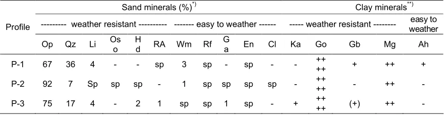
Table 4. Mineral compositions of sand and clay fraction of P-1, P-2, and P-3 profiles
Sand minerals (%)*) Clay minerals**)
--- weather resistant --- --- easy to weather --- --- weather resistant --- easy to weather Profile
Op Qz Li Os
o H
d RA Wm Rf
G
a En Cl Ka Go Gb Mg Ah
P-1 67 36 4 - - sp 3 sp - sp - - ++
++ + ++ +
P-2 92 7 Sp sp sp - 1 sp sp sp sp - ++
++ - ++
-P-3 75 17 4 - 2 1 sp sp 1 sp - + ++
++ (+) ++
-Remarks= *)Op = opaque, Qz = quartz, organic Oso (SiO2) = (organic silicon oxides), Hd = hidrargillite, Li = limonite,
Table 5. Texture, pH, organic-C, N, P and K of P-1, P-2, and P-3 profiles
Sand Silt Clay Organic
C
Proportional mean of P-1 12.7 58.1 29.2 5.6 4.8 0.85 0.07 5.92 2 2.12
P-2/
Proportional mean of P-2 5.4 42.2 52.4 5.97 5.02 0.87 0.07 6.70 2 2.18
P-3/
Proportional mean of P-3 6.9 30.6 62.5 6.5 6.3 0.85 0.07 2.32 3 2.11
Physical and Chemical Characteristics of the Soil
Physical and chemical characteristics of P-1, P-2, and P-3 soils were illustrated in Table 5 and 6. The substance of P-3 soil clay tends to be higher than P-1 and P-2 soils; this condition was supposed due to the difference of the bedrock so it influences the weathering intensity and the process of soil leaching in the upper layer of the soil and it tends to accumulate in the bottom layer of the soil before being leached out from soil solum. The acidity of P-3 soil was higher (pH 6.1-6.6) than P-1 (pH 4.4-5.9) and P-2 soil (pH 5.8-6.1). It was presumed due to the bases leaching in P-3 soil was lower. The diversity of the bedrocks had an effect on the weathering intensity and bases leaching (Buol et al., 1989).
C-organic and total N of P-1, P-2, and P-3 soils tend to be lowered along with the depth of the soil, in the upper layer, the C-organic substance was very high while the total N was moderate, then it decreased significant in the lowermost layer. This case was related to the increasing of organic
material accumulation in the soil surface that came from forest vegetation (before the oil palm plantation was opened).
The substance of total P (P2O5) and K (K2O) of P-1, P-2, and P-3 soil was considered to be very low, started from the upper till the bottom layer, except the total P in the upper layer of P-2 soil which was considered low (16.09 mg. (100 g)1). The substance of total P of P-1 and P-2 soil was higher than P-3 soil, while total K substance of P-3 soil was higher than P-1 and P-2 soil. The difference of soil total P and K substance was considered as a characteristic inheritance from the bedrock (Table 2).
presumed due to the intensity of soil weathering, most of P was leached along with silicate and bases that come out of the soil solum. The available P substance in the upper layer seems higher than the bottom layer of the P-1, P-2, and P-3 soil. It was because of the influence of soil materials that contain available P from upland due to erosion.
Exchangeable cations (Ca, Mg, K, and Na) of P-1 and P-2 soil in the whole layers were considered very low, except the substance of exchangeable Na in the fourth and fifth layer of P-1 soil that was considered low (0.12 and 0.15 cmolckg
-1
) and the substance of exchangeable Mg in the first layer of P-2 soil which was also considered low (0.62 cmolckg-1) (Table 6). The substance of exchangeable Ca and Mg in P-1 and P-2 soil was lower than in P-3 soil. It was because of the increasing of bases leaching that comes out from solum in the P-1 and P-2 soil. Due to the difference characteristics of bedrock, Velder and Meunier (2008) mentioned that the ratio of Al2O3/(Al2O3 + MgO) rocks could be used as an indicator of the intensity of rock weathering, the lower the ratio the higher the intensity of weathering. The ratio of Al2O3/(Al2O3 + MgO) harzburgite rock was 0.03 and serpentinite rock was 0.04, whereas olivine websterite rock was 0.31. It was shown that the weathering of serpentinite and harzburgite rock was 10 times faster than olivine websterite rock. The effect of high rainfall (Table 1) and porous soil condition, the elements which had high mobility (Ca, Mg, K, and Na) result of weathering, dissolved and leached out of soil solum. In addition, the higher substance of exchangeable Ca in P-3 soil was considered as a characteristic inheritance from the bedrock (Table 2).
Cation exchange capacity (CEC) of P-1, P-2, and P-3 soil tends to decrease along with the depth of the soil. Cation exchange capacity (CEC) on the top layer of soil was low and then decreased to very low in the lowest layer. This situation was expected because the influence of the organic matter substance decreased following the depth of the soil. Cation exchange capacity (CEC) of P-3 soil was higher than in the P-1 and P-2 soil. This was apparently associated with a lower intensity of weathering on P-3 soil so that there was still found mineral kaolinite in the formed clay minerals (Table 4) which had a higher CEC (3-15 cmolckg-1) than
goethite and magnetite (< 3 cmolckg-1) (Buol et al., 1989; Van Breemen and Buurman, 2003).
Exchangeable Al and Al saturation on P-1, P-2, and P-3 soil at all layers were very low. The exchangeable Al substance and Al saturation which were detected in upper layers (one and two) P-1 soil were associated with soil pH that was very acid (4.4) and acid (5.3) in that layer.
Base saturation (BS) of P-1 and P-2 soil tends to increase following the depth of the soil. The first up to fourth layer of P-1 soil had very low BS (5.41-16.14%), while the lowest layer (fifth) had moderate level of BS (58.99%). All layers in P-2 soil had the low BS (20.48-33.60%). The leaching of base cation that was high on the top layer of P-1 and P-2 soil results high accumulation of base cation in the lower soil layers. Base saturation (BS) of P-3 soil declines following the depth of soil from very high to low level (100.00-31.50%). This indicates that base leaching of P-3 soil takes place more intensively due to the swing ground water that moves quickly, whereas base leaching of P-1 and P-2 soil was more intensive due to percolation of water from above into the soil solum. Differences in soil water movement can be indicated by differences in soil texture, upper and lower layers. However, base leaching of P-3 soil does not as intensive as the leaching that occurs in P-1 and P-2 soil, so that BS of P-3 soil was higher than BS in P-1 and P-2 soil.
Soil Classification
Table 6. Exchangeable cation, cation exchange capacity, base saturation, exchangeable Al, and Al saturation of P-1, P-2, and P-2 profiles
Base cations exchangeable
Proportional mean of P-1 0.33 0.09 0.04 0.09 2.88 0.02 25.38 0.24
P-2/
Proportional mean of P-2 0.34 0.16 0.03 0.06 2.53 0.00 24.19 0.00
P-3/
Proportional mean of P-3 4.51 0.93 0.05 0.06 7.45 0.00 60.34 0.00
Remarks= CEC = cation exchange capacity, Ca = calcium, Mg = magnesium, K = potassium (K), Na = sodium, Exc. Al = exchangeable aluminium, BS = base saturation, ALS = aluminium saturation
P-2 soil formed from ultramafic rocks (serpentinite) in early age, characterized by a surface horizon with color values 3 and chroma 2 and had a base saturation < 50% so, it was classified as epipedon umbric. On the horizon below the surface (endopedon), there was significant clay increase and it had clay CEC < 16 cmolc.kg-1 and effective CEC < 12 cmolc.kg-1, it was classified at the level of family as Acrustoxic Kanhaplustults, clayey, ferruginous, and nonacid.
P-3 soil was formed from ultramafic rock (olivine websterite) in early age, characterized by a surface horizon with chroma 4, so it was classified as epipedon okrik. On the horizon below the surface (endopedon), there was a real clay increase and it had clay CEC < 16 cmolc.kg-1 and effective CEC < 12 cmolc.kg
-1
, it was more
appropriate to set it as candic horizon. Most horizons of BS were > 35% and had ustic soil moisture regime. Most of sectional controls had 2.5 YR in hue with value 2.5, clay substance was 54.9%; Fed 14.68%, and pH (H2O) 6.4. P-3 soil profile was classified at the level of family as Rhodic Kanhaplustalfs, clayey, ferruginous, and nonacid.
Land Suitability and Management for
Extensification of Oil Palm
quartz sand which indicate the low nutrient reserves in the soil, and it was also dominated by oxide clay minerals and iron hydroxide (goethite and magnetite), which indicates the low capacity of soil to keep nutrient reserves and it affects the efficiency of fertilization. Oil palm plantations which were cultivated on soil that developed from the three types of bedrock, if it does not properly managed, it will threaten its sustainability. The soil management should be directed to give effect on the characteristics of the soil, because usually soil had multiple problems, not only physical-chemical characteristic but also including mineralogical characteristic.
The form of soil management that can be applied such as planting cover crops legume group to improve N substance, soil organic matter, and as a form of soil conservation was limited to the minimum tillage planting hole only on the soil surface to minimize loss due to the nature of the loose soil. The use of organic materials to improve CEC soil and nutrient availability and the water holding capacity on the soil and fertilizer N, P, K, Ca, and Mg and other essential nutrients according to soil characteristics and the needs of oil palm so that soil productivity can be increased in an optimal and sustainable manner, and simultaneously increase the productivity of oil palm.
CONCLUSIONS
The soil from ultramafic rock in oil palm plantations in Langgikima was characterized by slightly acidic soil reaction to neutral (pH H2O 5.6-6.5), C-organic substance was very low (0.85-0.87%), total N was very low (0.07%), total P2O5 was very low (2.32-6.70 mg.(100 g)-1), total K2O was very low (2-3 mg.(100 g) -1), available P2O5 was very low (2.11-2.18 ppm), exchangeable Ca was very low to low (0.33-4.51 cmolckg-1), exchangeable Mg was very low to low (0.09-0.93 cmolckg-1), exchangeable K was very low (0.03-0.05 cmolckg-1), exchangeable Na was very low (0.06-0.09 cmolckg-1), the CEC was very low to low (2.53-7.45 cmolckg-1), exchangeable Al was very low (0-0.02 cmolckg
-1
), BS was low to moderate (24.19-60.34%), and clay minerals were dominated by iron oxides and hydroxide (goethite and magnetite).
The soil from harzburgite and serpentinite rocks was classified as Acrustoxic
Kanhaplustults, while soil from olivine websterite rock was classified as Rhodic Kanhaplustals.
The soil from ultramafic rock without fertilizer input was unsuitable (N2) for oil palm with the main limiting nutrient P availability was very low. Other soil characteristics that was quite problematic for the development of oil palm was the availability of nutrients N, K, Ca, and Mg and low CEC soil. The soil management in oil palm plantations to be applied was the addition of organic matter and fertilizer according to soil characteristics and the needs of oil palm so that soil productivity will be in an optimal and sustainable manner condition while productivity of oil palm will be increased.
REFERENCES
Alexander, E.B., R.G. Coleman, T. Keeler-Wolf and S. Harrison. 2007. Serpentine geoecology of Western North America geology, soils, and vegetation. Oxford University press. pp.512.
Bakosultanal. 1988. Peta land system dan land suitability skala 1 : 250.000, Lembar Sulawesi 2212, Seri RePProT. Badan Koordinasi Survei dan Pemetaan Nasional.
Buol, S.W., F.D. Hole and R.J. Cracken. 1989. Soil genesis and classification. The Iowa State University Press. Ames. pp.360. Certini, G. and R. Scalenghe. 2006. Soil : Basic
concepts and future challenger. Cam-bridge University Press. pp.330.
Cvetković, V., H. Downes, D. Prelević, M.
Jovanović and M. Lazarov. 2004.
Characteristics of the lithospheric mantle beneath East Serbia inferred from ultramafic xenoliths in palaeogene basanites. Contrib. Mineral. Petrol. 148: 335-357.
Djaenudin, D., Basuni, S. Hardjowigeno, H. Subagjo, M. Sukardi, Ismangun, D. Marsudi, L. Suharta, Hakim, Widagdo, J. Dai, V. Suwandi, S. Bachri dan E.R. Jordans. 1994. Kesesuaian lahan untuk tanaman pertanian dan tanaman kehutanan. Laporan Teknis No. 7, LREP II. CSAR, Bogor.
Dupuis, C., R. Hébert, V. Dubois-Côté, C. Guilmette, C.S. Wang, Y.L. Li and Z.J. Li. 2005. The yarlung zangbo suture zone ophiolitic melange (Southern Tibet) : New insights from geochemistry of ultramafic rocks. Journal of Asian Earth Sciences 25: 937-960.
FAO. 1990. Guidelines for soil profiles description. 3rd edition. FAO/UNESCO, Rome, Italy.
Faning, D.S. and M.C.B. Faning. 1989. Soil morphology, genesis, and classification. John Wiley and Sons, Inc. USA. pp.395. Hemon, M., B.H. Sunarminto, D. Shiddieq dan A.
Syukur. 2009. Potensi tanah berbahan induk harsburgit untuk pengembangan kelapa sawit di Langgikima, Konawe Utara, Sulawesi Tenggara. Laporan Penelitian Hibah Doktor. Lembaga Penelitian dan Pengabdian Kepada Masyarakat UGM. Yogyakarta. pp.156. Kartono, G. 1999. Kiat revitalisasi program
pengembangan usahatani berbasis padi memasuki era milenium ketiga Sulawesi Tenggara. Prosiding Seminar Regional. Balai Pengkajian Teknologi Pertanian Kendari. pp.474.
Lee, B.D., R.C. Graham, T.E. Laurent, C. Amrhein, and R.M Creasy. 2001. Spatial distribution of soil chemical condition in a serpentinitic wetland and surrounding landscape. Soil. Sci.Soc.Am.J.65: 1183-1196.
Lee, B.D., S. K. Sears, R. C. Graham, C. Amrhein, and H. Vali. 2003. Secondary mineral genesis from chlorite and serpentine in an ultramafic soil toposequence. Soil Sci. Soc. Am. J. 67: 1309–1317.
Licker, M.D. 2003. Dictionary of geology and mineralogy. McGraw-Hill Companies, Inc. pp.420.
Palandri, J.L and M. H. Reed, 2004. Geochemical models of metasomatism in ultramafic systems: serpentinization, rodingitization, and sea foor carbonate chimney precipitation. Geochimica et Cosmochi-mica Acta 68 (5) : 1115-1133.
Pusat Penelitian Tanah. 1982. TOR tipe-A survei kapabilitas Tanah. Dokumentasi No. 1/1982. Proyek P3MT. Badan Litbang Pertanian, Bogor. pp.50.
Pusat Penelitian Tanah. 1985. Survei tanah tinjau Provinsi Sulawesi Tenggara. Pusat Penelitian Tanah. Badan Penelitian dan Pengembangan Pertanian. Departemen Pertanian.
Schaetzl, R.J. and S. Anderson. 2005. Soils genesis and geomorphology. Cambridge University Press. pp.833.
Senda, R., T. Kachi, and T. Tanaka. 2006. Multiple records from osmium, neo-dymium, and strontium isotope systems of the Nikubuchi ultramafic complex in the Sambagawa Metamorphic Belt, Central Shikoku, Japan. Geochemical Journal 40:135-148.
Simandjuntak, S.O., Surono dan Sukido. 1994. Geologi lembar Kolaka, Sulawesi. Pusat Penelitian dan Pengembangan Geologi Direktorat jenderal Geologi dan Sumber-daya Mineral Departemen Pertambangan dan Energi RI. Bandung. pp.18.
Soil Survey Staff. 1993. Soil survey manual. Agric. Handbook No. 18. SCS-USDA, Washington DC.
Soil Survey Staff. 2010. Keys to soil taxonomy. United States Department of Agriculture, Natural Resources Conservation Service. pp.332.
Van Breemen, N. and P. Buurman. 2003. Soil formation. Second Edition. Kluwer Academic Publishers. New York, Boston, Dordrecht, London, Moscow. pp.419. Velder, B. and A. Meunier. 2008. The origin of
clay minerals in soils and weathered rocks. Agata Oelschäger. pp.406.
Wambeke, A.V. 1992. Soil of the tropics : properties and appraisal. McGraw-Hill, Inc. New York. pp.343.