Open Geospatial Consortium Inc.
Date: 2007-07-22
Reference number of this document: OGC 07-009r3
Version:1.3
Category: OpenGIS® Discussion Paper
Editor(s): Shayne Urbanowski
OGC Web Services Architectural Profile for the NSG
Copyright © 2007 Open Geospatial Consortium, Inc. All Rights Reserved. To obtain additional rights of use, visit http://www.opengeospatial.org/legal/.
Warning
This document is not an OGC® Standard. It is distributed for review and comment. It is subject to change without notice and may not be referred to as an OGC
Standard.
Recipients of this document are invited to submit, with their comments, notification of any relevant patent rights of which they are aware and to provide supporting documentation.
Document type: OpenGIS® Interoperability Program Report Document subtype: Candidate Best Practice
License Agreement
Permission is hereby granted by the Open Geospatial Consortium, ("Licensor"), free of charge and subject to the terms set forth below, to any person obtaining a copy of this Intellectual Property and any associated documentation, to deal in the Intellectual Property without restriction (except as set forth below), including without limitation the rights to implement, use, copy, modify, merge, publish, distribute, and/or sublicense copies of the Intellectual Property, and to permit persons to whom the Intellectual Property is furnished to do so, provided that all copyright notices on the intellectual property are retained intact and that each person to whom the Intellectual Property is furnished agrees to the terms of this Agreement.
If you modify the Intellectual Property, all copies of the modified Intellectual Property must include, in addition to the above copyright notice, a notice that the Intellectual Property includes modifications that have not been approved or adopted by LICENSOR.
THIS LICENSE IS A COPYRIGHT LICENSE ONLY, AND DOES NOT CONVEY ANY RIGHTS UNDER ANY PATENTS THAT MAY BE IN FORCE ANYWHERE IN THE WORLD.
THE INTELLECTUAL PROPERTY IS PROVIDED "AS IS", WITHOUT WARRANTY OF ANY KIND, EXPRESS OR IMPLIED, INCLUDING BUT NOT LIMITED TO THE WARRANTIES OF MERCHANTABILITY, FITNESS FOR A PARTICULAR PURPOSE, AND NONINFRINGEMENT OF THIRD PARTY RIGHTS. THE COPYRIGHT HOLDER OR HOLDERS INCLUDED IN THIS NOTICE DO NOT WARRANT THAT THE FUNCTIONS CONTAINED IN THE INTELLECTUAL PROPERTY WILL MEET YOUR REQUIREMENTS OR THAT THE OPERATION OF THE INTELLECTUAL PROPERTY WILL BE UNINTERRUPTED OR ERROR FREE. ANY USE OF THE INTELLECTUAL PROPERTY SHALL BE MADE ENTIRELY AT THE USER’S OWN RISK. IN NO EVENT SHALL THE COPYRIGHT HOLDER OR ANY CONTRIBUTOR OF INTELLECTUAL PROPERTY RIGHTS TO THE INTELLECTUAL PROPERTY BE LIABLE FOR ANY CLAIM, OR ANY DIRECT, SPECIAL, INDIRECT OR CONSEQUENTIAL DAMAGES, OR ANY DAMAGES WHATSOEVER RESULTING FROM ANY ALLEGED INFRINGEMENT OR ANY LOSS OF USE, DATA OR PROFITS, WHETHER IN AN ACTION OF CONTRACT, NEGLIGENCE OR UNDER ANY OTHER LEGAL THEORY, ARISING OUT OF OR IN CONNECTION WITH THE IMPLEMENTATION, USE, COMMERCIALIZATION OR PERFORMANCE OF THIS INTELLECTUAL PROPERTY.
This license is effective until terminated. You may terminate it at any time by destroying the Intellectual Property together with all copies in any form. The license will also terminate if you fail to comply with any term or condition of this Agreement. Except as provided in the following sentence, no such termination of this license shall require the termination of any third party end-user sublicense to the Intellectual Property which is in force as of the date of notice of such termination. In addition, should the Intellectual Property, or the operation of the Intellectual Property, infringe, or in LICENSOR’s sole opinion be likely to infringe, any patent, copyright, trademark or other right of a third party, you agree that LICENSOR, in its sole discretion, may terminate this license without any compensation or liability to you, your licensees or any other party. You agree upon termination of any kind to destroy or cause to be destroyed the Intellectual Property together with all copies in any form, whether held by you or by any third party.
Except as contained in this notice, the name of LICENSOR or of any other holder of a copyright in all or part of the Intellectual Property shall not be used in advertising or otherwise to promote the sale, use or other dealings in this Intellectual Property without prior written authorization of LICENSOR or such copyright holder. LICENSOR is and shall at all times be the sole entity that may authorize you or any third party to use certification marks, trademarks or other special designations to indicate compliance with any LICENSOR standards or specifications.
This Agreement is governed by the laws of the Commonwealth of Massachusetts. The application to this Agreement of the United Nations Convention on Contracts for the International Sale of Goods is hereby expressly excluded. In the event any provision of this Agreement shall be deemed unenforceable, void or invalid, such provision shall be modified so as to make it valid and enforceable, and as so modified the entire Agreement shall remain in full force and effect. No decision, action or inaction by LICENSOR shall be construed to be a waiver of any rights or remedies available to it.
Contents
Pagei. Preface... i
ii. Submitting organizations ... i
iii. Document contributor contact points... i
iv. Revision history ... i
v. Future work... ii
Foreword ... iv
Executive summary...v
1 Scope...1
2 Normative references ...1
2.1 NGA documents ...1
2.2 OGC Documents ...1
3 Terms and definitions ...2
4 Requirements and objectives of the NSG OWS ...4
5 Application OGC web services for the NSG ...5
5.1 Introduction ...5
5.2 Foundation concepts...6
5.2.1 Requirements on OGC technologies...6
5.2.2 Services, interfaces and operations ...7
5.2.3 OWS service framework...8
5.2.4 Publish-find-bind ...9
5.2.5 Multi-platform implementation approach...10
5.2.6 Multi-tiered architecture ...11
5.2.7 Service oriented architecture...16
5.2.8 Information ...18
5.3 OGC Web Services for NSG...19
5.3.1 OGC Web Map Service Overview ...19
5.3.2 OGC Styled Layer Descriptor Overview...20
5.3.3 OGC Web Feature Service Overview...21
5.3.4 OGC Web Coverage Service Overview ...21
5.3.5 Catalog ...22
5.3.5.1 Catalog components...22
5.3.5.2 Catalog as registry...24
5.3.5.3 Service publishing...25
5.3.6 Security and GeoDRM...28
5.4 Sensor Web Enablement (SWE) for NSG...30
5.4.1 Introduction...30
5.4.3 Observations and Measurements (O&M) [OGC 05-087r4]...36
5.4.4 SWE Common [OGC 05-086r2; OGC 05-087r2]...36
5.4.5 Transducer Model Language (TML) [OGC 06-010r5]...36
5.4.6 Sensor Observation Service (SOS) [OGC 06-009r2]...37
5.4.7 Sensor Alert Service (SAS) [OGC 06-028r3]...38
5.4.8 Sensor Planning Service (SPS) [OGC 05-089r3]...39
5.4.9 Web Notification Service (WNS) [OGC 06-095]...39
5.4.10 Sensor Web Registry...40
5.4.11 Applicability to NSG ...42
5.5 GeoProcessing Workflow (GPW) for the NSG ...43
5.5.1 GML application schemas ...44
5.5.2 Processing, exploitation and workflow services...47
5.5.3 Imagery handling ...51
5.5.4 GeoSemantics and GEOINT knowledge base ...54
5.5.4.1 Applicable OGC specifications and developments...55
5.5.4.2 Discussion of applying OGC specifications to meet NGA objectives ...55
5.6 Geo-Decision Support Services (GeoDSS) for NSG ...57
5.6.1 Integrated information environment and OWS portal architecture ...57
5.6.1.1 Applicable OGC specifications and developments...58
5.6.1.2 Discussion of applying OGC specifications to meet NGA objectives ...59
5.6.2 Integrated client ...60
5.6.2.1 Applicable OGC specifications and developments...61
5.6.2.2 Discussion of applying OGC specifications to meet NGA objectives ...61
6 Compliance ...66
6.1 Recommendations for NGA Web Services compliance test program ...67
6.2 Compliance testing overview ...69
6.3 Compliance testing tools overview ...73
6.3.1 Compliance test engine overview ...73
6.3.1.1 Compliance test engine technical description...73
6.3.1.2 Compliance test engine licensing...74
6.3.2 Compliance Test Script Notation Overview ...74
6.3.3 Reference implementations...74
6.4 Maturing OGC compliance test program for the benefit of the NSG ...76
6.5 Compliance testing documentation ...76
7 Development and governance...77
7.1 Standards adoption ...77
7.2 Prototyping and testbeds ...79
Figures
PageFigure 1 - Application of OWS to the NSG ... 5
Figure 2 - Service definition relationships... 7
Figure 3 - OWS Service Framework ... 8
Figure 4 - Publish/Find/Bind Pattern ... 9
Figure 5 – Services Interoperability Stack ... 11
Figure 6 - Service tiers in OWS Architecture ... 13
Figure 7 - Catalog Reference Model Architecture ... 23
Figure 8 - Catalog ebRIM Model ... 26
Figure 9 - Catalog Class Model ... 27
Figure 10 - Sensor Web Concept... 31
Figure 11 - SWE Information Models ... 32
Figure 12 - OGC Sensor Web Enablement framework ... 33
Figure 13 - Notional Standard Driven Architecture ... 42
Figure 14 - UML to GML Schema Conversion ... 46
Figure 15 - Data Reduction... 49
Figure 16 - TQAS Workflow ... 50
Figure 17 – Geo-Processing Workflow ... 52
Figure 18- WCS/JPIP Architecture ... 54
Figure 19 - Four roles and their relationships comprising a basic SSOA (Semantic Service-oriented Architecture). ... 56
Figure 20 - Schematic representation of multiple ontologies used to perform a geospatial semantic (cross-domain) query. ... 57
Figure 21 - OWS Portal Reference Architecture... 60
Figure 22 - Compliance Testing Process ... 70
Figure 23 - Draft SDI 1.0 Suite... 72
Figure 24 - Compliance Test Engine... 74
i. Preface
Suggested additions, changes, and comments on this draft report are welcome and encouraged. Such suggestions may be submitted by email message or by making suggested changes in an edited copy of this document.
The changes made in this document version, relative to the previous version, are tracked by Microsoft Word, and can be viewed if desired. If you choose to submit suggested changes by editing this document, please first accept all the current changes, and then make your suggested changes with change tracking on.
ii. Submitting
organizations
The following organizations submitted this document to the Open Geospatial Consortium Inc.
BAE Systems Lockheed Martin Northrop Grumman Rosettex
iii.
Document contributor contact points
All questions regarding this document should be directed to the editor or the contributors:
Name Organization
Ron Fresne Rosettex
Chuck Heazel Lockheed Martin Lew Leinenweber BAE Systems Jen Marcus Northrop Grumman George Percivall OGC
Raj Singh OGC
Shayne Urbanowski Lockheed Martin
iv. Revision
history
Date Release Editor Primary clauses modified
Description
2006 2 November
2006
0.2 S. Urbanowski All Revisions and global modifications 22 December
2006
0.9 S. Urbanowski All Fold in contributions and SWE material
January 2, 2007
0.9.3 Heazel, Urbanowski
All Included additional material
January 31, 2007
0.9.4 Urbanowski All Captured and incorporated comments
March 22, 2007
1.0 Urbanowski All Incorporated final edits
April 27, 2007
1.1 D. Wesloh All Incorporated NGA Public Release comments
June 15, 2007
1.1 Urbanowski All Incorporated comments from initial review
July 22, 2007 1.3 Urbanowski Terms & Defs Added term definitions
v. Future
work
A description of Web Map Context is necessary within the Section 4.3, OGC Web Services for the NSG. Ideally this material would be placed in to a new sub-section, 4.3.3.
It would be useful to include a discussion of how DoD Information Technology Standards and Profile Registry are represented within this profile. This work would provide use cases and DoDAF views and should fit into Section 4.1.1.
The initial sponsors of this document have requested that this work include a mapping of NSG Data Sources, or NGA Products, to OWS services and profiles. This information should be included in Section 4.1.2.
This document was originally intended to provide a section describing the Creating Features from Observations, Section 4.5.4. Resource limitations prevented this work from being done. The relevant NGA excerpt and applicable OGC specifications are shown below. This work should be provided as resource become available.
management and delivery of the right information, in the right format, at the right time and classification.
Applicable OGC Specifications and developments
• Observations and Measurement specification (05-087)
• Schema Maintenance and Tailoring discussion paper (05-117)
• GML Spec (v3.1.1),
• Clause 8, GML schemas – feature model
• Clause 23. Rules for Application Schemes
• ISO 19110 General Feature Model
• Schema Tailoring and Maintenance - DIPR
Foreword
The National Center for Geospatial Intelligence Standards (NCGIS) of the National Geospatial-Intelligence Agency (NGA) is participating in the Open Geospatial Consortium (OGC) Interoperability Program Open Web Services activity, Phase 4 (OWS-4). NGA/NCGIS is undertaking this activity in support of one of the
modernization goals for the National System for Geospatial-Intelligence (NSG). This goal is to increase NGA’s capabilities to leverage existing market driven Standards– based Commercial Off-The-Shelf (SCOTS) solutions for fulfilling analyst’s needs in undertaking their missions. Part of NCGIS’ mission is to ensure that commercial industry addresses NGA interoperable technology requirements.
The NCGIS, through efforts such as the OGC’s Interoperability Program, works to ensure standards and standards-based commercial software developments are accelerated. The goal is for these standards and software elements, addressing NSG requirements, to be ready for implementation when the GeoScout contractor begins that phase of
Executive summary
The purpose of this document is to generally describe how the various OGC
specifications may be used to address the needs of a large enterprise system. It highlights the key elements of the OWS-4effort as they relate to web service architecture
implementation at NGA and in the NSG. The goal is that this document will enable organization that interface with the NSG to understand how to produce and consume data and services in an interoperable environment.
The document includes description of all applicable OGC specification, the relationship of theses specifications to NSG concepts, the relationship of these specifications to each other and architectural concepts related to the application of these specifications.
Foundational concepts such as net-centric and service oriented architecture are presented. This is followed by a discussion of service models, information models, OWS-4 results and other OGC topics which are applicable to the NSG.
The technologies discussed as part of this profile include:
• OGC Service Framework
• OGC Web Services (WMS, WFS, WCS)
• Catalog (CS-W)
• Geospatial Digital Rights Management (GeoDRM)
• Sensor Web Enablement (SPS, SOS, SAS, WNS, SensorML, TransducerML)
• Geo-Processing Workflow
• Geo-Decision Support Services (GeoDSS)
• Compliance Testing
It is expected that the vendor community’s support for these specifications will continue to increase, and this document will act as a guide for the NGS, NSG connected
organizations and the broader federal geospatial community. This document is intended to complement other documents such as the Spatial Data Infrastructure 1.0 (SDI) in that it provides a comprehensive description of OGC specifications, a context of how they apply to the NSG domain and a description of how the specifications can be assembled to meet the needs of an enterprise.
OWS Implementation Profile includes the following elements: Executive Overview
• • •
Technologies recommended.
1 Scope
OGC specifications capture general purpose capabilities independent of any particular operational environment. For many organizations, however, these general capabilities are not sufficient. Additional documentation is required to provide developers the guidance they need to apply OGC specifications and design patterns within their specific operational context. OGC Implementation Profiles provide that guidance.
This OGC Document defines an Implementation Profile of the OGC Web Services for use by the National Geospatial-Intelligence Agency (NGA) in the National System for Geospatial Intelligence (NSG).
This document is developed as part of the OGC Web Services, Phase 4 (OWS-4) Interoperability Initiative.
This document will be offered for consideration as a Best Practice Document by the OGC Specification Program.
2 Normative references
The following normative documents contain provisions that, through reference in this text, constitute provisions of this document. For dated references, subsequent
amendments to, or revisions of, any of these publications do not apply. For undated references, the latest edition of the normative document referred to applies.
2.1 NGA documents
NSG Statement of Strategic Intent - March 2007
Geospatial Intelligence Standards; Enabling a Common Vision - November 2006 Joint Vision 2020 – June 2000
2.2 OGC Documents
OGC 04-021, Catalogue Service Implementation Specification
OGC 01-009, Coordinate Transformation Service Implementation Specification
OGC 04-095, Filter Encoding Implementation Specification
OGC 03-105, Geography Markup Language (GML) Encoding Specification
OGC 05-047, GML in JPEG 2000 for Geographic Imagery Encoding Specification
OGC 02-070, Styled Layer Descriptor (SLD) Implementation Specification
OGC 06-083, Web Coverage Service Implementation Specification
OGC 04-094, Web Feature Service Implementation Specification
OGC 05-005, Web Map Context Implementation Specification
OGC 06-042, Web Map Service Implementation Specification
OGC 06-121r3, OpenGIS® Web Services Common Specification
OGC 06-103, 06-104, Simple Feature Access Implementation Specification
OGC 06-086, SDI 1.0
3 Terms and definitions
The following terms and definitions are used in this document.
Application schema – set of conceptual schema for data required by one or more applications.
Business Process- an interaction between participants and the execution of activities according to a defined set of rules in order to achieve a common goal [Business Process Modeling Language Proposed Draft Specification]
Client - A software component that can invoke an operation from a server Conceptual schemas (also called base schemas)
Coordinate reference system – coordinate system that has a reference to the Earth. Coverage is a feature that associates positions within a bounded space (its
spatiotemporal domain) to feature attribute values (its range)
DAFIF - Digital Aeronautical Flight Information File - database of aeronautical data, including information on airports, airways, airspaces, navigation data developed for the benefit of military aeronautical operations by the NGA.
DCP – Distributed Computing Platform – the collection of protocols, services and conventions that services use to invoke remote operations. Examples include CORBA, DCOM, WEB (SOAP) and Web (HTTP get/post)
DISR - Department of Defense (DoD) Information Technology Standards Registry - Online repository for a minimal set of primarily commercial IT standards formerly captured in the Joint Technical Architecture (JTA), Version 6.0. These standards facilitate integration of new systems into the Global Information Grid (GIG) are used as the "building codes" for all systems being procured in the Department of Defense. DoDAF - Department of Defense's Architecture Framework - is the concepts
presented in the Command, Control, Communications, Computers, Intelligence, Surveillance and Reconnaissance (C4ISR) Architecture Framework. The primary purpose is to provide guidance in describing both warfighting operations and business operations and processes. It provides guidance, rules and product descriptions of how to describe an architecture using four views. Each view is made up of various
General feature model – metamodel of feature types
Geographic feature – feature associated with a location relative to the Earth.
GEOINT Discipline– encompasses all activities involved in the planning, collection, processing, analysis, exploitation and dissemination of spatial information in order to gain intelligence about national security or operational environment, visually depict this knowledge and fuse the acquired knowledge with other information through analysis and visualization processes. [NSG Statement of Strategic Intent]
GIG - Global Information Grid - provides authorized users with a seamless, secure, and globally interconnected information environment, meeting real-time and near real-time needs of both the warfighter and the business user.
GML – Geography Markup Language
Interface – named set of operations that characterize the behavior of an entity [6] Interoperability - capability to communicate, execute programs, or transfer data among various functional units in a manner that requires the user to have little or no knowledge of the unique characteristics of those units [ISO 2382-1]
Map projection – coordinate conversion from a geodetic coordinate system to a planar surface.
Metadata – Information that describes, or supplements, the central data. It provides information about the identification, the extent, the quality, the spatial and temporal schema, spatial reference, and distribution of digital geographic data.
National System for Geospatial Intelligence (NSG) - Combination of technology, policies, capabilities, doctrine, activities, people, data and communications necessary to produce geospatial intelligence (GEOINT) in an integrated multi-intelligence, multi-domain environment. [NSG Statement of Strategic Intent]
OGC – Open Geospatial Consortium
Operation – Specification of an interaction that can be requested from an object to effect behavior. [ISO 19119]
Property - A facet or attribute or an object referenced by a name ORM – OGC Reference Model
Service request - A request by a client of an operation from a service.
Service - A collection of operations, accessible through an interface that allows a user to evoke a behavior of value to the user. [ISO – 19119]
Service chain - sequence of services where, for each adjacent pair of services, occurrence of the first action is necessary for the occurrence of the second action [ISO 19119]
Service Framework - a partially complete (sub-)system that is intended to be
instantiated. It defines the architecture for a family of (sub-)systems and provides the basic building blocks to create them.
Spatial Reference System – As defined in the OpenGIS Abstract Specification Topic 2 and ISO 19111.
Viewpoint – form of abstraction achieved using a selected set of architectural concepts and structuring rules, in order to focus on particular concerns within a system. [ISO-10746-2]
4 Requirements and objectives of the NSG OWS
This section documents Requirements and Objectives for achieving NSG objectives based on OGC Web Services. Excerpts from several documents provided to OGC as Government Furnished Information (GFI) are quoted to guide development of the OGC Web Services Architecture Implementation Profile for the NSG.
The NSG Vision: “An integrated, collaborative community of GEOINT professionals embedded with our operational and national partners to meet their warfighting and intelligence needs.” [Excerpt from NSG Statement of Strategic Intent]
Ensure the integrated and optimized use of airborne, commercial, advanced geospatial intelligence, foreign and national satellite collection. Accelerate the standardization of sensor data, metadata, compression formats and file identifiers. Develop strategies and methods for addressing the exponential increase in data and information to ensure all relevant data is analyzed. [Excerpt from NSG Statement of Strategic Intent]
Implement a GEOINT Unified Operations Strategy through a formal network to facilitate integrated GEOINT operations. [Excerpt from NSG Statement of Strategic Intent]
Standardization efforts within the NSG are bringing together diverse national and
international community members to implement geospatial data standards that, through a Service-Oriented_Architecture (SOA), enhance interoperability across these
communities. [Excerpt from Geospatial Intelligence Standards; Enabling a Common Vision]
Through strong collaboration and our understanding of the mission, we will focus outwardly and build enduring partnerships. Capitalize on the value-added collection and exploitation from GEOINT users in the field. [Excerpt from NSG Statement of Strategic Intent]
Achieve front-end/back-end alignment to address collection platforms, building a foundation knowledge base and comprehensive access to NSG products and services. Articulate NSG requirements for sensor platform development, data dissemination, data storage, and data exploitation to achieve an optimally balanced investment strategy. [Excerpt from NSG Statement of Strategic Intent]
Interoperability in a net centric environment is dependent on the development and industry-wide acceptance and implementation of non-proprietary standards and specifications for web-based applications. [Excerpt from Geospatial Intelligence Standards; Enabling a Common Vision]
Interoperability is a mandate for joint force 2020 – especially in terms of
our mission success. These standards need to ensure access to timely, relevant, and accurate GEOINT data, services, and products regardless of source, exploitation process, or production element. [Excerpt from Geospatial Intelligence Standards; Enabling a Common Vision]
Reduce technology costs by increasing usage of standards-based commercial-off-the-shelf software (SCOTS), reduce custom solutions and associated maintenance costs. [Excerpt from Geospatial Intelligence Standards; Enabling a Common Vision] Expanding roles for multinational and interagency partners will require collaborative planning capabilities, technological compatibility/interoperability, and mechanisms for efficient information sharing. [Excerpt from Vision 2020]
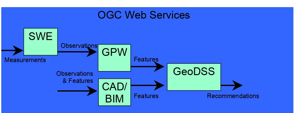
5 Application OGC web services for the NSG
5.1 Introduction
OGC Web Services
SWE
Measurements
Observations
Observations & Features
GPW
Features
GeoDSS
CAD/
BIM
Features RecommendationsFigure 1 - Application of OWS to the NSG
Figure 1 shows some of the major OWS-4 work areas and how they relate to each other in an operational context. These work areas are:
•
•
Sensor Web Enablement (SWE) - addresses the creation of sensor networks including services for tasking, processing and notification. The objective of SWE is to make measurements from any sensor readily available for exploitation.
Geo-Processing Workflow (GPW) - addresses the interoperable processing of
•
•
Geospatial Decision Support Services (GeoDSS) - addresses the tools and applications used to implement the decision support process.
Computer Aided Design (CAD) and Building Information Model (BIM) - The data sets used to design, build and maintain a building have strong similarities to
geospatial data. An on-going CAD/GIS effort is working to integrate these two communities into an interoperable information framework. This will greatly expand the information available to the decision support analyst.
Subsequent sections of this document will explore these efforts and show their application to NSG objectives.
5.2 Foundation concepts
5.2.1 Requirements on OGC technologies
This section focuses on identifying key requirements on OGC technologies. Before listing these requirements, it is important to note that OGC technologies are not limited to the specifications formalized by the consortium; they also include working
implementations of such specifications. As such, in order to support the geospatial information value chain, OGC technologies must:
- Be agile so as to be able to adapt to changing business rules and operational requirements;
- Support the easy and seamless introduction of new technologies and the evolution of existing ones;
- Provide for robustness and consistent error handling and recovery to support mission-critical systems development;
- Accommodate authentication, security and privacy features and support asset protection;
- Be platform independent (e.g., DCP, hardware, OS, programming language, encodings, etc);
- Support implementations of N-tiered, component architectures;
- Support standard interfaces and metadata while accommodating the use of other complementary standards and specifications in environments where OpenGIS specifications are implemented;
- Support interoperability by specifying interface definitions, service descriptions and protocols for software collaboration and negotiation;
organizations (W3C, IETF, OMG, AMIC and others), generally offering expertise related to spatial issues and receiving expertise necessary to ensure that OGC's standards
framework is consistent with other IT standards frameworks.
- Accommodate independently developed implementations of a service and many independently provided instantiations of different types of services;
- Accommodate a wide range of data policies (e.g., data access and data use policies); - Be vendor and data neutral;
- Be data content format independent.
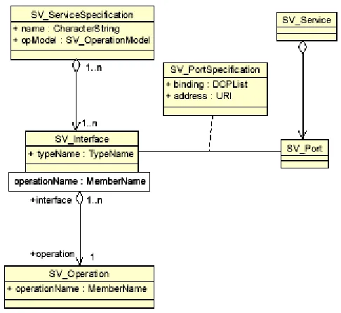
5.2.2 Services, interfaces and operations
Key definitions for the Service Framework are:
- A Service as a distinct part of the functionality that is provided by an entity through interfaces,
- An Interface as a named set of operations that characterize the behavior of an entity, - An Operation as a specification of a transformation or query that an object may be called to execute. Each operation has a name and a list of parameters.
Figure 2 - Service definition relationships
A service may be expressed at various levels of granularity. A coarse-grained
accomplished by expanding one or more operations from a high level collaboration into distinct lower level services, one for each operation.
An instance of a service may be associated with a specific instance of a dataset, or it may be a service that can be used to operate on multiple, unspecified datasets. The first case is referred to as a tightly coupled data and service. The second case is referred to as loosely coupled service. Service operations can be associated with data classes (data type) or with instances (data set).
5.2.3 OWS service framework
The OWS Service Framework (OSF) identifies services, interfaces and exchange
protocols that can be utilized by any application. OpenGIS Services are implementations of services that conform to OpenGIS Implementation Specifications. Compliant
applications, called OpenGIS Applications, can then "plug into" the framework to join the operational environment.
By building applications to common interfaces, each application can be built without a-priori or run-time dependencies on other applications or services. Applications and services can be added, modified, or replaced without impacting other applications. In addition, operational workflows can be changed on-the-fly, allowing rapid response to time-critical situations. This loosely coupled, standards-based approach to development results in very agile systems—systems that can be flexibly adapted to changing
requirements and technologies
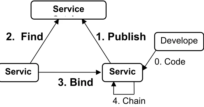
5.2.4 Publish-find-bind
The OWS Service Framework is based on the publish/find/bind pattern shown in Figure 4. This pattern enables dynamic binding between service providers and requestors. Dynamic binding is an essential capability for distributed environments where operational needs, sites and applications are frequently changing.
2. Find
0. Code
1. Publish
3. Bind
C t l
Servic
Service
Servic
Develope
4. Chain
Figure 4 - Publish/Find/Bind Pattern
In Figure 4, there are three essential roles:
- Service provider: publishes services to a broker (registry) and delivers services to service requestors.
- Service requestor: performs service discovery operations on the service broker to find the service providers it needs and then accesses service providers for provision of the desired service.
- Service broker: helps service providers and service requestors to find each other by acting as a registry or clearinghouse of services.
As shown, there are three essential kinds of operations performed by services: - Publish: used to advertise data and services to a broker (such as registry, catalog or clearinghouse). A service provider contacts the service broker to publish (or unpublish) a service. A service provider typically publishes to the broker metadata describing its capabilities and network address.
- Bind: used when a service requestor and a service provider negotiate, as appropriate, so the requestor can access and invoke services of the provider. A service requestor typically uses service metadata provided by the broker to bind to a service provider. The service requestor can either use a proxy generator to generate the code that can bind to the service, or can use the service description to manually implement the binding before accessing that service. Figure 4 also shows that services can be chained with various degrees of transparency to achieve larger tasks required by a service
5.2.5 Multi-platform implementation approach
Ensure discovery, access, dissemination and management of all GEOINT data stores through a web-enabled service-oriented-architecture. [Excerpt from NSG Statement of Strategic Intent]
A Distributed Computing Platform (DCP) is the collection of protocols, services and conventions that applications use to invoke remote operations. There have been many popular DCPs over the years including CORBA, DCOM and DCE. Each of these platforms have their strengths and weaknesses. Web Services must also be viewed as a DCP. Like the others, the web services model has its’ strengths and weaknesses. There are applications for which web services are not appropriate. We can also expect that, with the development of new distributed computing technologies, web services will eventually become obsolete. Developers of interoperability standards must be prepared to deal with this continuous change in DCP implementing technology as well as the simultaneous fielding of multiple DCP implementations. The OGC addresses this problem by separating the business logic (conceptual specification) from the DCP specific implementation guidance (implementation specification).
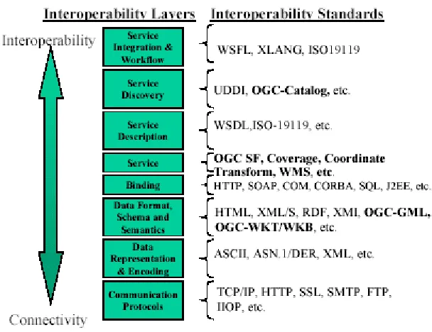
Figure 5 – Services Interoperability Stack HTTP as Distributed Computing Platform
OGC has defined a suite of Web Service interfaces that have explicit bindings for HTTP. Specifically, there are two HTTP bindings for invoking operations of a service (i.e., Sending a message): GET and POST. Thus the Online Resource for each operation supported by a service instance is an HTTP Uniform Resource Locator (URL). Only the parameters comprising the service request itself are mandated by OGC Web Service Specifications for HTTP.
SOAP as an OGC Web Services Enabler
SOAP is an XML-based remote procedure call protocol that allows messages to be exchanged between different services. SOAP is used for the bind operation described above. Development of SOAP bindings for the existing OGC Web Service specifications is underway.
5.2.6 Multi-tiered architecture
Multi-tier architecture also known as n-tier architecture or sometimes n-tier computing refers to the number of logical levels or layers that the various components of an application occupy. Typical tiers include components for user presentation (GUI), presentation logic, business or application logic, data access, and data storage. Tiers can be physically located anywhere, including on a single computing platform (even in a single monolithic application). In single-platform applications the interaction between tiers is tightly coupled by the language the application is written in and/or the architecture of the host operating system. In net-centric, enterprise, Internet-based and Web-Service applications logical tiers are distributed physically across networks. In such distributed n-tier architectures interoperability between tiers is much more loosely coupled.
flow control are examples of transactions that can be more difficult as each tier may run on different operating systems, be written in multiple software languages, and
communicate using several protocols. Technology-specific enterprise frameworks have been developed to address some of these challenges. Examples of these enterprise frameworks include J2EE or .NET, which address interoperability challenges of
distributed computing by constraining options more narrowly around specific enterprise technologies. For example, J2EE is built around java-based technologies and .NET around Microsoft Windows.
The goal of OGC-based architectures is to provide interoperability beyond the technology viewpoint. This goal is accomplished by defining higher-level interface specifications that are independent of individual technical implementations. This approach helps meet the NSG’s common vision for Geospatial Intelligence (see: Geospatial Intelligence Standards: Enabling a Common Vision
http://www.nga.mil/NGASiteContent/StaticFiles/OCR/ncgis-eb.pdf). Distributed n-tier architectures have to address interoperability across tiers independent of technology if goals such as technology risk reduction, improved choice and competition in the marketplace, reduced technology costs, and the ability to rapidly insert new technology are to be achieved, (Ibid p.13).
In an earlier OpenGIS® best practices paper (OpenGIS® web services architecture description OGC 05-042r2), OGC has set out a web services architecture around OGC interfaces. This n-tier architecture shown in figure TBD defines three services types (or components) loosely arranged in four tiers, from Clients to Application Services to Processing Services to Information Management Services (but un-needed tiers can be bypassed.)
This Service Oriented Architecture is based on the fundamental roles of service provider and service consumer within a distributed computing system. This pattern emphasizes that desired computing can be realized by combining multiple services, for each of which only the service types (e.g., interfaces and abilities) and server data holdings (e.g.
Figure 6 - Service tiers in OWS Architecture
As shown n the OWS Architecture service components are organized into multiple tiers. 1. All components provide services, to clients and/or other components, and each
component is usually called a service (with multiple implementations) or a server (each implementation).
2. Services (or components) are loosely arranged in four tiers, from Clients to Application Services to Processing Services to Information Management Services, but un-needed tiers can be bypassed.
3. Services can use other services within the same tier, and this is common in the Processing Services tier.
4. Each tier of services has a general purpose, which is independent of geographic data and services.
5. Each tier of services includes multiple specific types of services, many of which are tailored to geographic data and services.
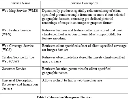
Information Management Services Tier
The Information Management Services tier contains services designed to store and provide access to data, with each server normally handling multiple separate datasets. In addition, metadata describing multiple datasets can be stored and searched. Access is usually to retrieve a client-specified subset of a stored dataset, or to retrieve selected metadata for all datasets whose metadata meets client-specified query constraints. (OGC 05-042r2 p 14.)
Service Name Service Description
Web Map Service (WMS) Dynamically produces spatially referenced map of client-specified ground rectangle from one or more client-selected geographic datasets, returning pre-defined pictorial
renderings of maps in an image or graphics format Web Feature Service
(WFS)
Retrieves features and feature collections stored that meet client-specified selection criteria. Must support GML for feature encoding
Web Coverage Service (WCS)
Retrieves client-specified subset of client-specified coverage (or image) data set.
Catalog Service for the Web (CSW)
Retrieves object metadata stored that meets client-specified query criteria
Gazetteer Service Retrieves location geometries for client-specified geographic names
Universal Description, Discovery and Integration Service
Allows a client to find a web-based service
Table 1 - Information Management Services Processing Services Tier
The Processing Services tier contains services designed to process data, sometimes both feature and image (coverage) data. The services in the Processing Services tier are used by clients and by services in the Application Services tier. These services can use other services in the Processing Services and Information Management Services tiers. (OGC 05-042r2 p 15-16.) There are many examples of Processing Services and exhaustive list is impossible to construct as news processing services are always being proposed and developed. Below are several examples.
SLD enabled Web Map Service (WMS): Dynamically produces spatially referenced maps from geographic feature and/or coverage data, returning client-specified pictorial renderings of maps in an image format (not actual feature data or coverage data)
Web 3D Service (W3DS): Dynamically produces client-specified perspective views from geographic feature data, returning perspectives of feature data in a graphical format
Web Coordinate Transformation Service (WCTS): Transforms the coordinates of feature or coverage data from one coordinate reference system (CRS) to another, including “transformations”, “conversions”, rectification, and orthorectification Web Image Classification Service (WICS): Performs classification of digital images, using client-selected supervised or unsupervised image classification method
Feature Portrayal Service (FPS): Dynamically produces client-specified pictorial renderings in an image or graphics format of features and feature collections usually dynamically retrieved from a Web Feature Server (WFS)
Coverage Portrayal Service (CPS): Dynamically produces client-specified pictorial renderings in an image or graphics format of a coverage subset dynamically retrieved from a Web Coverage Service (WCS)
Topology Quality Assessment Service (TQAS): Execute logical domain constraints (semantic structure) consistency rules on features within a Web Services
environment.
Web Processing Service (WPS): Provide services dynamic access across a network to pre-programmed calculations and/or computation models that operate on spatially referenced data. The calculation can be extremely simple or highly complex, with any number of data inputs and output Process P1 produces results R1-RN from input I1-Ii
Application Services Tier
The Application Services tier contains services designed to support Clients, especially thin client software such as web browsers. That is, these Application Services are designed for use by clients instead of each client directly performing these often-needed support functions. In “thicker” clients this tier is often contained within the application logic of the client and as a consequence concrete implementation specifications for most of these services have not yet been developed. The following, however are examples of a few of the types of services found in the application services tier.
• Web portal services: Services that allow a user to interact with multiple application services for different data types and purposes
• WMS application services: Services that allow a user to interact with a (WMS) to find, style, and get data of interest
• Gazetteer application services: Services that allow a user to interact with a Gazetteer service
• Geographic data extraction services: Services that allow a user to extract and edit feature data, interacting with images and feature data
• Geographic data management services: Services that allow a user to manage geospatial data input and retirement, interacting with Information Management Services
• Access control services: Services that control access to other servers, for privacy, intellectual property, and other reasons
Tying it all together: Service Interfaces
Components within and across tiers rely on service interface specifications to define the operations that characterize the behavior of the entity. OGC web service interfaces use open standards and are relatively simple. In addition to being well-specified,
interoperable, and tested; the OGC-specified service interfaces are coarse-grained, providing only a few static operations per service. Several of these key service interfaces are included in the SDI 1.0 and are providing the foundation for NGA’s interoperable net-centric environment.
5.2.7 Service oriented architecture
Build a responsive GEOINT IT infrastructure to promote transparency and information sharing in a multi-intelligence environment across the DoD and IC. Ensure discovery, access, dissemination and management of all GEOINT data stores through a web-enabled service-oriented-architecture. [Excerpt from NSG Statement of Strategic Intent]
Complementing the Real Time Infrastructure and executing on it will be an extensive suite of mission and corporate applications designed as interoperable elements of a Service Oriented Architecture (SOA). The SOA will draw upon services provided by other entities, entities both externally and within the NSG. It will also make available its defined services to those entities for incorporation in their respective mission activities. Developing an SOA as a subset to the overall enterprise architecture will serve as a key enabler for identifying and maximizing horizontal fusion opportunities and leverage economies of scale. It will allow for leveraging common line-of-business opportunities as well as creating efficiencies for overall IT services. To fully leverage the benefits of SOA, business managers must make it an integral part of IT management processes, including application development outsourcing, investment management and enterprise architecture. Web services, a key element of an SOA, promises to improve reuse of code and to enable easier composition of new application functions by drawing on established subsets of functionality available as services. By wrapping established
Web services are self-describing, self-contained, modular units of software that define business functionality. Web services are consumable software services that typically include some combination of business logic and data. Web services can be aggregated to establish a larger workflow or business transaction. Inherently, the architectural
components of web services support messaging, service descriptions, registries, and loosely coupled interoperability.
It’s important to understand that SOA is a design pattern, not a specific technology. The particular technologies used and governance rules vary depending on the operating environment.
For example, the common practice of web-enabling the interfaces of existing
applications can work well for a relatively small, centrally managed enterprise. For an environment like the GIG, however, such an approach will result in an
overwhelming number of similar but incompatible services. Service consumers will have to code their clients for a limited selection of services, thus perpetuating the stovepipe model. This problem is further aggravated by the configuration management and security policies that govern DoD and IC systems. Once accredited, these systems cannot be modified. Therefore, DoD and IC systems can only use services that were known to the developer at the time the software was developed.
The OGC and ISO TC-211 have addressed this problem by creating a taxonomy of service interface types and rules for specializing those types as shown below. This approach provides developers with a finite number of well defined and tested interfaces to support. Service providers, in turn, are expected to implement their business logic behind one or more of those interfaces. As a result, the large scale many-to-many interactions that SOA promises become possible.
ISO 19119 Geographic services taxonomy:
• Geographic human interaction services
• Geographic model/information management services
• Geographic workflow/task management services
• Geographic processing services
o Geographic processing services – spatial o Geographic processing services – thematic o Geographic processing services – temporal o Geographic processing services – metadata
• Geographic communication services
• Geographic system management services
Implementing technology, or Distributed Computing Platform (DCP), is also dependent on the operating environment. For example, GeoConnections Canada is a SOA
operation name and parameters. This approach has proven to be easy to implement and is easily adaptable to changes in the supporting technology.
For NGA and the GIG environment, a more complex approach is needed. While services in this environment are still loosely coupled, there are additional security, performance and reliability requirements. These requirements lead us to a SOAP based DCP. Effective July 2006, all future revisions of existing and new OWS interface specifications must include an optional SOAP messaging binding and the binding must be expressed in WSDL. While it is true that some OGC specifications do not currently have approved SOAP bindings, the separation of binding from service definition makes the development of SOAP bindings relatively straight forward. In fact, implementations of the draft OGC SOAP interfaces are available from some SCOTS vendors.
Applicable OGC Specifications:
• OGC Topic 12 which is also ISO 19119, Geographic Information Services.
(02-112)
5.2.8 Information
Technology comes and goes but data lives forever.
The most valuable part of any IT enterprise is the data that has been accumulated. This value, however, depends on that data being sufficient, available, comprehensible and of acceptable quality. In other words:
• The data structures must be sufficiently rich to capture all of the information that users might need,
• There must be an easy way to find and access the data,
• Once accessed, the users’ tools have to be able to process (understand) the data.
• Data being of acceptable quality may include a certain positional accuracy, a certain currency, a certain fitness for use.
Data sufficiency poses a problem, how do you know what information to include if you don’t know who or how that data will be used? The OGC and ISO address this issue by approaching data definition from the producer perspective as opposed to the consumer. The question becomes not “what information do I need” but “what information can I provide”. Data models are defined in terms of our ability to collect data regardless of how it my ultimately be used.
•
•
•
•
Vector Product Format Level 0, 1 and 2. Local Mission Specific Data
NSG Feature Catalog v 1.8 DAFIF 9
Another consequence of the producer focus is that data models should not make any assumptions about how they will be used. In particular, data content is separated from the representation of that content. This runs counter to traditional geospatial products such as VPF. However, it is in line with current DoD data policy as documented in the DoD Data Strategy. It is also in line with the planned update of Common Warfighting Symbology (Mil-Std 2525).
5.3 OGC Web Services for NSG
5.3.1 OGC Web Map Service Overview
A Web Map Service (WMS) produces maps of spatially referenced data dynamically from geographic information. This International Standard defines a "map" to be a portrayal of geographic information as a digital image file suitable for display on a computer screen. A map is not the data itself. WMS-produced maps are generally
rendered in a pictorial format such as PNG, GIF or JPEG, or occasionally as vector-based graphical elements in Scalable Vector Graphics (SVG) or Web Computer Graphics Metafile (WebCGM) formats.
This International Standard defines three operations: one returns service-level metadata; another returns a map whose geographic and dimensional parameters are well-defined; and an optional third operation returns information about particular features shown on a map. Web Map Service operations can be invoked using a standard web browser by submitting requests in the form of Uniform Resource Locators (URLs). The content of such URLs depends on which operation is requested. In particular, when requesting a map the URL indicates what information is to be shown on the map, what portion of the Earth is to be mapped, the desired coordinate reference system, and the output image width and height. When two or more maps are produced with the same geographic parameters and output size, the results can be accurately overlaid to produce a composite map. The use of image formats that support transparent backgrounds (e.g., GIF or PNG) allows underlying maps to be visible. Furthermore, individual maps can be requested from different servers. The Web Map Service thus enables the creation of a network of distributed map servers from which clients can build customized maps.
This International Standard applies to a Web Map Service that publishes its ability to produce maps rather than its ability to access specific data holdings. A basic WMS classifies its geographic information holdings into "Layers" and offers a finite number of predefined "Styles" in which to display those layers. This International Standard supports only named Layers and Styles, and does not include a mechanism for user defined
5.3.2 OGC Styled Layer Descriptor Overview
The ability for a human or machine client to define symbolization rules requires a styling language that the client and server can both understand. This styling language is called
Symbology Encoding (SE OGC 04-095) and it can be used to portray the output of Web Map Servers, Web Feature Servers and Web Coverage Servers.
Styling can be described using a user-defined XML encoding of a map’s appearance called a Styled-Layer Descriptor (SLD). An SLD includes a StyledLayerDescriptor XML element that contains a sequence of styled-layer definitions. These styled-layer definitions may use named or user-defined layers and named or user-defined styling. The structuring of SLD UserStyles into SE FeatureTypeStyles/CoverageStyles and Rules provides convenient packaging for this purpose, since rules identify each different kind of graphic symbolization that may be present in a map. Given the information in an SLD UserStyle, a map-viewer client could generate a legend entry for a layer.
There are two basic ways to style a data set. The simplest one is to color all features the same way. For example, one can imagine a layer advertised by a WMS as “hydrography” consisting of lines (rivers and streams) and polygons (lakes, ponds, oceans, etc.). A user might want to tell the server to color the insides of all polygons in a light blue, and color the boundaries of all polygons and all lines in a darker blue. This type of styling requires no knowledge of the attributes or “feature types” of the underlying data, only a language with which to describe these styles. This requirement is addressed by the
FeatureTypeStyle element in the SE document.
A more complicated requirement is to style features of the data differently depending on some attribute. For example, in a roads data set, style highways with a three-pixel red line; style four-lane roads in a two-pixel black line; and style two-lane roads in a one-pixel black line. Accomplishing this requires the user to be able to find out what attribute of the data set represents the road type. SLD profile of WMS defines the operation that fulfils this need, called DescribeLayer. This operation returns the feature types of the
layer or layers specified in the request, and the attributes can be discovered with the
DescribeFeatureType operation of a WFS interface or the DescribeCoverageType of a
WCS interface.
Three approaches are defined to allow a client to take advantage of SLD symbology: a) The client interacts with the WMS using HTTP GET but the request can
reference a remote SLD.
b) The client uses the HTTP GET method but includes the SLD XML document in-line with the GET request in an SLD_BODY CGI parameter (with appropriate character encoding).
5.3.3 OGC Web Feature Service Overview
The OpenGIS® Web Feature Service (WFS) Implementation Specification allows a client to retrieve and update geospatial data encoded in Geography Markup Language (GML) from multiple Web Feature Services. The specification defines interfaces for data access and manipulation operations on geographic features, using HTTP as the
distributed computing platform. Via these interfaces, a Web user or service can combine, use and manage geodata -- the feature information behind a map image -- from different sources.
The requirements for a Basic Web Feature Service are:
• The interfaces must be defined in XML.
• GML must be used to express features within the interface.
• At a minimum a WFS must be able to present features using GML.
• The predicate or filter language will be defined in XML and be derived from CQL as defined in the OpenGIS Catalog Interface Implementation Specification.
• The datastore used to store geographic features should be opaque to client
applications and their only view of the data should be through the WFS interface.
• The use of a subset of XPath expressions for referencing
In addition to the Basic WFS there is an XLink WFS and WFS Transactional. An XLink WFS supports all the operations of a Basic WFS and in addition it implements the
GetGmlObject operation for local and/or remote XLinks, and offers the option for the GetGmlObject operation to be performed during GetFeature operations. The result is that a WFS could service a request to retrieve element instances by traversing XLinks that refer to their XML IDs. In addition, the client may specify whether nested XLinks embedded in returned element data should also be retrieved.
Transactional WFS supports the Transactional operation. A transaction request is
composed of operations that modify features; that is create, update, and delete operations on geographic features. Optionally, a transaction WFS could implement the
GetGmlObject and/or LockFeature
5.3.4 OGC Web Coverage Service Overview
The Web Coverage Service (WCS) supports electronic retrieval of geospatial data as "coverages" – that is, digital geospatial information representing space-varying phenomena.
A WCS provides access to potentially detailed and rich sets of geospatial information, in forms that are useful for client-side rendering, multi-valued coverages, and input into scientific models and other clients. The WCS may be compared to the OGC Web Map Service (WMS) and the Web Feature Service (WFS); like them it allows clients to choose portions of a server's information holdings based on spatial constraints and other criteria. Unlike the WMS [OGC 04-024], which portrays spatial data to return static maps
data; and returns data with its original semantics (instead of pictures) which may be interpreted, extrapolated, etc. – and not just portrayed.
Unlike WFS, which returns discrete geospatial features, the Web Coverage Service returns coverages representing space-varying phenomena that relate a spatio-temporal domain to a (possibly multidimensional) range of properties.
A description of WCS and JPIP are provided in Section 5.5.3.
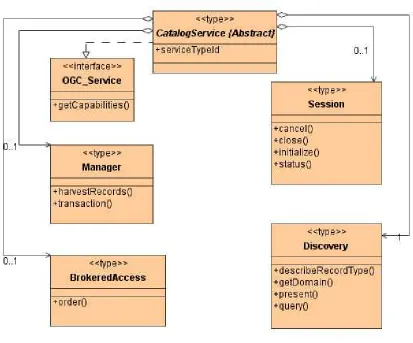
5.3.5 Catalog
• Data Catalogs. The regional data centers will each automatically maintain catalogs of the data and information they contain. When data searches are conducted, the queries will be responded to by data center catalog services and provide the requesters with all relevant information in response to the query. This information will include content parameters such as source and age of the data as well as management data such as when originally stored, last verified and last retrieved. Content metadata will convey the confidence level of data in terms of reliability, currency and accuracy.
A catalog is adatabase of information about geospatial resources (data, services, and related information objects) available to a group or community of users. A catalog typically stores descriptive information about the resource being described, and does not store the information resource itself. The interfaces on catalogs enable services that are collectively referred to as Catalog Services in OGC. We use the term “catalog” or “catalog services” to describe the set of service interfaces that support organization, discovery, and access of geospatial information. Catalog services help users or
application software to find information that exists anywhere in a distributed computing environment. These resources function in this environment through interfaces that implement OpenGIS Specifications. Interaction with geospatial data collections via their metadata is done via catalog services. Catalog services are required to support the discovery and binding to registered information resources within an information community.
5.3.5.1 Catalog components
The General Catalog Interface Model provides a set of abstract service interfaces that support the discovery, access, maintenance and organization of catalogs of geospatial information and related resources. The interfaces specified are intended to allow users or application software to find information that exists in multiple distributed computing environments, including the World Wide Web (WWW) environment. All behavior requiring sessions is expressed by a dynamic model of conversation state and state
transitions. The model expresses the states and messages that trigger the changes in state. An Application Profile is predicated on the existence of one protocol binding in the base specification. In the case of the Catalog Services Specification, a profile could reference CORBA, Z39.50, or HTTP protocol bindings. In most, but not all, protocol bindings, there may be restrictions or refinements on implementation of the General Model agreed within an implementation community.
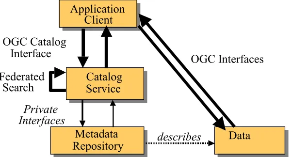
Figure 7 - Catalog Reference Model Architecture, shows the Reference Architecture assumed for development of the OGC Catalog Interface. The architecture is a multi-tier arrangement of clients and servers. To provide a context, the architecture shows more than just catalog interfaces. The bold lines illustrate the scope of OGC Catalog and Features interfaces.
The Application Client shown in Figure 7 - Catalog Reference Model Architecture interfaces with the Catalog Service using the OGC Catalog Interface. The Catalog Service may draw on one of three sources to respond to the Catalog Service request: a Metadata Repository local to the Catalog Service, a Resource service, or another Catalog Service. The interface to the local Metadata Repository is internal to the Catalog Service. The interface to the Resource service can be a private or OGC Interface. The interface between Catalog Services is the OGC Catalog Interface. In this case, a Catalog Service is acting as both a client and server. Data returned from an OGC Catalog Service query is processed by the requesting Catalog Service to return the data appropriate to the original Catalog request.
Figure 7 - Catalog Reference Model Architecture
Resources in a catalog are discovered using a filter. Queries can be temporally constrained using the standard scalar operators found in the Filter specification
not formally define temporal operators at the time; the operators like Inside, Overlaps, etc could be applied to temporal data to achieve this task.
Here is an example of a temporal query finding records modified between two specific dates that uses scalar operators to constrain the "modified" property:
<GetRecords
xmlns="http://www.opengis.net/cat/csw"
xmlns:rim="urn:oasis:names:tc:ebxml-regrep:rim:xsd:2.5" xmlns:ogc="http://www.opengis.net/ogc"
outputFormat="text/xml; charset=UTF-8"> <Query typeNames="rim:ExtrinsicObject"> <Constraint>
<ogc:Filter>
<ogc:PropertyIsBetween>
<ogc:PropertyName>/rim:ExtrinsicObject/rim:Slot[@name="modified"]/rim:ValueList/ri m:Value[1]</ogc:PropertyName>
<ogc:LowerBoundary>
<ogc:Literal>2005-05-24T08-00:00-05:00</ogc:Literal> </ogc:LowerBoundary>
<ogc:UpperBoundary>
<ogc:Literal>2005-05-24T08:30:00-05:00</ogc:Literal> </ogc:UpperBoundary>
</ogc:PropertyIsBetween> </ogc:Filter>
</Constraint> </Query> </GetRecords>
5.3.5.2 Catalog as registry
Catalogs may be used to store information published as a result of a registration process. Such catalogs may reference and describe services, data types or schemas, semantic definitions, vocabularies, namespaces, or other common resources. The intrinsic features of a catalog service now include core registry functions, including:
• Life cycle management of metadata items (i.e. administrative status)
• Flexible classification of metadata items employing user-defined classification schemes (i.e. subject-based metadata)
• Asserting arbitrary relationships among metadata items (i.e. links or cross-references)
• Access control
• Change tracking (i.e. maintenance of audit trails)
• Metadata that describes services, schemas, presentation rules, spatial reference systems, and other shared resources; Reference OGC GEOINT Structure Implementation Profile Schema Processing (07-028) for an example of DDMS 1.3 Metadata for GML.
• Content metadata that characterizes data sets and imagery resources through controlled and uncontrolled vocabularies;
• Links or associations between interdependent resources (or portions of resources);
• Annotations—perhaps transient—that are attached to a resource for a specific purpose or community of users.
A catalog that can accommodate all of these forms of metadata can be used to support a wide variety of discovery scenarios that involve multiple communities of practice.
5.3.5.3 Service publishing
A service catalog, or service registry, is a type of metadata catalog about service instances for use by software and human clients, published as a result of a registration process using pull (harvest) or push (registration API) techniques. A service catalog is thus an instance of an OGC Catalog with an administrative set of interfaces (e.g. add, update, delete) that permit registration of service metadata. Service catalogs can be global or private. Registration acts to publish the presence of a resource, providing for limited search and browsing and general “yellow pages” access. Formal Web Service Registries
are implemented as catalogs of businesses, their services, and operations. Examples of public service catalog approaches include ebXMLi and UDDI, with interface bindings available in various programming environments.
Any service-oriented architecture must support some fundamental interactions:
registering service offers (publishing) and returning service offers upon request according to some criteria (finding). The service catalog provides interfaces for querying and