95
Dengue Hemorrhagic Fever Mapping:
Study Case in Karawang District, West Java Indonesia
Tris Eryando
1*, Dewi Susanna
2, Doni Lasut
3, Dian Pratiwi
31. Biostatistics and Population Study Department, Faculty of Public Health, Universitas Indonesia, Depok 16424, Indonesia
2. Environmental Health Department, Faculty of Public Health, Universitas Indonesia, Depok 16424, Indonesia
3. Center for Biostatistics and Health Informatics, Faculty of Public Health, Universitas Indonesia, Depok 16424, Indonesia
*E-mail: [email protected]
Abstract
The DHF prevention efforts have been continually conducted by the local health office, but some technical obstacles such as surveillance system is still very weak, and this is known as an important part in decision making process to handle the problem using evidence based information. The research objective is to obtain information on dengue endemic mapping through GIS (Geographic Information Systems) to strengthen district surveillance system in district level. Most DHF cases occur in the productive age and located in urban areas with the larva-free rate is low. The direction of movement of the case are local diffusion. Karawang district is a low-lying areas prone to flooding. The rainy season occurs in late October to early May, but the rise of dengue cases at the turn of the rainy season to dry season, this indicates that the humidity in Karawang district supports the mosquito vector breeding. Foging will only kill adult mosquitoes, dengue control programs need to involve community participation and emphasized on public areas like schools and offices because a lot of dengue cases occurred in the productive age. GIS is capable of producing a map factors of risk and map of the case to allow for planning and evaluation of area-based dengue eradication program. GIS is useful in surveillance environmentally based disease, health interventions, and disease prevention strategies.
Abstrak
Pemetaan Penyakit Demam Berdarah Dengue (DBD): Studi Kasus di Kabupaten Karawang, Jawa Barat, Indonesia. Upaya pencegahan DBD terus dilaksanakan oleh dinas kesehatan lokal, meskipun masih didapati sejumlah
kendala teknis seperti sistem surveilans yang masih lemah. Keadaan ini harus diperbaiki karena sistem surveilans telah menjadi bagian penting di dalam proses pembuatan keputusan tentang penanggulangan DBD dengan menggunakan informasi berbasis bukti. Penelitian ini bertujuan untuk memperoleh informasi tentang pemetaan endemis penyakit dengue menggunakan sistem informasi geografis (GIS) untuk mengoptimalkan sistem surveilans di tingkat kabupaten. Sebagian besar kasus menunjukkan bahwa DBD menyerang penduduk usia produktif yang tinggal di kawasan perkotaan dengan tingkat perkembangbiakan jentik yang tinggi. Arah pergerakan penyakit adalah difusi lokal. Kabupaten Karawang adalah kawasan dataran rendah yang rawan banjir. Musim hujan dimulai pada akhir Oktober dan berakhir pada awal Mei, tetapi peningkatan kasus DBD terjadi pada pergantian dari musim hujan ke musim panas. Ini membuktikan bahwa kelembapan di Kabupaten Karawang mendukung perkembangbiakan nyamuk penular DBD. Pengasapan hanya membunuh nyamuk dewasa, dan program pencegahan dengue memerlukan peran serta masyarakat dan harus mengutamakan wilayah publik seperti sekolah dan kantor, mengingat banyaknya kasus dengue pada penduduk usia produktif. GIS mampu menghasilkan peta faktor risiko dan peta persebaran kasus yang dapat digunakan di dalam proses perencanaan dan evaluasi program pemberantasan dengue berbasis wilayah. GIS sangat berguna untuk surveilans penyakit berbasis lingkungan, intervensi kesehatan, dan strategi pencegahan penyakit.
Keywords: dengue hemorrhagic fever, geographics information system, health information system
Introduction
Dengue is found in tropical and sub-tropical. Asia ranks first in number of Dengue patients in each year.
Meanwhile, starting from 1968 until 2009. World Health Organization (WHO) noted the state of Indonesia as the country with the highest cases of dengue fever in Southeast Asia.1 Cases of (DHF) in the
Karawang distric in January to the beginning of August 2009 reached 954 cases. Fourteen people including dying. In accordance with the local Health Department data, the number of dengue cases the year 2009 increased compared to the year 2008, which during the year reached 700 cases and 22 of them died.2
Dengue fever, especially in the Karawang distric of West Java is still a public health problem, the trend of cases from year to year shows a significant number and
Case Fatality Rate (CFR) average of 2%, which makes
the Karawang distric as dengue endemic areas. It happened because of did not know information on the actual dengue endemic areas and the lack of data an accurate estimate of DHF cases in every area of Public
Health Care (PHC). This situation resulted in the
over-expanding area of the case and cause health problems and socioeconomic conditions.3 There are limitations to services resulting from the information system program that has not been going well, causing the information needed by policy makers is less accurate, relevant and not fast enough, resulting in reduction programs DHF problem has not been reached.4
As described above, it can be concluded that the problem is inadequat information on dengue, among others, caused by information dengue control program that runs have been less accurate because of incomplete data, analysis is still a recapitulation of the case, form of reports that are not informative because of the limitations of the analysis, simple mapping of endemic areas has been done but has not produced information that could give the real picture is needed in decision-making. Spatial mapping among health events is an important component in epidemiological and public health study.5 Geographical information system (GIS) adds the dimension of geographic analysis to information technology by providing an interface between the data and a map.6 The GIS has been used to link the spatial and significant sociocultural indicators with the disease data.7 The purpose of this study is obtaining spatial information in order to produce the map of dengue surveillance information, related to the socio-demographic and dengue vector control. Maps would make it possible to plan control measures in high-risk areas and greatly increase the cost efficiency of DHF control programs.8
Methods
Type of the research implemented is observational studies using cross sectional design studies. This study population was all DHF patients in Karawang district as many as 916 respondents, this study using the total cases in the study area. Variables are used, among others, Social and Demographic Variables, larvae free rate, Vector Control Variables, rainfall and respondents point. The data collection for primary data was using
interview techniques, observation and survey on the cases using GPS, which was carried out from April to August 2009.
Gobal positioning system (GPS) surveys, plotting locations using Garmin GPS brands that are available (12 XL, Etrack, Map 76 S, Ique). Case Survey of survey locations Karawang dengue cases in the district as a description of natural phenomena to obtain the absolute location of objects on the earth's surface space by following the rules that apply coordinate projection systems and commonly used for maps in Indonesia in general. Survey larva, which is made plotting the homes of cases and controls house larva Index case of observation in the study.9 Secondary data were sourced from the reports diseases of Karawang District Health Office, it is consisted of sociodemographic data and vector data. Sociodemographic data is data about age and gender of the areas studied. Vector control data include fogging data and epidemiological investigation data (PE), concerned about dengue control programs. Other secondary data are rainfall report from observation stations-Perum Tirta II Division II, Karawang in 2008-2009. Processing and data analysis methods are overlaying and spatial analysis using Arcview 3.3. Research activities beginning with the pre-study or assessment. Assessment aimed at identifying on the territory of cases based on variables taken. The data collection for primary data was using larvae survey to define the house of each village endemic cases and cases and controls for larvae survey. Survey of mosquito larvae by using single methods, which take one fish larvae in each larvae container found there, with detention or plastic scoop or using a long pipette as a sample, for examination of mosquito species (identification). Larvae captured was placed in a small bottle/vial bottle and label in accordance with the survey team numbers, sheet numbers form the basis of: number of surveyed homes and container number in the form.10 The size used to determine the dengue vector larva Index of House Index (HI) and Container index (CI), Breteau Index (BI). Then continued with other activities such as Record the coordinates of a positive house larvae and control cases with GPS devices, save the form (Waypoint) WPT with MapSource software or PCX 5, perform Database Management System (DBMS) among spatial data with attribute data. Attribute data using MS Excel or MS software. Access and stored in the same format with the format of GIS Software in this case, using Arcview 3.3.11 Entering the data into the Arcview 3.3 project and creating a thematic map in the form of mosquito distribution data entities.
Results and Discussion
Socio Demographics. In general, most DHF patients
school children in the age of 10-15 year (18,2%) and worker 59,3% (Table 1).
DHF cases. Karawang Barat and Teluk Jambe Timur
are still the sub district with the largest number of DHF cases. The Figure 1 show there is an Dengue-prone areas are the urban areas.
Case fatality rate (CFR). Talagasari and Teluk Jambe
Barat is the sub district with the highest fatality rate of DHF, CFR >6.5% (Table 2). This indicates a lack of knowledge in handling dengue.
Larva free rate. The Figure 2 below show the
larva-free rate known as Angka Bebas Jentik (ABJ) in Karawang district, ABJ low (<80%) consists of 17
Table 1. DHF Cases by Gender and Age Group Variable Total Cases = 916
Categories Number % Sex Male 483 52 Female 433 48 Age <1 year 4 0.4 1-4 year 56 6.1 5-9 year 146 15.9 10-15 year 167 18.2 >15 year 543 59.3
Figure 1. DHF Case in Karawang District
districts, 56% Karawang Barat, Kota baru 69.89%, 76.50% Karawang Timur, Jayakerta 77.88%, 81.60% Majalaya, Klari of 83.38%, Telukjambe Timur 83, 60%, 85.77% Banyusari, Rawamerta amounted to 85.92%, 86.71% Cilamaya Kulon, Ciampel 87.14%, 87.29% Purwasari, Pakisjaya 88.25%, 88.63% Base, Tegalwaru 89.78 % and 90% Teluk Jambe Barat.
Vector control. If there are suspected cases of dengue
fever, the initial process is conducted epidemiological studies known as “Penyelidikan Epidemiologi” (PE) or research larvae at least in the top house. The criteria is the presence of a positive PE patients with fever and Aedes aegypti mosquito larvae found in the area, the next step is filing process and fogging.
In Table 3 it can be seen, of all cases are found, almost entirely as many as 97.1% conducted the PE foging equitable proportion in each district is <33.33%, although not all cases done foging.
Table 2. Distribution of Dengue Cases and CFR
Sub District DHF Cases CFR
(%) Recovered Dead Number
Banyuasih 13 0 13 0.0 Batujaya 3 0 3 0.0 Ciampel 15 1 16 6.3 Cibuaya 5 0 5 0.0 Cikampek 49 1 50 2.0 Cilamaya Kulon 3 0 3 0.0 Cilamaya Wetan 8 0 8 0.0 Cilebar 5 0 5 0.0 Jatisari 16 0 16 0.0 Jayakerta 14 0 14 0.0 Karawang Barat 201 0 201 0.0 Karawang Timur 75 2 77 2.6 Klari 45 3 48 6.3 Kota Baru 49 1 50 2.0 Kutawaluya 11 0 11 0.0 Lemah Abang 11 0 11 0.0 Majalaya 10 0 10 0.0 Pangkalan 7 0 7 0.0 Pedes 8 0 8 0.0 Purwasari 35 0 35 0.0 Rawamerta 17 0 17 0.0 Rengasdengklok 46 1 47 2.1 Talagasari 15 1 15 6.7 Tegal Waru 2 0 2 0.0 Telukjambe Barat 10 2 12 16.7 Telukjambe Timur 188 1 189 0.5 Tempuran 11 0 11 0.0 Tirtajaya 12 0 12 0.0 Tirtamulya 17 0 17 0.0 Dawuan Timur 0 0 0 0.0 Pakis Jaya 3 0 3 0.0 Total 903 13 916 1.4
Figure 2. Larva-free Rate
Figure 3. Rainfall in Karawang
Table 3. Vector Control per Sub District Sub District DHF Cases Vector Control Fogging % PE % Banyusari 13 3 23.08 13 100.0 Batujaya 3 0 0.00 3 100.0 Ciampel 16 2 12.50 13 81.3 Cibuaya 5 0 0.00 5 100.0 Cikampek 50 2 4.00 46 92.0 Cilamaya Kulon 3 0 0.00 3 100.0 Cilamaya Wetan 8 0 0.00 8 100.0 Cilebar 5 0 0.00 5 100.0 Dawuan Timur 0 1 6.25 0 0.0 Jatisari 16 3 21.43 15 93.8 Jayakerta 14 19 9.45 14 100.0 Karawang Barat 201 4 5.19 199 99.0 Karawang Timur 77 3 6.25 74 96.1 Klari 48 4 8.00 46 95.8 Kotabaru 50 0 0.00 48 96.0 Kutawaluya 11 0 0.00 11 100.0 Lemahabang 11 2 20.00 11 100.0 Majalaya 10 0 0.00 10 100.0 Pakisjaya 3 2 25.00 3 100.0 Pangkalan 7 0 0.00 7 100.0 Pedes 8 3 17.65 7 87.5 Purwasari 35 4 8.51 32 91.4 Rawamerta 17 2 13.33 16 94.1 Rengasdengklok 47 0 0.00 46 97.9 Talagasari 15 2 16.67 15 100.0 Tegalwaru 2 11 5.82 2 100.0 Telukjambe Barat 12 0 0.00 12 100.0 Telukjambe Timur 189 0 0.00 188 99.5 Tempuran 11 1 5.88 11 100.0 Tirtajaya 12 0 0.00 10 83.3 Tirtamulya 17 0 0.00 16 94.1 Total 916 68 7.42 889 97.1
Rainfall (climate). Months with rainfall <60 mm
including the dry months and months with rainfall >200 mm included in the wet months, while the month with rainfall 60-200 mm included in the humid months.12. The Figure 3 show the highest monthly rainfall average is Cilamaya wetan (>200 mm) and the lowest is Cikampek (<60 mm). Rainfall received in the northern region Karawang regency is higher when compared with other regions.
Maximum rainfall occurs in February and minimum in July, with the highest rainfall in the north there is the Karawang regency. The climate linkages in this case related rainfall and DHF incidence can be seen in the Figure 4.
Dengue Hemorrhagic Fever incidence early in the humid October through December there has been no case, in January began a high case until April and peaks in the case occurred in May and so on down until September as the decrease in monthly rainfall.
Oct Nov Dec Jan Feb Mar Apr May June July Agt Sept
Rain fall rate 53 96 142 193 676 110 115 51 39 0 29 3
DHF Case 0 0 0 58 72 57 71 130 104 60 38 0
Figure 4. Climate (Rainfall) and DHF Case Linkage
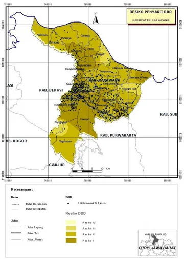
Figure 5. Dengue Risk Area
Dengue risk area. Based on the data found, so we get a
map of risk areas, such as the following figure. Dengue risk areas are: Karawang Barat and Teluk Jambe Timur, because both regions have larva free rate low (<80%)
and an area with high rainfall that need special attention in the dengue control program, because Karawang District is still an endemic area of dengue in Indonesia. Aspects of Patients' age demographic most at risk, aged 15-44 years old. Mosquito Ae. aegypti bites during the day in which the activities performed by these age groups is to school and work. Such places as public so that schools and offices have received attention in the DHF treatment program. Karawang Barat and Teluk Jambe Timur are the dengue risk area with the highest dengue cases, these two regions also have larva-free rate known as Angka Bebas Jentik (ABJ) is low (<80%). The high index of larvae, a factor supporting the transmission of DHF disease. Dengue-prone areas are the urban areas.
Case fatality rate (CFR) is highest in Rengasdengklok and Tirtajaya, this indicates a lack of knowledge and awareness in the handling of dengue, besides That there are still some People who have Not Implemented even though it was done "Eradication of mosquito breeding counseling" known as "PSN counseling". Fogging only kills adult Mosquitoes and mosquito larvae used to kill the abate. Some previous studies stated that dengue vectors is influenced by climatic factors, especially rainfall.13-14 In karawang district maximum Rainfall Occurs in February, and minimum rainfall Occurs in July, the highest rainfall in the north there is the Karawang regency. Beginning of the rainy season in Karawang district is among the second week and the month of october, first week in november. Rainfall at high, where mosquitoes lay their eggs will carry over water, when the change of seasons with little rainfall so many puddles of water and humidity increases, this condition affects the propagation vector and the increasing incidence of DHF. Age of female mosquitoes
1 10000 2 20000 3 30000 4 40000 5 50000 6 60000 7 70000 8 80000 O O NN DD JJ FF MM AA MM JJ JJ AA SS
ranged from 2 weeks to 3 months or an average of 11/2 months depending on temperature and humidity of the air around it. Another problem is worrying that the eggs of Ae. aegypti can survive up to six months even in a dry place and not in the water. If the egg is exposed to water in a certain time, he would multiply the wiggler. That is why in the dry season there is still the incidence of dengue. It is in line with research by Yanti (2004),15 which states the number of rainy days and heavy rainfall will result in flood that would sweep over the place brood mosquitoes. While the number of rainy days a little and high rainfall with a long time, will add a place brood of mosquitoes and increase the mosquito population.
Conclusions
Most DHF cases occur in the productive age and located in urban areas with the larva-free rate is low. The direction of movement of the case are local diffusion. The rainy season occurs in late October to early May, but the rise of dengue cases at the turn of the rainy season to dry season, this indicates that the humidity in Karawang district supports the mosquito vector breeding. Dengue risk areas are Karawang Barat and Teluk Jambe Timur, The map of risk area is useful in surveillance "environmentally based disease", health interventions, and disease prevention strategies in very specific local condition.
Acknowledgements
We would like to thank the Directorate of Research and Community Service of Universitas Indonesia for National Strategic Research Grant with contract No.407Y/DRPM-UI/A/N1.4/2009, with the title: “Pemetaan Wilayah Endemis DBD dengan GIS sebagai bagian Sistem Informasi Surveilans di Kabupaten Karawang-Jawa barat Tahun 2009”.
References
1. Sudarianto. Waspada demam berdarah. Sulawesi Selatan: Dinkes Sulsel; 2009.
2. Rommy P. DBD swallow 14 soul sacrifice in
Karawang. Jakarta: Media Indonesia Press; 2009.
3. Dinas Kesehatan Karawang, Laporan kasus DBD
tahun 2007-2009, Karawang: Dinas Kesehatan
Karawang, 2009.
4. Eryando T, et al.. Pemetaan wilayah endemis DBD
dengan GIS sebagai bagian sistem informasi surveilans di Kabupaten Karawang Jawa Barat tahun 2009. Depok: DRPM UI; 2009.
5. Er AC, Rosli MH, Asmahani A, Mohamad-Naim MR, Harsuzilawati M. Spatial mapping of dengue incidence: A case study in Hulu Langat District, Selangor, Malaysia. Int. J. Human Soc. Sci. 2010;5(6):410-414.
6. Nazri CD, Rodziah I, Hashim A. Distribution pattern of a dengue fever outbreak using GIS, J.
Environ. Health Res. 2009;9(2):89-96.
7. Bohra A, Andrianasolo H. Application of GIS in modeling of degue risk based on sociocultural data: Case of Jalore, Rajasthan, India, Dengue Bull. 2001;25:92-102.
8. Pathirana S, Kawabata M, Goonetilake R. Study of potential risk of dengue disease outbreak in Sri Lanka using GIS and statistical modelling, J. Rural
Trop. Public Health, 2009;8:8-17.
9. Dinas Kesehatan Provinsi Jawa Barat. Situasi P2
DBD Provinsi Jawa Barat tahun 2003-2004.
Bandung: Dinas Kesehatan Provinsi Jawa Barat, 2005.
10. Departemen Kesehatan RI. Petunjuk teknis standar
pelayanan minimal bidang kesehatan di kabupaten/kota: Pencegahan dan pemberantasan penyakit demam berdarah dengue (DBD) penderita DBD yang ditangani. Jakarta: Depkes RI, 2004.
11. Prahasta E. Tools dan plug ins Arcview GIS. Bandung: Informatika; 2003.
12. Sandy IM. Iklim regional Indonesia. Jakarta: Jurusan Geografi FMIPA, Universitas Indonesia; 1987.
13. Gemiwati W. Hubungan faktor-faktor iklim, angka
bebas jentik dan angka insiden demam berdarah dengue di Kota Pekanbaru tahun 1995 sampai dengan 2001 [Tesis Magister]. Depok: Fakultas
Kesehatan Masyarakat, Universitas Indonesia; 2003.
14. Hopp MJ, Foley JA. Global-Scale relationships between climate and the dengue fever vector,
Aedes egypti. Clim. Change 2001;48:441–463.
15. Yanti SE. Hubungan faktor-faktor iklim dengan
kasus demam berdarah dengue di Kotamadya Jakarta Timur Tahun 2000-2004 [Skripsi Sarjana].
Depok: Fakultas Kesehatan Masyarakat, Universitas Indonesia; 2004.