Key words Ionian Sea –chirp sonar –echo char-acter –coral mound –mud volcano
1. Introduction and geological setting
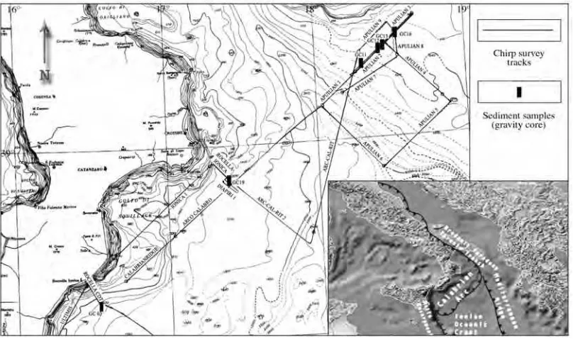
In March 2002 a cruise onboard the R/V Urania, collected about 1100 km of Chirp 2 sonar profiles in the Ionian Sea, from the inner parts of the Calabrian Arc accretionary prism to the Apulian foreland, crossing the Taranto Trench (fig. 1). Part of the chirp data were col-lected along a trackline which follows CROP
seismic line M5, oriented SW-NE (Doglioni et al., 1999; Merlini et al., 2000). A chirp sonar grid has been acquired off-shore Puglia, where living deep water corals (n.d.r. Lophelia per-tusa) have been recently dredged (Tursi and Mastrototaro, pers. comm.).
According to several authors (Gasparini et al., 1982; Cristofolini et al., 1985; Malinver-no and Ryan, 1986; Royden et al., 1987; Patac-ca and SPatac-candone, 1989; BocPatac-caletti et al., 1990; Doglioni et al., 1994, 1996; Selvaggi and Chia-rabba, 1995) the Apennines belt is the result of the eastward retreat of the Adriatic-Ionian litos-phere, during the last 30 Ma. The Southern Apennines and Calabria, located in the most ar-cuate part of the belt, migrated eastward at the fastest rates (about 3-4 cm/yr, Patacca and Scandone, 1989; Patacca et al., 1990; Doglioni, 1991).
Evidence of mud diapirism
and coral colonies in the Ionian Sea
(Central Mediterranean) from high
resultion chirp sonar survey
Nicoletta Fusi, Alessandra Savini and Cesare Corselli Dipartimento di Scienze Geologiche e Geotecnologiche,
Università di Milano «Bicocca», Milano, Italy
Abstract
A chirp sonar survey in the Ionian Sea investigated the Calabrian margin, the Calabrian accretionary wedge, the Taranto Trench and the Apulian foreland. Shallow tectonic structures have been related to deeper ones, recog-nised on CROP seismic profiles. The identified echo characters have been compared with those described in the modern literature and have been related to different kinds of sediments, on the basis of core samples. Based on echo character and morphology we have recognised: 1) A widespread presence of mounds, up to 50 m high, oc-curring on the Apulian plateau as isolated mounds in the deepest zones (1600-800 m) and in groups in the shal-lower ones (800-600 m); they have been interpreted as coral mounds, according to a recent discovery of living deep water coral colonies in this zone. 2) Some mud diapirs, isolated or in groups of two or three elements, wide-spread in the whole study area. Similar to what has been observed on the Mediterranean ridge, their presence suggests the activity of deep tectonic structures (thrusts and faults) and a reduced thickness (or absence) of Messinian evaporites in this part of the Ionian Sea.
The Apennine belt consists of thrust sheets of the sedimentary cover (Mostardini and Mer-lini, 1986; Sella et al., 1988; Patacca and Scan-done, 2004), later cross-cut by deep normal faults, along which fluids migrate upwards (Do-glioni et al., 1996). The Southern Apennines belt is marked by compressive thin-skinned tec-tonics at the front and to the east and extension-al thick-skinned tectonics in the main chain and to the west of it (Merlini et al., 2000).
Seismic line M5, underlying our chirp sur-vey, runs from off-shore Eastern Calabria to off-shore Southern Puglia and is considered one of most representative lines of the Italian proj-ect CROP (Doglioni et al., 1999). On the Cal-abrian margin this section crosses extensional faults, which inland are well known to form grabens (Val d’Agri, Vallo di Diano; Merlini et al., 2000) and are responsible for the high seismicity of the Southern Apennines (Amato and Selvaggi, 1993); on the eastern side the sec-tion crosses the Apulian swell which appears
rather as a 100 km wide buckling anticline, de-forming the entire lithosphere (Merlini et al., 2000).
Objectives of our study are: 1) to identify the main shallow active tectonic structures; 2) to integrate these structures into the regional framework, defined by deeper seismics (CROP seismic line M5); 3) to eventually relate region-al fluid flow with the presence of living corregion-al colonies and with active tectonics.
2. Methods
The chirp survey was carried out using the ship’s DATASONIC DSP-661 Chirp 2 Profiler. Trigger rates varied from 2 to 4 s, depending on water depth, ranging from about 600 m to about 2500 m; the spectrum of frequencies of sound signal is between 3 to 7 kHz. The chirp survey was carried at a rather constant speed of about 10 knots, except for the lines on the Apulian
plateau, where our main interest concentrated, which where carried at a lower speed of 4 knots. Data were displayed on an EPC 9800 and recorded on Magneto-optical disks in SEG-Y format, with the exception of the first part of line Calabrian ridge, which was not recorded due to technical problems. Synchronization of this instrument with the navigation system (NAVPRO) allows precise location of structures on chirp profiles and precise localization for core sampling sites (gravity cores, fig. 1). Sement samples were collected with a 10 cm di-ameter gravity corer at 6 stations (fig. 1); data from multi-corer, used mainly for biological in-terest, were also taken into account.
The digital chirp data were initially proces-sed with suitable software to provide a useful im-age with proper geographic locations of features identified in the imagery. The processing steps included the replying data in several different vertical distance range windows, applying image corrections and digitising sub-bottom. The im-agery was then visualised in its proper geograph-ic location and exported from the software pack-age as TIFF impack-ages with associated georeference information.
The chirp profiles yield a detailed image of the surficial structure up to 100 ms twt (corre-sponding to 80 m of sediments, using an interval velocity of 1600 m/s) depending on seafloor dip and characteristics. The interpretation of seismic facies identified on chirp profiles was compared with those identified by other authors (Damuth and Hayes, 1977; Damuth, 1980; Lee et al., 2002) and ground truth by means of core logs.
3. Results and discussion
The chirp survey (fig. 1) crosses the follow-ing structural domains, from SW to NE: the Calabrian margin, the accretionary wedge, the Taranto Trench and the Apulian foreland.
The seismic section identified by means of chirp profiling can be referred to Plio-Pleistocene units on the Calabrian margin, the accretionary wedge and the Taranto Trench, whereas on the Apulian plateau Neogene – Pleistocene units out-crop, forming the Apulian swell; for stratigraph-ic and structural interpretation of CROP seismstratigraph-ic
line M5 we refer to Doglioni et al.(1999) and Merlini et al.(2000). Seismic facies were related, if possible, to echo types identified by Lee et al. (2002) and indicated following their nomencla-ture (roman number +arabic one).
3.1. Calabrian margin
In this area the Chirp 2 system has generally a good penetration, ranging from 50 to 75 ms twt. The seismic sequence is characterised by strong reflectors alternating with transparent intervals, which mantle the topography, pinching out on the top of topographic highs. Prevalent echo type of this area can be attributed to type I-2.
This part of the seismic section is charac-terised by widespread dip-slip faults, which off-set the seafloor for several hundred meters, the total throw of the Calabrian margin being of about 1500 m. These faults cross-cut both the Plio-Quaternary sedimentary successions and the buried pre-Messinian back-thrusts (see fig. 3 of Merlini et al., 2000); their activity seems thus to be Plio-Quaternary. This active tectonics results in an articulated topography, with sever-al horsts (off-shore Punta Stilo and Rocella Ion-ica) mantled by sediments (fig. 2).
The steepest flanks of horst structures (about 1.5° gradient) are affected by mass movements: landslide scarps, about 20 m high, can be identi-fied, due to sharply truncated reflectors. Land-slide deposits, with chaotic reflectors inside, (type IV-1) extend for about 8.5 km, both on the lower part of the slope and in the basin. Land-slides seem to involve only the superficial and probably unconsolidated part of the sedimentary succession.
Fig. 2. Chirp profile across the Calabrian ridge (Calabrian ridge line – see fig. 1 for location), with the insets of the main structural features identified (A, B, C). A – example of a canyon; B – onlapping reflectors on the top of a horst; C – landslide scarp on the steepest flanks of horst structures and relative deposits.
these mounds, recovered no sediments at all, thus confirming the total lack of soft sediments on the top of the mounds. On the basis of seis-mic response and morphology they are inter-preted as mud volcanoes.
3.2. Accretionary wedge
The accretionary wedge is characterised by a rough topography, ranging between 1400 m and 2000 m depth. The shallow sediments are gently deformed by symmetrical and asymmetrical waves, referred to echo type III-3 and interpret-ed as the result of creeping on the slope of the accretionary wedge; some patches of debrites (echo type III-2) are also present. Steep flanks are characterised by slumps (fig. 4).
A distinctive character of this area is a flat plateau, delineated by 1600 m and 1800 m iso-baths and gently dipping south-eastward (0.2°), here called Punta Stilo plateau (fig. 4). It is char-acterised by an abrupt change in seismic charac-ter: the sea bottom is highly reflective and reflects nearly all the acoustic energy; only occasionally very few reflectors can be identified below sea bottom (echo type I-1). Micro undulations of the sea bottom of this plateau (echo type III-2) are visible only on Arco Calabro line (SE-NW). Pun-ta Stilo plateau is interpreted as the outcropping of more resistant lithologies. We suggest that these lithologies are coarse grained turbidites, on the basis of «Rocella» core, which recovered sev-eral meters of mud intercalated with sandy layers; this interpretation is supported by other seismic surveys in this area, which outline the pinching
out of reflectors below the sea bottom, suggesting lobate and basin-fill geometry of deposits (Merli-ni, pers. comm.). The origin of sediments in-volved in turbidites is probably the steep conti-nental margin off-shore Calabria.
3.2.1. Geophysical evidence of mud volcanism Several transparent mounds, 100-150 m high and from 2000 m to 3500 m across, have been identified. They occur in small groups of two or three elements and in many cases they present asymmetric flanks; they can be mantled by sedi-ments, sometimes characterised by slumpings (fig. 4). Dimensions of the mounds are consistent with the mud volcanoes and mud cones identi-fied on the Mediterranean ridge (Camerlenghi et al., 1992, 1995; Limonov et al., 1994; Fusi and Kenyon, 1996 among others). Two of these mounds were investigated by a detailed survey, that included sampling. Core GC 19, taken on top of one mound (fig. 1), recovered only soft mud, alternated with a tephra layer and some sandy layers; it can thus be inferred that the mud breccia, if present, is buried below several meters of layered sediments, as suggested by reflectors on top of the mound.
A peculiar morphologic and seismic feature of this area is an U-shaped valley, here called Thorgatten, about 130 m deep (fig. 4); sub-hori-zontal reflectors can be seen on its flat bottom, about 3.5 km wide. It is bordered by two acousti-cally transparent mounds, interpreted as mud vol-canoes, presenting steep internal flanks, whereas the outer flanks are characterised by dipping re-flectors sometimes chaotic, due to slumping. The Thorgatten lies on the outcrop of the minor south-westward verging thrusts, identified on CROP line M5. A similar relationships between mud volcanoes and compressive deep tectonics has been delineated on the Mediterranean ridge (Ca-merlenghi et al., 1995).
Although we did not observe any chimney cross cutting the sedimentary sequence below the mud volcanoes, we did observe (fig. 4) a typ-ical character of mud volcanoes worldwide, that is the ring shaped depression filled by re-deposit-ed sre-deposit-ediments surrounding the volcano (see fig. 15 of Camerlenghi et al., 1995).
The presence of mud volcanoes on the Cal-abrian ridge was already known: some few small isolated mud cones were identified by means of a discontinuous side scan sonar survey (GLORIA; Fusi and Kenyon, 1996); they have a round shape and seem to recur as isolated spots, whereas on the Mediterranean ridge mud volca-noes are found in groups, of different shapes and dimensions, on the northern edge of the ridge (Camerlenghi et al., 1992, 1995; Limonov et al., 1994; Fusi and Kenyon 1996); mud volcanoes on the Calabrian ridge are generally smaller than those on the Mediterranean ridge (see fig. 3 of Fusi and Kenyon, 1996). On the basis of GLORIA data (Fusi and Kenyon, 1996) it can be hypothesized that most mud volcanoes on the Calabrian ridge are circular or sub-circular, but it cannot be excluded that some of them, espe-cially those located along thrust planes, such as Thorgatten, are mud ridges.
3.3. Taranto Trench
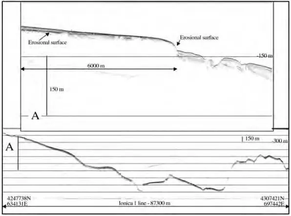
The Taranto Trench appears as an almost symmetrical depression (fig. 1), about 2500 m deep (fig. 5) and about 9.5 km wide; both NE and SW slopes of the trench have the same gradient (about 18°). Its axis, which follows the outcrop-ping of the accretionary wedge front, has an apenninic direction (NNW-SSE) in this part of the Ionian Sea. Along its axis, the topography of the Taranto Trench is characterised by two main steps of about 200 m each at 2800 m and 2700 m depth (fig. 6). The deepest part of the line is char-acterized by sharp surface echo, with no sub-bot-tom reflectors, referred to echo type I-1. The flat area starting after the second steps, from 2600 m to 2400 m depth shows two main characteristics: a) reflectors, generally mantling the topography but in some cases pinching out on small mounds; b) small basins, about 1 km wide and 50 m deep, filled up by about 20 m of sediments. The upper part of the trench is characterised by a hum-mocky topography with some chaotic reflectors, referable to echo type IV-3, interpreted as inter-layered debrites and turbidites.
Fig. 5. Chirp profile across the Taranto Trench and the eastern section of Apulian plateau (Apulian 1 line – see fig. 1 for location), that rises through westward dipping deep seated faults. The zoom shows the sharp surface echo, with no sub-bottom reflectors, that characterised the Taranto Trench.
seismic line M5 in the Taranto Trench, which on-lap the Apulian platform, suggest different tur-biditic episodes. Turbidity currents, probably originating from the inner parts of the Taranto Gulf, are channelled along the Taranto Trench axis, eroding in part former deposits and filling small basins.
3.4. Apulian plateau
The Apulian plateau rises from more than 2400 m to about 200 m depth through several westward dipping deep seated faults, with a total throw of about 1500 m, also affecting the sea-bot-tom. Merlini et al. (2000) tentatively interpret these south-western scarps on the Apulian plateau as an example of foreland inversion and thus they hypothesise two thrust planes (fig. 5 of Merlini
et al., 2000). On chirp we have no evidence of such faults.
Few probable mud volcanoes were identi-fied on the slope toward the Taranto Trench and are probably related to these deep seated struc-tures. In this area the seismic signal has no pen-etration, due to the steepness of relief. The dif-fuse presence of irregular overlapping hyperbo-lae (echo type III-1) prevents identifications of the regional westward dipping monocline visi-ble on CROP line M5.
At about 500 m depth, three antiforms can be recognised on chirp profiles (figs. 7 and 8); their axis is appeninic (NNW-SSE) and parallel to the main dip slip faults of the Apulian Plateau. The first one from SW is the more evident, both from bathymetry and from seismics. The chirp survey suggests an asymmetric antiform, with its NE flank mantled by reflectors, 50 ms thick,
Fig. 8. Chirp profile across the Apulian plateau (Apulian 9 line – see fig. 1 for location), with the zooms (A, B) of the main geophysical features that characterise the mound fields recognised in this area. See on zoom B the highest transparent mound identified on Apulian plateau.
Fig. 10. Chirp profile across the Apulian plateau (Apulian 4 line – see fig. 1 for location), with the zooms of the main geophysical features that characterise the mound fields recognised in this area (A, B) and the diapiric intrusions (C).
ping the crest of the structure and probably dis-rupted by a normal Apenninic fault, which could be interpreted as a conduit for fluid expulsion (see 3.4.1). The south-western flank of this struc-ture presents sub-horizontal reflectors, truncated by a sharp erosional surface at about 750 m depth; the outcrop or subcrop of old consolidat-ed sconsolidat-edimentary successions can be reasonably supposed. On the top of this anticline small re-verse faults were identified, suggesting a recent activity of this structure. This structure (figs. 7 and 8) can be recognised also on CROP line M5, where it is underlined by two reverse faults which isolate a wedge, extruded upward. These reverse faults seem to affect both the Mesozoic Apulian Carbonate platform and the Neogene-Pleistocene sediments (fig. 6 of Merlini et al., 2000).
A gravity core taken at the top of this anti-cline structure (GC 13, 666 m depth) recovered 261 cm of mud, stiffer toward the bottom of the core, with pteropod fragments and foram tests in the upper 13 cm (fig. 9). This structure is fol-lowed to the NE by two other antiforms, less
ev-ident from their morphology, but still ev-identifiable by seismics (fig. 8).
On the basis of chirp data we interpret both the three anticlines and the reverse faults as mi-nor structures, ductile and tensile respectively, connected to the Apulian lithospheric anticline.
as-suming this hypothesis, the sediment deforma-tion rate is higher than the sedimentadeforma-tion rate.
4. Geologic and structural interpretation of the study area
A synthetic structural-geological map and a cross section of the study area were produced (figs. 11 and 12) on the basis of: a) the echo characters and shallow structures identified on chirp survey; b) core logs collected as ground truth data; c) deeper seismics (CROP line M5) and its structural interpretation.
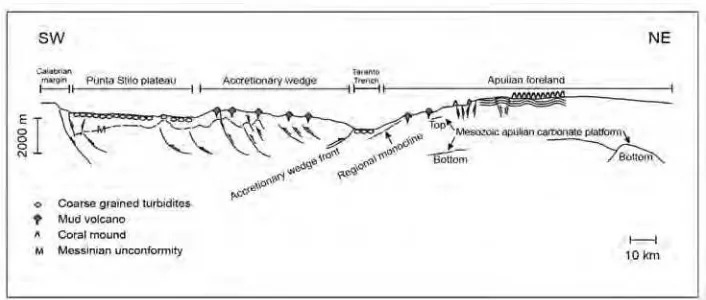
The transition between the extensional tec-tonics of the Calabrian margin and the compres-sive tectonics of the accretionary wedge is repre-sented by the Punta Stilo plateau (figs. 11 and 12), dominated by the sedimentation of coarse grained turbidites and not affected yet by active tectonics. This plateau can be interpreted as a sort of huge talus, which collect coarse sediments, de-riving from the erosion and mass movements from the steep Calabrian margin and from the main land.
The accretionary wedge, marked to the front by an eastward verging thrust, is topographical-ly and structuraltopographical-ly deeper than the foreland and
is mainly subsiding (Doglioni et al., 1999; Mer-lini et al., 2000). On chirp profiles there is no sign of the compressive tectonics identified on CROP line M5 and in particular of the accre-tionary wedge front, but the widespread pres-ence of creep deposits and debrites suggests a recent activity of this area.
The Apulian foreland, separated from the ac-cretionary wedge by the narrow Taranto Trench, filled up by coarse turbidites, is folded by a 100 km wide crustal-lithospheric anticline, currently uplifting (Merlini et al., 2000). Superficial anti-clinal folds and reverse faults identified on chirp profiles (figs. 7, 11 and 12) are interpreted as mi-nor tensional and ductile compressive structures, connected with the hinge zone of the Apulian lithospheric anticline.
In the study area mud volcanoes do not seem to be related to any particular geodynamic con-text, since they occur both on the accretionary wedge and on the margin of the Apulian foreland (see 4.4.2). This difference from the Mediter-ranean rigde, where deep origin mud volcanoes occur only at the NE edge of the ridge due to re-duced thickness of Messinian evaporites and to the presence of thrusts (Camerlenghi et al., 1995) suggests that: a) the source rock is not as deep as on the Mediterranean ridge or there are possibly different source rocks at different depths; in fact, according to well logs (Merlini, pers. comm.), different age clays are widespread in all this area; b) mud diapris are related to deep seated tectonic
structures, such as thrusts and/or dip slip faults. c) Messinian evaporites are absent or highly re-duced in thickness, as suggested both by well logs on the mainland (Casero, 2004) and seismic sections, where a Messinian unconformity can be traced on the Calabrian margin and on the accre-tionary wedge (Doglioni et al., 1999; Merlini et al., 2000). In the Ionian sea the only deep well drilled (ODP Site 964 on the Pisano plateau) re-covered 112 m of Plio-Pleistocene nannofossil ooze (Shipboard Scientific Party, 1996), adding no further information to the presence/absence of evaporites.
5. Geophysical evidence of coral mounds
The Apulian plateau is characterised by the widespread presence of transparent mounds, about 20 m high and 200-300 m large each; they occur as isolated mounds on the top of the fault steps in the deepest zones (1600-800 m – fig. 7) and become widespread from 800 m depth up, both in groups and as single mounds separated by reflectors. In some areas the mounds are un-derlined by concave downward reflectors, re-peating the morphology of the mounds them-selves. A particularly high (about 50 m) transpar-ent mound was idtranspar-entified at a depth of about 750 m (fig. 8). Three gravity cores have been collect-ed on these mounds (figs. 1 and 7). Core GC 11, taken on a fault step with a transparent mound, at
1170 m depth recovered only 93 cm of brown mud. Core GC 12 (800 m depth), taken on an isolated transparent mound, and core GC 16 (750 m depth), taken in the area of widespread transparent mounds, recovered respectively: 100 cm of grey mud with forams and pteropods at the top and coral fragments in the upper 40 cm; 341 cm of mud, with forams and pteropods at the top (fig. 9).
These mounds are here interpreted as coral mounds, on the basis of their acoustic and mor-phological characters. In fact, due to the high reflectivity at their top, reef structures mask the acoustic response further down, appearing thus transparent. Furthermore, these transparent mounds rise from the sea bed with a relatively high angle, that is about 50°, as described also for Norwegian reefs (Hovland and Thomsen, 1997). Seismic data are supported by the recent discovery in this area of dredged living corals (Tursi and Mastrototaro, pers. comm.) and of coral fragments in core GC 12.
Hovland and Thomsen (1997) proposed that the presence of cold deep water coral could be as-sociated with microseepage from the seabed of light hydrocarbons which provide nutrients for bioconstructor organisms. Coral colonies be-come widespread from the apenninic dip slip fault disrupting the anticline (fig. 7); this part of the Apulian plateau is intensively fracturated by conjugate dip slip faults affecting the Neogene-Pleistocene sedimentary sequence (Merlini et al., 2000) and providing a local micro-seepage through the seabed of light hydrocarbons, useful for the life of cold water corals (Hovland and Thomsen, 1997).
The areal extension and shape of coral co-lonies is currently unknown. On the basis of our survey, the area characterised by the presence of coral mounds should cover about 250 km2
. In any case, this coral site on the Apulian plateau seems to be one of the more extended and richer deep water coral site of the Mediterranean Sea and is worth additional detailed investigations.
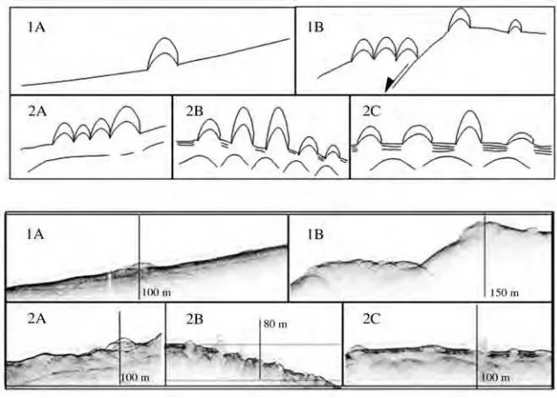
According to our survey coral mounds are present in two main different scenarios (fig. 13):
1) On the slope of the Apulian swell rising from the Taranto Trench, in water depth as deep as 1600 m, coral mounds occur as: a) isolated mounds, located on the slopes; in this case no deep structure can be reliably connected with bio-hermes and probably these bio-constructions can be seen as a sort of pioneer organisms; b) small groups of several bioconstructions; their presence is strictly related to the dip slip fault steps, which offset the slope of the Apulian swell in this area. We infer that the presence of coral reefs at this water depth is connected to fluids rising along faults and providing a food source for suspension-feeders, such as corals (Hovland and Thomsen, 1997).
2) In the shallower part of the Apulian pla-teau, from about 700 to 400 m water depth, coral mounds are widespread, covering an area of at least 250 km2
; furthermore, coral reefs are locat-ed immlocat-ediately above a nearly surfacing up-dip-ping and high-reflective layer, that can be inter-preted as partly gas charged and an upward mi-cro-seepage site (Hovland and Thomsen, 1997). They can occur as: a) groups of several tens of high reflective mounds, cross cutting each other, below which no reflector can be detected. Due both to concentration of reefs and to their partic-ular height (up to 50 m) we interpret this scenario as characterised by fast growing bio-construc-tions; b) groups of several tens of high reflective mounds, cross cutting each other, underlined by upward convex reflectors, interpreted as dead coral reefs. This context suggests superimposed cycles of biohermes; it can thus be inferred that the presence of corals in this area is long lasting; c) small coral mounds, few meters high, separat-ed by pondseparat-ed sseparat-ediments; one of this coral reefs grows on one small fault, offsetting the sea bot-tom, with a throw of about 3 m. We interpret this situation as isolated, relatively slow growing bio-constructions, separated by ponded sediments.
6. Conclusions
The peculiarity of the study area is the pas-sage from an extensional tectonic regime abrian margin) through a compressive one
(Cal-abrian ridge) to a stable zone (Apulian fore-land). The main results of our chirp survey in this area are the following:
1) The transition between the extensional tectonics of the Calabrian margin and the com-pressive tectonics of the accretionary wedge is represented by a wide flat plateau (Punta Stilo plateau), gently dipping south-eastward (0.2°) and dominated by the sedimentation of coarse grained turbidites; no evidence of active tecton-ics can be identified on this plateau.
2) Superficial anticlinal folds and reverse faults, identified on the Apulian plateau, are in-terpreted as minor tensional and ductile com-pressive structures, connected with the hinge zone of the Apulian lithospheric anticline.
3) Some mud volcanoes have been identified in the whole study area. In analogy with what has been observed on the Mediterranean ridge, their presence suggests the activity of deep tectonic structures (both thrusts and faults) and/or a re-duced thickness (or absence) of Messinian evap-orites in this part of the Ionian Sea.
4) On the Apulian plateau, the widespread presence of mounds, up to 50 m high, occurring as isolated mounds in the deepest zones (1600-800 m) and in groups in the shallower ones (800-600 m), has been interpreted as deep wa-ter coral bioconstructions, according to a recent discovery of living deep corals in this zone. The intense fracturation of the Apulian plateau and the possible related cold seepage of hydrocar-bons could sustain the deep coral communities through the presence of chemiosyntetic bacteria as primary producers.
Acknowledgements
Authors are grateful to Saverio Merlini for constructive discussions. Angelo Camerlenghi kindly revised the first draft of the manuscript.
REFERENCES
AMATO, A. and G. SELVAGGI(1993): Aftershock location and p-wave velocity structure in the epicentral region of the 1980 Irpinia earthquake,Ann. Geofis.,XXXVI (1), 3-15.
R. GELATI, F. LENTINI, F. MASSARI, G. MORATTI, T. PESCATORE, F. RICCILUCCHIand L. TORTORICI(1990):
Palinspastic restoration and paleogeographic recon-struction of the peri-Tyrrhenian area during the Neo-gene,Paleocl., Paleoec., Paleogeog.,77, 41-50. CAMERLENGHI, A., M.B. CITA, W. HIEKEand T.S. RICCHIU
-TO(1992): Geological evidence of mud diapirism on the Mediterranean ridge accretionary complex, Earth Planet. Sci. Lett.,109, 493-506.
CAMERLENGHI, A., M.B. CITA, B. DELLAVEDOVA, N. FUSI, L. MIRABILEand G. PELLIS(1995): Geophysical evidence of mud diapirism on the Mediterranean ridge accre-tionary complex,Mar. Geophys. Res.,17, 115-141. CASERO, P. (2004): Structural setting of petroleum
explo-ration plays in Italy, in Geology of Italy, edited by U. CRESCENTI, S. D’OFFIZI, S. MERLINOand L. SACCHI, Spec. Vol. Ital. Geol. Soc. for the IGC 32, 189-199. CRISTOFOLINI, R., F. GHISETTI, R. SCARPAand L. VEZZANI
(1985): Character of the stress field in the Calabrian Arc and the Southern Apennines (Italy) as deduced by geological, seismological and volcanological informa-tion,Tectonophysics,117, 39-58.
DAMUTH, J.E. (1980): Use fo high-frequency (3.5-12 kHz) echograms in the study of near-bottom sedimentation processes in the deep-sea: a review, Mar. Geol.,38, 51-75.
DAMUTH, J.E. and D.E. HAYES(1977): Echo character of the East Brazilian continental margin and its relationship to sedimentary processes,Mar. Geol.,24, 73-95. DOGLIONI, C. (1991): A proposal of kinematic modelling for
W-dipping subductions: possibile applications to the Tyrrhenian-Apennjnes system,Terra Nova,3, 423-434. DOGLIONI, C., F. MONGELLIand P. PIERI(1994): The Puglia
uplift (SE Italy): an anomaly in the foreland of the Apenninic subduction due to buckling of a thick conti-nental lithosphere,Tectonics,13 (5), 1309-1321. DOGLIONI, C., P. HARABAGLIA, G. MARTINELLI, F. MONGEL
-LI and G. ZITO(1996): A geodynamic model of the Southern Apennines,Terra Nova,8, 540-547. DOGLIONI, C., S. MERLINIand G. CANTARELLA(1999):
Fore-deep geometries at the front of the Apennines in the Ionian Sea (Central Mediterranean),Earth Planet. Sci. Lett.,168: 243-254.
FUSI, N. and N.H. KENYON(1996): Distribution of mud di-apirism and other geological structures from long-range sidescan sonar (GLORIA) data, in the Eastern Mediterranean Sea,Mar. Geol.,132, 21-38.
GASPARINI, C., R. SCARPA and L. VEZZANI (1982):
Seis-motecotnics of the Calabrian Arc, Tectonophysics,84, 276-286.
HOVLAND, M. and E. THOMSEN(1997): Cold-water corals –
Are they hydrocarbon seep related?,Mar. Geol.,137, 159-164.
LEE, S.H., S.K. CHOUGH, G.G. BACKand Y.B. KIM(2002): Chirp (2-7 kHz) echo characters of the South Korea plateau, East Sea: styles of mass movement and sedi-ment gravity flow,Mar. Geol.,184, 227-247. LIMONOV, A.F., J.M. WOODSIDEand M.K. IVANOV(Editors)
(1994): Mud volcanism in the Mediterranean and Black seas and shallow structure of the Eratosthenes seamount, in Initial Results of the Geological and Geo-physical Investigation during the third UNESCO-ESF «Training Through Research» Cruise of R/V,June-July 1993, Gelendzhik,UNESCO Rep. Mar. Sci., 64, pp. 173.
MALINVERNO, A. and W.B.F. RYAN(1986): Extension in the Tyrrhenina Sea and shortening in the Apennines as a result of arc migration driven by sinking of the litho-sphere,Tectonics,5, 227-245.
MERLINI, S., G. CANTARELLAand C. DOGLIONI(2000): On the seismic profile Crop M5 in the Ionian Sea,Boll. Soc. Geol. Ital.,119, 227-236.
MOSTARDINI, F. and S. MERLINI(1986):Appennino Centro-Meridionale. Sezioni Geologiche e Proposta di Model-lo Strutturale(Agip), p. 59.
PATACCA, E. and P. SCANDONE (1989): Post-Tortonian
mountain building in the Apennines. The role of the passive sinking of a relic lithosphere slab, in The Lithosphere in Italy, edited by A. BORIANI, M. BONA
-FEDE, G.B. PICCARDOand G.B. VAI,Acc. Naz. Lincei, Atti dei Convegni Lincei,80, 157-176.
PATACCA, E. and P. SCANDONE(2004): The Plio-Pleistocene thrust belt – Foredeep system in the Southern Apen-nines and Sicily (Italy), in Geology of Italy, edited by U. CRESCENTI, S. D’OFFIZI, S. MERLINOand L. SACCHI, Spec. Vol. Ital. Geol. Soc. for the IGC 32, 93-129. PATACCA, E., R. SARTORIand P. SCANDONE(1990): Tyrrhenian
Basin and Apenninic arcs, kinematic relations since late Tortonian times,Mem. Soc. Geol. Ital.,45, 425-451. ROYDEN, L., E. PATACCAand P. SCANDONE(1987):
Segmen-tation and configuration of subducted lithosphere in Italy: an important control on thrust-belt and foredeep-basin evolution,Geology,15, 714-717.
SELLA, M., C. TURCIand A. RIVA(1988): Sintesi geopetro-lifera della fossa Bradanica,Mem. Soc. Geol. Ital.,41, 87-108.
SELVAGGI, G. and C. CHIARABBA(1995): Seismicity and p-wave velocity image of the Southern Tyrrhenian sub-duction zone,Geophys. J. Int.,121, 818-826. SHIPBOARDSCIENTIFICPARTY(1996): Site 964,Proceedings