©
, -
. - /
0
1
2
1
) 0
3
4
, 5 6
/
7
5
#%8
*%3
00
#%1)
Faculty of Fisheries and Marine Scince, Diponegoro University Jl. Prof. Soedarto SH. UNDIP, Tembalang, Semarang. 50275. Indonesia 2)
Postgraduate Programe Master Coastal Resources Management, Faculty of Fisheries and Marine Sciences, Diponegoro University – Semarang
E mail : [email protected]
Received: March 14, 2014, Accepted: May 24, 2014
63, ,
Most of present approach by authorities in designing for any conservation programs was mainly achieving target based on the width of area and not for the endemic organisms in each area. The old zonation method used was usually not based upon an ecological delineation but mostly using the island border physically and without a rehabilitation zone. In the conservation zone such as in Taka Bonerate marine park there could be a limited use zone based on the traditional use and not an intensive use activities. The paper develop a new ecosystem and endemic organism based spatial scoring to built a new spatial zonation model which is specially
dedicated for any conservation zone or a marine parks. Which would be used for a and further A
spatial based approach analysis with a reliable detail and adequate accuracy was needed as a guide in the zonation processes for the management of coastal or marine protected area The spatial modeling was a combination of satellite and field data analysis. This
spatial modeling analysis was also called as based on raster/spatial data and ‘spatial scoring’ method with
emphasized on the specific ecosystem and endemic organism valuation and weight approach. The new paradigm on the “specific ecosystem and endemic organism based spatial scoring for a new spatial model” and targeted existing knowledge for a beyond ‘the usual goals’ for Marine Protected Area (MPA). In this case is preserving and conserving “marine living fossils”:
for Taka Bonerate as well as for other cases of in north Sulawesi waters and Limulus.sp in Java and Kangean
seas, should be designated as a “new concept of MPA Plus”. Considering the important of deep sea vulnerable reef and atolls and
sand dune (‘bungin’) ecosystem for a protected reef fishes: napoleon wrasse ( , and flying fish .sp and
others.
8 2 - Endemic, spatial scoring, MPA, Taka Bonerate
., )9: , ).
Taka Bonerate (taka: reefs) located at the south of Sulawesi (Celebes) and belongs to south Sulawesi province, Selayar Regency. Taka Bonerate Marine Park was firstly announced as National Marine Park in 1989 based on the Ministry of Forestry decree No. 100/Kpts II/1989, which then followed by decree No.280/KPTS 11/1992 dated on 26 February 1992. The wide of the area covers about 530.765 ha consist of 21 small islands, with numbers of small fringing reefs and atolls. These coral reefs area was stated as Marine Parks since its high biodiversity and also believed as the third wide of atoll in the
world (Nontji, 2002; Azis ., 1989; Tulungen ., 2002;
Lensa Taka Bonerate, 2006) after Kwajifein atoll in Marshall island and Suvadiva atoll in Maldives with 500 km² wide of coral reefs. In order to manage thean a technical unit was set in 31 March 1997 a letter of Ministry of Forestry No: 185/Kpts II/1997. After 10 June 2002 the unit was then changed into type C National Marine Park unit No. 6186/Kpts II/2002 for Organization scheme. Taka Bonerate Marine Parks was
situated in Flores sea 79–206 mile at the south of Benteng, the capital of Selayar regency. Administratively belongs to the 2 district of Pasimaranu and Pasimasunggu. Geographically situated at 120’55”–121’00” E and 6’22”–7’4” S (TNL Taka Bonerate, 2002; Coremap and Unhas, 2006), at the south of Sulawesi, the north of Flores sea, at the east of Java sea and the west of Banda sea. The area was topographically unique with many atolls, sand dunes (bungin), wide reef–flat which will be submerge during high tides, surrounded with a narrowed deep and vertical straits. Inside of atolls consists with reef flats consist of wide shallow seawater surrounded with reef flats. There were about 15 islands designated for diving, snorkeling and other limited uses (Sawyer, 1992).
The islands topography were about 2 4 m high from mean sea level, mostly elongated of north south direction range 200 2000 m, and wide 50 1,000 m. Bottom substrate was predominantly sand (BTN Taka Bonerate, 2002). About 61 genera and 17 family of coral were already identified such as
©
others. About 295 genera of reef fish had been identified such
as ( !), skipjack (" # !), napoleon
wrasse ( , ($ ). With about 244
genera of endemic mollusk such as % ,
, triton ( , % & ., giant clams
% ' , pearl oyster ( .). Sea turtle of
& , green turtle ( ), and
( . Coastal vegetation among other
dominated with coconuts ( ), ,
' and % (Anonim,
1991; 1997; Massi KAR, 1996; LIPI, 1995).
Problems and approach. Most of present approach by authorities in designing for any conservation programs was mainly achieving the target based on the wide of area. Such as Taka Bonerate marine parks and regarded as Marine Protected Area (MPA) as in Figure 1, still do not have a clear ‘ecosystem’ zonation and delineation, nucleus zone was not supported with a buffer zone and not based on the protected endemic organism approach. The zonation used was not based
upon an ecological delineation but mostly using the island border physically and there was no rehabilitation zone. In this conservation zone such as in Taka Bonerate marine park there could be a limited use zone based on the traditional use and not an intensive use activities. The paper will develop an ecosystem and endemic organism based spatial scoring to built a new zonation model which is specially dedicated for any conservation zone or a marine parks. Which would be used for
a and further . In the zonation
process as a guide for the management of the area, therefore a spatial based approach analysis with a reliable detail and adequate accuracy was the needed. The spatial modeling was a combination of satellite and field data analysis. This spatial modeling analysis was also called as
based on raster/spatial data and ‘spatial scoring’ method with emphasized on the specific ecosystem and endemic organism
valuation and weight approach (Hartoko ! 2004a; 2004b;
Hartoko and Helmi, 2004c; Helmi, 2006; Hartoko and Kangkan, 2009).
Figure 1. Taka Bonerate Marine Parks, south Sulawesi (Celebes)
,1 ; .9 1,7)9
The study area is the Taka Bonerate marine parks, Selayar Regency, south Sulawesi Resort Latondu Besar Conservation Section I with wide of 66.346 ha, geographically situated at 120º54’8.09”–121º1’11.91” E and 6º22’59.61”–6º34’12.8” S, an Indonesia Reference Map (Peta Rupabumi Indonesia) scale 1: 250,000, from Bakosurtanal. Reports from local institutions, map of local spatial planning (Peta Rencana Umum Tata Ruang Wilayah Kabupaten Selayar), collection of demographic and social economic data from demographic office (BPS) of Selayar regency. The represent for the ecosystem analysis, this study also supported with the field ecosystem data such as depth, transparency, seawater temperature, TSS, current, salinity, pH, nitrate, phosphate, dissolved oxygen (DO), and plankton (Nybakken 1988; Odum 1993; Supriharyono 2000). Analysis of Landsat_TM satellite
data of 1998 with algorithms for composite band of RGB 321 and 431 to highlight the ecosystem characteristics such as chlorophyll a and sea grass beds analysis. The basic concept of vegetation index was Normalised Difference Vegetation Index (NDVI) using the spectral of band 3 and band 4 and as well as the later use of chlorophyll photosynthetic activity (CPA) algorithm of band 4 and band 2 for chlorophyll a or
MIRI ( ) * ) ) band rationing using of band 3
and band 7 (Hartoko and Honey, 2000 in Hartoko and Helmi, 2008).
B3 B4
B3 B4 NDVI
+ − =
or the
B2 B4
B2 B4 C
+ − =
or
Chlorophyll a = a + b(CPA) + c(CPA)2 (Hartoko 2012)
where cv is ‘ ’ in the NDVI or CPA algoritms.
Band 1 and band 2 rationing and for the turbidity and TSS analysis was used (ER_Mapper Mannual, 1995; Hartoko and M Helmi, 2008). On latter study can use MODIS AquaTerra, ASTER, IKONOS, QuickBirds and others satellite data as well as TRITON Buoy, ARGO Float and other in situ data.
Tu = 24.47 + (1.03 * B1) – (1.65 * B2) + (1.46 * B3)
+ (0.30 * B4)
TSS = 161.1629 – 14.4619 (B2) + 1.39262 (B1) (B2) –
0.625 (B1) 2
Coral reef and sea grass bed mapping. Landsat_TM satellite data analysis for shallow water transformation to highlight the coral reef area and delineating of dead and live
coral then the Lyzenga was applied. This ‘+
’ was primarily used to reduce the effect of shallow water column effect and strengthen the coral reef and sea grass spectral.
Figure 2. The original zonation of the Taka Bonerate marine park
©
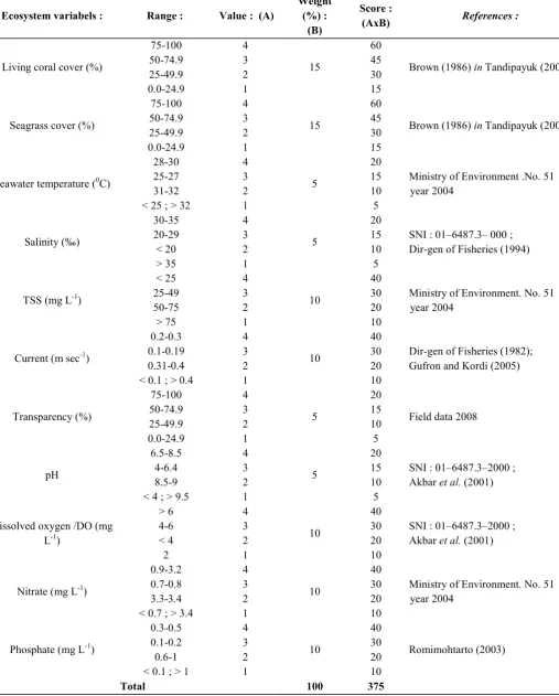
Table 1. Spatial score based on ecosystem variables
1 2 0 < $ %
Living coral cover (%)
75 100
Brown (1986) Tandipayuk (2006)
Seagrass cover (%)
75 100
Brown (1986) Tandipayuk (2006)
Seawater temperature (0C)
28 30
Ministry of Environment .No. 51 year 2004 Dir gen of Fisheries (1994)
TSS (mg L1)
Ministry of Environment. No. 51 year 2004
Dir gen of Fisheries (1982); Gufron and Kordi (2005)
Transparency (%)
Field data 2008
pH
Dissolved oxygen /DO (mg
L1)
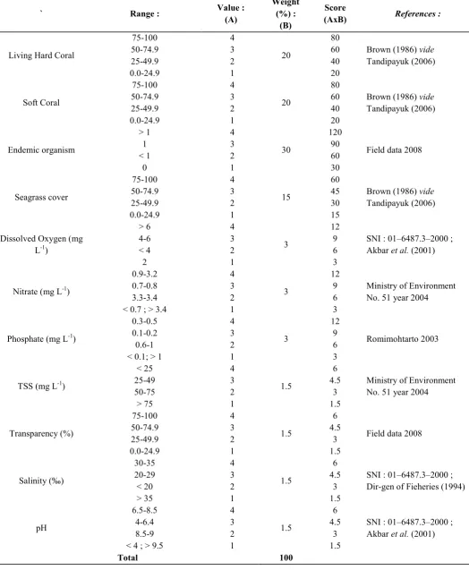
Table 2. Spatial score based on endemic organism
Living Hard Coral
75 100
Field data 2008
Seagrass cover
Dissolved Oxygen (mg
L1)
Ministry of Environment No. 51 year 2004
Ministry of Environment No. 51 year 2004
Field data 2008
Salinity (‰) Dir gen of Fieheries (1994)
©
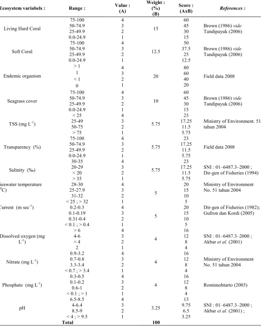
Table 3. Spatial scoring based on combination of ecosystem and endemic organism variables
1 2 0 <
Living Hard Coral
75 100
Field data 2008
Seagrass cover
Ministry of Environment. 51 tahun 2004
Transparency (%)
75 100
Field data 2008
Salinity (‰) Dir gen of Fisheries (1994)
Seawater temperature
(0C)
Ministry of Environment No. 51 tahun 2004
Dir gen of Fisheries (1982); Gufron dan Kordi (2005)
Dissolved oxygen (mg
L1)
Note :
1. Value class based on Dir gen of Fisheries (1982) : 4 : Very good
3 : Good 2 : Fair 1 : Inadequate
2. Weight based on dominant variabels, range : 3.25 30 3. Score :
∑ =
=n
1 i
AxB
13:;, .9 9 3 :33 ).
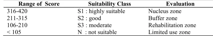
As a representation of a deep water reef ecosystem as found in Taka Bonerate was characterized with the presence of some atolls and sand dune (bungin). This mean that the reef ecosystem was surrounded by deep water ecosystem. This kind of deep sea coral reef ecosystem was regarded as a vulnerable ecosystem since this kind of ecosystem would be highly sensitive to any environmental changes such as seawater temperature anomaly, tide ranges, etc. Results of scoring and suitability classes were presented as in Table 4, 5 and 6 below.
Table 4. Result of score and suitability class based on ecosystem variables
0 3 3 2 1
301 400 S1 : highly suitable Nucleus zone
191 300 S2 : good Buffer zone
91 190 S3 : moderate Rehabilitation zone
< 90 N : not suitable Limited use zone
Table 5. Result of score and suitability class based on endemic organism variables
0 3 3 2 1
301 400 S1 : highly suitable Nucleus zone
201 300 S2 : good Buffer zone
101 200 S3 : moderate Rehabilitation zone
< 100 N : not suitable Limited use zone
Table 6. Result of score and suitability class based on ecosystem and endemic organism variables
0 3 3 2 1
316 420 S1 : highly suitable Nucleus zone
211 315 S2 : good Buffer zone
106 210 S3 : moderate Rehabilitation zone
< 105 N : not suitable Limited use zone
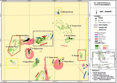
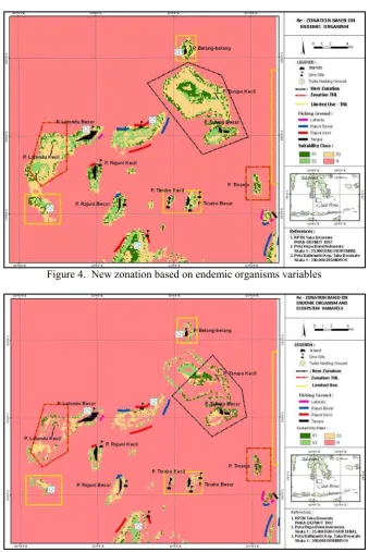
With an approach using ecosystem (water quality) variables for the spatial scoring and zonation as in Table 4 with special emphasis on weight of 50% for TSS, current, DO, nitrate and phosphate had resulted on the presence of real extent or wide area which is then can be regarded as the real ecosystem extent or border of the nucleus zone as seen in Ratondu Besar, Rajuni Kecil and Tinabo Besar island (Fig.1). This finding on the ecosystem based spatial scoring which then can shows and prove to us the real natural extent, the wide or the real ecological border of its specific ecosystem function such as the spatial distribution of specific endemic larvae or necton, and thus can be used to delineate or to add a buffer for the nucleus zone and not just a squared rigid delineation as always done so far. Spatial scoring using endemic organisms with total weight of 85% (hard and soft coral, sea grass and endemic organism) even had give more clear and ensure the S1 suitability class as nucleus zone had been confirmed at Ratondu Besar, Ratondu Kecil, Tinana islands as in the earlier marine park zonation and adding for Tarupa Kecil and Tarupa Besar after the new zonation (Table 5 and Fig 2). The category as nucleus zone with S1 suitability class was based on the score and consideration with presence of about 17 family, 61 genera and about 41 species of hard coral, soft corals, zoanthids (Appendix 1), the protected reef fish napoleon wrasse (
). Endemic mollusk such as % ,
, triton ( , % & , several of giant
clams % , pearl oyster ( .), and the most
important of all was the presence of the living fossil hollowed
nautilus ( ). The presence of this endemic
living fossil in this specific ecosystem should be regarded as a genetic richness of the area. Taking into account the importance of genetic richness of the living fossils such as
! and
had been found in Indonesian seas would be the new paradigm in designing and managing the so called as MPA Plus by means of the level of marine biodiversity. This new concept of MPA Plus should be recognized in the international, national as well as at the local level, in order to set new approach and management of this MPA Plus since this new paradigm was poorly understood so far. A step by step guide and training modules for the local society, fisherman and authorities to know and understand the morphology of the living fossils, where to find, how to make active participatory management, preserve and conserve by means of in situ rehabilitation programme should be take into actions in the future.
As well as the presence of the flying fish larvae (nekton)
and was regarded that this
©
inevitable. While new zonation using combination of ecosystem and endemic organisms variables to some extent had also confirm for a new zone at Tarupa Besar and Tarupa Kecil islands (Table 6 and Fig. 3). The real problem on the field as found at Taka Bonerate marine park was actually Illegal fishing, there were about 23 events of bomb fishing and 9 event use of poisons (TNL Taka Bonerate in Nur Asmiar 2005). As stated in SBSTTA 14 4, UNEP CBD (2010) a further emphasis on the impacts of destructive fishing practices, unsustainable fishing and illegal, unreported and unregulated (IUU) fishing on marine biodiversity, in collaboration with FAO and the regional fisheries management organizations (RFMOs) some firm regulation and actions should be made.
Priority should be given to the following, in order to
overcome the identified barriers and constraints, ,
enhancing cross sectoral coordination and policy planning in regard to marine and coastal areas; enhancing coordination between levels of Government, with emphasis on local implementation; developing and strengthening stakeholder networks; demonstrating the economic and social value of marine and coastal biodiversity; undertaking periodic review of the adequacy of policies and legislation and their implementation; securing resourcing and funding through forward planning; enhancing capacity of personnel through training; making scientific information and traditional knowledge easier to access through improved information management; scaling up and replicating demonstration projects; developing regional collaboration to address scientific information needs; developing or further enhancing spatial approaches to data management; developing international scientific expertise and processes for assessing and managing poorly known ocean areas such as the deep sea, and providing information about the status of marine biodiversity globally, as well as management options; and identifying areas of global ecological and biological significance in marine areas beyond
national jurisdiction. Drawing upon the findings and recommendations of the in depth review and existing reports, the present note recommends some areas to be considered in updating the existing programme of work, in regards to,
: (i) biodiversity conservation in marine areas beyond national jurisdiction; (ii) aspects of marine biodiversity related to climate change and addressing ocean acidification; (iii) impacts of unsustainable fishing; and (iv) improving the representativity of the global system of marine and coastal protected areas.
Noting that the world's oceans host 32 of the 34 known phyla on Earth and contain between 500,000 and 10 million species, and that new oceanic species are continuously being
discovered, particularly in the deep sea, ' Parties, other
Governments and organizations to further enhance globally networked scientific efforts, such as the Census of Marine Life, to continue to update a comprehensive global list of all forms of life in the sea, and further assess and map the distribution and abundance of species in the sea . The most up to date information about marine and coastal protected areas (MCPAs) can be found in the World Database on Marine Protected Areas
(http://www.wdpa marine.org/Default.aspx), which is
maintained by UNEP WCMC. Data for 2009 regarding numbers of MCPAs and area protected globally is not yet available, but the most recent information indicates that less than 1 per cent of the oceans globally are protected. The latest available statistics, from March 2008, show that there were then an estimated 4435 MCPAs worldwide. These MCPAs
covered approximately 2.35 million km2, which is equivalent to
0.65 per cent of the world’s ocean surface or 1.6 per cent of the world’s total EEZ coverage. Of the total area of MCPAs, a minority, or 12.8 per cent prohibit extractive activities. While it is likely that MCPA coverage has increased since 2008, with the declaration of new areas, it is evident that the world’s oceans and coastal areas are still under protected. (SBSTTA 14 4, UNEP CBD 2010).
Figure 4. New zonation based on endemic organisms variables
Figure 5. New zonation based on ecosystem and endemic organisms variables
Table 7. Appendix . Endemic Avertebrates of Taka Bonerate
.) . ;
3 . 8 ;6 ;8 ,6 , ,/ ,
37 /
1 Fire shrimp 2 2
6 4) .,7 9
2 Yellow zoanthid , 2 2 4
3 Trumpet brown 1 1
.1 ).
4 Brown carpet $ 1 1
©
.) . ;
3 . 8 ;6 ;8 ,6 , ,/ ,
9 3)A, ) ;
6 Short body $ 8 31 33 19 100 191
7 Soft cactus $ 2 6 16 8 18 3 53
8 Soft hair 1 1 2
9 Soft X'mas 100 100
10 Soft rose & 18 20 6 2 46
11 Soft long body $ 12 17 5 22 56
12 ( 10 5 3 2 20 40
13 - 26 100 13 100 239
1 7 9 ) ;
14 Blue staghorn 3 3 6
15 Green staghorn 1 1
16 1 1
17 3 2 5
18 Durian Coral . 4 3 2 1 1 7 18
19 Green, Brown, . 7 1 8
20 red plate / 1 2 1 1 2 7
21 Pineapple red 3 7 2 1 13
22 Pca 2 10 1 3 16
23 Root red & 1 3 1 1 4 5 15
24 Rice bubble 1 1 2 1 5
25 3 3 2 1 19 28
A 1 7 .)91
26 Holothuria /! 1 1 2
27 /! 1 1 2
28 2 1 3
B );;:3
29 Gastropods $ & 1 1
30 1 1
31 Bivalvia % 1 1
32 %! 1 3 4
33 %! ' 1 2 1 1 3 8
34 %! 1 1 2
35 %! 1 2 1 4
36 /! 1 1
37 /! 1 1
38 2 1 3
39 3 3
7 .1 ,). 0
40 ! +++ +++
41 ++
). ;:3 ).
The paper emphasis the development of a new paradigm on the “specific ecosystem and endemic organism spatial model”
and targeted existing knowledge for a beyond ‘the usual goals’ for Marine Protected Area (MPA). In this case is preserving
Taka Bonerate as well as in north Sulawesi waters and Limulus.sp in Java and Kangean seas, should be designated as a “new concept of MPA Plus”. Considering the important of deep sea vulnerable reef and atolls and sand dune (bungin) ecosystem for a protected reef
fishes : napoleon wrasse ( , and the larvae
of flying fish Cypsilurus.sp and others had confirm that this ecosystem is a spawning ground.
8.) ;19B1 1.,3
The authors would like very much to thanks to all staffs of Taka Bonerate Marine Parks authorities and all fisherman groups at Taka Bonerate for their sincere and generous helps, during the field data measurement and sample collections
1A1 1. 13
Akbar, S., Sudjiharno and Sumiyati. 2001. Pembesaran Kerapu Macan (Ephinepelus fuscogutatus) dan Kerapu tifus (Cromileptes altivelis) di Karamba Jaring Apung. Balai Budidaya Laut Lampung. Direktorat Jenderal Perikanan Budidaya. DKP RI.
Aziz, A., Kastoro, I. Aswandi, M. Adrin and M. H. Azkab. 1989. Panduan Wisata Bahari Pulau Genteng dan Sekitarnya. P3SL P3O LIPI ; Jakarta.
Balai Taman Nasional Taka Bonerate. 2002. Buletin Kima Edisi VI. Balai Taman Nasional Taka Bonerate. Benteng Selayar.
COREMAP PSTK Unhas. 2000. Laporan Akhir. Studi Optimasi Zonasi Taman Nasional Laut Taka Bonerate: Studi Saintifik 154 halaman, ditambah lampiran. PSTK Unhas, Sulawesi Selatan, Indonesia.
Hartoko, A. 2002. Aplikasi Teknologi Inderaja untuk Pemetaan Sumberdaya Hayati Laut Tropis Indonesia. Buku III;
& $ & 1
. Fakultas Perikanan dan Ilmu Kelautan. Universitas Diponegoro. Semarang.
Hartoko, A., M Helmi and Arlius. 2004a. Supply of Coastal Resource Thematic Datasets for West Sumatra, MCRMP Ministry for Marine and Fisheries & ADB.
Hartoko, A., M. Helmi and Arlius. 2004b. Supply of Coastal Resource Thematic Datasets for North Sumatra, MCRMP Ministry for Marine and Fisheries & ADB.
Hartoko, A. and M. Helmi. 2004c. Development of Digital Multilayer Ecological Model for Padang Coastal Water
(West Sumatera). 2 ( .Vol 7.
No. 3 hal 129 136.
Hartoko, A. and M. Helmi. 2008. Aplikasi Teknologi Inderaja dan GIS Untuk Analisa dan Pengelolaan Wilayah Pesisir dan Ekosistem Laut. Remote Sensing and GIS Technology for Marine Ecosystem Analysis and Management (MEAM) Image Processing–Basic I.
Hartoko, A. and A. L. Kangkan! 2009. Spatial Modeling For
Marine Culture Site Selection Based On Ecosystem Parameters At Kupang Bay, East Nusa Tenggara–
Indonesia. International 2 * $
$ (IJRSES) 6: 57 64.
Hartoko, A., I. Susilowati, T. W. Agustini and J. Hutabarat. 2010. Adaptation Strategy Towards Climate Change for the
Vulnerable Fisheries of Indonesia. Convention on Biological Diversity; United Nations on Environment Programs (Unep). Nairobi. Kenya.
Helmi, M. 2007. Analisis Zonasi Ekosistem Alami Pulau Kecil dengan Pendekatan Ekologi Lanskap di Pulau Karimunjawa dan Kemujan Taman Nasional Karimunjawa, Kabupaten Jepara Jawa Tengah (Tesis tidak dipublikasikan). Sekolah Pascasarjana Pengelolaan Sumberdaya Pesisir dan Lautan IPB; Bogor.
Kantor Menteri Negara Kependudukan dan Lingkungan Hidup. 1991. Strategi Nasional Pengelolaan Ekosistem Terumbu Karang.
Lensa Taka Bonerate.. 2006. Media Informasi dan Promosi
Taman Nasional Taka Bonerate, 2nd edition. Balai Taman
Nasional–Taka Bonerate; Selayar Sulawesi Selatan. 44p. LIPI. 1995. Laporan Ekspedisi Taman Nasional Taka Bonerate.
P3O LIPI; Jakarta.
Massi, K. A. R. 1996. Studi Kondisi Terumbu Karang di Taman Nasional Laut Taka Bonerate: P.Latondu Besar, P.Tinanja, P.Tarupa Kecil, P.Taka Lamungan, Sulawesi Selatan. Skripsi. Jurusan Ilmu Kelautan UNHAS; Ujungpandang.
Nontji, A. 2002. Laut Nusantara. Djambatan; Jakarta.
Nur, A. 2005. Monitoring Perubahan Luas Kawasan Terumbu Karang Taman Nasional Taka Bonerate tahun 1994 2002 dengan Metode Multitemporal Menggunakan Landsat TM (Skripsi, tidak dipubilkasikan). Program Studi Geofisika. Fakultas MIPA Unhas; Ujung Pandang.
Nybakken, J. W. 1988. Biologi Laut: Suatu Pendekatan Ekologis. PT. Gramedia Pustaka Utama; Jakarta.
Odum, E. P. 1993. Dasar dasar Ekologi. Gadjah Mada University Press; Yogyakarta.
Romimohtarto, K. 2003. Koalitas Air Dalam Budidaya Laut. At www.fao.org.doerep.
Sawyer, A. D. 1992. Taka Bone Rate: Pengelolan, Pengembangan dan Penilaian Sumberdaya dari Sebuah Atol di Indonesia. Dalhausie University Halifax, N. S.
Sub Balai Konservasi Sumberdaya Alam Provinsi Sulawesi Selatan. 1997. Rencana Pengelolaan Taman Nasional Taka Bonerate (1997 2000) Vol I III. Kantor Wilayah Propinsi Sulawesi Selatan.
Supriharyono. 2000. Pelestarian dan Pengelolaan SDA Pesisir Tropis. PT. Gramedia; Jakarta.
Tandipayuk, L. S. 2006. Kajian Pemanfaatan Sumberdaya Perikanan Terumbu Karang Berkelanjutan di Perairan Pulau Pulau Sembilan Kab Sinjai. Sulawesi Selatan. Disertasi. Program Pasca Sarjana Universitas Hasanudin ; Ujung Pandang.
Tulungen, J. J., T. G. Bayer, B. R. Crawford, M. Dimpudus, M. Kasmidi, C. Rotinsulu, A. Sukmara dan N. Tangkilisan. 2002. Panduan Pembentukan dan Pengelolaan Daerah Perlindungan Laut Berbasis Masyarakat. CRC Technical Report Nomor 2236. Departemen Kelautan dan Perikanan Republik Indonesia dan University of Rhode Island, Coastal Resources Center, Narragansett Rhode Island; USA.